Folsom Blvd safety improvements

I said in my post about the Sacramento Active Transportation Commission meeting of May 16, and in an eComment, that I was generally in support of the Folsom Boulevard Safety Improvements Project, agenda item 3. I am still in support of the project, but conversations with a number of people since them have pointed out weaknesses in the project that I will comment on.

  • Speed limit: The city does not propose to reduce the posted speed limit on the revised sections of roadway. The posted speed limit is 35 mph, and of course the design speed and typical speed is much higher. The reduction of general purpose (motor vehicle) lanes from four to two will result in lower speeds under some conditions, where a prudent driver sets the pace, but where there isn’t a prudent driver, other drivers will continue to travel well over the speed limit, creating the threat of traffic violence for all roadway users. Though not common, some drivers will use the center turn lane to pass slower drivers, increasing the danger for everyone. The city must reduce actual speeds with a safer design that enforces the desired speed.
  • Gutter pan bike lane: For several segments, the project proposes to keep the existing wide gutter pans and use them as part of the bike lane. This is probably illegal under state law, but even if not, it is poor practice. The gutter pans are acceptable in some locations, but in many cases are quite deteriorated and not rideable. Either the gutter pan must not be counted as part of the bike lane, or it must be replaced.
  • Lane widths: The projects indicates lane widths of 11 feet for the center turn lane and the two general purpose (motor vehicle) lanes, or 33 feet of the available roadway width. This is unnecessarily wide and will encourage drivers to travel at a higher speed than is safe. It is worth remembering that the fatality which initiated this project was due in part of excessive speed.
  • Bike lane design: The bike lanes are indicated as five feet. This is the minimum required by law, but is insufficient. It does not allow for safe passing of one bicyclist by another, and limits use by wider bicycles such as cargo bikes and three-wheeled bikes. The bike lane buffer is as narrow as 1.2 feet in some segments. This does not provide any real sense of security for less confident bicyclists. In some sections, the bicycle buffer has vertical delineators (shown as K-71 green delineators), but in other sections has no delineators. The narrow buffers and lack of delineators will not encourage bicyclists to use Folsom Blvd as a travel route. It might be better to improve bicycle facilities on M Street and Elvas Avenue, which is a parallel route commonly used by bicyclists, students and others, from east Sacramento to Sacramento State via the Hornet Tunnel.
  • Sidewalks: At no location in this entire project are sidewalk improvements shown. The sidewalks, where present, meet minimum standards, but do not have sidewalk buffers (planting strips), and there are several short sections with no sidewalk at all. Sidewalks without sidewalk buffers do not encourage people to walk. This is yet another city project with claimed safety benefits in which sidewalks are ignored as though they are not a critically important part of the transportation network. New ADA-compliant curb ramps are indicated in a few locations, but safer crossings are irrelevant if travel along the corridor is discouraged.
  • Slip lanes: The slip lane for 51st Street southbound at Folsom is retained. The small pedestrian island between the two travel lanes is not comfortable for walkers. The project also retains slip lanes for Folsom Blvd eastbound to 65th Street south, and 65th Street eastbound to Folsom Blvd east. Slip lanes are hazardous for all roadway users, and should be removed whenever a street in reconfigured.
  • Center turn lane: As with almost every project the city has proposed, there is a center turn lane along the entire length. I consider these to be a waste of roadway space except where the frequency of turning movements, to or from the major roadway, justify a center turn lane. Otherwise, they are just empty, seldom used space that could be better allocated to other uses.
  • Driveway closures: Driveways are the single feature that creates the most difficulty for people rolliing, and people walking. Commercial properties should be limited to one driveway in/out, of 20 feet, or two driveways, one in, one out, or 20 feet each. Twenty feet is required for commercial driveways by fire regulations. Where driveways are available on side streets for commercial properties, they should be used and driveways on the main roadway closed or greatly narrowed.
  • 48th Street flared intersection: The intersection of 48th Street to the south has a flared design, with extremely wide turning radii, leading to a crossing distance curb to curb of 140 feet! This is a crossing that intimidates walkers, yet the project makes no effort to correct this, or even acknowledge it.

In summary, this project presented as a safety improvement project has major weaknesses that reduce its effectiveness for safety. Remember that the fatality was on a sidewalk, and the result in part of a speeding driver. It was not a bicyclist. Of course I am in favor of higher quality and safer bicyclist facilities, but it seems to be the view of the city that if things are improved for bicyclists, walkers can be ignored. I strongly disagree.

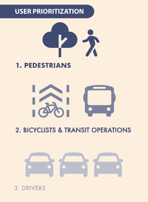
This is another city project that could be transformative, but falls short. The city is unwilling to make our streets significantly safer by prioritizing walkers over others. The General Plan has this diagram. Worth repeating again and again, until the city finally takes it seriously.

I have to admit that I missed a number of these issues when I quickly scanned the project document. If readers see additional issues that I have missed, please comment.

The cross-sections below are from the project document. Each is option two, which has more visual separation of bicyclists from motor vehicles by using buffers and/or vertical delineators. Option one does not provide any separation. But the buffers reduce the bike lane widths to five feet. Whether narrower bike lanes with visual protection, or wider bike lanes with no separation except a white stipe, are better, is a question I do not have a clear answer for. But modern bikeway designs provide both visual, or actual, protection, and wider bike lanes. These bicycle facilities are the minimum acceptable.

Folsom Blvd cross-section, 47th to 53rd, option 2
Folsom Blvd cross-section, 53rd to 63rd, option 2
Folsom Blvd cross-section, 63rd to 65th, option 2

more Central City Mobility Project

This is Central City Mobility Project update #5.

The City of Sacramento’s Central City Mobility Project is underway, and projected to finish by next May. The map below shows the major components of the project: new parking protected separated bikeways on 19th Street and 21st Street between W Street and I Street, extended parking protected separated bikeways on P Street and Q Street from 15th Street to 21st Street, a separated bikeway (not parking protected?) on I Street from 21st Street to 12th Street, and conversion of 5th Street from a one-way street to two-way from Broadway to I Street (the two-block section from L Street to J Street is already two-way). The project also includes upgrades of corner ramps to ADA compliance along 21St, 19th, P, Q and I streets. I notice that ramp upgrades are also occurring at some locations other than these streets, whether under this project or a separate initiative, I’m not sure.

Central City Mobility Project map

As far as it goes, this project looks to be great. The city is making an effort to create a grid of higher quality bicycle facilities in the central city, of a mile spacing, or less. But a bicycle network is only as good as it’s weakest spot, and this project leaves several weak spots in the grid. The map below highlights some of these, shown in cyan color:

  • P Street and Q Street parking protected separated bikeways should be extended west to 5th Street, which would include a reduction of lanes on those streets. Stopping the bikeways at 9th and 10th Street reduces access to Sacramento Valley Station, as well as many other destinations in this area, including using the Tower Bridge to access West Sacramento.
  • 9th Street parking protected separated bikeways should be extended from Q Street south to Broadway, to provide access to the higher quality bikeway along Broadway, and points south of Broadway.
  • I Street separated bikeway should be extended from 12th Street west to 5th Street, created a complete bikeway from 21st Street to Sacramento Valley Station.
  • J Street parking protected separated bikeway should be extended east from 5th Street to 19th Street, to proved a complete bikeway from 5th Street to 28th Street.
  • A separated bikeway should be constructed on 28th Street to provide a high quality bike route parallel to the unsafe 29th Street one-way southbound traffic sewer and 30th Street one-way northbound traffic sewer.
  • Regular bike lanes, at a minimum, should be installed on 13th Street between P Street and Capitol Park. 13th Street is one of the most heavily bicycled north-south routes in the entire central city, but this two block gap makes that trip less safe.

It is also possible that the P Street and Q Street bikeways should be extended east at least to 28th Street, or beyond, but I haven’t looked closely at that yet.

Central City Mobility Project map with recommended additions
Read More »

lower speed limits on complete streets in Sac

The eternal argument on speed limits has resurfaced on Twitter. The binary solution is: a) lower speed limits, or b) redesign roadways. This is a false dichotomy, to which I answer yes! Ultimately, the solution is to redesign roads (and motor vehicles) so as to physically enforce posted speed limits. But in the meanwhile, speed limits that are posted too high for urban areas (and with speeds that alway exceed that, because the road was designed for a higher speed than is posted) should be reduced.

There are two types of speed: posted speed, on the speed limit sign, and design speed, the speed that the road was designed for. Design speeds have traditionally been much higher than posted speeds, at least 10 mph higher, and often more, because the traffic engineer’s value system says that we must always protect drivers from their errors by providing a road that is safer at higher speeds. This is highway design thinking, applied to city streets, and is always inappropriate outside freeways and rural roads (and maybe even there). Protecting other users of the road (walkers and bicyclists) does not traditionally figure into this at all.

As a starting point, local or residential streets should be 20 mph maximum, collector streets 30 mph maximum, and arterial streets 40 mph maximum. These are maximums, more than is appropriate for many roads. 40 mph may never be appropriate in an urban area. Of course most arterial streets are stroads, roads designed for higher speeds but then knee-capped my multiple driveways and intersections. These roads should never have been built that way, or allowed to evolve that way, and must be radically changed.

Existing posted speed limits for the city are available.

It should be noted that most research indicates that the majority of fatality and severe injury crashes are caused by people egregiously exceeding speed limits, by 10 mph or more. It is not unusual for speed surveys, and the rare law enforcement, to record a few drivers exceeding freeways speeds on surface streets. Roadway design, along with lower speed limits, probably does little to change the behavior of egregious speeders, and those are better addressed through automated enforcement.

The City of Sacramento has a number of complete streets or road reconstruction projects underway or planned. Two significant ones are Northgate Blvd and Stockton Blvd. Stockton is on the city’s high injury corridor Vision Zero plan, Northgate is not.

Stockton Blvd

The city has been through several cycles of planning for Broadway and Stockton Blvd. The current plan is the Stockton Blvd Plan – Community Working Version. Though public concerns about motor vehicle speed have been a recurring theme, the city plans to address this by reducing travel lanes and planting trees. They do not intend to reduce the posted speed limit. In fact, speed limit is hardly mentioned in any of the documents. In fact, design speed is never mentioned. The city is pretending that posted speed limits have nothing to do with roadway design. The city is not willing to share with the public its intended design speeds.

The posted speed limits on Broadway and Stockton are 35 mph and, south of Lemon Hill, 40 mph. Broadway and Stockton are ‘other principal arterial’ in the state functional classification system, one step below freeway. And much of Stockton’s current design is very freeway-like. Given the intensity of uses along both Broadway and Stockton, posted speed limits of 30 mph would be appropriate. Instead, the city intends to maintain 35 mph and 40 mph for the redesigned road. This will ensure that they remain stroads rather than streets.

Northgate Blvd

Northgate Blvd is not on the city’s high injury corridor Vision Zero Plan, but was identified because it is a road with intensive local use in a disinvested community. The planning effort for Northgate is in an earlier stage. An existing conditions report, appendices, and initial community outreach are available. These reports document that posted speeds are mostly 40 mph, with a small section 45 mph. Recorded speeds are not that far off from posted speeds. but then again, the 40 mph speed is above what one would normally find in an urban area. Northgate is a ‘other principal arterial’, one step below a freeway. Parts of Northgate are have freeway-like designs, but most of it is more like a simple stroad.

Though public concerns about motor vehicle speed have been a recurring theme, the city plans to address this by narrowing travel lanes and planting trees. I participated in the initial workshop on Northgate, and I and others asked whether the posted speed limit would be reduced. The answer was no. But it is early enough in the planning process that this could be changed by public pressure. Another online workshop was scheduled for yesterday (I was unable to participate), and an in-person open house will be October 22 (Saturday, October 22 from 11:30am-1:30pm at Garden Valley Elementary School).

The city’s standard answer to questions about reducing speed limits is that they cannot be changed, because of the 85% rule (not a law, but guidance by Caltrans and courts), but this is incorrect. When a street is reconstructed, whether complete streets or other, the city can design for and set whatever speed limit it wants. It is as though a new street is being constructed. But the city doesn’t want to see it that way.

I think to redesign a road without seriously considering a reduction of the posted speed limit, as well as the design speed, is throwing money down the toilet. These projects will probably be in place for 30 years. 30 years of less than ideal design, 30 years of less than a fully functional and livable street, 30 years of failure to take climate change seriously, 30 years of unnecessarily high fatalities and severe injuries.

Background

Research on the effects of reducing posted speed limits are mixed. Some have indicated a significant impact, particularly at the higher end of the speed range (over 35 mph), and others indicating no significant change. Though even one life saved by a lower posted speed limit is worthwhile to me, it also points out that the ultimate solution to speeding is not just posted speed limits, or enforcement of those, but also roadway redesign. As I said, both!

Law enforcement of speed limits has been well documented as a tool of harassment and oppression of people of color and low income, so I am not in favor of in-person enforcement. Automated enforcement can easily manage speeds and particularly egregious speeders.

Streetsblog: Vision Zero Cities: How to Fix Our Most Dangerous Roads

Streetsblog: STUDY: 20 Is Plenty — But Signs Alone Don’t Always Get Drivers to Slow Down

Caltrans Setting Speed Limits

NACTO City Limits: Setting Safe Speed Limits on Urban Streets

Would it be easier to speed-limit vehicles?

In my previous post, Yes, and lower speed limits, and many others, I’ve written about speed and and need to reduce vehicle speeds. This can be done in a number of ways, most effectively by redesigning streets. But street redesign is a multi-billion dollar undertaking just in our region, and that is a conservative estimate.

Thinking outside the box, what if we speed-limited vehicles instead? What if all vehicles were limited to the posted speed limit? Many newer vehicles already have most of the technology needed: cruise control and location awareness through GPS. They would need some modification to use the cruise control to limit the speed, not to what the driver sets it at, but what the speed limit is. Shouldn’t cost much money for the conversion. Old vehicles, of course, don’t have this technology, and would need a fairly expensive update. How expensive, I don’t know. I’m not a technology person, and can only express surprise that either researchers are not researching this, or that if they are, it isn’t making it into the media.

During the transition period, I can see two actions that would encourage conversion. One is similar to emission inspections, where once your car becomes unable to pass inspection, and it would cost more to fix it that it’s value, it is retired. Of course in California, that means the car is shipped to another state to keep polluting, and that is not a good solution. The other is that there would be a penalty for not installing the conversion. The penalty would gradually increase over time. There are very obvious equity issues about this proposal. Maybe a cash-for-speeders program to buy and retire vehicles without speed-limiters. And it is not as though our current system is without equity implications. People of color and low income are much more likely to be the victims of crashes as are others, and we certainly know that speed enforcement can and is used to oppress people of color and low income.

Speed-limited vehicles would be a huge investment, for the updates required of newer vehicles, and the addition of the technology to older vehicles. I strongly suspect that it would be much less than the investment of fixing all our streets. Of course, we eventually still want to fix our streets in locations that are not triaged out, to make them livable and economically vibrant places, but with speed-limiting, we would have more time to work on that.

I would exempt two-lane rural roads from speed-limiting. Though a lot of crashes do occur on these roads, the valid need to be able to pass slow moving vehicles remains, and the scheme would just not work here. All other roads, yes. It might even be possible to increase speeds on freeways, where variability in speed is as much of a problem as speed itself.

Of course cars-first people would scream that this attacks their god-given and constitutionally-guaranteed right to drive as fast as they can. But these are the car nuts, just like gun nuts, that claim a right to do what they want to do without any consideration of the effect on others. It is time we grow up and recognize that vehicles are deadly weapons that must be limited to reduce mayhem.

Will autonomous vehicles solve this problem? Perhaps. These vehicles will certainly have full awareness of the posted speed limits on every street (part of the reason they are bandwidth intensive). I suspect that most autonomous vehicles will be part of commercial fleets (buses, delivery vehicles, ride hailing). Given the legal liability of allowing these vehicles to exceed the speed limit, I don’t think companies will. Of course there will be private owners who hack their autonomous vehicles to exceed the speed limit, but in a world of speed-limited vehicles these will stand out and be dealt with. The real issue, though, is that there will be a very long period of transition in which most vehicles on the road are not autonomous.

I welcome comments from anyone more technologically savvy than I, who can help me better understand the technological issues and solutions.

Yes, and lower speed limits

I believe that stroads should be turned back into Streets, and roads preserved for their transportation function. I’m a Strong Towns member, and fully support the argument that the best solution to stroads is to reconstruct them into streets. #SlowTheCars is the right approach. Key to that approach is that changing speed limits doesn’t do much to slow cars, and that ticketing people for going the design speed instead of the posted speed is often just a pretext for profiling and oppression.

BUT. It will be a long while and trillions of dollars to accomplish that. Undoing the damage of the past is not easy, because the money it would take to fix everything has long since gone into the pockets of those who profited from unsustainable (socially, economically, environmentally) development. We will have to triage, changing the most dangerous places first, and those places with the best chance of becoming walkable, livable, and vibrant second. We may never, and perhaps should never, get to those places that are the model of the suburban experiment. Many suburban places will fail and go back to agriculture. Others will not. But spending a lot of money to fix a suburban stroad, adding sidewalks and bike lanes and street furniture, will be good money after bad because these places won’t ever be dense enough or successful enough to pay back the investment.

Back to speed. It will be a long while before we can lower the design speed of stroads and streets back to the correct speed. In most cases, that design speed should be 20 mph. Occasionally higher or lower, but mostly 20. In the interim, I think that we should reduce the speed of all urban streets, that are not arterials and collectors, to 20 mph. I am not suggested that this limit be tightly enforced, as the point is not enforcement but education and commitment. A community willing to lower the speed limit to 20 is a community willing to think about safety and livability, and to accept that the way we have done thing in the past is absolutely not what we need in the present or future. Setting speed limits to 20 is a message to pay attention and think about consequences. Portland and Seattle have recently reduced some speed limits to 20.

Read More »

J Street Safety Improvments

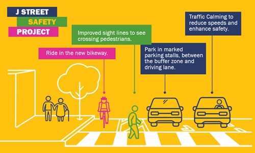
The City of Sacramento is going to use street rehabilitation funds (from SB-1) to create a separated bikeway on J Street between 19th and 30th, starting this summer. The city held a public meeting last night (January 25) to gather public comments on the design elements, which have not been finalized.

I like the proposal, and see it as a significant improvement over what is there now. The general purpose travel lanes would be reduced by one, from three to two, while bike facilities would be increased from zero to one. The separated bikeway, also called a cycle track or protected bike lane (separated bikeway is the correct term in California) would be installed along the right side of the one-way street. The project will improve pedestrians safety by shortening the crossing distance over general purpose lanes, but this is more a traffic calming and bike facility project than a pedestrian project. This project is intended to be a “paint only” project that fits with the funds available. Improvements needing concrete would come later, if at all. The separated bikeways would be “protected” with flexible delineator posts between the parking lane and the bikeway, which provides increased safety but not full protection.

Though the diagrams shown last night indicate that bus stops would be at the existing curb, and the bikeway with green paint would swing around the bus stop to the left, it appears that the city is rethinking that and will use a shared bus/bike lane for the length of the bus stop. There is talk of moving bus stops to better locations, and perhaps reducing the number of stops for better service times. The only bus currently using J Street is SacRT Route 30, which has a 15 minute frequency on weekday day times, 30 minute evenings and Saturdays, and 60 minute Sundays. This is a route whose ridership probably justifies 10 minute frequency day times.

The intersections will be daylighted by removing the parking spaces that currently are right up against the crosswalks and reduce visibility between drivers and pedestrians. I completely support that and feel that the safety benefits make the loss of a few parking spaces worthwhile. I’m not against on-street parking, in fact I like it because it slows traffic, but safety is even more important.

I would like to recommend some improvements to the project as presented:

  • Reduce lane widths from 11 feet to 10 feet. This is the most important action that could be taken to enhance safety. The best action for pedestrian and bicyclist safety is to #SlowTheCars (@StrongTowns). The narrower the lanes, the slower the traffic, and the slower the traffic, the less severe collisions that do occur, and the less collisions. The city currently has an 11 foot standard they don’t seem ready to change, but what better time than now to create a significant project with narrower lanes, so we can directly experience the safety benefits.
  • Reduce the speed limit to 20 mph, and stripe the street in a way that encourages this actual speed. Again, the city is reluctant to go below 25, but there is a growing national movement to 20 mph in urban areas. Goes hand-in-hand with the lane width reduction, and is very inexpensive to implement.
  • Stripe the separated bikeway and street in such a way that the shared bus/bike lane at bus stops can be converted to floating bus islands with the bike lane at the curb. This configuration keeps the bus in the flow of traffic, which greatly speeds bus times as they don’t have to wait for a gap in traffic to continue. I do not know how wide the islands need to be to accommodate bus shelters, but am looking into that and will report. Another advantage of the lane width narrowing is that it would provide another two feet for the islands. The separated bikeway “lane” is seven feet, and that seems fine to me. Since this is a “paint only” project, concrete bus islands would delay it for additional finding, which I don’t want to see, but the design should be ready for bus islands as soon as they can be funded.
  • Reduce the number of bus stops to one every three or four blocks. The increase in service speed makes the greater walking distance worthwhile, and since the walking environment will be more appealing and safer, this is a good trade-off.

The meeting last night was the only formal opportunity to have input to this project, but I encourage you to email Jennifer Donlon-Wyant with support for the project, for these improvements I’ve presented, or you own ideas. You can also comment here, but emailing Jennifer is the first step.

speed limits

I can be an incredible cynic sometimes, but here goes another one. Particularly true of drivers in the suburbs, and of suburban drivers in the urban areas, but more widespread than just that.

What drivers see
What drivers see

What drivers understand

R Street suggestions

R Street, the part to be improved

The City of Sacramento and CADA held a community meeting on November 23 on the R Street Phase III Streetscape project, presenting design alternatives for the section of R Street between 13th and 16th streets. Phase I is the already completed portion between 10th and 13th, and Phase II is the upcoming portion between 16th and 18th. Three alternatives were presented for each of the three blocks, basically representing three different levels of traffic calming and devotion of right-of-way width to pedestrians rather than vehicles. Alternative three for each block includes curb extensions or bulb-outs at most corners. All the alternatives include wider sidewalks.

I am glad to see the city moving forward on these improvements, with the already completed Phase I making a huge difference to the usability and appearance of the street. Though the most economically vibrant portion of the street currently is this section from 13th to 16th, it will unfortunately be the last to be completed.

Read More »