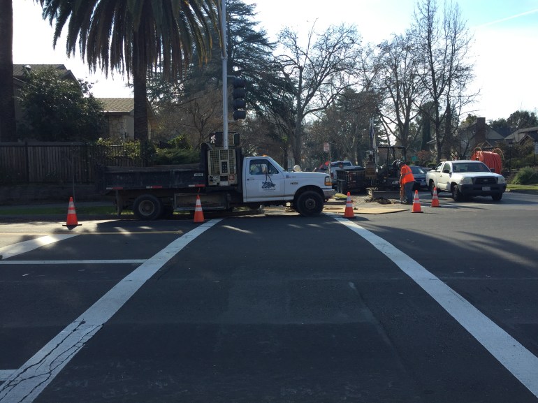
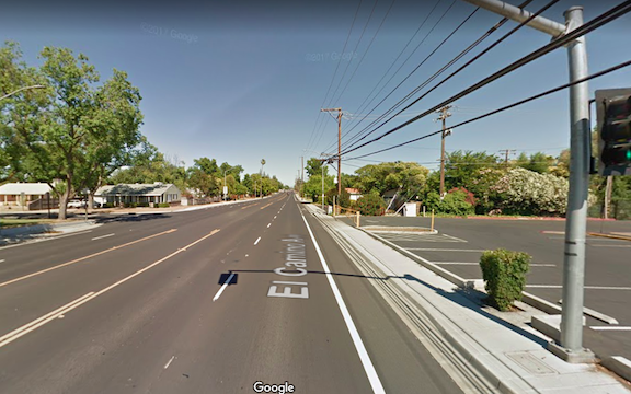
Complete Streets aren’t

The Complete Streets movement, now 13 years old and with a newly released criteria for evaluating policies, is considered by some to be a success. Not by me.

There are two gaping flaws in the complete streets concept, that after all this time have not been addressed:

  • Who is responsible for sidewalks?
  • How close should safe crossings be?

Sidewalks: On the first issue, responsibility for sidewalks, most cities and counties (not all) have code that makes sidewalk maintenance the responsibility of the adjacent landowner. This includes repair and snow removal. Most cities have some money set aside to repair sidewalks, but only a tiny fraction of what is needed for the huge backlog of deteriorated sidewalks. A very few cities also clear sidewalks after snow. Sidewalks are every bit as much of the transportation network as travel lanes and bike facilities, but most places wash their hands of this reality and this responsibility, pushing it off to others. It has been pointed out that few cities and counties have the funds to also take care of sidewalks, but that is exactly the point. If we allow cities and counties to prioritize cars over walking, they will continue to do so.

How does complete streets play into this? It doesn’t. Complete Streets set no expectation that cities and counties will maintain their sidewalks. In the new policy rating documents, the word sidewalk only shows up twice, neither in this context. Even a search of the Complete Streets website only mentions sidewalks in relation to case studies and model projects. Fortunately, a few places do much better than just have a policy, but the Complete Streets movement does nothing to encourage this.

ElCamino-eb
El Camino complete street, 0.3 miles to the next safe crossing

Crossings: the second great weakness of the complete streets movement and Complete Streets documents is the lack of attention to frequent safe crossings. The new criteria does not mention crosswalks or crossings. The illustrations of a complete street often show an intersection with high visibility crosswalks and sometimes curb extensions to increase visibility and shorten crossing distance. But other illustrations show long distances along a “complete” street, with the next safe crossing often not visible.

In the Sacramento region, every complete street project along arterials has added sidewalks and bike lanes, but none of them have added safe crossings. In fact, several of them have removed crossings. If a busy street is hard for walkers to cross, they won’t cross it. They will either drive, or just avoid the other side of the street. So that fancy complete streets project, with the wonderful looking wide sidewalks, does not serve the very people it is claimed to serve. People need to be able to cross any land all Streets in a safe crossing at an interval of no more than 1/8 mile. The grid in downtown Sacramento is 1/12 of a mile. Few places in the suburbs are less than 1/4 mile, and many are 1/2 mile. To me, this is unacceptable. I would think a complete streets policy would address this distance between safe crossings issue as being key to walkability. Again, the Complete Streets movement ignores this issue.

Getting around… with a knee scooter

I fractured a bone in my right foot on July 7 while backpacking along the Pacific Crest Trail in the Granite Chief Wilderness. I initially thought it was a tendon problem, because I’d had some discomfort with the tendon before, however, in stepping on the outside edge of my foot on a rock, the pain level increased manifold. I walked out on it. On Friday, I went into the doctor, got an x-ray, and now have a lower leg cast. What does this have to do with transportation? Well, I’m now getting around with a knee scooter, rather than walking or bicycling.

It has been interesting, and here is my take on it so far. The knee scooter has small wheels, about eight inches, so it is less stable than a bicycle, or a wheelchair. Because it is somewhat unstable, I use a lot of energy maintaining balance. Though I’ve noticed, now that I’m paying more attention to people using wheelchairs, that the unpowered ones are not all that stable either. But it does move along quickly, faster than walking though not as fast as bicycling.

Read More »

Embassy Suites is pedestrian hostile

sign adjacent to Capitol Mall sidewalk at Embassy Suites

The sign at right is posted prominently at the eastern driveway of the Embassy Suites Sacramento, on Capitol Mall at Tower Bridge. The sign is illegal, as no sign on private property can direct people on public property what to do, particularly when the sign uses the standard red octagon which is reserved for official stop signs. But more importantly, it is offensive to anyone who walks. What is the hotel saying by posting this sign? That we welcome people who drive cars, who should not have to stop for pedestrians even on the sidewalk, and we reject people who walk, because they are second class citizens, not our customers? This sign has been here at least since December 2013, and I have talked to management at the hotel twice about it, and it is still there today. They really don’t care.

TransForm’s Transportation Choices Summit took place today at the Embassy Suites. I’m not sure how many participants approached from a direction that they would have seen this sign, but I would guess that everyone who saw it was offended. This sign directly works against the efforts of every single person who attended the summit.

I have to publicly ask that TransForm, and everyone else, boycott Embassy Suites until this sign is removed.

N Street bike route to cycle track

Unknown, or unnoticed, by many people, there is a bike route along N Street on the sidewalks. The route is well-signed from 8th St, where it crosses over from the south side to the north side of N Street, to 12th Street. The route extends east along Capitol Park to 15th Street, and I believe it also extends west to 3rd Street, though it is not well signed at these ends. On the City of Sacramento bikeways map, the route is shown on both sides of N Street, as “Existing Off-street (wide sidewalk).”

The bike route allows bi-directional travel along N Street, which would otherwise not be possible. The city has recognized that N Street is a significant barrier to east-west bicycling.

Read More »

I Street into Old Sacramento

The City of Sacramento sponsored Envision Sacramento website seeks input from the public on a number of issues. One of the topics was “What are your ideas on improving the Old Sacramento connection from downtown Sacramento via I Street?” You can view the comments, just below the survey, but to comment yourself you must create an account.

I Street entrance to Old Sacramento, from Envision Sacramento

The topic uses the photo at right to illustrate the question. What you can’t see in the photo is that behind the photographer and across 3rd Street (to the left), pedestrian access is on the south side, but to the west, it is on the north side.

Comments include a number about the aesthetics of this entrance to Old Sacramento, including the having a dark freeway under crossing as the main route into the one of the highlights of Sacramento, with poor signing for motor vehicle drivers, bicyclists, and pedestrians. A surprising (to me) number of comments, though, were about the transportation aspects, that it is really not safe for bicyclists or pedestrians to use this entrance, even if they know it is there, and the paucity of other options. I think it is clear that the commenters agreed that the way in which Interstate 5 severed the connections between downtown and Old Sacramento is a major issue.

A gallery of photos shows some of the specific problems at this location.

Read More »

Gallery: I Street into Old Sacramento

These photos are of the I Street entrance to Old Sacramento, showing various problems and hazards that exist for pedestrians and bicyclists at this location. The crosswalks here are not really safe. All sorts of signing has been installed to try to make them safe, but that is a poor substitute for correct design. The […]

Sacramento Riverfront Reconnection, Phase 1

2nd Street extension to Capitol Mall

SACOG in the 2013 funding round allocated $9M to the Riverfront Reconnection project in the City of Sacramento. This phase extends 2nd Street from Old Sacramento to Capitol Mall, providing an easier access to Old Sacramento, and also adds sidewalks to O Street and improves sidewalks and bike lanes on Capitol Mall between 3rd Street and the Tower Bridge. The overall purpose is to create or restore connections between downtown Sacramento and Old Sacramento which were severed by Interstate 5.

Read More »

R Street suggestions

R Street, the part to be improved

The City of Sacramento and CADA held a community meeting on November 23 on the R Street Phase III Streetscape project, presenting design alternatives for the section of R Street between 13th and 16th streets. Phase I is the already completed portion between 10th and 13th, and Phase II is the upcoming portion between 16th and 18th. Three alternatives were presented for each of the three blocks, basically representing three different levels of traffic calming and devotion of right-of-way width to pedestrians rather than vehicles. Alternative three for each block includes curb extensions or bulb-outs at most corners. All the alternatives include wider sidewalks.

I am glad to see the city moving forward on these improvements, with the already completed Phase I making a huge difference to the usability and appearance of the street. Though the most economically vibrant portion of the street currently is this section from 13th to 16th, it will unfortunately be the last to be completed.

Read More »

the problem with rolled curbs

Curb&GutterDiagramsRolled curbs slope up from the gutter pan to the sidewalk, whereas standard curbs have a more vertical face. Standard curbs are both old and modern, but there was a period of time in the 1950s through 1970s when rolled curbs were very popular, seen as a sign of the new suburbs. In the grid area of Sacramento, including the first ring suburbs, standard curbs are quite common. In the second ring suburbs and the sprawl suburbs, rolled curbs are quite common, not only being found in residential neighborhoods but even on arterial roads.

parking up on the sidewalk with rolled curb

So, what’s the problem with rolled curbs? Drivers use rolled curbs to drive up on the edge of the sidewalk, constraining the sidewalk width, reducing walkability, and not infrequently causing blockage of the sidewalk for people in wheelchairs. ADA regulations require at least 36 inches of clear width. Combine the narrow 4-foot sidewalks that were popular in the suburbs with this driver behavior, and the car-influence zone is expanded to the complete width of the right of way, leaving no place for pedestrians. [Note: This photo is for illustration purposes only, not to give this driver a hard time. This is common practice, and I’ve seen many instances where much more of the sidewalk was blocked.]

A side affect of parking up on sidewalks is that it leaves more of the street width for moving motor vehicles, which then increases the speed at which people drive. By trying to get their vehicles out of the way of the “speeding drivers,” they are actually making it easier for drivers to speed.

What are the solutions?

Read More »

whose responsibility are sidewalks?

broken sidewalk, Sutterville Road at 24th Street

Note: As I wrote this post, I realized that some background info was needed, hence two related posts: sidewalk buffers and surprisingly good sidewalks.

This week an article in the Sacramento Business Journal, “Rancho Cordova wants to make sidewalks problem of property owners,” talked about the city’s efforts to shift responsibility for sidewalks to the property owners, both residential and commercial. The city spokesperson, Davis Gassaway, attempts to gloss over the impact by saying that it should only cost $1000-1500 to repair a sidewalk, and that Sacramento, Roseville, and West Sacramento already have such ordinances. I think the costs quoted are on the low side. At about $4 per square foot (significantly more for curbs), $1000 would buy 50 linear feet of five foot wide sidewalk in a residential area, and 25 linear feet of ten foot wide sidewalk in a commercial/mixed use area. And just because another city is doing it doesn’t make it a good idea. So, what’s wrong with the idea?

Read More »