The SacATC 2026-10-15 meeting will receive a information and comment update on the Franklin Blvd Complete Street Phase 3 project. The project is at the 60% design stage, meaning that plans have been drawn (see the SacATC 2026-10-15 post), but details can still be improved. I have had some time to review the presentation and design diagrams, so have some comments, based on these and on my previous post on the Phase 1 and 2 project which is complete. The Phase 1 and 2 project ended at Fruitridge Road. There have been various city and county projects on other segments of Franklin.
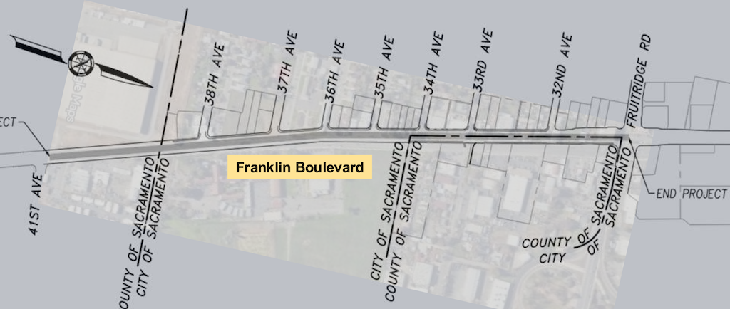
The extent of this Phase 3 project is Fruitridge Road to the county line just beyond 38th Avenue, shown below. The southern part of the project (to the left) is in the city, and the northern part (to the right) is shared city and county, but the city is taking responsibility for the entire project.
I note four areas of concern.
One: RRFB (Rectangular Rapid Flashing Beacon) at 33rd Street. RRFBs have a very low rate of compliance in the City of Sacramento, in part because we have among the worst drivers in the state. The installation here includes two beacons, one on the post, and another on an overhead mast arm. This format may slightly increase compliance, but the city has not demonstrated that it increases compliance enough to be safe for people crossing here. The city knows that existing RRFB locations are not safe, but continues to specify them, against the advice of transportation advocates. Either there should be a pedestrian hybrid signal at this location, or it should not be highlighted as a safe crossing, because it is not. Of course every intersection has a crosswalk, whether marked or unmarked, but the presence of a marked crosswalk with RRFB signal implies a level of safety that does not exist.
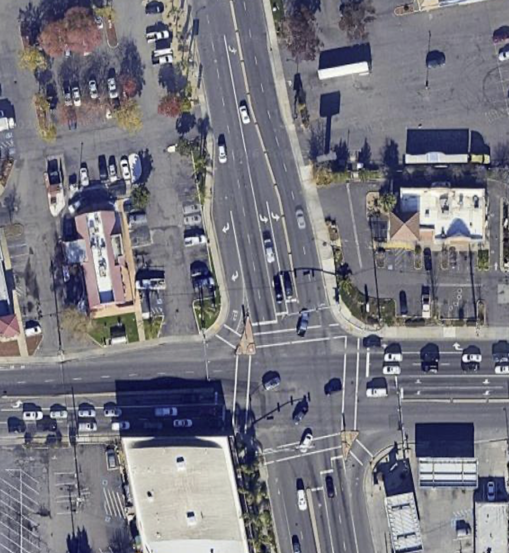
Two: Flared intersection at Fruitridge. The flared intersection of Franklin Blvd southbound at Fruitridge, which I criticized in my previous post as being unsafe for all users, is proposed to be duplicated south of the intersection in this Phase 3. The Google map overview is below. North of Fruitridge, the configuration has changed somewhat. South of Fruitridge, it is as shown, with two lanes southbound, two lanes northbound, a dedicated left turn lane, and a dedicated right turn lane which is a free-right with no traffic control whatsoever.
Google map of Franklin – Fruitridge intersection
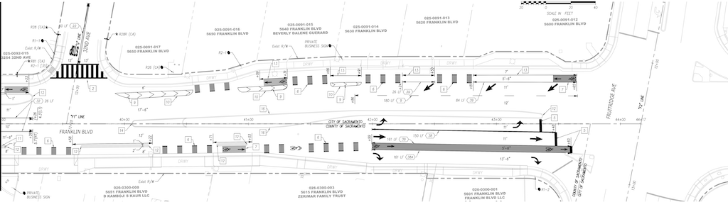
The design diagram for Franklin at Fruitridge is below. It shows some improvement, with only one lane northbound, but is otherwise the same. Two lanes southbound, requiring a merge that could be avoided by making it one lane, as it is on the approach from the north, and one of the lanes is 12 feet, unnecessarily wide. The southbound bike lane is 5.5 feet, too narrow, and does eventually have painted buffer ‘protection’. The dangerous dedicated right turn lane is retained, though it does add a stop sign, which would be widely ignored, and encourages the same driver behavior to look left and ignore anyone in the crosswalk. The lane is 13.5 feet wide, which is ridiculous. The marked northbound bike lane is 5.5 feet, too narrow, between two motor vehicle travel lanes, with no protection whatsoever.
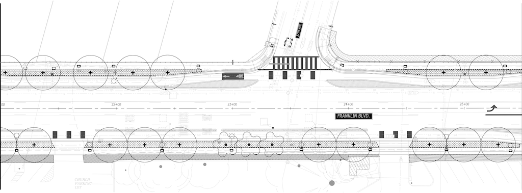
Three: Trees and sidewalk buffers (planting strips). Though sidewalk buffers and trees are being added along about half of the segment, both are missing from the remainder. This is better than it was, but far from the tree canopy/shade that the public has requested. Though I could not find a diagram where the width of the sidewalk buffer was specified, I estimate that they are mostly five feet, but narrower in a few locations. Healthy trees require eight feet or more, so the trees along this section will always be less healthy than they could be. Tree information starts on page 61 of the design diagrams document, with Landscape Planting Legend (LP002), and includes six street sections. A total of 50 trees are indicated, though it is doubtful, given past projects, that all of these will be planted. The diagram below shows the 37th Street section, with more trees than any other.
Franklin-37th Street section, Landscape Planting Plan LP102
Four: Wide concrete bikeway medians. There are a number of locations with very wide concrete medians to separate the bikeway from travel lanes. I’m all in favor of concrete medians, which provide real protection rather than the visual protection of vertical delineators. But a narrow concrete median is just as effective in providing protection as a wide median. In many cases, these medians seem overly wide, as though to simply take up excess space. Though the stamped concrete specified for many of them is slightly better aesthetically than plain concrete, it is still an unnecessary expanse of heat generating and expensive infrastructure. If possible, this width should be reallocated to sidewalks and sidewalk buffers.
I posted on the Fruitridge Road Safety and Mobility Plan (2026-02-21), which was before the first community meeting on March 4, which I attended. There were a number of display boards with details that are not necessarily in other documents, but I did not capture those. A second workshop, on July 6, which presented updated concepts based on the first workshop and other outreach, I was not able to attend. The project website has a number of documents of interest, including all those that I reference below. Note that there is another city project, Fruitridge Road Improvement Project, east from Stockton Blvd to Power Inn Road, that is separate from this project.
The public outreach for Phase 2 is complete, and there is no formal process at this time for public input. However, you have the right as a citizen to email the project lead, Virginia Morgan, VMorgan@cityofsacramento.org.
Overall
The map below shows the corridor, and related transportation projects.
map of Fruitridge Road Safety and Mobility Project
The project extends from Riverside Blvd to on the west to Stockton Blvd on the east. The roadway from Riverside to South Land Park Drive is named Seamas Avenue, which is important if you are looking at details in the documents, but I’ll refer to the entire corridor as Fruitridge Road. The section from Riverside to Freeport Blvd is four lanes, but with fairly low traffic volumes and speeds. The posted speed limit is 35 mph. From Freeport to 24th Street, volume and speeds are higher, and the roadway has frontage roads on south and then north side. The posted speed limit is 40 mph. From 24th all the way to Stockton Blvd, the corridor is mostly commercial, with some residential here and there. Volume and speed are again higher. The posted speed limit is 40 mph, but observed speeds are much higher, particularly in the vicinity of the Hwy 99 interchange, where drivers reach highway speeds at the onramps, and continue highway speeds coming off the off-ramps. The section from east edge of the freeway interchange to Stockton Blvd is mostly within Sacramento County, not the city. This section has paint-only bike lanes, which apparently were added in 2024.
Traffic Violence
The corridor map below shows collisions. As is no surprise, they are concentrated at major intersections, but also occur in between, most likely at side streets or driveways. Few collisions are shown for the Hwy 99 onramps and off-ramps, possibly because this data was not included. Though the interchange is within the city, it is completely controlled by Caltrans and collisions would be reported by CHP, not the city. When I asked the consultants why the collision density was so much higher in the county section than the city section, they speculated that it was because there was so much more commercial activity and driveways in that section.
Sidewalks
With few exceptions, sidewalks throughout the corridor are five feet wide. Though there are problems here and there, including utility poles in the sidewalk, and a gap east of the Del Rio Trail, they are overall in decent condition. The lack of trees along this corridor does reduce sidewalk heaving. Driveways are frequent, particularly between Franklin Blvd and Stockton, including the county section. More than half of the driveways have a steep cross-slope in the sidewalk, not meeting current PROWAG/ADA requirements. Some, mostly within the county section, have been fixed with the ramp down, ramp up solution, which is legal but not optimal. Many of the unmodified driveways present barriers to travel with mobility devices, and discomfort for all walkers. All sidewalks and driveways within the project area should be upgraded to PROWAG compliance. The best way of doing so it to install a sidewalk buffer (which the city calls planting strips) so that the driveway slope in within the buffer, not within the sidewalk.
side-sloped sidewalk at driveway, not PROWAG/ADA compliant (and overly wide driveway)
Sidewalks should be a minimum of six feet wide, with additional width where higher walker use justifies it. Initially, the project proposed to leave almost all of the sidewalks untouched, only widening them where there are bus stops. The new Alternative 2 – Enhanced Improvements, considers but does not promise widening sidewalks along the corridor. More on this below.
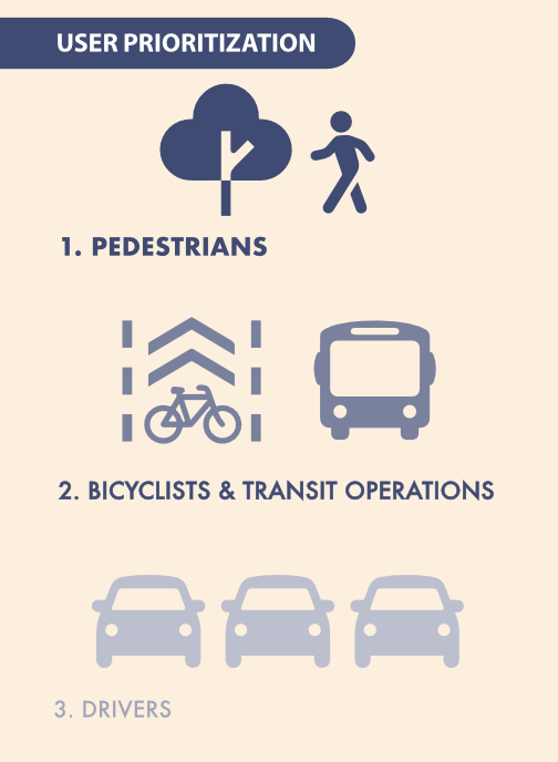
I keep harping on the city’s user prioritization diagram, from the 2024 General Plan, but it is worth remembering for every single project. Not only does it show pedestrians (walkers and rollers) as the top priority, it shows a tree with the walker. The tree is essential for creating a welcoming and safe environment for people walking. But trees are the one feature most neglected in transportation planning and infrastructure. Every city project has resulted in fewer trees than were promised, despite trees being one of the top requests by the public.
Roadway re-allocation
The project plan focuses on lane number reductions and lane width reduction, and the question of whether the eastern Segment 2 from 24th Street to Stockton Blvd will be two lanes (three with center turn lane) or four lanes. I don’t think this is the most important issue, except as re-allocation allows for wider sidewalks and sidewalk buffers. I find that Alternative 2, illustrated below, is the only acceptable design of the three presented. The diagram shows a section without driveways, but frequent, poorly designed driveways are characteristic of much of Segment 2. Only this alternative allows continuous level sidewalks, with driveway ramps in the sidewalk buffer. Though at this stage of planning, the width of the widened sidewalks and new sidewalk buffers is not specified. I believe that sidewalks should be a minimum of six feet, and wider where walkers and rollers are more frequent. Bus stops should have at least eight feet of sidewalk, and most bus stops should have bus shelters and other amenities that are not within that eight feet. Buffers should be a minimum of eight feet, to allow for tree health and growth without sidewalk buckling. The city has been using buffers of 4 to 6 feet on many projects, which is too narrow.
The Phase 2 Design Alternatives document, which I assume must have been the display boards at Workshop 2, does have widths shown for the various segments, but unfortunately, these diagrams do not exactly match the diagrams in the presentation. For example, the presentation Alternative 2, below, indicates widened sidewalks, but the design alternatives document continues to show the existing five foot sidewalks.
Sidewalks should also be continuous across intersections with local streets. These raised crosswalk/sidewalks clearly communicate to drivers that they need to slow, and look, when crossing a sidewalk, that they are guess in the walker space, not the preeminent user. There may be intersections with collector and arterial roadways, and other signalized intersections, where continuous sidewalks/raised crosswalk are appropriate.
Bicycle facilities
Alternative 1 shows paint-only Class 2 bicycle lanes. These are unacceptable on roadways over 30 mph, and with the current speed limits at 35 mph and 40 mph, they are not safe. Unless posted and design speed limits are reduced to 30 mph on the corridor, bicycle facilities must be protected with at a minimum, wide buffers with vertical delimiters, and preferably and safer, concrete medians and curbs. Without width specification, it is unknown whether these facilities will accommodate modern bicycles and riders. But as with all bicycle facilities, the more important issue is how bicycles are accommodated at intersections. The city has not done well with this issue.
Intersections
Intersections are where most collisions occur, and the locations where walkers and bicyclists are most at risk, and most discouraged, but the documents available to date don’t show intersection modifications.
There are two intersection in the corridor that must be significantly modified to make them safe for all users. At Fruitridge Road and Freeport Blvd, the intersection flares to have five westbound lanes, with two dedicated left turn lanes, two through lanes, and one dedicated right turn lane. A crossing distance of 113 feet! Eastbound, four lanes, with one dedicated left turn lane, two through lanes, and one dedicated right turn lane. A crossing distance of 100 feet! There are problems with the design of Freeport Blvd as well.
Fruitridge Rd & Freeport Blvd flared intersection
The intersection of Fruitridge and 24th Street is acceptable, though it could certainly be improved.
The intersection of Fruitridge and Franklin Blvd is unacceptable, with a similar flared design. The free right turn slip lanes from Franklin to Fruitridge are a clear and present danger to all users of the roadway, particularly walkers and bicyclists. These should have been removed as part of the Franklin Blvd Complete Streets project. And they should be removed citywide.
Fruitridge Rd & Franklin Blvd flared intersection
The intersection of Fruitridge Rd and Stockton Blvd is the third problematic intersection, though it isn’t clear to me whether changes will be part of this project, or the future Stockton Blvd Stockton Transportation Enhancement Project. On Fruitridge, it is not as bad as the two preceding intersections, but the intersection is a vast area of pavement, unfriendly and unsafe for walkers and bicyclists.
These flared intersections create large number of conflict points for motor vehicles, and lengthen crossing distances for walkers to unacceptably long distances. Long crossing distances also slow signal cycles due to the longer pedestrian crossing time, frustrating drivers as well. They also encourage drivers to jockey for position at intersections, and accelerate hard to get ahead of others. Though not a common behavior, belligerent drivers also use turn lanes as bypasses for slow traffic in front of them, creating a high level of danger for everyone. The city has, in the past, installed these flared intersections to create stacking space for motor vehicles at signals, but shortening signal cycles can have the same beneficial impact.
I believe intersections should never have dedicated right turn lanes, and particularly, not ones leading to free right turn slip lanes. Right turning drivers can wait their turn with everyone else. Intersections should only have one dedicated left turn lane. Two or more turn lanes lead to motor vehicle conflict on turns, higher speed turns, and inattention by drivers to people in the crosswalk and bicyclists. Whether there are one or two through lanes (never three or more), depends upon the intended design use of the road. Not on existing traffic counts, but on intended use.
Hwy 99
The worst ‘intersection’ of all is the Fruitridge Road & Hwy 99 interchange. This interchange features three high speed onramps from Fruitridge Road to Hwy 99, and three high speed off-ramps onto Fruitridge Road. It is not a true cloverleaf interchange, which would have four of each, but it is bad enough.
On eastbound Fruitridge, the south side, bicycle lanes are dropped, and so are sidewalks. There are ‘no pedestrian’ signs approaching from the west and east. There are no marked crosswalks or pedestrian warning signs or ramps over the two onramps and one off-ramp. The sidewalk on that side is basically an isolated fake. I watched these ramps for some while. Drivers were entering the onramp to Hwy 99 southbound at highway speeds, far over the posted 40 mph speed limit. The off-ramp on northbound onramp were not as bad because they lead to fairly tight turns, and presumably most drivers know that excessive speeds will cause roadway departures.
On westbound Fruitridge, the north side, bicycle lanes are dropped, but there is sort of a sidewalk. There are sidewalk ramps to unmarked crossings of the one onramp and two off-ramps. There are even pedestrian crossing signs at each, and the west off-ramp, even added yield signs, though those may be for merging to Fruitridge, and not for the crosswalk. I watched the west off-ramp for a while. Every driver was exiting at highway speeds, though the posted speed limit is 40 mph.
I believe that all freeway interchanges should have right-angle entry and exits from surface streets, which cause drivers to stop, or at least greatly slow. If a walker or bicyclist got hit at such a ramp, it would be a low speed collision, and probably survivable. For the high speed ramps of this interchange, a collision with walker or bicyclist would almost certainly be fatal. When a city or county want to redesign an interchange to be safe, Caltrans response is almost always: ‘we’ll work with you on the design, but you are going to pay for the infrastructure, 100%’. Caltrans knows that its interchanges are deadly, but has no interest in fixing them. Cities and counties can rarely afford to do so. As for the lack of mapped collisions (see diagram above), I believe that collisions that happen at the exit of the off-ramps and entry of the onramps are considered to be on a state highway, under the jurisdiction of CHP and not Sacramento Police, so don’t show up in the city’s data.
Fruitridge Rd & Hwy 99 interchange
Bus stops
The designs use the phrase ‘Transit stops will need to be designed to accommodate bikeways’, but there are no diagrams or descriptions of what these would look like. This is a very important issue. The optimal bus stop is at a transit boarding island where the bus stops in the travel lane rather than pulling out of traffic. However, other options are possible and may be more compatible with the overall roadway design. An unanswered question.
The Upshot
Segment 1, from Riverside Blvd to Freeport Blvd, at perhaps at far as 24th Street, should be delayed. The traffic on this section is lower volume and lower speed than the rest of the corridor. Though it would be easier to re-allocate roadway width here, it does not have the same safety value. For Segment 2, to the east of 24th Street, and perhaps including the section from Freeport Blvd, the nature of the roadway, driver behavior, conflict points, and adjacent land uses changes completely. This is where the real problem is, and should be the focus of the project.
Hazardous intersections, particularly at Freeport and Franklin, must be fixed in this project, and these intersections are more important than fixing the corridor, because intersections are where the most conflicts occur, and therefore the most collisions. Even if the city fixed only those two intersections, the project would be progress.
Sidewalks for walkers and rollers are the most important aspect of any re-allocation project, of course more important than motor vehicle throughput, and even more important that bicyclists. Only Alternative 2 provide reasonable infrastructure for walkers and rollers. Sidewalks must be a minimum of six feet wide, even in low-use sections, and wider or much wider in heavily used sections. These sidewalk must be shaded by trees, which must be planted at about 30 foot intervals within sidewalk buffers (planting strips) of at least eight feet wide. Of course that means robust irrigation for trees and other plants during the period of establishment.
Wide concrete buffers, of the sort shown in Alternative 1 – Base Improvements, are a waste of concrete. Wide concrete buffers (8.5 feet!) are no more protective of bicyclists than 18 inch buffers, are a waste of project funds, and add to heat island effects of the roadway. The new Franklin Blvd Complete Streets unfortunately has a number of these. Don’t use them!
The city continuously refuses to reduce posted speed limits on reconstructed streets, with their faulty logic that speeds cannot be reduced without a speed study that shows lower 85th percentile speeds. But reconstructed, complete streets are essentially new streets, as though they had been constructed from scratch. The city can, and should, determine an optimal design and posted speed (which should be the same, not the over-engineered forgiving design speed of 10 mph or more over the posted speed). For this project, the design and posted speed should be 30 mph. Designing for slower traffic is even more important than reducing travel lane numbers.
The Broadway Complete Streets project, to reallocate the street from 3rd Street to 24th Street, is underway. I have been walking this section recently, and I see several things that greatly concern me. To be honest, I was not paying much attention when this project went through public review, and attended only one meeting. I had not looked closely at the project documents. The page linked above confuses me. There are no final design documents, yet I have several documents more recent, including one that says final. Did the city unlink these newer documents? Lose them?
It appears from the work I see being done currently, that parking will be preserved along the entire length of the project. While this makes complete sense where there are small businesses, there are also several blocks where there are large buildings that provide off-street parking, or fast food chain restaurants that that have ample off-street parking. Parking can be a good thing, but not when it takes the place of wider sidewalks and sidewalk buffers.
One positive is that vertical curbs are being installed, replacing the rolled curbs that exist along much of the street at this time. But a negative is that apparently curb lines are not being moved as part of the project, meaning that under-width sidewalks and under-width sidewalk buffers will remain so. A diagram from the planning process shows eight foot sidewalks.
diagram of proposed roadway allocation
Here is an actual constructed section, north side between 18th and 19th Streets. The sidewalk is six feet, and a completely useless sidewalk buffer of about 18 inches is included. A sidewalk buffer this narrow cannot provide planting space, and does not provide any physical or visual separation from the street. The street width could have been reallocated to a wider sidewalk, and a sidewalk buffer wide enough to host trees, but it was not.
Broadway narrow sidewalk and narrow buffer new constructionRead More »
I’ve written about existing sidewalk buffers or lack thereof (sidewalk buffer widths), and a solution for areas without sidewalk buffers (street trees in the parking lane), and now on to sidewalk standards. Sidewalk areas are composed of the sidewalk, sidewalk buffer (also called planting strip or furniture zone), and pedestrian scale lighting.
Design criteria:
All new or reconstructed streets will have sidewalks, sidewalk buffers, and pedestrian scale lighting
Reallocated or mitigated streets will have sidewalk buffers added if right-of-way can be reallocated
Sidewalk areas may also include sidewalk-level bicycle facilities
Attached sidewalks (sidewalk adjacent to the curb) will not be used for new or reconstructed streets
Sidewalk width:
Minimum sidewalk width will be six feet in areas of 85% of more residential
Minimum sidewalk width will be eight feet in all other areas
Sidewalks must be completely free of obstructions, encroachments, or driveway aprons into their minimum width
Sidewalks adjacent to and within 1/8 mile of schools will be a minimum of 8 feet; sidewalks used for drop off/pickup will be a minimum of 10 feet
Sidewalk buffer width:
Minimum sidewalk buffer width will be eight feet in order to accommodate a canopy of mature trees; if a lesser width is available, parking areas will be considered for tree placement
Sidewalk buffer may also accommodate street related infrastructure and utilities, street furniture, bike and scooter parking, dining areas, bioswales, and other related uses
Sidewalks will receive priority use of right-of-way; travel and parking lanes, and bike facilities, will be placed in remaining right-of-way
Bus stop amenities will not be placed within the sidewalk minimum width; the sidewalk buffer may serve as clear sidewalk abutting the curb, with appropriate design and transition; transit amenities may also be placed on transit islands away from the sidewalk and sidewalk buffer
Sidewalks will be continuous over driveways and alleys, without interruption of design or materials
Pedestrian scale lighting will be provided along the street length; motor vehicle scale lighting will not be considered sufficient; intersections and crosswalks may be lit with motor vehicle scale lighting
Design diagrams:
Sidewalks of six or eight feet, with sidewalk buffers of at least eight feet
Tree planters or wells in the parking lane or curb extensions
Alley entrances and sidewalk crossings of alleys
Driveway crossings of sidewalk, with design indicating walking priority
Bus stop amenities (benches, shelters, etc.) with a sidewalk area clear of encroachment
Transit island diagram here or in the transit section
One of the elements of street design is the width of sidewalk buffers, and how these are presented in design standards. The sidewalk buffer is the area between the curb and the sidewalk. The city calls sidewalk buffers ‘planting strips’, and this is often how they are used, but it is not the only use, and in more urban areas, there are often multiple uses of the sidewalk buffer.
I did a sampling of sidewalk buffer widths in the central city, and a few other parts of Sacramento. I am not claiming any insight into the overall pattern. The city does not have a publicly available database or GIS layer of sidewalk locations and widths, let alone locations and widths of the buffers. I have heard rumors that they are developing one, but I have been hearing that rumor for the last ten years, so I’ve become doubtful.
Typical buffer widths in the central city range from six feet to nine feet, with seven feet being the most common. With huge mature trees, the narrower buffers are too narrow of the trees, and the sidewalks have had to be modified. The photo below shows an example, and these situations are everywhere.
sidewalk narrowed for tree roots, Q St near 14th StRead More »
Given the issues raised by the need for wider bikeways to accommodate wider devices and passing, the topic of my bike lane widths post, I am starting to think more and more about sidewalk-level bikeways, where the bikeway is at the same level as the sidewalk, and not at street level. The street-edge curb provides a good separation between motor vehicles and bicyclists and walkers (not perfect, drivers do ‘accidentally’ or intentional cross curbs). I am concerned that as street-level bikeways become wider, there will be more and more motor vehicle intrusions.
Here are are two diagrams from the Portland Bureau of Transportation (PBOT) Pedestrian Design Guide (2022), page 28. The first uses a tactile divider between the sidewalk and bikeway, the second a buffer similar to the regular sidewalk buffer, but with reduced width due to the greater separation from motor vehicle traffic as compared to regular sidewalks. Note that the street classification system that PBOT uses is interesting, but probably more than is needed in Sacramento for the Street Design Standards update.
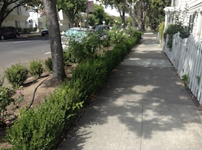
So, given the need for trees to shade sidewalks along Freeport, where do they go? The answer is in the sidewalk buffer or planting strip. At one existing location along Freeport, there is an example of street trees in a sidewalk buffer, where the new Raley’s shopping center is. The photo below is from the photo essay. I don’t know whether the city required the developer to put in sidewalk buffers and wider sidewalks, or whether the developer knew this was the right thing to do and did it on their own. In any case, this is the only part of Freeport that has them, other than a short section along the airport north of Blair Ave.
The one situation in which sidewalk buffers may not be appropriate is where buildings come to the curb in dense retail areas. But there are virtually no instances of this along Freeport. Almost all buildings are set back from the sidewalk a little, or a lot. In several cases there are massive parking lots adjacent to the sidewalk, creating the kind of place where no one wants to be. So buffers and trees at least mitigate the blandness to some degree.
sidewalk buffer and trees along Freeport Blvd at Raley’s
As with any post, I look for example photos and diagrams. So I searched Google for ‘sidewalk buffer’. Lo and behold, the second item is my own post about this! It is experiences like this that make me realize the value of this blog, when other people are using my advocacy work in their advocacy work.
So, so rather than re-write the post, I’ll link to it here: sidewalk buffers. I encourage you to take a read. Trees, and the sidewalk buffers that would allow them, are probably the most important aspect of Freeport Blvd, and the most important topic that the city has neglected.
For a series on walkability, you might think sidewalks would come first, not later. The reason they are not first in the series is that sidewalks, relative to other issues, are in decent shape. Yes, vast areas are missing sidewalks, and in many areas that have them, they are not well maintained. But looking at the whole issue of walking, it is crossing roadways that is most dangerous and unpleasant, not walking along roadways.
I do not believe that low speed, low volume residential streets need sidewalks. It is OK that some have them, and it is OK to require them in new developments (to the degree that it is OK to have new developments, which is to say, this should be irrelevant because there should be no new developments). But to build sidewalks on quiet streets that do not have them is not the best use of funds.
The city has a lot of semi-rural areas without sidewalks. Do they not deserve sidewalks? Where sidewalks would provide a route to key amenities such as grocery stores and schools, sidewalks should be provided, or at least paved asphalt paths adjacent to roadways. Too many people die walking on the shoulders of rural and semi-rural roads, so shoulders are not a solution, there must be either sidewalks or separated paths.
The most important point of all about sidewalks is the first bullet, that it is the responsibility of the city to maintain sidewalks. It is irrational to propose that roadways are maintained by the city, but sidewalks are not. If this belief and legal fabrication persists, Sacramento can never be a walkable city.
Recognizing that sidewalks are an integral part of the transportation network, sidewalk repair will be the responsibility of the city and not of property owners, except where trees owned by property owners, or disturbance, change or widening is initiated by the property owner.
All streets with an ADT over 5000 will have continuous sidewalks of no less than four feet clear path, within five years.
All streets with an ADT over 10,000 will have a continuous sidewalk of not less than six feet clear width, within two years.
All streets with an ADT over 20,000 will have a continuous sidewalk of not less than six feet clear width, with a buffer of not less than six feet, within six years. Parallel multi-use paths can be used to meet this requirement.
Utility poles and other obstructions will not restrict sidewalk width below the minimums above, and where these exist, will either be removed or sidewalks widened. The expense will be borne by the utilities, not city taxpayers.
All sidewalks will be maintained in a state of good repair by the city. Any cracks with a vertical displacement of more than one inch will be fixed within two months. The city will evaluate and implement flexible sidewalks for locations with ongoing tree root heaving issues.
Timely leaf removal from sidewalks will be the responsibility of the property owner, except for sidewalks with a daily use of over 5000, which will be the responsibility of the city.
All development which requires new sidewalks (greenfield development) will fund a maintenance fund so that existing city residents are not financially responsible for sidewalk maintenance on new sidewalks.
Sidewalks will be continuous across alleyways, in concrete and not asphalt. Every alleyway that is reconstructed or repaved will have this implemented.
The purpose of sidewalk buffers, also called planting strips, is to isolate pedestrians from moving motor vehicles, where parking does not provide a sufficient buffer. Sidewalks adjacent to the curb are called attached sidewalks, while sidewalks with a buffer are called detached sidewalks.
Traditionally all residential, collector, and arterial streets had buffers. Retail areas often did not, in order to make getting from the car to the sidewalk more convenient.
Modern suburbs, however, usually eliminated the buffer strip from all streets in order to maximize the area available for development and roadways. Pedestrians do not like to walk next to fast traffic. In part, the elimination of buffers is why there is much less walking in the suburbs. The lack of buffers also makes an area look harsh, with a bland expanse of pavement rather than the welcoming and beautiful strip of nature. The planting strips and their vegetation require maintenance, and responsibility for those areas is another question of responsibility.