Another major happening this last week in Sacramento was the announcement of progress in bringing bike sharing to Sacramento.
Chris Morfas presented to the SACOG Bicycle and Pedestrian Advisory Committee on progress in bike share. Fehr & Peers is writing a business plan for the Sacramento Metropolitan Air Quality Management District. The business plan will include solutions for serving low income people and those without access to credit cards or smartphones (most systems depend on one or both of these to operate).
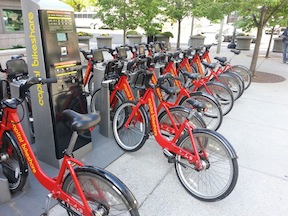
Participants in the annual Cap-to-Cap trip to Washington DC, hosted by Sacramento Metro Chamber, experienced the new and highly successful bike share program there.
The bike share business plan should be completed by mid-summer, and the partners will then seek capital funding from SACOG and possibly private investors. The Sacramento system might be integrated with the bay area systems now being designed, with the Amtrak Capitol Corridor being a logical connection between the two.
See the Bike Share Bulletin_April_2013.
 The chart at right shows the allocation to auto, walking, bicycling, and transit. It is based on the standard that sidewalks add about 3% to the cost of transportation project, and bicycle lanes add about 5%. Reading the project descriptions of the top 20 projects (out of 42 projects), I assigned a percent to ped and bike, and then calculated the project cost. I was pretty liberal, increasing the percentage for projects that actually had some purpose beside widening or extending streets, and only decreasing it when the project didn’t have any significant ped or bike component at all. Transit is even worse. The TPG doesn’t really even address transit, though it should. Transit is usually the best solution to congestion problems, yet it is never identified in the TPG as a solution. And in fact roadway projects can have a negative impact on transit when they clog areas that buses need to move freely, and place cars on top of light rail tracks.


 Reduce speed limit: Reduce speed limits throughout downtown/midtown to 20 mph. Of course simply reducing speed limits does not ensure that actual speeds go down, unless other measures are taken. The removal of three-lane and one-way streets will help a great deal, since these are the streets that most encourage speeding. Other changes suggested below will also slow traffic. I think, however, that the primary change will be a change in attitude, in cultural values. Once a place becomes more livable, people will focus more on being there instead of going through there to somewhere else. I see the whole pace of life in downtown/midtown as being slower, living at the pace of a walker, or even the pace of a casual conversation, rather than at the unnatural pace of a motor vehicle.
 In my
In my 