SacCity Streets for People draft plan

for Matt

Additional posts on the Streets for People Plan will be under category: Streets for People – Active Transportation Network. I encourage you to take a look at Strong SacTown’s series of posts on Street Design Standards. And all of the NACTO Design Guides. And Jeff Speck’s Walkable City and Walkable City Rules. But your own lived experience is just as valuable as the words of the experts, so please join in to support and improve the plan.

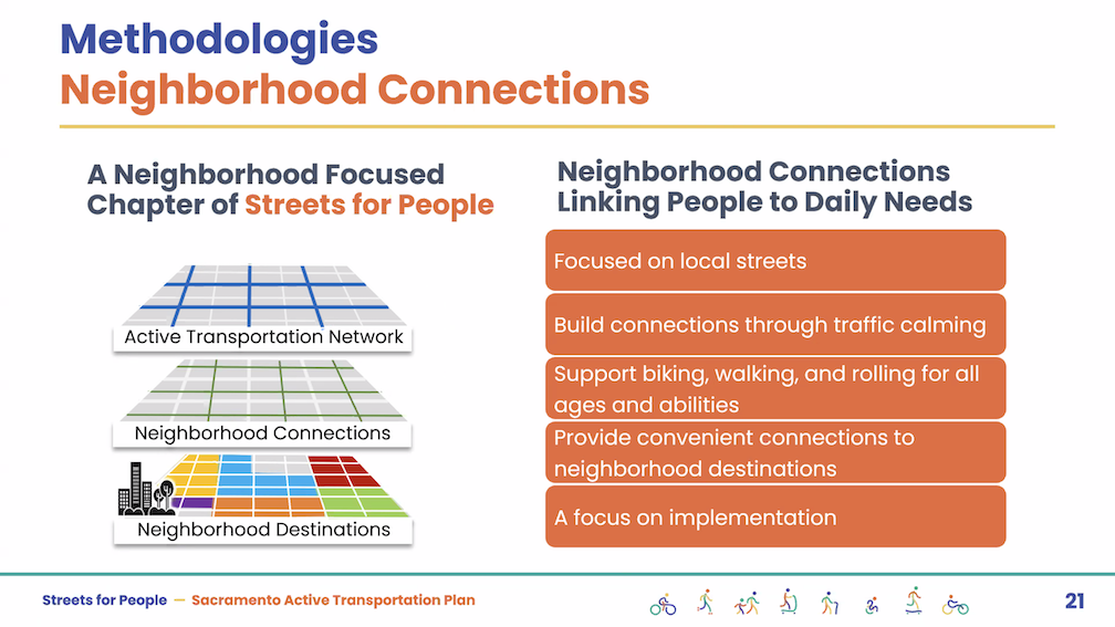
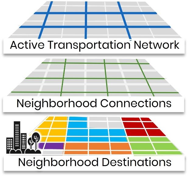
The City of Sacramento Streets for People draft plan has been released. The Streets for People / Active Transportation Plan webpage has more detail. The body of the plan is a little difficult to download there, so it is also available here (57MB pdf). The appendices and related documents are easy to download there (I don’t know why Appendix 5 is missing). A comment about terminology: ‘Streets for People’ refers both to the overall Active Transportation Plan, and to this specific section of the overall plan. The Streets for People: Sacramento’s Active Transportation Plan public draft 2025-03 is the section that covers arterial and major collector streets. Local streets are covered in the Neighborhood Connections Plan (2025-01), which has now be adopted by the city and will be incorporated into the overall plan later this year. The diagram below shows the relationship, with the green neighborhood connections, and the blue ‘active transportation network’ which is the topic of the draft plan.

I have only skimmed the plan, so don’t have comments yet, but since it is out there, I hope that many people will take a look and comment. To the city, mainly, but you can also comment on this blog post. Comments are accepted through April 6. Though the map for gathering geographically related comments is closed, it is still available for viewing. You can submit comments through a form, probably best for general comments that apply to the process or the overall document. You can email city staff directly at StreetsForPeople@cityofsacramento.org. The preferred method for comments is to make comments directly on the pdf, available at https://streetsforpeopledraftplan.altago.cloud/#/, probably best for specific comments on text or graphics. You can also sign up to receive email updates.

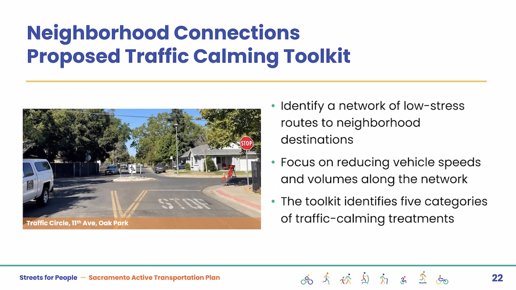
The Neighborhood Connections Plan is great and provides a solid basis for improving both safety comfort level for people walking and bicycling in their neighborhood. However, local streets are not where the majority of crashes occur, certainly not the fatality and severe injury crashes. These occur on arterial and major collector streets, the ones that were designed for motor vehicle movement and convenience. These roadways are too wide, and too fast. Yet many walking and particularly bicycling trips must cross or travel along these dangerous streets. Until these streets are redesigned to not only accommodate but encourage walking and bicycling, most people won’t leave their immediate neighborhood, and will continue to make most trips, even short trips, but motor vehicle. And that is the subject of this draft plan, and why it is so important.


Table of Contents

  • 1 About This Plan
    • What Is Streets for People?
    • Need for a Focused Approach
    • What’s in the Plan?
    • Plan Goals
    • Recent Achievements
  • 2 Walking, Biking, and Rolling in Sacramento Today
    • Building on the Past
    • What the Data Shows
    • Equity
    • Walking and Rolling
    • Biking
    • Safety
    • Comfort
    • Access
    • Sustainability
  • 3 Community Engagement
    • Leading with Equity
    • Community Planning Team
    • Engagement Events
    • What We Heard
  • 4 Recommendations 52
    • Network Recommendations
    • Intersection Recommendations
    • Recommended Policies and Programs
    • Maintenance Considerations
  • 5 Implementation
    • Costs
    • Funding
    • Monitoring and Review
    • Next Steps
  • A Appendices (which are in separate documents, available on the webpage)

Streets for People interactive map

Additional posts on Streets for People Active Transportation Plan are at category: Active Transportation Plan.

The interactive map developed for the Streets for People Active Transportation Plan is available for public input through August 11. The ‘add a route’ and ‘add a point’ options have a free-form entry box, so you can enter anything you would like, but using terms that the city uses, in the visual glossaries (below) or the traffic calming features (below) are more likely to be understood and accepted.

You can comment on the city’s recommendations: “Clicking on a draft network recommendation will launch a pop-up that will provide more information about the recommendation. You can leave a comment, like, or dislike on any recommendation.”

Or you can add your own: “Are there roads or intersections that don’t have a recommendation, but you think should? Use the “Add a route” and “Add a point” buttons below to mark these locations on the map.”

The interactive map offers visual glossaries for pedestrian infrastructure and classes of bikeways. Since you can’t have these glossaries open at the same time as the map, they are offered as blog posts and pdf documents by Getting Around Sacramento.

Traffic Calming Features

The City of Sacramento has added the Neighborhood Connections Story Board to the Streets for People Active Transportation Plan webpage. The traffic calming tab has 13 features, with photos, brief descriptions, and relative costs. These traffic calming features are meant for local and minor collector streets, not for major collector and arterials streets. See Streets for People traffic calming for the 13 features.

The crowd-sourced entries on the map are concentrated in the central city and north Land Park. We hope that people who walk and bicycle in other parts of the city, particularly the disinvested areas of South Sacramento and North Sacramento, will make suggestions on the map.

Neither the glossaries nor traffic calming features offer fully signalized intersections as a recommendation. Traffic signals regulate motor vehicle flow to some degree, but do not significantly slow traffic nor make streets safer for walkers and bicyclists. Safety is best achieved by slowing the motor vehicles through street redesign.

The ‘bicycle routes’ / sharrows option in the Visual Glossary of Classes of Bikeways has been misused by Sacramento and many other cities/counties/Caltrans by placing them on high volume and high speed roadways, in lieu of creating safer bicycle facilities. Their use should be strictly limited, and most existing locations should be converted to higher quality bicycle facilities.

Streets for People virtual slides

Additional posts on Streets for People Active Transportation Plan are at category: Active Transportation Plan.

The City of Sacramento held the Streets for People Citywide Virtual Workshop #1 yesterday. Though the city may eventually post the slideshow, it is not on the program page Streets for People Active Transportation Plan yet, so I’m posting them here. These are low-ish resolution screen captures, so you won’t be able to see detail in them, but I hope they are still useful to you. I did not capture every single slide, but I hope the ones of interest are here. Of course the slides do not capture the presenter comments that went with each slide, which are important.

The next workshop, Streets for People Citywide Virtual Workshop #2, will be tomorrow, July 11. Please see the program web page for registration link. I assume the presentation will be the same.

The first workshop was poorly attended. I don’t know how many people, but the presenters mentioned several times how few people were on the webinar. My question/comment is that the Traffic Calming tab of the Neighborhood Connections storymap has the best examples of traffic calming measures, with many of the photos local, whereas the visual glossary pedestrian and visual gallery bikeways examples provided as part of the interactive map are of poorer quality, not local, and in a few cases should not be recommended at all. These two sources should use the same examples, where they overlap.

The second workshop will be followed by a series of focus groups for particular neighborhoods or areas of the city, and walk audits in those same areas. I hope that people will participate in one or more of them.

SacCity Active Transportation Plan

The City of Sacramento is in a planning process that will lead to an active transportation plan, called Streets for People. It will replace the somewhat out of date Bicycle Master Plan and the prehistoric Pedestrian Master Plan. Phase 1 involved gathering input and specifics from the community, and resulted in an existing conditions report.

I have, to be honest, not participated in this process nor posted anything about it. Well, here you go! I’ll look more closely, and no doubt have things to say. Soon, I hope.