Car free gains?

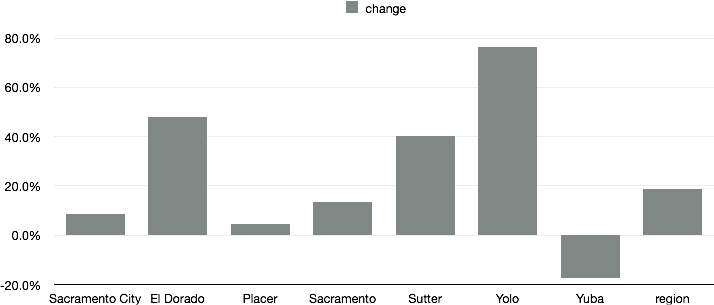
I read with interest the Streetsblog DC post “The American Cities With the Most Growth in Car-Free Households” and wondered about Sacramento. I dove into the American Community Survey, using the same 2012 ACS 1-year and 2007 ACS 1-year data that the research had used to look at the number of car-free households in other cities. Over the period when the national average increased from 8.7 percent share of households without a vehicle to 9.2, the six-county Sacramento region increased from 5.7 to 6.8. Not very impressive, but the change or delta was an impressive 18.8%. Yolo County, probably Davis, led this change with a remarkable 76.2% increase!

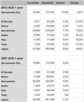
Below is the chart of change from 2007 to 2012, for the City of Sacramento, El Dorado, Placer, Sacramento, Sutter, Yolo and Yuba counties, and the region, which is an average of those six counties. Following the chart are the numbers I retrieved from ACS. If you would like to look for yourself, go to the ACS Advanced Search, and then under Topics select Housing > Occupancy Characteristics > Vehicles Available.

In the blog post, the largest major city increase was Detroit at 5%, and our neighbor San Francisco was sixth at 1.9%.

I’m not quite sure what to make of these numbers. Is there a flaw in my logic? I had to impute the no vehicle households from the total households and percentages for 2007, because the actual number doesn’t seem to be available in the data tables. Were the numbers so small in 2007 that such large changes don’t really mean much? I don’t know. Your thoughts?

change in no vehicles, 2007 to 2012
ACS data
ACS data

Sacramento Riverfront Reconnection, Phase 1

2nd Street extension to Capitol Mall

SACOG in the 2013 funding round allocated $9M to the Riverfront Reconnection project in the City of Sacramento. This phase extends 2nd Street from Old Sacramento to Capitol Mall, providing an easier access to Old Sacramento, and also adds sidewalks to O Street and improves sidewalks and bike lanes on Capitol Mall between 3rd Street and the Tower Bridge. The overall purpose is to create or restore connections between downtown Sacramento and Old Sacramento which were severed by Interstate 5.

Read More »

streetcar moves forward

Steve Cohn, Christopher Cabaldon, Steve Hansen, and other streetcar supporters

The Downtown/Riverfront Streetcar is moving forward. Today there was a demonstration of a Siemens S70 streetcar (made in Sacramento, but unfortunately on its way to Atlanta) at the Township 9 (Richards & 7th St) SacRT light rail station. Mayor Christopher Cabaldon (West Sacramento), Councilmember Steve Cohn (Sacramento) and several others spoke about the future of the streetcar linking West Sacramento and downtown/midtown Sacramento. After the speeches, there was a ride downtown and back so people could see the streetcar in action, and informally discuss the project on the way.

Siemens S70 streetcar at Township 9 station

Yesterday the SACOG (Sacramento Area Council of Governments) board allocated $5M in funding for phase 1 of the project, which is the initial planning, route selection, and environmental review of the system. SACOG is one of the project partners, along with the City of Sacramento, the City of West Sacramento, Sacramento Regional Transit (SacRT), and Yolo County Transit (Yolobus). The remainder of the project costs totaling $12.3M are being provided by the partners. (Details of the SACOG application are at the bottom.)

Read More »

BikeLink

BikeStationBerkeley_tray-racksLast night I used my BikeLink membership to store my bike at the Berkeley BikeStation, which is just two blocks from the Downtown Berkeley BART station. I was wandering around downtown in the late afternoon and early evening before going to a concert, and it was more convenient to be without my bike while walking, and then not having to negotiate to bring it inside at the concert. The BikeStation is a self-service setup, so you can put your bike in and get it out again at any time of day. The adjacent staffed BikeStation has weekday hours, but it doesn’t have to be open to use the storage.

BikeLink is a membership system. Storage costs about 3-5 cents per hour, often less at low-use times, so it is a very reasonable deal. To get started, you have to purchase the card for $20, though, and there is a $5 identification charge on first use. At any rate, $20 buys a lot of bike storage time.

I first wanted to use BikeLink one Sunday in San Francisco when I needed air for my tires and couldn’t find an open bike shop in the part of town I was in. I remembered that there was some sort of bike place at Embarcadero BART station, and so went there, but found it required that I have a card ahead of time. So I signed up and was mailed a card. I used it several weeks later to store my bike there at Embarcadero while attending the Climate Forward SF rally.

BikeLink also has storage lockers at a number of BART stations, other transit locations, and bike-heavy places throughout the bay area. I’ve not used these lockers yet.

BikeLink-card

BikeLink uses the same sort of electronic card as the ClipperCard transit system card which is now in use throughout nearly all of the bay area. Apparently there are discussions about merging the systems, or at least letting BikeLink credit be stored on the ClipperCard, but at the moment, they are separate.

I asked SACOG about whether the new ConnectCard (similar to the ClipperCard), which is being planned for the Sacramento region, would be able to use BikeLink as well. The answer was that the systems are theoretically compatible, but no plans for interoperability are in the works. I’ve heard that just getting all the transportation entities in the Sacramento region to agree on a common card has been a challenge enough.

Cordova Hills on Tuesday

The Sacramento County Board of Supervisors will consider the Cordova Hills sprawl development again on this coming Tuesday, January 29. The issue is agenda item #44, which will not be considered before 2:00PM, but may be considered later if the meeting is behind schedule. I don’t know whether this will again be a marathon meeting going on for hours, but if you wish to comment or observe, it is better to be there on time.

On the request of Phil Serna, SACOG considered the Greenhouse Gas (GHG) implications of the development, with and without a university. You can read the full letter SACOG_MikeMcKeever-on-CordovaHills (1.6MB), but the summary statement on page one is enough:

Cordova Hills will face challenges being included in the next MTP/SCS (to be adopted spring, 2016) largely based on market feasibility considerations, with or without a University. Those challenges are greatest if it is not clear when the University is likely to be built.

On a per capita basis (the relevant performance metric for SB375) Cordova Hills will create higher transportation greenhouse gas emissions relative to other development opportunities in the region, with or without a University. Per capita emissions will be significantly greater without a University than with a University.

An updated Air Quality Mitigation Plan has been provided, with approval from the Sacramento Metropolitan Air Quality Management District, which reflects their midnight conversion to accept the project. The primary added mitigation is the reduction of natural gas combustion through the use of tankless water heaters. As I’ve said before, if it was so easy to achieve these reductions, why were they not included in the project to begin with? [If you want to look at this and other documents (there are now about 72), go to the agenda page and download them. Some are huge.]

There have been several letters and comments in the Sacramento area media since the last hearing, urging that the development be approved because we can trust that the developer will obtain a university. There is no evidence for this, but I guess if you have enough friends in high places, you can make such claims.

I remain absolutely opposed to this project. If we can stop this one, there is hope that there won’t be any more of these sprawl-inducing, urban-services-boundary-busting proposals, but if this one goes through, the floodgates are open and quality of life in Sacramento County for all of us is down the tubes.

SACOG Unmet Transit Needs Hearing

I attended the SACOG final hearing on unmet transit needs. Apparently the process is repeated every year, so this is just the last one for this fiscal year. I spoke, as planned, on the unmet needs of bicyclists on light rail and level boarding with low floor light rail cars. Board member Steve Cohn welcomed me to attend the regular SacRT board meeting to talk about these concerns. He said that SacRT is working on these very issues, but since they haven’t publicized anything yet, I’m not sure what they are thinking and where in the process they are.

Only one other person spoke, mostly about disability access and connectivity between the many transit systems in the region.

I’m not sure whether the lack of testimony indicates that people think all the issues were addressed in the earlier hearings, or whether people didn’t know of the opportunity, or if there is a lack of interest. Though SacRT has clearly improved since the low point of 2010 when the system and service were decimated, there is a long ways to go to get back to base level and then to improve on it.

Fatality trends

The Sacramento Bee today had an article titled Fatal wrecks decline across Sacramento region. I was curious about where the data came from, and asked the author, Phillip Reese. He pointed me to the FARS (Fatality Analysis Reporting System) database. With reluctance, I finally dove in to this database which I’ve long been curious about but afraid of. It is quite hard to use, and it does not allow retrieval of multiple years at once. I compiled a data table of fatalities in the Sacramento region for the last ten years, and the table and graph are below. I used the SACOG region, which includes the six counties of El Dorado, Placer, Sacramento, Sutter, Yolo, and Yuba, so my numbers do not exactly match the four county region used by the Sacramento Bee for the map and 170 number.

The chart shows that there is in fact a downward trend in fatalities in the region, though it is not a consistent decline. Part of the reason 2011 looks good is that 2010 was bad.

Let me say, as I’ve said before, that fatality counts are a mis-measure of roadway safety. The best measure is the rate per vehicle mile traveled (VMT). Injuries are just as important as fatalities because they indicate trends in driver behavior, while fatalities reflect the internal safety of motor vehicles for occupants, and the effectiveness of the emergency medical system in responding to crashes. I will look more at the data, including looking specifically at pedestrians and bicyclists, and the rate for all modes. In meanwhile, here is the data and chart, to be taken with a grain of salt.

chart of traffic fatalities in Sacramento region

Win-Win Transportation Solutions with Todd Litman

WALKSacramento cordially invites you to hear one of the best minds and voices in sustainableplanning today, Todd Litman, founder and leader of the Victoria Transport Policy Institute: (http://www.vtpi.org/). As our region moves forward on implementing the Sustainable Communities Strategy, we need to identify proven “win-win” solutions to the challenges facing us. Please come and hear a fresh, practical yet still visionary perspective.

There are two events on Wednesday, June 13:

  • Noon-1:30 p.m. at SACOG. This event is focused on the transportation and planning professional community, but all are welcome. Go here: http://toddlitman.eventbrite.com/ to register.
  • 6 – 7:30 p.m. at REI. This event is for the community at large and focuses on action for the individual. Register for the evening event at: http://tinyurl.com/ToddLitman

SACOG transportation plan

An interesting SacBee editorial, SACOG sets high bar on transportation plan. SACOG is the Sacramento Area Council of Governments, responsible for overall planning and much of the distribution of transportation funds for the region. The plan funds transit, state highways and local roadways, and pedestrian/bicycle facilities. I’ve reviewed the Metropolitan Transportation Plan 2035 (MTP), and […]