NACTO protected intersection and Sac semi-protected intersection

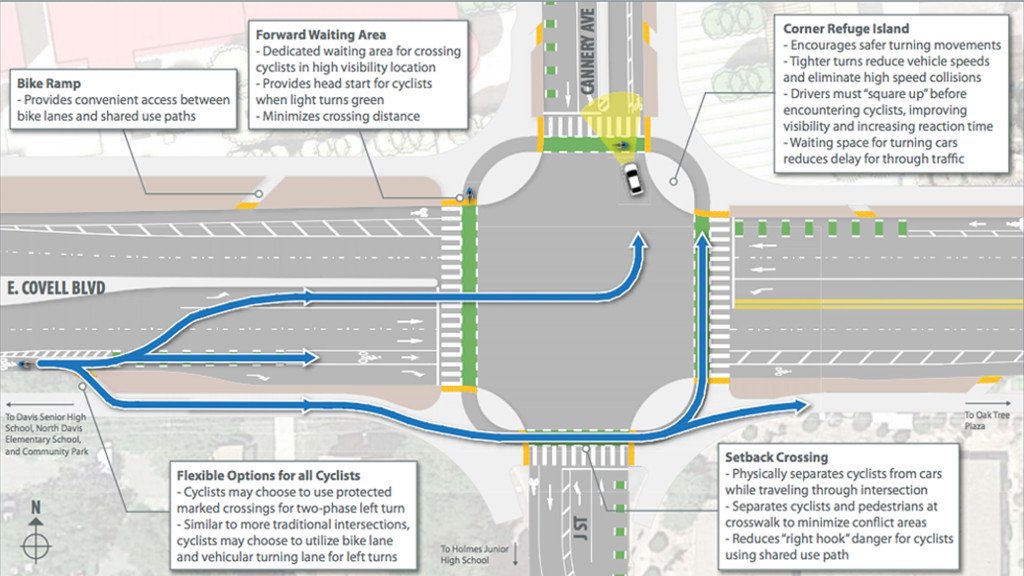
This is Central City Mobility Project update #25.

I have been getting questions from several people about how the turn wedges being installed as part of the Central City Mobility Project are supposed to work. In particular, this applies to all of the concrete wedges, which are at the intersection of the separated bikeways, but applies most of the other wedges as well.

First, the diagram from the Central City Mobility Project design document. This is turn wedge style 3, with concrete turn wedge. The other four styles have speed bumps and vertical delineators.

diagram, Central City Mobility Project, turn wedge style 3

Second, a photo of an actual concrete wedge in place.

photo, concrete turn wedge at 21st St & P St

The issue that has been pointed out by more than one reader is that a motor vehicle driver can also cut between the turn wedge and the curb, to the left of the turn wedge, rather than to the right, as was intended by the design. Wow! That is a flaw. How did this happen?

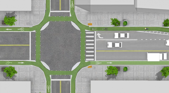
Well, the city has designed partially rather than fully protected intersections. Not only are these protections only on one corner, but they are not designed according to NACTO (National Organization of City Transportation Offices) guidance. Here is the NACTO diagram, from the Protected Intersections page.

NACTO Protection Intersection diagram

What is different? Look at the approach from the left side of the diagram. There is a concrete island, labeled 3, which prevents motor vehicle drivers from cutting through between the turn wedge (‘corner island’ is the NACTO term) and the curb. It is likely that the area labeled 1 would also be a concrete island. This island not only protects bicyclists, but more importantly, protects walkers and shortens the crossing distance. I will include text from the NACTO page below, because the details are really important.

So, how to fix the Sacramento problem? Concrete islands need to be installed in the upstream direction, before the crosswalk. In the case of the photo above, this would be where the photographer is standing. Without such protection, this cannot be considered in any way a protected intersection or separated bikeway (protected bikeway). The radius of the turn wedge is also much greater than the NACTO recommendation, 30 feet rather than less than 18 feet (see second bullet below). So we are back to ‘turn wedges of death‘. I have to say, this is typical of the city, to take a good idea and sort of implement it.

Thank you to the reader who pointed out this design flaw, and caused me to look more closely, and think more closely.

Read More »

Freeport roundabout(s)

Another post on the Freeport Blvd Transportation Plan. See the category Freeport Blvd for other posts.

The city has proposed a roundabout for the intersection of Freeport Blvd and Sutterville Rd E. This is a good location for a roundabout, in part because there is so much space here already that a roundabout would not encroach on other uses.

Notes: I am calling the section of Sutterville Rd to the east of Freeport ‘Sutterville Rd E’ and the section to the west of Freeport ‘Sutterville Rd W’, but these names do not reflect street addresses, since this is all East Sutterville Rd. This post introduces the idea of protected intersections along Freeport, which apparently were not considered by the city in their planning process. For more information on this design, see protected intersections and Davis protected intersection.

First, what it looks like today. As you can see, there is a huge area of wasted space in the intersection

Freeport - Sutterville E intersection existing
Freeport – Sutterville E intersection

Second, the roundabout proposed in the plan.

Freeport - Sutterville E roundabout proposed
Freeport – Sutterville E roundabout proposed, north is to the right
Read More »

Davis protected intersection

The new protected intersection in Davis, the first in the United States to open, has been in the news recently (#Damien Talks Episode 13 – The Davis Planning Department on the Bike Protected Intersection (Streetsblog), This California city just built the country’s first protected intersection for bikes (Vox), It Just Works: Davis Quietly Debuts America’s First Protected Intersection (Streetsblog), Davis Dutch intersection, first ever in U.S., unveiled with no drama (Davis Enterprise), and others). Though it did not initiate the movement towards protected intersections, which have long existed in some form in Europe, Nick Falbo’s Protected Intersection video has popularized the idea in the United States.

Yesterday I spent about an hour looking at the intersection. It was mid-day, so lightly used by bicyclists, pedestrians and motor vehicles. I might have a different impression at a different time of day. I was on my knee scooter, my current method of getting around, so acting as a pedestrian and not a bicyclist. The design is at the intersection of Covell Blvd and J Street/Cannery Row, on the north side of Davis. The intersection was revised because of the major new development north of Covell, The Cannery, which has recently opened but is still being developed. Some photos are on Flickr.

intersection diagram, from Davis Enterprise

With one exception (below), the intersection worked just fine for all modes. Most bicyclists were on Covell headed east or west, and they used the on-street bike lanes. I saw one person use the ramp up to sidewalk and back down, and one bicyclist use the design to turn left from Covell westbound to J southbound. No issues. I also saw a number of pedestrians crossing in various directions. No issues. The signal cycle is slower than it probably needs to be, but, again, that might be different during commute times.

Read More »

Protected Intersections

When I posted on the North 12th Street Complete Street Project, I expressed concern about how the  cycle track to the north would transition to the bike lane to the south, and how bicyclists northbound would access the cycle track. On Wednesday I attended the project open house at City Hall. Preliminary designs presented by the contractor Echelon Transportation Group indicate one possible design for the intersection of 12th Street and C Street, a protected intersection. These conceptual design drawings are not yet available on the North 12th website, so I don’t have a drawing to share here. Comments from the open house and online will be used to revise the concepts, and they should then be available on the website for further review and comment.

The protected intersection is a design new to the United States, and so far not built anywhere in its entirety. The design is fairly common in bicycling friendly countries in Europe. The Protected Intersections for Bicyclists website provides a great video showing how the design works by providing a higher level of safety for bicyclists and pedestrians without much impact on motor vehicles. The design has not yet been included in the NACTO Urban Bikeway Design Guide, but I would guess it soon will be.

protected intersection

The diagram at right shows the general outline of a protected intersection. The intersection at 12th and C would look like the right half of the diagram on the west side, with the almond shaped corner medians, but would not look like the left half on the east side. Bicyclists heading south out of the cycle track would either continue south in the bike lane or use the protected intersection to turn east and then continue south on lower traffic streets. Bicyclists coming from the east would use the protected intersection to get to the west side and the cycle track.