Central City Mobility update

This is Central City Mobility Project update #4.

The repaving of 21st Street between W Street and I Street is complete. The section has been marked with ‘temporary road marker tabs’ (these have various names). The marking is for parking lanes on both sides, of eight to ten feet, and ultra-wide general purpose travel lanes, of at least 16 feet. No bike lanes were marked, though the street previously had marked bike lanes. A typical move on the part of the city and its contractors, to take care of motor vehicle travel and parking, but forget about bicyclists. This is of course temporary, but state and federal law require accommodation of bicyclists in construction zones. No such accommodations was made.

21st St between J St and I St, ultra-wide travel lanes, parking lanes, NO bike lanes

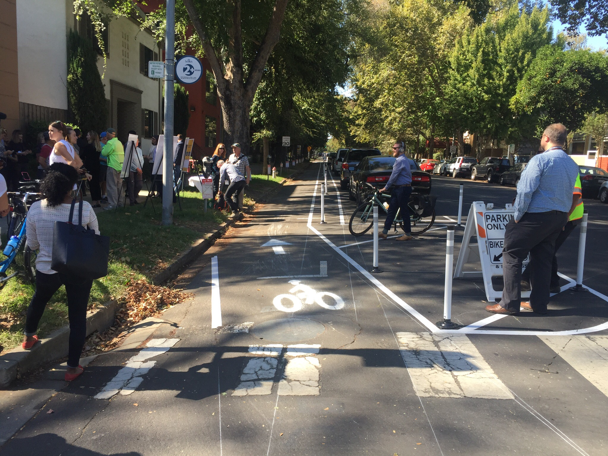
There are temporary paint markings for the first several blocks north of W Street, showing what the paint configuration will be. The parking protected separated bikeway is, as was likely, on the left side because most of this stretch has bus service on the right. The bike area is about seven feet wide. The buffer strip of about three feet wide, and the parking lane is about eight feet wide. The buffer may or may have vertical delineators (soft hit posts) continuously or at conflict points. There is no indication at any location, so far, that there will be hard curbs to actually protect bicyclists when parked cars are not present. For information on why a seven foot bikeway is not sufficient, please see bike lane widths. NACTO recommends at least eight feet.

21st St temporary marking for separated bikeway

As I rode up 21st Street, I noticed that the bus stop is marked in the same way that the parking lane is. I hope this is just a temporary mistake, otherwise there will be parking in the bus stop despite the red curb. The city is still failing to do two things it can to better support transit: 1) install concrete bus pads so that the weight of the bus at the stops does not distort the pavement and cause potholes, and 2) paint the pavement red at each bus stop so as to make it clear that this is a place for buses only, and not private vehicles. And, yes, it would be nice if transit islands were installed so that the bus does not need to pull out of and then into traffic. The city keeps saying that it supports transit, but doesn’t actual do anything to support transit.

21st St bus stop, marked as though it were a parking lane

Lastly, in the category of ‘be careful what you wish for’… I had wondered why the city was not taking advantage of the ADA ramp project to put in curb extensions (bulb-outs) at some critical intersections for walker safety. This afternoon, I noticed that they are putting in curb extensions on the northeast and southeast corner of 19th Street and O Street. Yay? Nay? The problem is that the location of the extensions would extend into the separated bikeway on the left side of 19th Street southbound. The photo below, looking north along 19th Street at O Street, shows the extension under construction. There is supposed to be a curb-adjacent, parking protected separated bikeway here. I assume that bus stops for SacRT Route 62 southbound will be on the right hand side of the street, and the separated bikeway on the left hand side. Is there anyone paying attention? Anyone? Ferris? Anyone?

separated bikeways and bus routes

The City of Sacramento started a design with protected bikeways on streets with significant bus traffic on P Street and Q Street in downtown Sacramento. I live on P Street, so see use of the bikeway on a daily basis. It works OK. P and Q are not heavily biked streets, and the separated bikeways are not heavily used, but they are OK. And actually, P Street doesn’t work well for buses. Since much of the bus traffic is commuter buses, a lot of them over a short period of time, there is often a stack-up of buses blocking traffic and interfering with each other at a stop opposite me on P Street at 13th Street.

Note: I’m using the term separated bikeway here because it is the term in state law, and therefore planning and engineering documents. Most people call these protected bike lanes, or sometimes cycletracks, though the term cycletrack is more commonly used for two-way bike facilities. Use whatever term you’d like!

On Q Street eastbound, the separated bikeway transitions to a bike lane at 14th Street. Since there are bike lanes on both sides of Q Street to the east, a bicyclist a decide where to transition to the right side of the street. This works OK.

On P Street westbound, however, it is a completely different story. The separated bikeway ends at 9th Street. To the west there are no bicycle facilities of any sort. It is a three lane traffic sewer (what I can three or more lane roadways, the purpose of which is solely to flush traffic in and out of downtown). With the construction going on all through downtown, P Street is and has been reduced to two lanes is several places, and with state workers mostly working from home, there is much less traffic in downtown. Nevertheless, the design is fatally flawed. I use the term ‘fatally’ on purpose – it is a design likely to result in bicyclist fatalities.

Read More »

Separated bikeway demo on P St

The City of Sacramento has created a demonstration separated bikeway on P Street (westbound) between 15th and 13th streets. Separated bikeways, also known as protected bike lanes and cycletracks, are becoming common in progressive cities, but this is the first in Sacramanto. Yesterday the city held a “ribbon cutting” on the facility, with Mayor Steinberg and Councilmember Hansen speaking and visibly excited. The demonstration will be there through Friday, then removed. The purpose of the demonstration is to show the public what a separated bikeway looks like and how it works, and gain community feedback on the project. The city wants to install parking protected separated bikeways on portions of P and Q streets, and a buffered separated bikeway on a portion of 10th St (map below), so the demonstration hopefully will lead to permanent installations. 

I was amazed at how quickly drivers adapted to the parking change. Most of the spots were filled with properly parked cars, even though the parking didn’t open until after the morning rush on parking. I was also noted that when the project was already set up for the morning inbound rush hour, there was no congestion on P St. This is the type of project that benefits drivers, bicyclists, and even people parking. 

On of the questions about these facilities is how they interact with transit. The demo was placed on the left (south side westbound) to avoid interacting with buses. However, Route 6 Land Park and Route 38 P/Q Streets are low frequency 60 minute routes that should not strongly influence street allocation. An easy solution to having both separated bikeways and bus stops on the same side of the street is bus boarding islands within the parking lane or buffer, so that the bikeway passes behind the island. 

I encourage you to get out and see, and use, the demo, and then provide your feedback to the city. The city will host an Open House on October 9 from 5-7 p.m. at City Hall. If you can go, please do! I’m sure there will be people there complaining about loss of a lane, and loss of parking (though there is only a slight decrease), and about change in general, so the city needs to hear from enthusiasts (we want it NOW) and thoughtful ideas for how to improve projects and install in more places. More information is available on the CityExpress page, and the Downtown Bikeways Project page


More photos on Flickr: https://www.flickr.com/photos/allisondan/albums/72157686958079110