Note: General information on the Top 20 intersections, with criteria, list, and map, is available in post 1.
I am looking more closely at the Top 20 intersections identified in the City of Sacramento Vision Zero Action Plan Update. Intersections 9 & 13 are North 12th St & North 16th St & Richards Blvd. Though the two intersections are listed separately in the Top 20 list, I have combined them because the intersections are so close to each other that they are essentially one, with both sharing the same design flaws.
Design
Lanes: 12th Street southbound approaching the intersection is five lanes (four through, one right turn). 12th Street is a transition between the high speed freeway (Hwy 160) to the north. Drivers generally have not slowed by the time they reach the intersection. The right turn lane is a wide, sweeping, uncontrolled lane that encourages high speed turns. 16th Street northbound approaching the intersection is six lanes (four through, one right turn, one left turn). The right turn lane is a wide, sweeping, uncontrolled lane that encourages high speed turns. Drivers are already accelerating to freeway speeds at they approach Richard Blvd.
Richards Blvd to the west is five lanes (two through, one right turn, two opposite). The right turn lane is a wide, sweeping, uncontrolled lane that encourages high speed turns. Richards Blvd to the east dead-ends in a self storage facility.
Medians: No medians are present.
Crosswalks: Marked crosswalks are present on the east side and south sides of the intersection, however, they are low-visibility parallel lines, and the crosswalk for 16th Street is poorly maintained.
Bicycle Facilities: No bicyclist facilities are present at this intersection. Bicyclists sometimes use the narrow sidewalk on the freeway to Two River Bike Path, and then a side path to Richards Blvd. A separated two-way bikeway starts at Sunbeam Avenue and Richards Blvd, returning to 12th Street at the Sunbeam intersection. The intended routing is Richards Blvd to Sunbeam Avenue to 12th Street. No bicycle facilities exist on 16th Avenue. No bicycle facilities exist on Richards Blvd to the west of Sunbeam Avenue.
Speed: Richards Blvd has an apparent speed limit of 35 mph, however, no signs are in evidence. 12th Street Street and 16th Street are not in the city’s old speed limit database, and no signs are in evidence. Both 12th Street and 16th Street north of Richards Blvd become a freeway, and speeds on both roadways reflect that design.
The city no longer has a database or map of speed limits, so it is often necessary to look in Google Maps Street View for speed limit signs. The county (and SACOG) have a database, but it does not include the City of Sacramento roadways.
Crashes
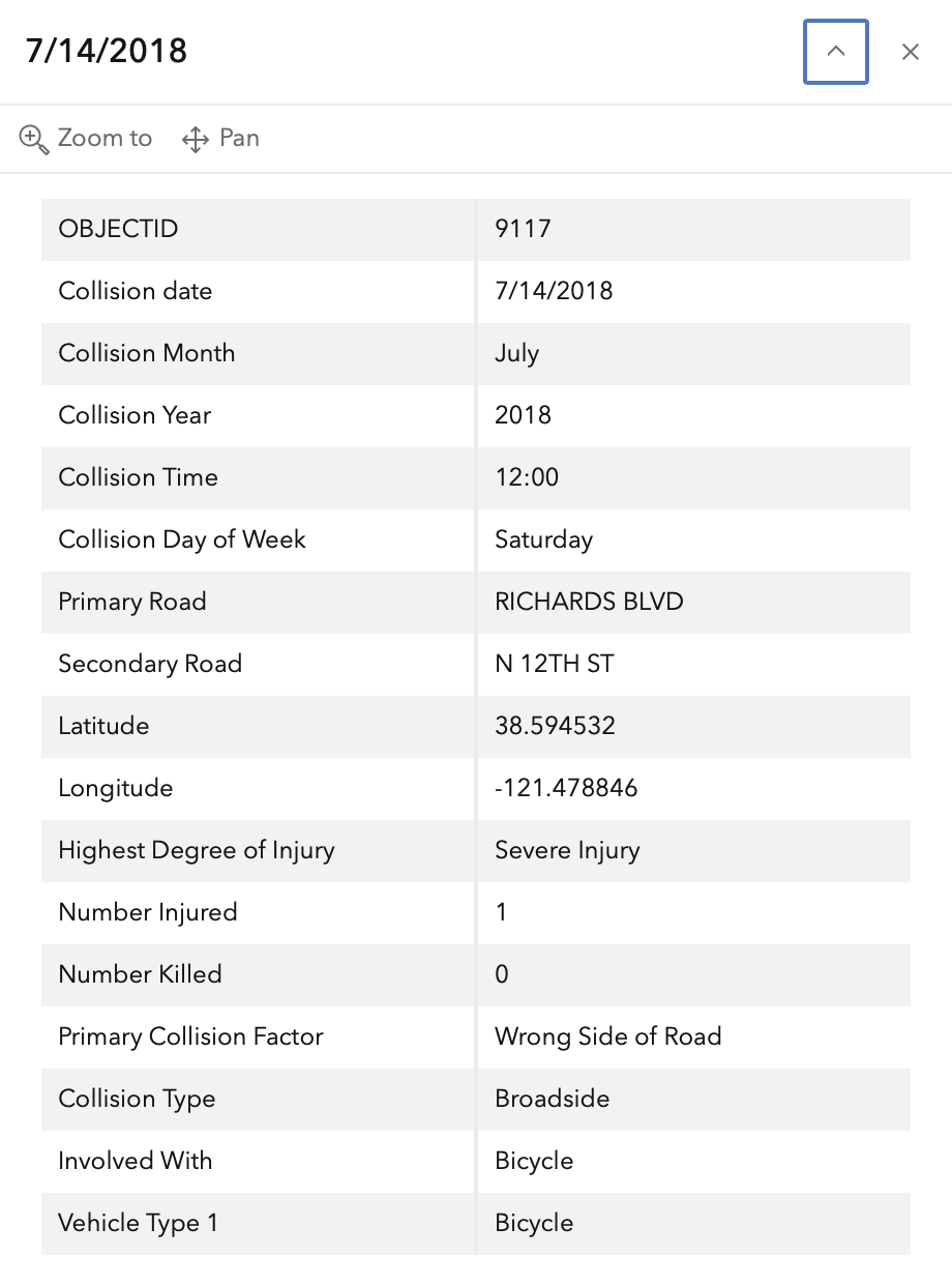
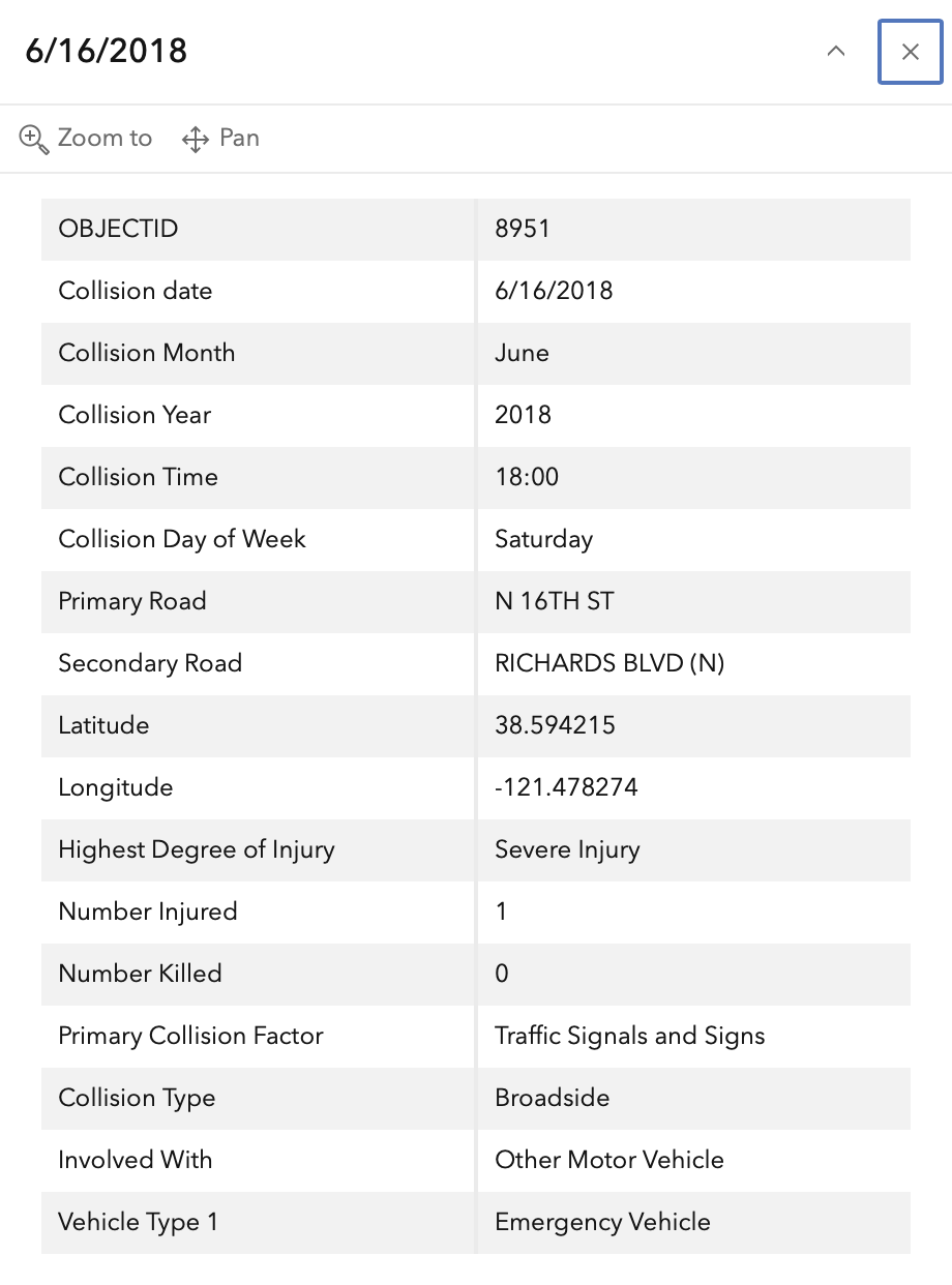
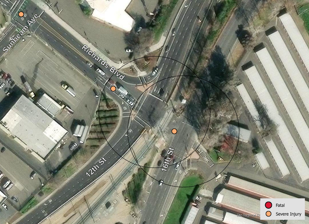
In the 2015 to 2024 period (which is used in the Vision Zero Action Plan Update), there were two severe injuries at this intersection, one with motor vehicle and one with bicyclist. These are mapped below (pdf).
The orange dots are severe injuries (one contains three crashes); the red dots are fatal (none). Together, these are know as KSI = killed or severe injury. ‘Other visible injury’ and ‘complaint of pain’ crashes are not shown on my map, since these are not the focus of Vision Zero, however, there are several of these along Richards Blvd, which you may view in the Crash Dashboard Interactive Map.
Please note that the exact crash locations may not be accurate, as police reports often do not correctly locate crashes. Also note that ‘pedestrian violation’ entry may be false, as police often blame crashes on the person walking when actual responsibility is not clear, or the pedestrian is dead and can’t counter the driver story.
The crash details, available in the Vision Zero Crash Dashboard Interactive Map, are below.