SacCity: VZ intersection 11: Mack Rd & La Mancha Way & Valley Hi Dr

Note: General information on the Top 20 intersections, with criteria, list, and map, is available in post 1. Other posts on Top 20 intersections are available at Tag: Top 20 Intersections.

I am looking more closely at the Top 20 intersections identified in the City of Sacramento Vision Zero Action Plan Update. Intersection 11 is Mack Rd & La Mancha Way & Valley Hi Dr. La Mancha Way is to the north of Mack Road, and Valley Hi Drive is to the south of Mack Road.

Design

Lanes: Mack Road is six lanes west of the intersection (two through, one left turn, one right turn, and two opposite), and seven lanes to the east of the intersection (two through, two left turn, one right turn, and two opposite). La Mancha Way is six lanes (one through, two left turn, one right turn, and two opposite). Valley Hi Drive is eight lanes (one through, two left, one right/through, one right, and three opposite). Total lane count is 27.

Medians: Concrete medians are present on all four legs of the intersection.

Crosswalks: Crosswalks are present on all intersection legs, however, they are low-visibility parallel lines.

Bicycle Facilities: Mack Road has Class 2 bike lanes, with some green paint but no protection. La Mancha Way has fragments of Class 2 bike lanes with many gaps, and no green paint or protection. Valley Hi Drive has no bike facilities at all.

Speed: Mack Road has a posted speed limit of 45 mph (!). La Mancha Way has a posted speed limit of 40 mph. Valley Hi Drive has a posted speed limit of 35 mph. The proximity of Hwy 99 directly to the east undoubtable increases actual speeds over what would normally be found on these roadways.

The city no longer has a database or map of speed limits, so it is often necessary to look in Google Maps Street View for speed limit signs. The county (and SACOG) have a database, but it does not include the City of Sacramento roadways.

Transit: The intersection area is served by SacRT routes 56 Meadowview, 67 Franklin, and 68 Oak Park.

Crashes

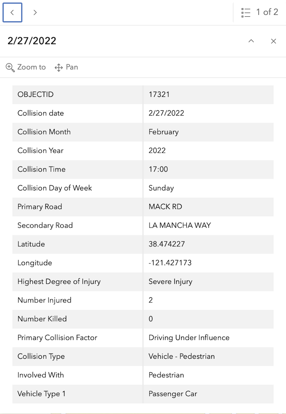
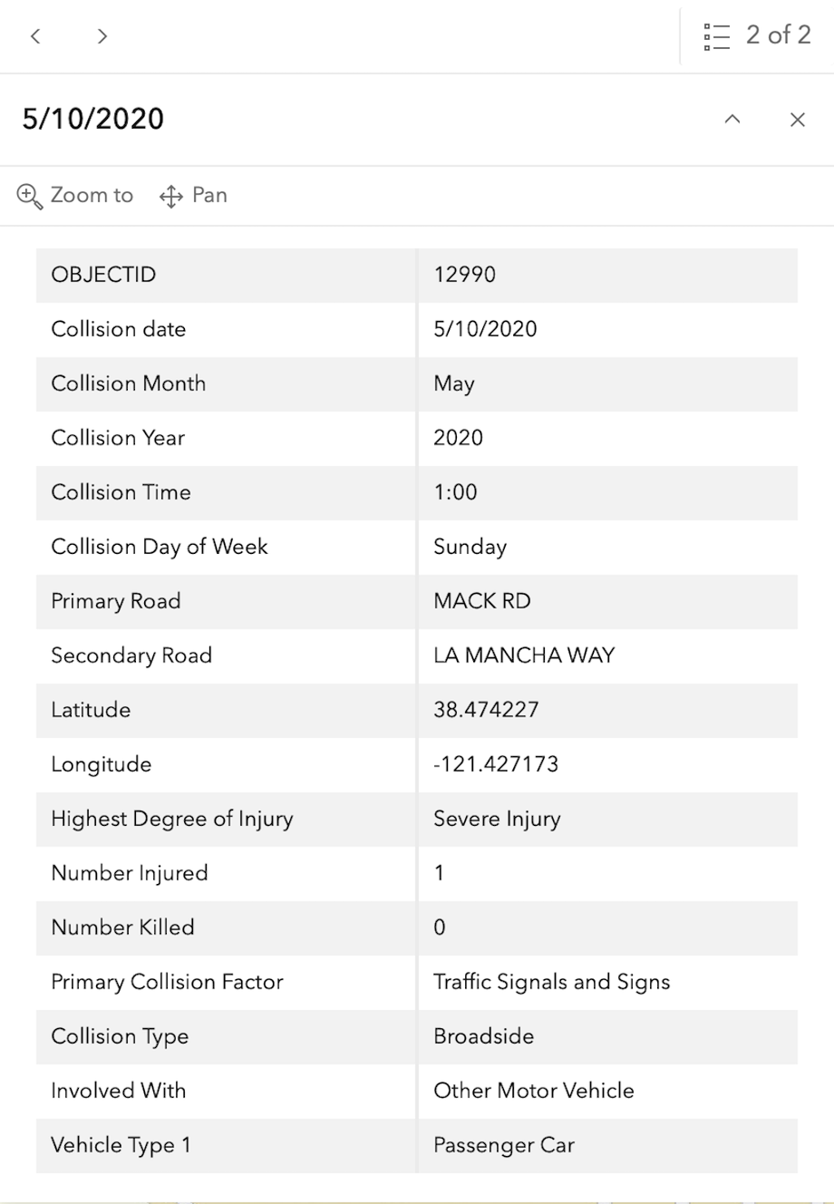
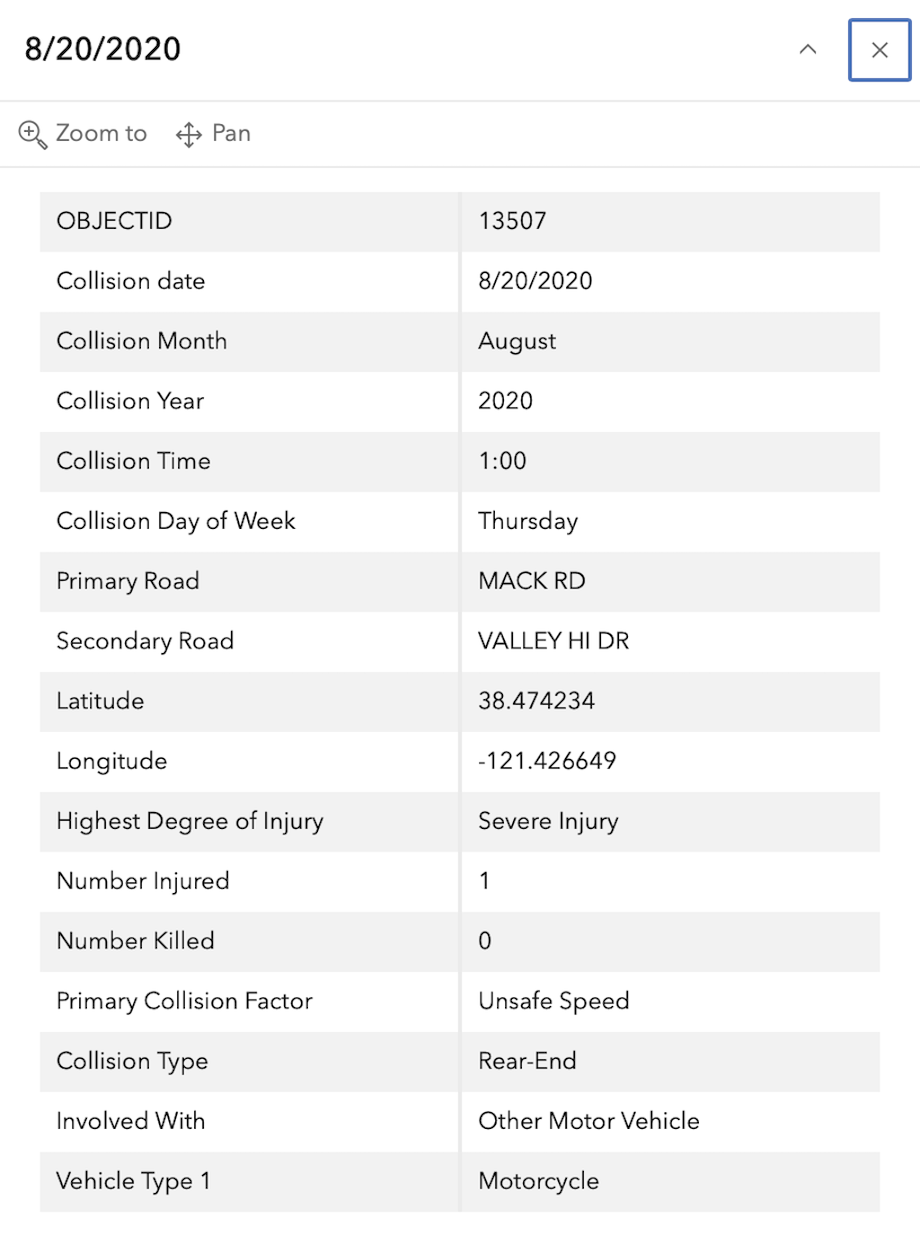
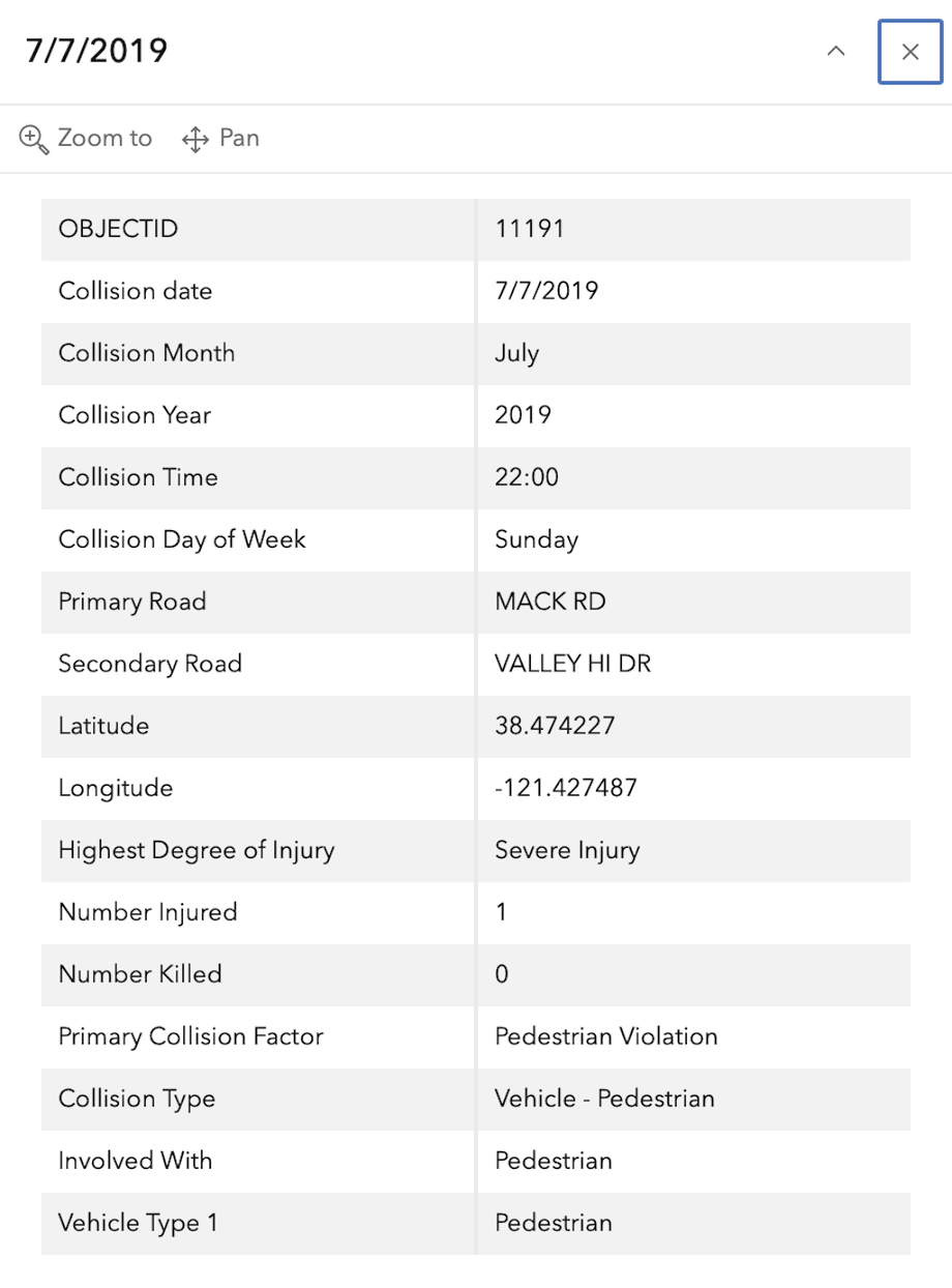
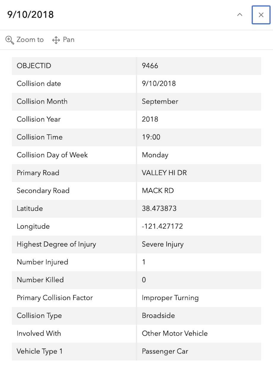
In the 2015 to 2024 period (which is used in the Vision Zero Action Plan Update), there were five severe injuries at this intersection, two with pedestrians and three with motor vehicles. These are mapped below (pdf).

The orange dots are severe injuries (one contains three crashes); the red dots are fatal (none). Together, these are know as KSI = killed or severe injury. ‘Other visible injury’ and ‘complaint of pain’ crashes are not shown on my map, since these are not the focus of Vision Zero, however, there are several of these along Mack Road and Valley Hi Drive, which you may view in the Crash Dashboard Interactive Map.

Please note that the exact crash locations may not be accurate, as police reports often do not correctly locate crashes. Also note that ‘pedestrian violation’ entry may be false, as police often blame crashes on the person walking when actual responsibility is not clear, or the pedestrian is dead and can’t counter the driver story.
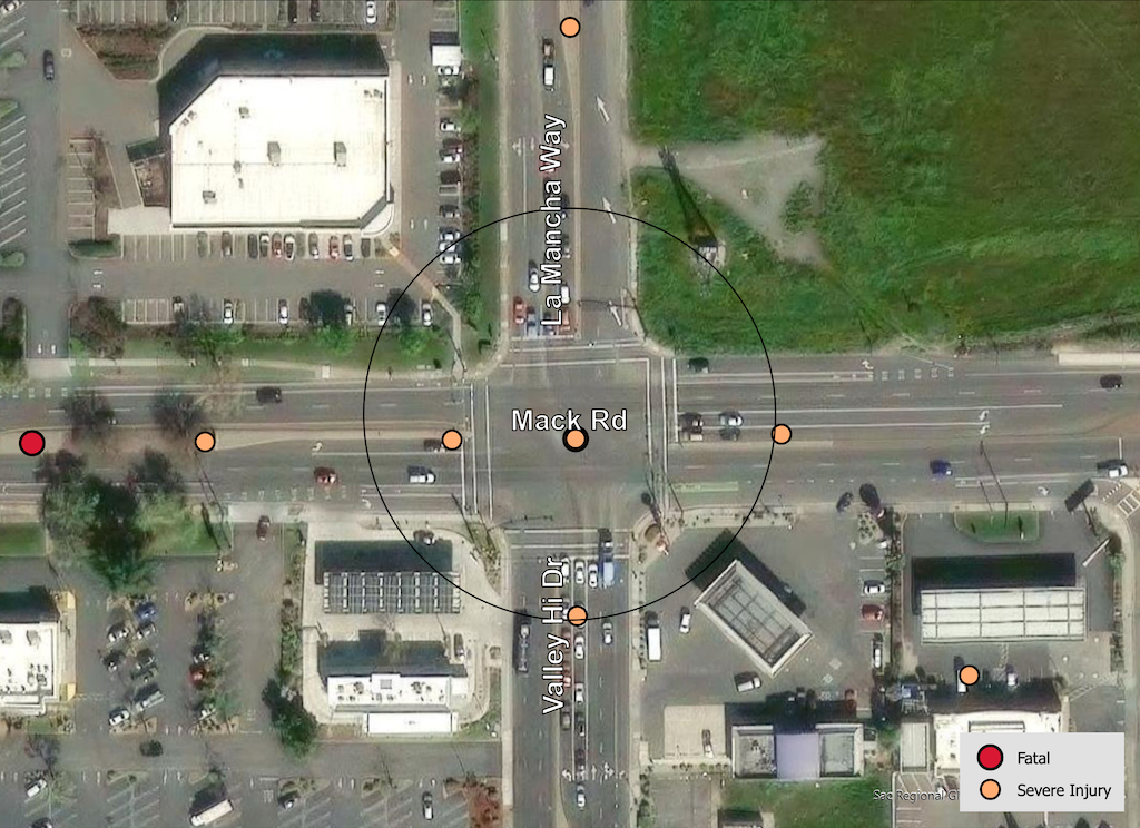
map of Mack Rd & La Mancha Way & Valley Hi Dr
Mack Rd & La Mancha Way & Valley Hi Dr, VZAP update Top 20

The crash details, available in the Vision Zero Crash Dashboard Interactive Map, are below.
SacCity: VZ intersection 10: Albatross Way & El Camino Ave

Note: General information on the Top 20 intersections, with criteria, list, and map, is available in post 1.

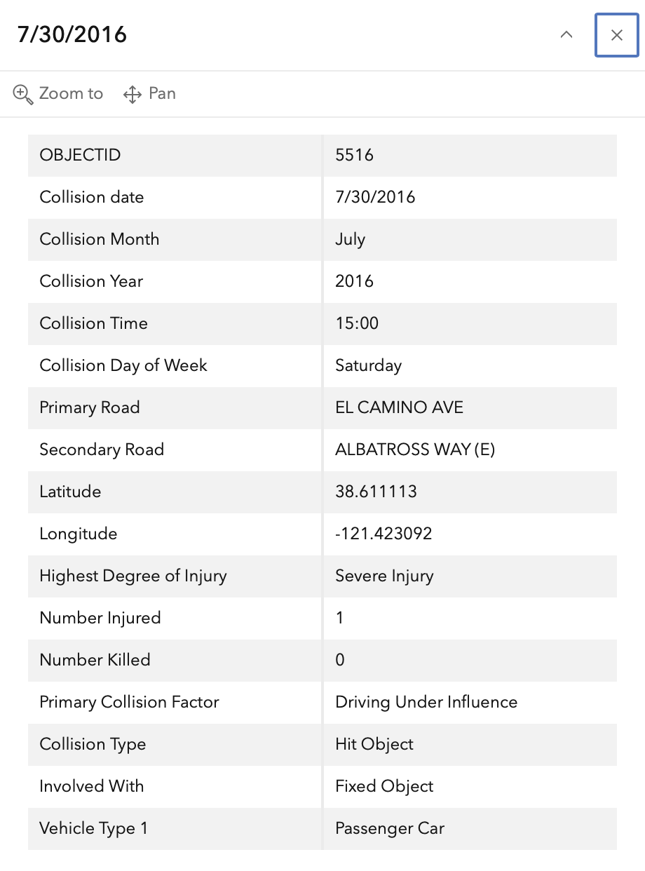
I am looking more closely at the Top 20 intersections identified in the City of Sacramento Vision Zero Action Plan Update. Intersection 10 is Albatross Way & El Camino Ave. This is an offset intersection, with Albatross Avenue to the north of El Camino Ave being offset to the east relative to Albatross Avenue to the south.

Design

Lanes: Albatross Way north of El Camino Avenue is three lanes (one left turn, one right turn, one opposite). Albatross Way south of El Camino Avenue is three lanes (one left turn, one right turn, one opposite). Albatross Way is designated as a local street in functional classification. El Camino Avenue is five lanes (two through, one left turn, two opposite). There are faded white dots to guide the left turns from El Camino Avenue to Albatross Way.

Medians: No medians are present.

Crosswalks: Marked yellow crosswalks (for school) are present on the Albatross Way to the south, Albatross Way to the north, and a single crosswalk over El Camino Avenue aligned with the east side of Albatross Way to the south. There is no crosswalk aligned with the east side of Albatross Way to the north.

Bicycle Facilities: El Camino Avenue has Class 2 bike lanes, but they become advisory approaching the intersection, with no green paint or protection. Albatross Way does not have bicycle facilities.

Speed: Albatross Way, as a local street, has a base speed limit of 25 mph, and is not posted. El Camino Avenue has a designated speed limit of 35 mph, but it does not seem to be posted anywhere near this intersection. An Interstate 80 interchange is adjacent to the west, and likely affects speeds on surface streets.

The city no longer has a database or map of speed limits, so it is often necessary to look in Google Maps Street View for speed limit signs. The county (and SACOG) have a database, but it does not include the City of Sacramento roadways.

Crashes

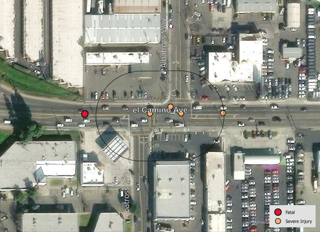
In the 2015 to 2024 period (which is used in the Vision Zero Action Plan Update), there were four severe injuries at this intersection, all with motor vehicles, none with bicyclists or pedestrians. These are mapped below (pdf). There is a fatality just west of the intersection buffer, associated with the northbound Interstate 80 onramp.

The orange dots are severe injuries (one contains three crashes); the red dots are fatal (none). Together, these are know as KSI = killed or severe injury. ‘Other visible injury’ and ‘complaint of pain’ crashes are not shown on my map, since these are not the focus of Vision Zero, however, there are several of these along El Camino Avenue, which you may view in the Crash Dashboard Interactive Map.

Please note that the exact crash locations may not be accurate, as police reports often do not correctly locate crashes. Also note that ‘pedestrian violation’ entry may be false, as police often blame crashes on the person walking when actual responsibility is not clear, or the pedestrian is dead and can’t counter the driver story.

map of Albatross Way & El Camino Ave
Albatross Way & El Camino Ave, VZAP update Top 20

The crash details, available in the Vision Zero Crash Dashboard Interactive Map, are below.
SacCity: VZ intersections 9 & 13: N 12th St & N 16th St & Richards Blvd

Note: General information on the Top 20 intersections, with criteria, list, and map, is available in post 1.

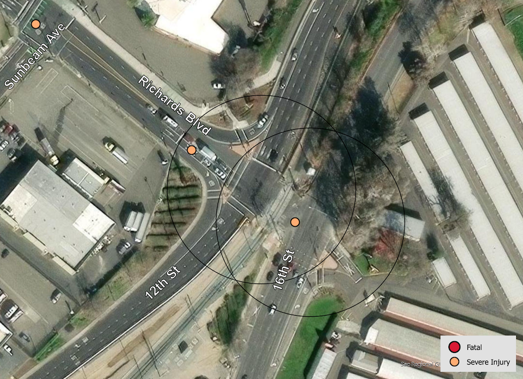
I am looking more closely at the Top 20 intersections identified in the City of Sacramento Vision Zero Action Plan Update. Intersections 9 & 13 are North 12th St & North 16th St & Richards Blvd. Though the two intersections are listed separately in the Top 20 list, I have combined them because the intersections are so close to each other that they are essentially one, with both sharing the same design flaws.

Design

Lanes: 12th Street southbound approaching the intersection is five lanes (four through, one right turn). 12th Street is a transition between the high speed freeway (Hwy 160) to the north. Drivers generally have not slowed by the time they reach the intersection. The right turn lane is a wide, sweeping, uncontrolled lane that encourages high speed turns. 16th Street northbound approaching the intersection is six lanes (four through, one right turn, one left turn). The right turn lane is a wide, sweeping, uncontrolled lane that encourages high speed turns. Drivers are already accelerating to freeway speeds at they approach Richard Blvd.

Richards Blvd to the west is five lanes (two through, one right turn, two opposite). The right turn lane is a wide, sweeping, uncontrolled lane that encourages high speed turns. Richards Blvd to the east dead-ends in a self storage facility.

Medians: No medians are present.

Crosswalks: Marked crosswalks are present on the east side and south sides of the intersection, however, they are low-visibility parallel lines, and the crosswalk for 16th Street is poorly maintained.

Bicycle Facilities: No bicyclist facilities are present at this intersection. Bicyclists sometimes use the narrow sidewalk on the freeway to Two River Bike Path, and then a side path to Richards Blvd. A separated two-way bikeway starts at Sunbeam Avenue and Richards Blvd, returning to 12th Street at the Sunbeam intersection. The intended routing is Richards Blvd to Sunbeam Avenue to 12th Street. No bicycle facilities exist on 16th Avenue. No bicycle facilities exist on Richards Blvd to the west of Sunbeam Avenue.

Speed: Richards Blvd has an apparent speed limit of 35 mph, however, no signs are in evidence. 12th Street Street and 16th Street are not in the city’s old speed limit database, and no signs are in evidence. Both 12th Street and 16th Street north of Richards Blvd become a freeway, and speeds on both roadways reflect that design.

The city no longer has a database or map of speed limits, so it is often necessary to look in Google Maps Street View for speed limit signs. The county (and SACOG) have a database, but it does not include the City of Sacramento roadways.

Crashes

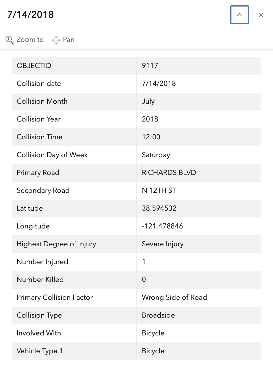
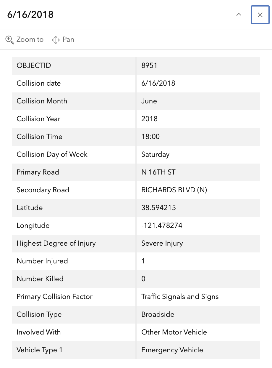
In the 2015 to 2024 period (which is used in the Vision Zero Action Plan Update), there were two severe injuries at this intersection, one with motor vehicle and one with bicyclist. These are mapped below (pdf).

The orange dots are severe injuries (one contains three crashes); the red dots are fatal (none). Together, these are know as KSI = killed or severe injury. ‘Other visible injury’ and ‘complaint of pain’ crashes are not shown on my map, since these are not the focus of Vision Zero, however, there are several of these along Richards Blvd, which you may view in the Crash Dashboard Interactive Map.

Please note that the exact crash locations may not be accurate, as police reports often do not correctly locate crashes. Also note that ‘pedestrian violation’ entry may be false, as police often blame crashes on the person walking when actual responsibility is not clear, or the pedestrian is dead and can’t counter the driver story.

map of 12th St & 16th St & Richards Blvd
12th St & 16th St & Richards Blvd, VZAP update Top 20

The crash details, available in the Vision Zero Crash Dashboard Interactive Map, are below.
SacCity: VZ intersection 8: Florin Rd & 24th St

Note: General information on the Top 20 intersections, with criteria, list, and map, is available in post 1.

I am looking more closely at the Top 20 intersections identified in the City of Sacramento Vision Zero Action Plan Update. Intersection 8 is Florin Rd & 24th St. Note that I have skipped intersection 7, San Juan Rd and Northgate Blvd, because it is unclear why this was included on the Top 20.

Design

Lanes: Florin Road eastbound is five lanes (two through, one left turn, two opposite), and westbound 6 lanes (two through, one left turn, one right turn, and two opposite). 24th Street southbound is 6 lanes (two through, one left turn, one right turn, two opposite), and northbound is five lanes (two through, one left turn, two opposite). 24th Street northbound has an area that might be intended to be a bike lane, but is not signed as such, and otherwise constitutes an extremely wide travel lane of about 36 feet.

Medians: All four legs of the intersection have concrete medians. Florin Road eastbound approaching the intersection has a barrier fence on the median to prevent pedestrian crossing.

Crosswalks: All legs of the intersection have recently upgraded marked crosswalks in the Sacramento pattern.

Bicycle Facilities: Florin Road to the east of the intersection has a new buffered bike lane with vertical delineators on the north side (westbound), and a Class 2 bike lane on the south side (eastbound). None of the other roadways have bicycle facilities.

Speed: Florin Road to the east has a posted speed limit of 40 mph. To the west is unknown because it is not signed. 24th Street has a posted speed limit of 35 mph.

The city no longer has a database or map of speed limits, so it is often necessary to look in Google Maps Street View for speed limit signs. The county (and SACOG) have a database, but it does not include the City of Sacramento roadways.

Crashes

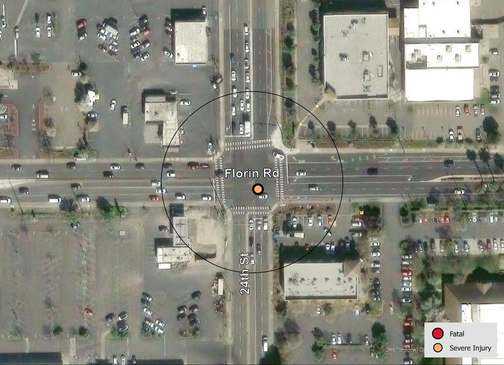
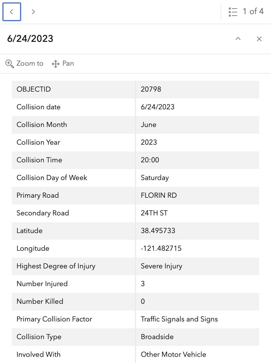
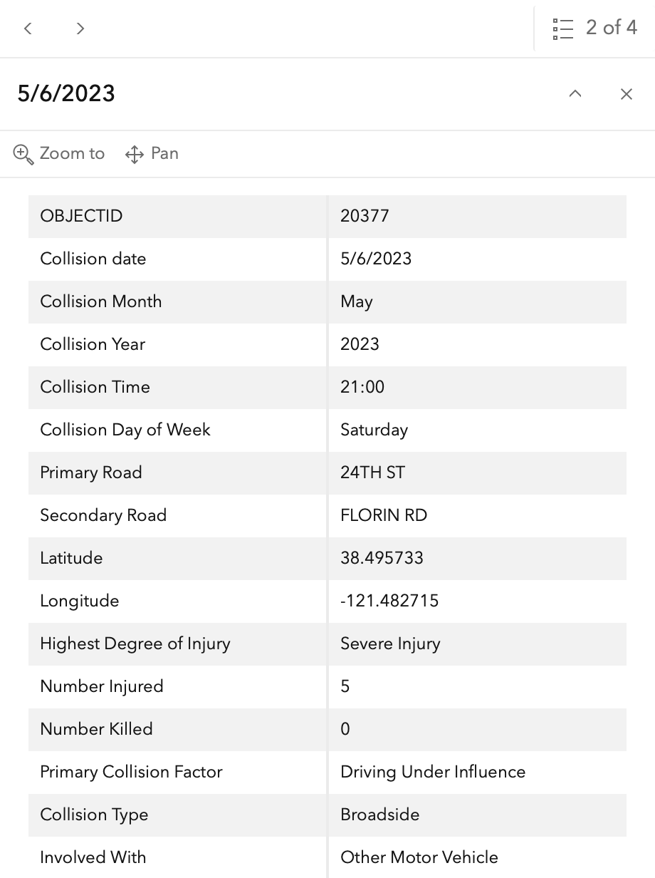
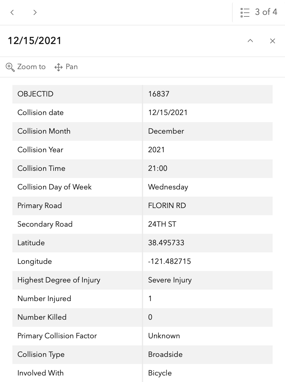
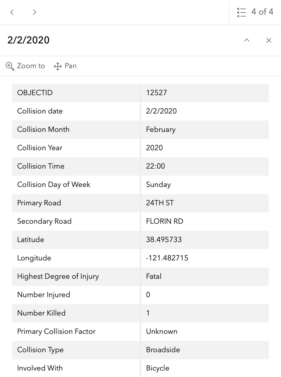
In the 2015 to 2024 period (which is used in the Vision Zero Action Plan Update), there were three severe injuries at this intersection and one fatality, two with motor vehicles and two with with bicyclists, including the fatality. These are mapped below (pdf). One dot contains all four crashes. The fatality is 2/2/2020 (12527).

The orange dots are severe injuries (one contains three crashes); the red dots are fatal (none). Together, these are know as KSI = killed or severe injury. ‘Other visible injury’ and ‘complaint of pain’ crashes are not shown on my map, since these are not the focus of Vision Zero, however, there are quite a number of these at this intersection, particularly on 24th Street, which you may view in the Crash Dashboard Interactive Map.

Please note that the exact crash locations may not be accurate, as police reports often do not correctly locate crashes. Also note that ‘pedestrian violation’ entry may be false, as police often blame crashes on the person walking when actual responsibility is not clear, or the pedestrian is dead and can’t counter the driver story.

map of Florin Ave & 24th St
Florin Ave & 24th St, VZAP update Top 20

The crash details, available in the Vision Zero Crash Dashboard Interactive Map, are below.
SacCity: VZ intersection 6: Northgate Blvd & W El Camino Ave

Note: General information on the Top 20 intersections, with criteria, list, and map, is available in post 1.

I am looking more closely at the Top 20 intersections identified in the City of Sacramento Vision Zero Action Plan Update. Intersection 6 is Northgate Blvd & W El Camino Ave. Note that I have skipped intersection 3, Truxel & Arena, because it is unclear why this was included on the Top 20.

Design

Northgate Blvd is five lanes (two through, one left turn, two opposite). Bike lanes are present but advisory approaching the intersection, with no green paint or protection.

W El Camino Avenue to the west is five lanes (two through, one left turn, two opposite). Bike lane eastbound is advisory approaching the intersection, with no green paint or protection. Westbound, the bike lane is absent for some distance. W El Camino Avenue to the east flares at the intersection to five lanes (two through, one left turn, two opposite). Bike lanes are not present.

Crosswalks are present on all four legs, but are not well maintained, and are low-visibility parallel lines.

Northgate Blvd posted speed limit is 40 mph. W El Camino Ave posted speed limit is 35 mph to the west and 30 mph to the east.

Crashes

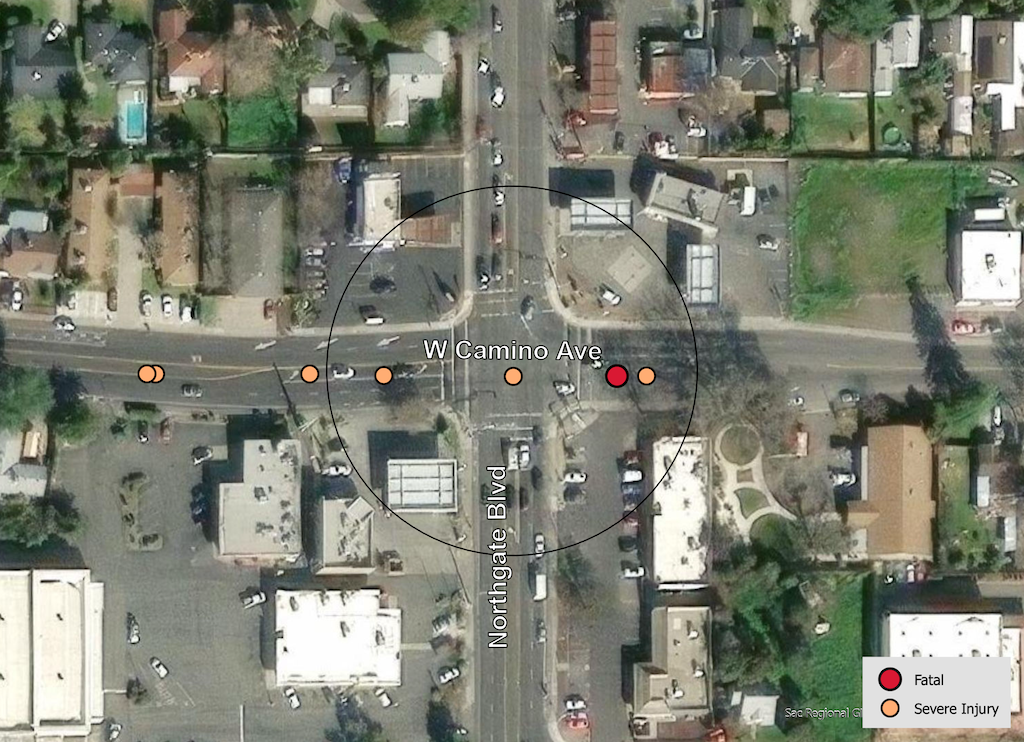
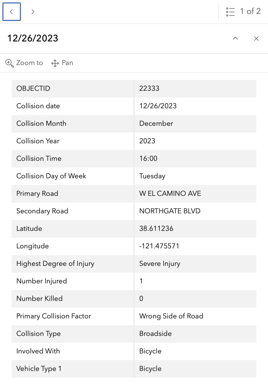
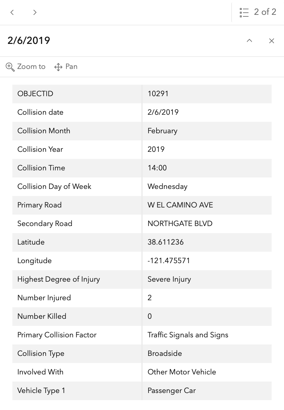
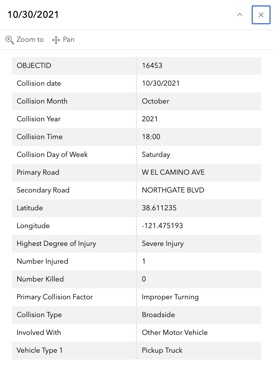
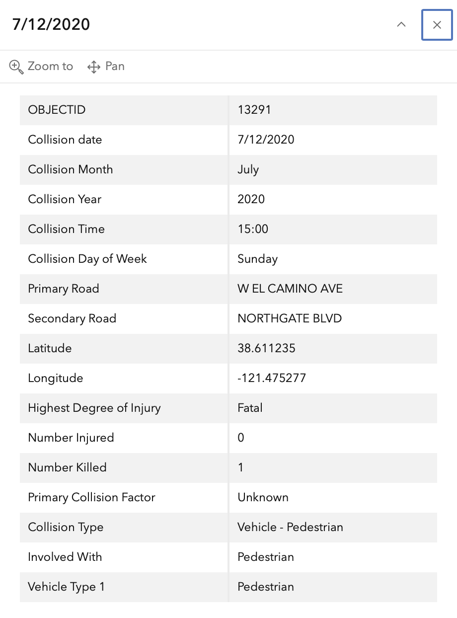
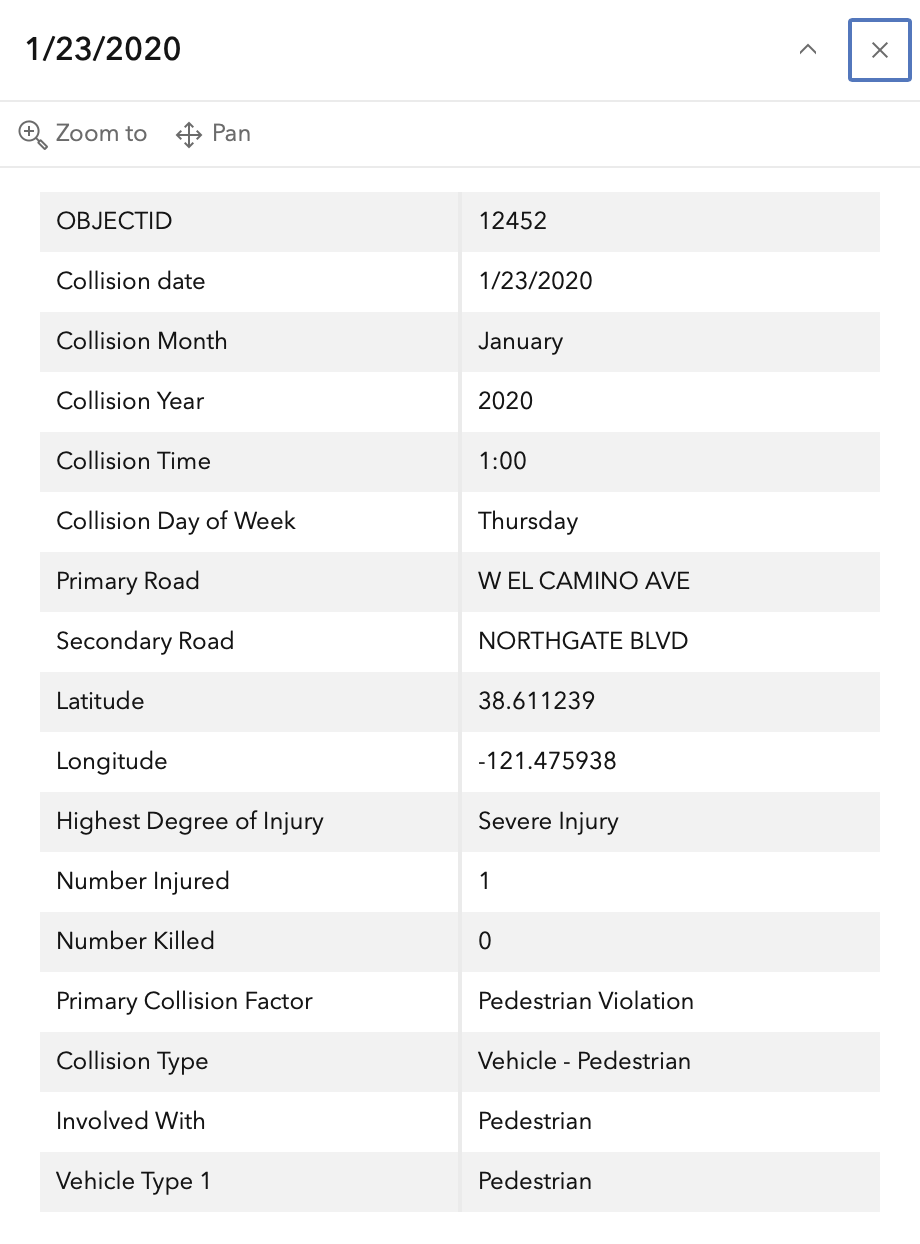
In the 2015 to 2024 period (which is used in the Vision Zero Action Plan Update), there were four severe injuries at this intersection and one fatality, two with motor vehicle, one with bicyclist and two with pedestrian including the fatality are mapped below (pdf). One dot contains two crashes. The fatality is 7/12/2020 (13291) below. Please note that the exact crash locations may not be accurate, as police reports often do not correctly locate crashes. Also note that ‘pedestrian violation’ entry may be false, as police often blame crashes on the person walking when actual responsibility is not clear, or the pedestrian is dead and can’t counter the driver story.

The orange dots are severe injuries (one contains three crashes); the red dots are fatal (none). Together, these are know as KSI = killed or severe injury. ‘Other visible injury’ and ‘complaint of pain’ crashes are not shown on my map, since these are not the focus of Vision Zero, however, there are quite a number of these at this intersection, particularly on Cosumnes River Blvd, which you may view in the Crash Dashboard Interactive Map.

map of Northgate Blvd and W El Camino Ave
Northgate Blvd & W El Camino Ave, VZAP update Top 20

The crash details, available in the Vision Zero Crash Dashboard Interactive Map, are below.
SacCity: VZ intersection 5: DelPaso Blvd & Evergreen St & Lampasas Ave

Note: General information on the Top 20 intersections, with criteria, list, and map, is available in post 1.

I am looking more closely at the Top 20 intersections identified in the City of Sacramento Vision Zero Action Plan Update. Intersection 5 is DelPaso Blvd & Evergreen St & Lampasas Ave Note that I have skipped intersection 3, Truxel & Arena, because it is unclear why this was included on the Top 20.

Design

Del Paso Blvd is 5 lanes (two through, one left turn, and two opposite). Unprotected Class 2 bike lanes are present, but are advisory approaching the intersection with no green paint or protection. Evergreen Street is two lanes. Lampasas Avenue is three lanes (one through, one right turn, one opposing). There are marked crosswalks on all four legs, low visibility parallel lines. There are no concrete medians.

A no parking zone on Lampasas northbound leaves a very wide travel lane of about 22 feet, and a lack of parking on Evergreen northbound leaves a very wide travel lane of about 18 feet. There is a sidewalk gap on the last parcel of Evergreen northbound.

Del Paso Blvd posted speed limit is 35 mph. Evergreen Street posted speed limit is 30 mph, despite being largely residential in nature. Lampasas Avenue posted speed limit is 30 mph.

Crashes

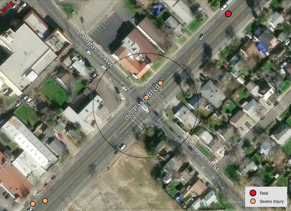
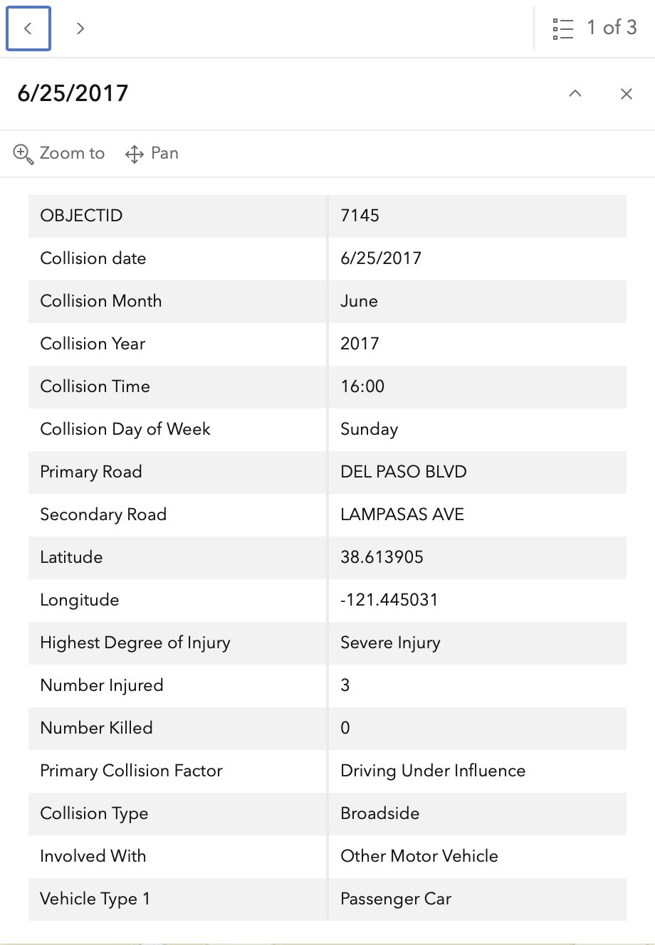
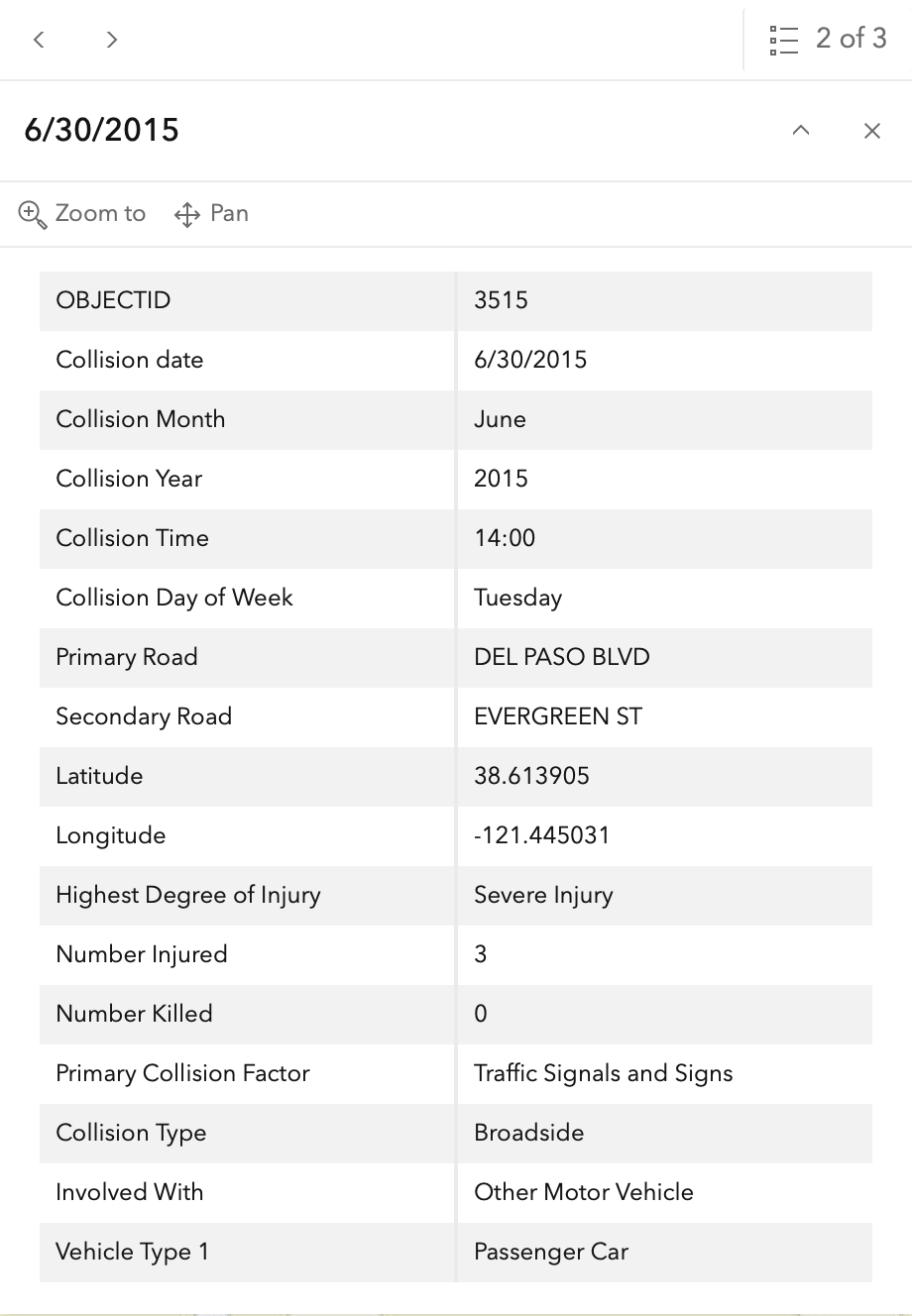
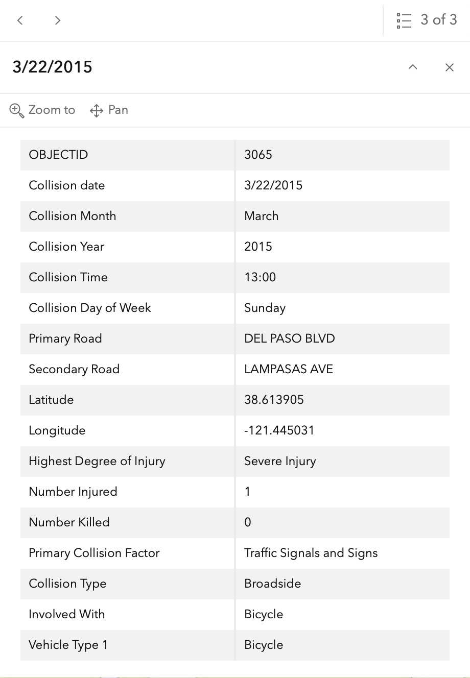
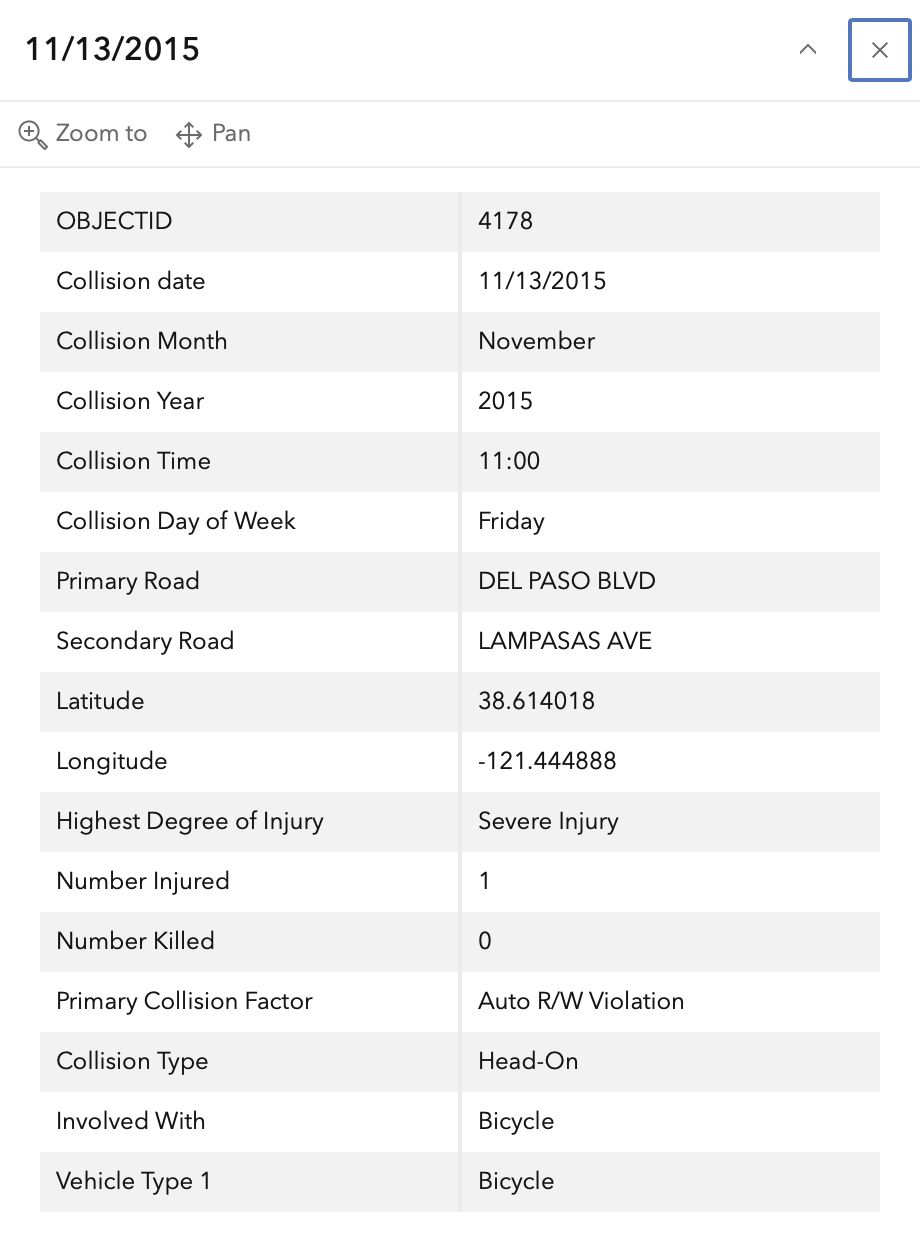
In the 2015 to 2024 period (which is used in the Vision Zero Action Plan Update), there were four severe injuries at this intersection, two with bicyclists and two with motor vehicles, mapped below (pdf). One dot contains three crashes. Please note that the exact crash locations may not be accurate, as police reports often do not correctly locate crashes. Also note that ‘pedestrian violation’ entry may be false, as police often blame crashes on the person walking when actual responsibility is not clear, or the pedestrian is dead and can’t counter the driver story.

The orange dots are severe injuries (one contains three crashes); the red dots are fatal (none). Together, these are know as KSI = killed or severe injury. ‘Other visible injury’ and ‘complaint of pain’ crashes are not shown on my map, since these are not the focus of Vision Zero, however, there are quite a number of these at this intersection, particularly on Cosumnes River Blvd, which you may view in the Crash Dashboard Interactive Map.

map of Del Paso Blvd & Evergreen St & Lampasas Ave
Del Paso Blvd & Evergreen St & Lampasas Ave, VZAP update Top 20

The crash details, available in the Vision Zero Crash Dashboard Interactive Map, are below.
SacCity: VZ intersection 4: Cosumnes River Blvd & Bruceville Rd

Note: General information on the Top 20 intersections, with criteria, list, and map, is available in post 1. Other posts on Top 20 intersections are available at Tag: Top 20 Intersections.

I am looking more closely at the Top 20 intersections identified in the City of Sacramento Vision Zero Action Plan Update. Intersection 4 is Bruceville Rd & Cosumnes River Blvd. Note that I have skipped intersection 3, Truxel & Arena, because it is unclear why this was included on the Top 20.

Design

Lanes: Cosumnes River Blvd eastbound at this intersection is 8 lanes wide (three through, two left turn, one right turn), while westbound is 7 lanes wide (two through, two left turn, and one very wide right turn). Bruceville Road southbound is 7 lanes wide (two through, two left turn, one right turn, and two opposing), while northbound is 9 lanes wide (two through, two left turn, two right turn, and three opposing). The two right turn from Bruceville northbound are a slip lane with signal control, however, drivers frequently ignore signals on slip lanes. Double left turn lanes are a known safety hazard. Total lane count is 31.

Medians: Three legs have concrete medians approaching the intersection, but Cosumnes River Blvd eastbound does not.

Crosswalks: There are crosswalks present on all legs of the intersection, however, they are low-visibility parallel lines.

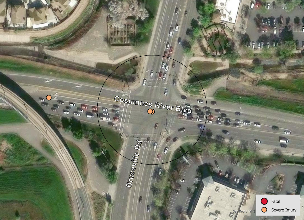
Bicycle Facilities: The roadways have some Class 2 bike lanes, however, they are discontinuous and mostly dropped at intersections. If you look closed at the map below, you can see a motor vehicle using the bike lane fragment on Cosumnes River Blvd eastbound approaching the intersection. No green paint or protection is present.

Speed: The posted speed limit on Cosumnes River Blvd to the west is 50 mph (!), and to the east 45 mph (!), and on Bruceville Road is 40 mph. Both roadways are over-engineered for speed, and are essentially highways.

The overall design shows a strong preference for motor vehicle traffic to and from Cosumnes River College, though the campus is served by light rail Blue Line and a number of buses. Sidewalks are missing on Cosumnes River Blvd eastbound, and the north side of Cosumnes River Blvd westbound.

Transit: The area is served by SacRT routes 56 Meadowview, 67 Franklin, and 68 Oak Park, however, there are not stops close to the intersection. SacRT Blue Line light rail Cosumnes River College station is about 0.3 miles to the south.

Crashes

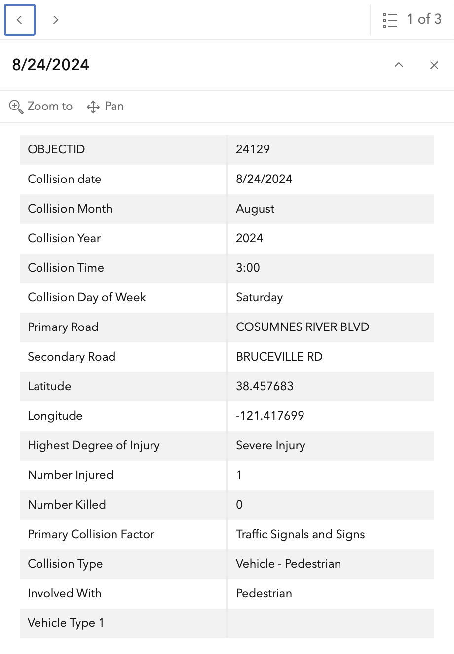
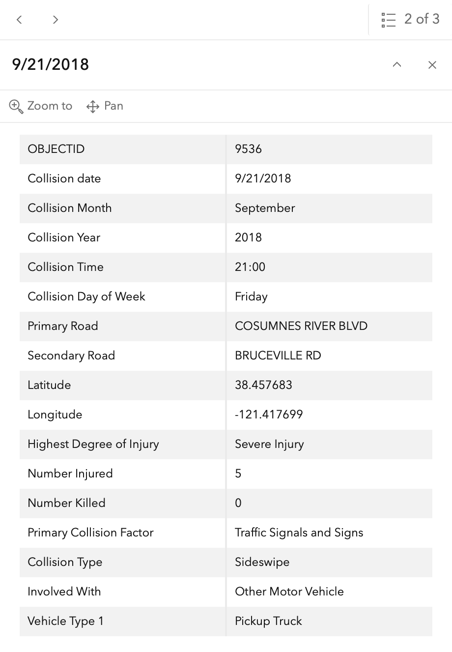
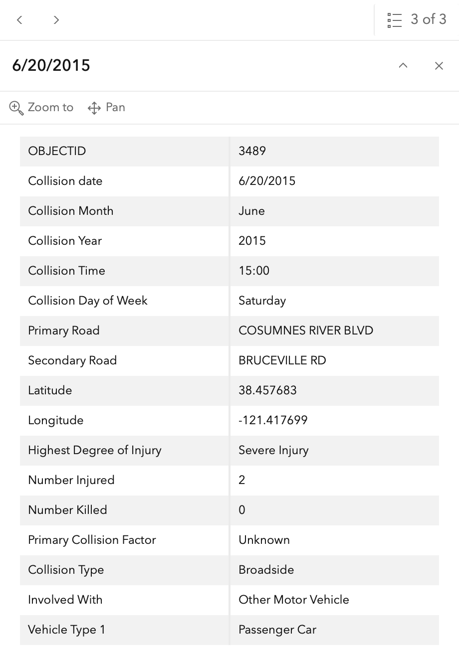
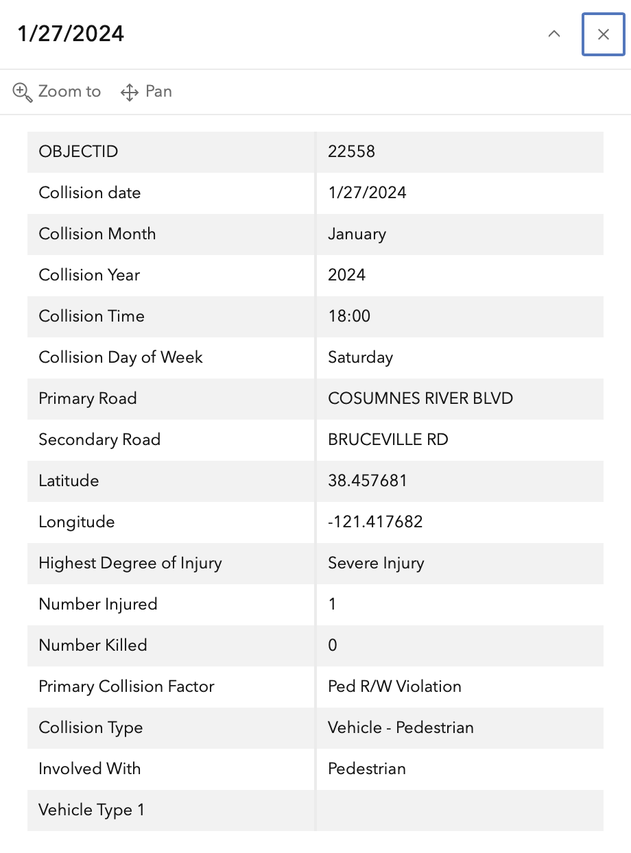
In the 2015 to 2024 period (which is used in the Vision Zero Action Plan Update), there were four severe injuries at this intersection, two with pedestrians and two with motor vehicles, mapped below (pdf). One dot contains three crashes. Please note that the exact crash locations may not be accurate, as police reports often do not correctly locate crashes. Also note that ‘pedestrian violation’ entry may be false, as police often blame crashes on the person walking when actual responsibility is not clear, or the pedestrian is dead and can’t counter the driver story.

The orange dots are severe injuries (one contains three crashes); the red dots are fatal (none). Together, these are know as KSI = killed or severe injury. ‘Other visible injury’ and ‘complaint of pain’ crashes are not shown on my map, since these are not the focus of Vision Zero, however, there are quite a number of these at this intersection, particularly on Cosumnes River Blvd, which you may view in the Crash Dashboard Interactive Map.

Bruceville Rd & Cosumnes River Blvd, VZAP update Top 20

The crash details, available in the Vision Zero Crash Dashboard Interactive Map, are below.
SacCity: VZ intersection 2: Fruitridge Rd & Stockton Blvd

Note: General information on the Top 20 intersections, with criteria, list, and map, is available in post 1. Other posts on Top 20 intersections are available at Tag: Top 20 Intersections.

I am looking more closely at the Top 20 intersections identified in the City of Sacramento Vision Zero Action Plan Update. Intersection 2 is Fruitridge Road and Stockton Blvd.

Design

Lanes: Stockton Blvd at this intersection is 7 lanes wide (two through, two left turn, one right turn, and two opposing). Fruitridge westbound is 5 lanes wide (two through, one left turn, two opposing) while eastbound is 6 lanes wide (two through, one left turn, one right turn, two opposing). Double left turn lanes are a known safety hazard. Total lane count is 25.

Medians: Each leg has medians approaching the intersection.

Crosswalks: All four legs of the intersection have crosswalks, however, they are low-visibility parallel lines.

Bike Facilities: There are Class 2 bike lanes both roadways, but they are discontinuous, become advisory approaching the intersection, and are poorly marked.

Speed: The posted speed limit on Stockton is 35 mph, and on Fruitridge is 40 mph. Both streets are classic suburban sprawl stroads which were designed for, and driven at, much higher speeds than posted.

Transit: The intersection area is served by SacRT route 51 Stockton/Broadway on Stockton, and SacRT route 68 Oak Park on 47th and Stockton.

Crashes

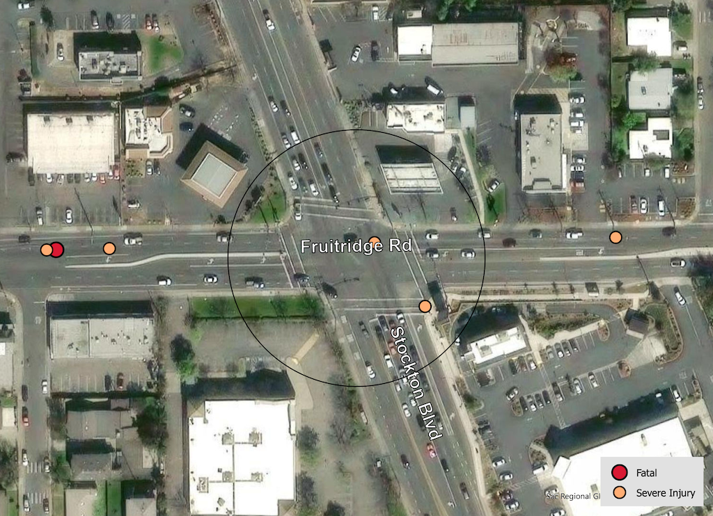
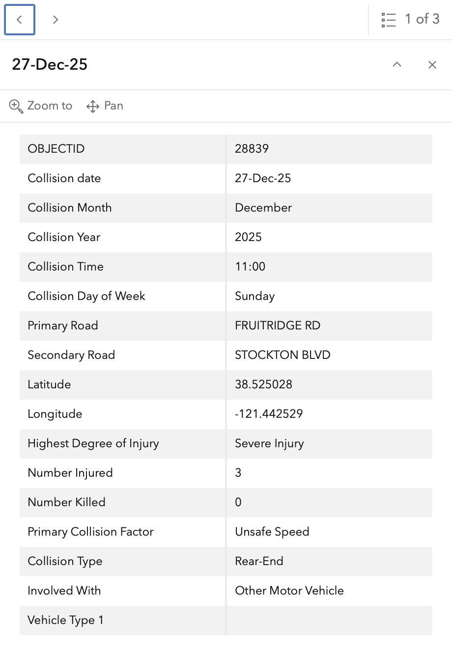
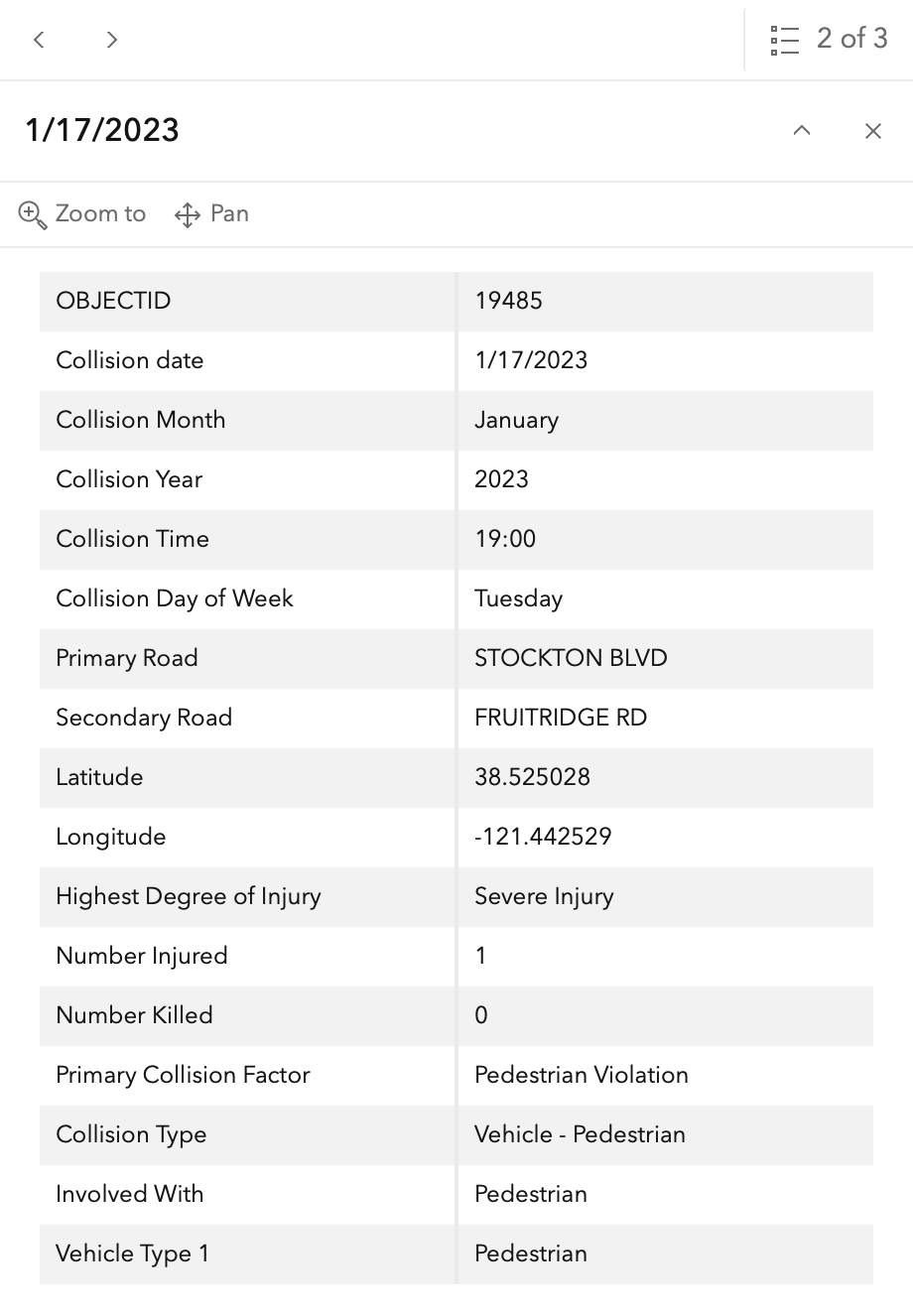
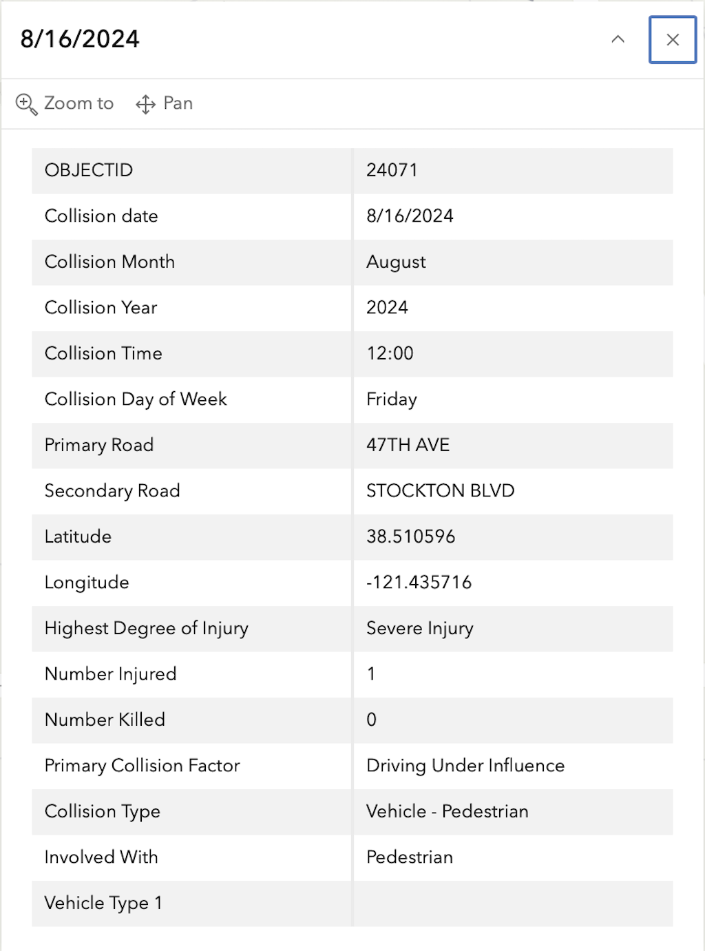
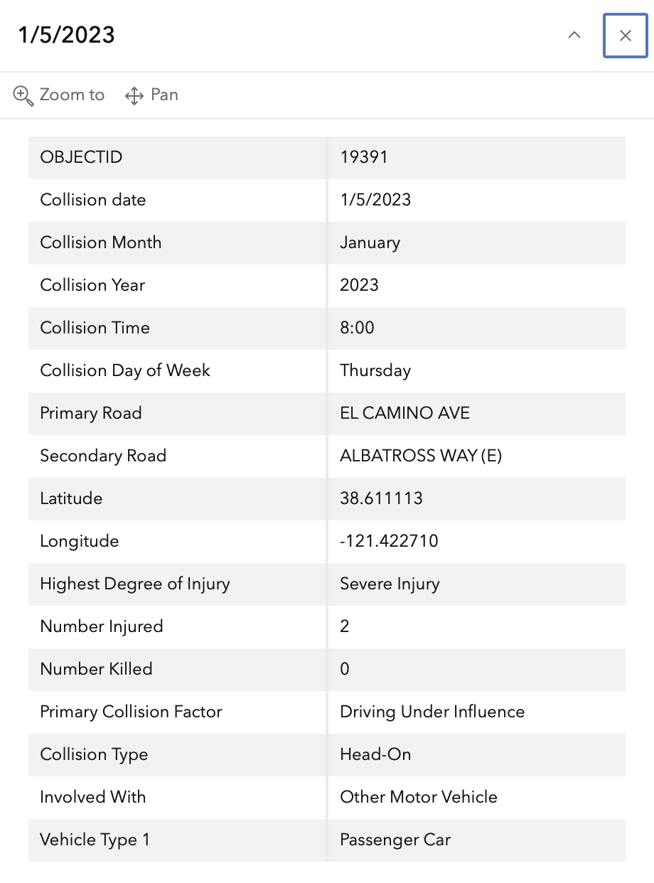
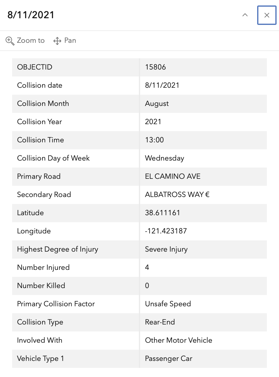
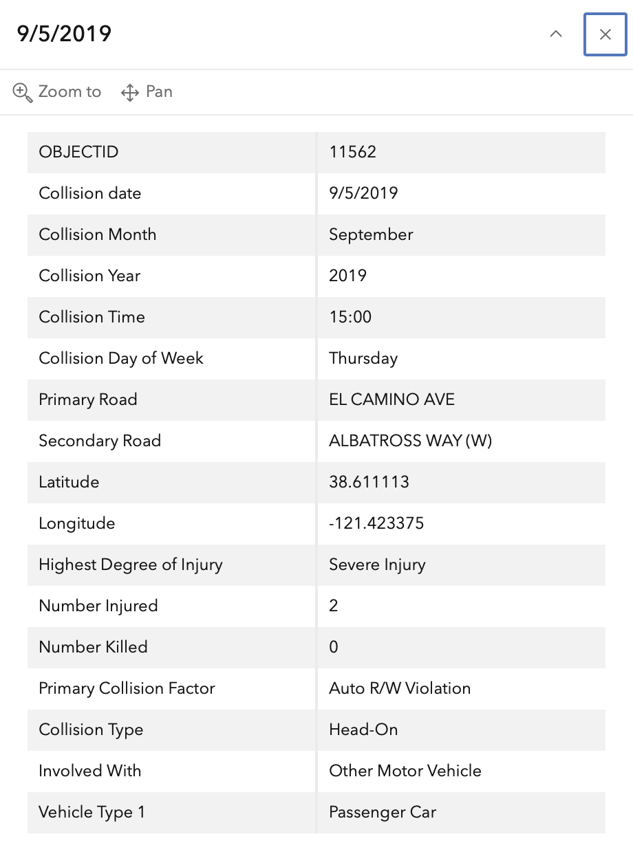
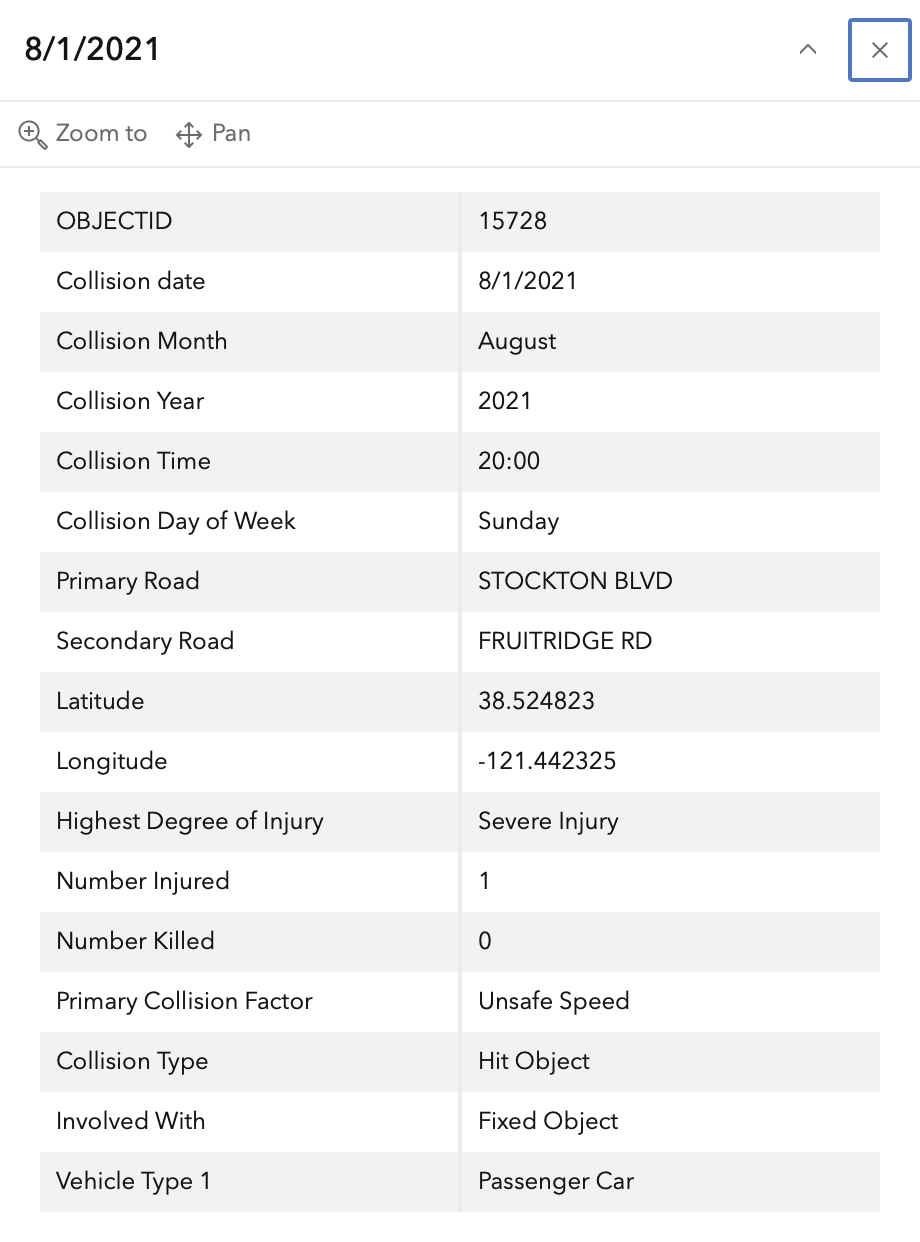
In the 2015 to 2024 period (which is used in the Vision Zero Action Plan Update), there were four severe injuries at this intersection, two with pedestrians and two with motor vehicles, mapped below (pdf). Please note that the exact crash locations may not be accurate, as police reports often do not correctly locate crashes. Also note that ‘pedestrian violation’ entry may be false, as police often blame crashes on the person walking when actual responsibility is not clear, or the pedestrian is dead and can’t counter the driver story.

The orange dots are severe injuries (one contains three crashes); there are no red dots (fatal). Together, these are know as KSI = killed or severe injury. ‘The other categories of crashes, ‘Other visible injury’ and ‘complaint of pain’ crashes are not shown on my map, since these are not the focus of Vision Zero, however, there are quite a number of these at this intersection, on both Stockton and Fruitridge, which you may view in the Crash Dashboard Interactive Map.

map of Fruitridge Rd & Stockton Blvd crashes
Fruitridge Rd & Stockton Blvd, VZAP update Top 20

The crash details, available in the Vision Zero Crash Dashboard Interactive Map, are below.
SacCity: VZ intersection 1: Elder Creek/47th & Stockton

Note: This is only one of 20 intersections. It is unlikely that I will be able to map and analyze all, but this post will provide an indication of the information available. General information on the Top 20 intersections, with criteria, list, and map, follows the information about this intersection.

I am looking more closely at the Top 20 intersections identified in the City of Sacramento Vision Zero Action Plan Update. The intersection at the top of the list is Elder Creek Road/47th Avenue and Stockton Blvd. This is mis-labeled in the document, as Elder Creek Rd and 47th Ave, but the east-west roadway changes names at Stockton Blvd, so the intersection is with both roads and Stockton Blvd.

Design

Lanes: Stockton Blvd at this intersection is 7 lanes wide (two northbound, two southbound left turn, two southbound through, and one southbound right turn). 47th Avenue is 6 lanes wide (two westbound, two eastbound through, and two eastbound left).

Elder Creek Road is 6 lanes wide (two eastbound, two westbound left turn, two westbound through), but also has a 6.5 foot wide ‘lane’ on the right that appears to be used as a right turn lane by some drivers. This indeterminate lane seems to be the locale of four of the five crashes at this intersection.

The intersection has two uncontrolled slip lanes, which are a known safety hazard, from Stockton Blvd southbound to 47th Avenue westbound, and Stockton Blvd northbound to Elder Creek Road eastbound. However, these were not the location of the crashes shown.The intersection has double left turn lanes on all legs, which are a known safety hazard. However, these were not the location of the crashes shown.

Total lane count is 26.

Medians: All four legs of the intersection have concrete medians.

Crosswalks: All four legs of the intersection have crosswalks, however, these are low-visibility parallel lines.

Bicycle Facilities: All roadways have Class 2 bike lanes, however, they have major gaps, are poorly marked, become advisory approaching the intersection. None have green paint or protection.

Speed: The posted speed limit on Stockton is 40 mph, on Elder Creek is 45 mph (!), and on 47th is 40 mph.

Transit: The intersection area is served by SacRT routes 51 Stockton Broadway and 68 Oak Park.

Crashes

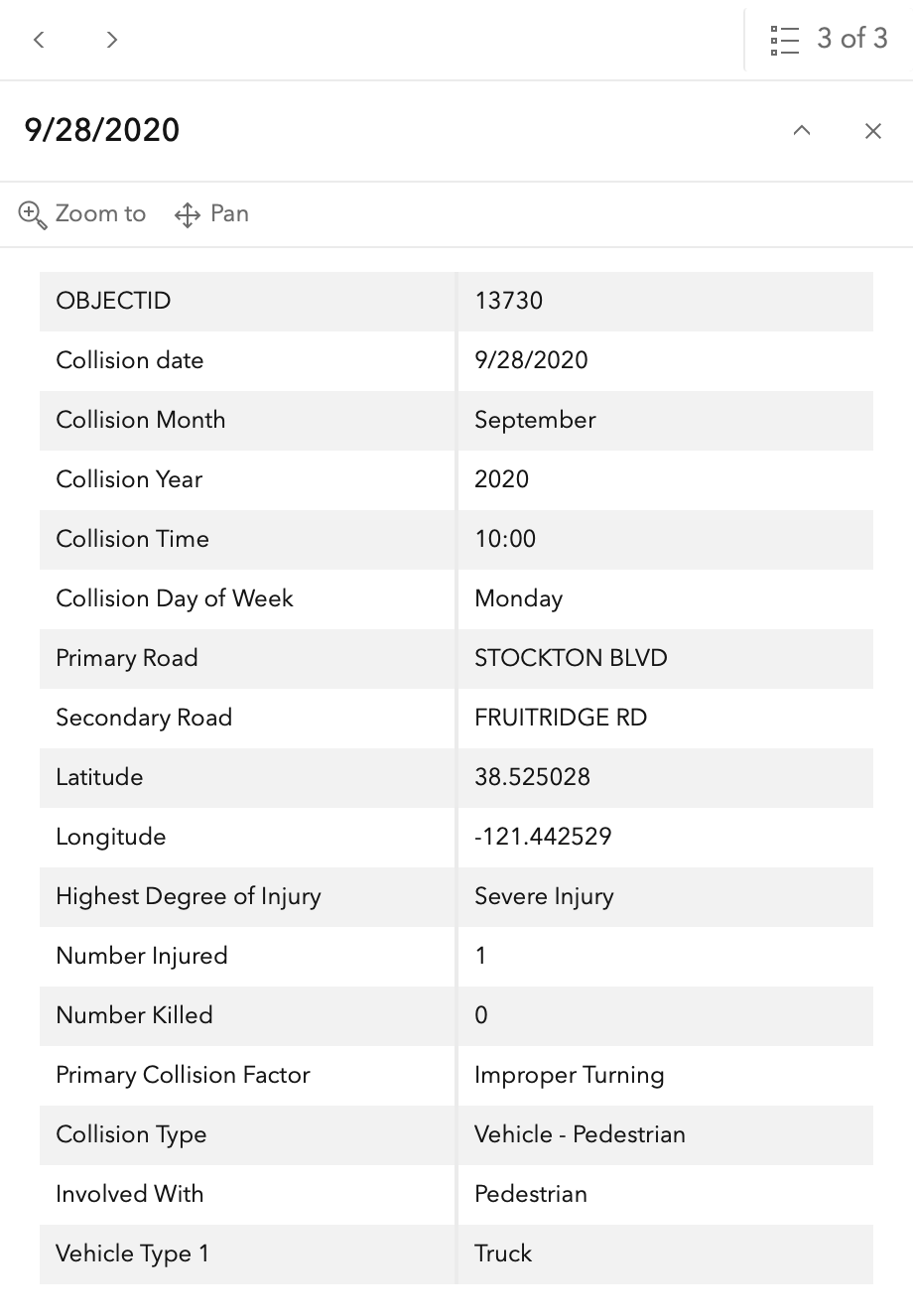
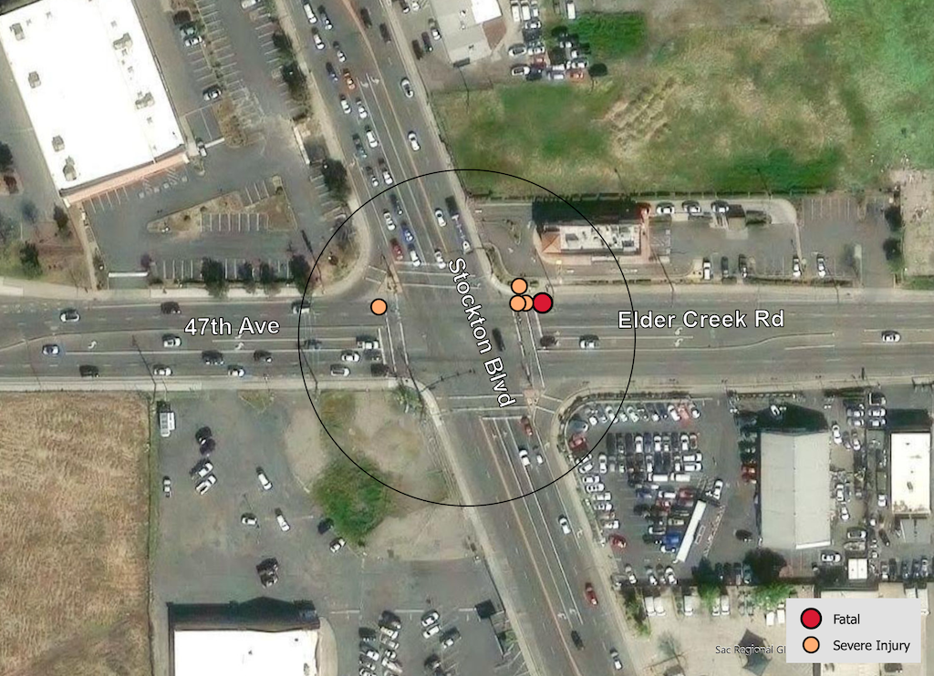
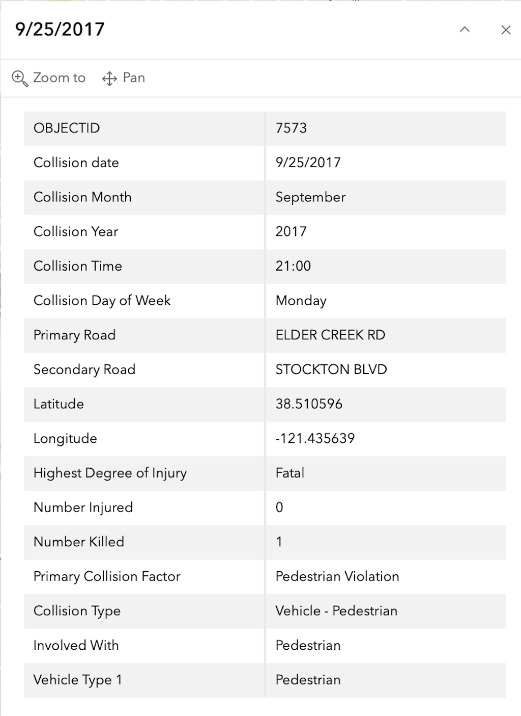
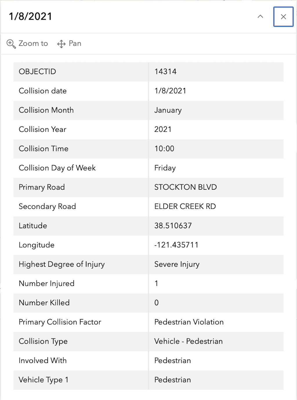
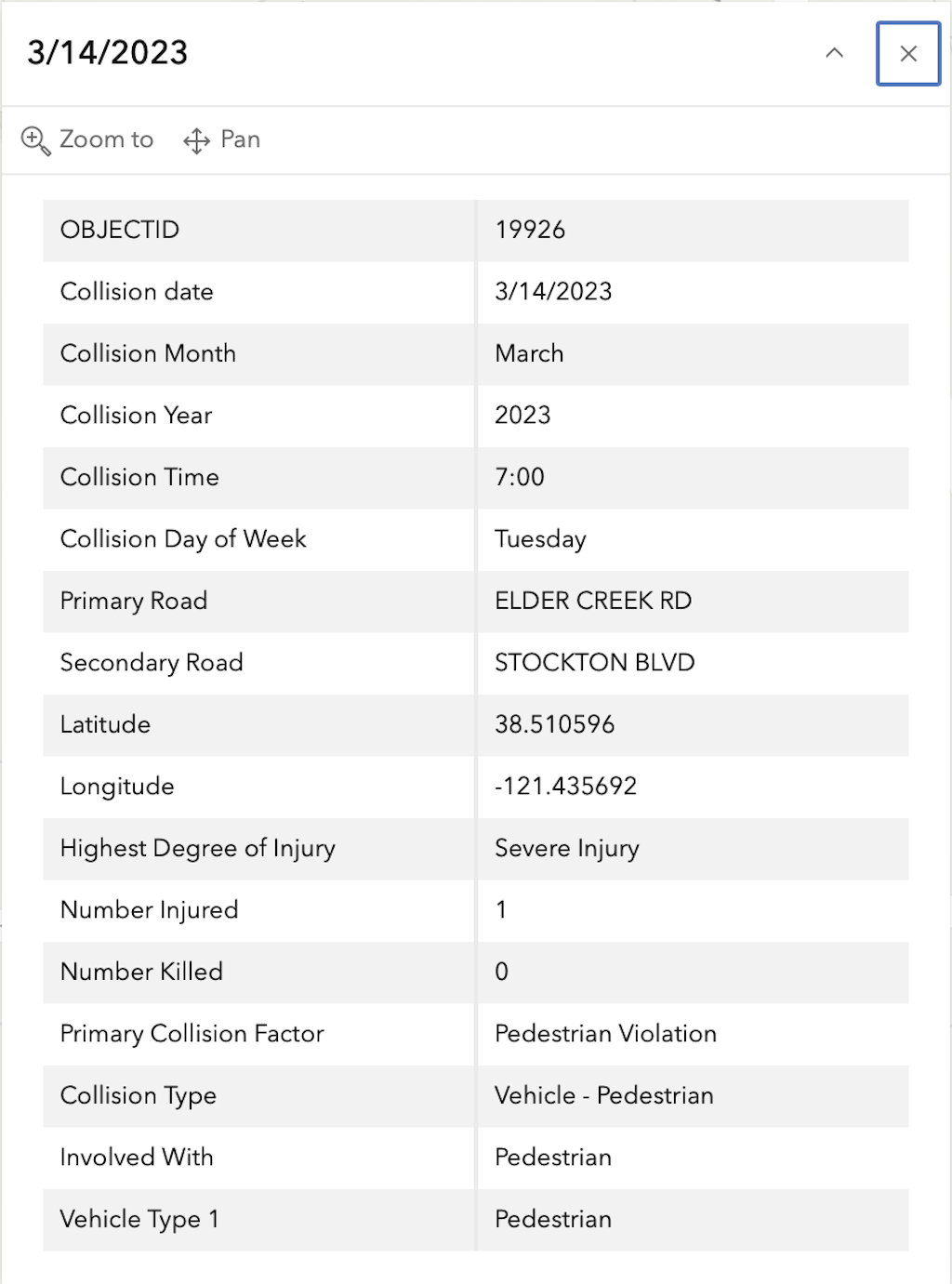
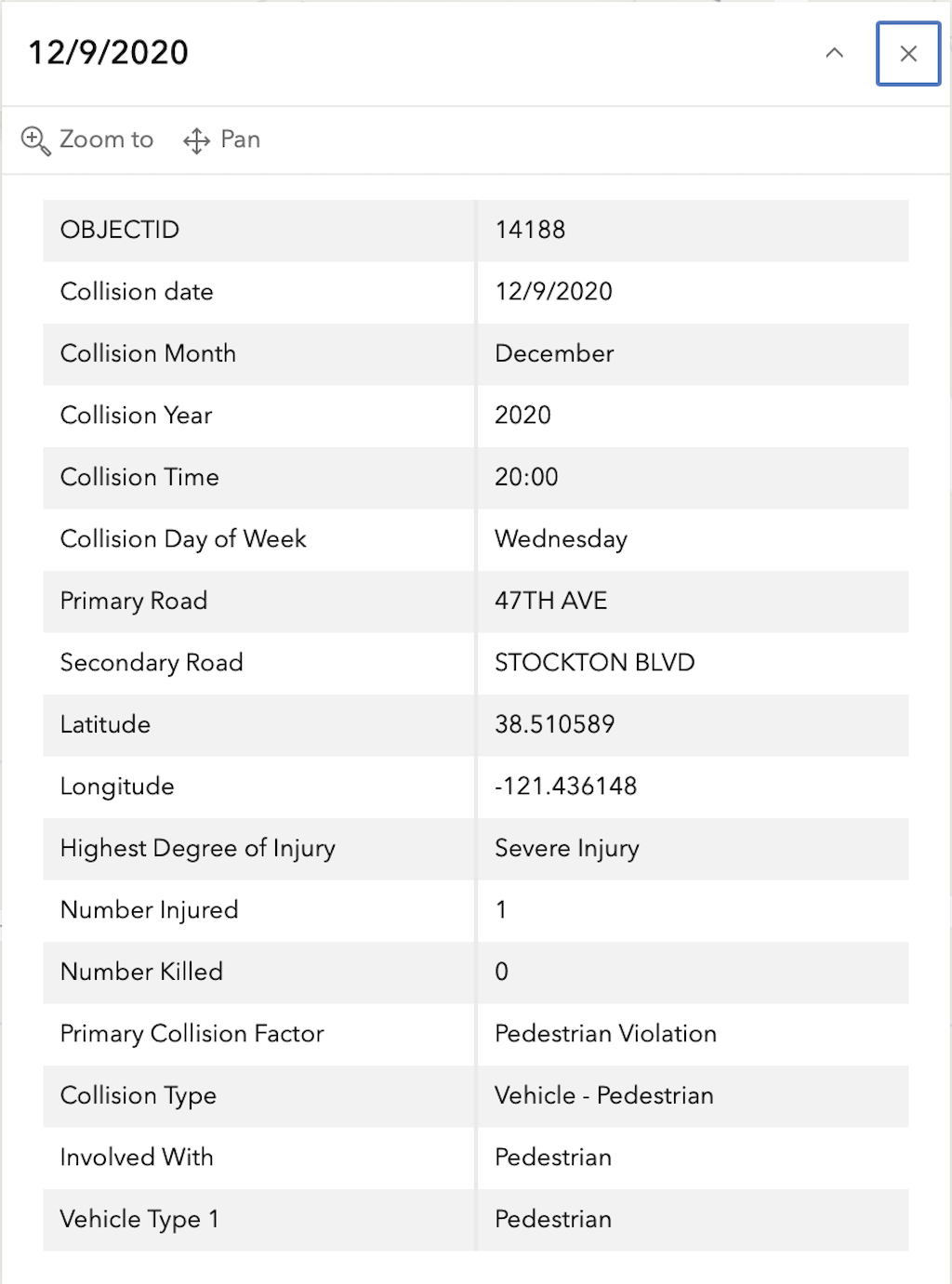
In the 2015 to 2024 period (which is used in the Vision Zero Action Plan Update), there was one fatality and four severe injuries at this intersection, all of pedestrians, mapped below (pdf). Please note that the exact crash locations may not be accurate, as police reports often do not correctly locate crashes. Also note that ‘pedestrian violation’ entry may be false, as police often blame crashes on the person walking when actual responsibility is not clear, or the pedestrian is dead and can’t counter the driver story.

The red dot is the fatal, and the orange dots (one is covered by another) are severe injuries. Together, these are know as KSI = killed or severe injury. The other categories of crashes, ‘other visible injury’ and ‘complaint of pain’ are not shown on my map, since these are not the focus of Vision Zero, however, there are quite a number of these at this intersection, concentrated on the crosswalk over Elder Creek Road on the east side of the intersection, which you may view in the Crash Dashboard Interactive Map.

map of Elder Creek Rd/47th Ave & Stockton Blvd crashes
SacCity Elder Creek Rd/47th Ave and Stockton intersection crashes

The crash details, available in the Vision Zero Crash Dashboard Interactive Map, are below.

General Information on Top 20 Intersections

The selection criteria for the Top 20 Intersections is: “These intersections scored within the top 0.5 percentile of all intersections on the updated High-Injury Network. They are sorted by KSI crashes within a 150 foot radius.”
It is not clear how this criteria was used. Though there is some information about how the the High Injury Network (HIN) was developed, there is none on the Top 20 intersections, nor are there scores that led to the ranking. For intersection 3 Truxel & Arena, and 7 San Juan Rd & Northgate Blvd, there aren’t any KSI crashes, so I don’t know how they ended up on the list.

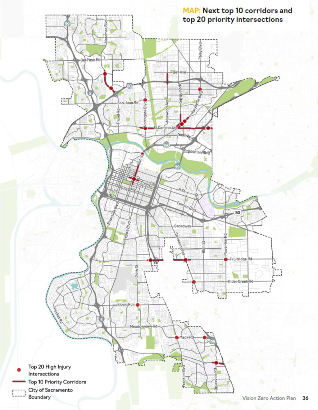
The list (pdf) of Top 10 corridors and Top 20 intersections is shown below, followed by the map (pdf) of these.

SacCity VZAP Top10/20 list
SacCity ZVAP Top 10/20 map