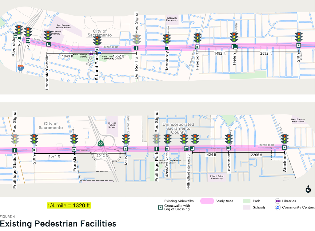
A map in the existing conditions report for Fruitridge Road Safety and Mobility Plan shows the location and nature of 20 crosswalks, including which legs of the intersection are present, or not. Of course these are the marked crosswalks. Under state law, there are crosswalks at every intersection, which is about 55 intersections. Of course on a high speed roadway, 35 mph or 40 mph posted and much higher actual speeds, it may not be safe to use legal but unmarked crosswalks.
It may be that the section between Martin Luther King Jr Blvd and 44th Street is over-signalized. Though I’m not against frequent safe crossings, a high density of signals just frustrates drivers and reduces the usefulness of the roadway for all modes. It is sort of like Trump passing out paper towels – you get one, you get one, you get one. Too many signals slow everyone.
I wasn’t happy with the detail of the map, and did not find in the existing conditions report distances between marked crossings. So I modified the map, below, to add distances for every segment over 1/4 mile, 1320 feet, and add street names. Two of the signals are pedestrian signals, not intersection signals, one for Fruitridge Park and Community Center, the other for the Del Rio Trail. These are greyed on the map.
Though obviously ignoring the existing street pattern would not make sense, the distances of more than 1/4 mile do deserve more analysis, since this exceeds the recommended distance for safe crossings on any collector or arterial roadway.
The crosswalks at Freeport are 101 and 111 feet long, with no refuge island and no pedestrian actuators on the medians. At Franklin, they are 106 feet and 125 feet, with no refuge islands or even usable medians. At Stockton, they are 82 feet and 100 feet, with no refuge islands or even usable medians. These are unacceptably long crossing distances, and must be shortened in the project. Reducing travel lanes from four to three, and eliminating dedicated right turn lanes and double left turn lanes will help with these crossing distances, but even when the roadway width is reallocated, it may be necessary to provide median refuge islands with pedestrian actuators.
 Getting Around Sacramento