Caltrans and Yolo County Transportation District are proposing to widen a section of Interstate 80 from Sacramento to the Yolo/Solano county line, a project called Yolo 80. This is not just a future project, subject to funding shortfalls and lawsuits, but is actually underway, as Caltrans illegally spends funds for highway maintenance on highway widening. I have written a number of posts on Yolo 80 and managed lanes, but today is just about the bike path that parallels Interstate 80 from the west edge of West Sacramento to Davis.
I am not a commuter or regular rider on the causeway path, but I do average riding it about once a week (I like concerts and beer and Mishka’s tea), and have been doing so for about 13 years.
For very rich people, who can afford to buy a new car every one or two years, a car is probably not an albatross. But for everyone else, who cannot buy a new car as often, or who can never buy a new car, they are an albatross.
A car loses about 20% of its value just being driving off the car lot, and about 15% per year thereafter. What other major investment do people make that loses value so rapidly? If you own a vehicle and claim it as a work vehicle, you can deduct this depreciation. For individuals, no such luck.
People focus on the cost of gas, pushing from their mind all the other ongoing expenses of registration, taxes, routine maintenance. But gas is only about half of the cost of keeping a car.
Cars always break down more frequently than expected, and always cost more to repair than expected. For lower income people, these unplanned breakdowns often push them over the edge.
The availability of cars and the roadways built specifically to support them (only in part paid for by gas taxes), encourages people to work and live further apart. But the CNT H+T Index says the real cost of decisions about housing and work are the sum of housing and transportation. The further away from everything one lives the less housing costs, but the more transportation costs. The ‘drive until you qualify’ expression focuses on housing costs and ignores transportation costs, but transportation is a significant portion.
Cars crash, whether it is the driver’s fault or someone else’s, the damage occurs. We’ve all seen crash damage that doesn’t get repaired because the cost of repair is more than insurance pays out, even if you have insurance, and many people don’t.
Cars fall apart. Stand on a corner and you will hear cars with loose wheel nuts rattling, loose exhausts rattling or making unwanted noise (not talking people who intentionally make their cars louder), hubcaps and trim and bumpers long gone. Older cars are belching exhaust, older cars are barely making it up hills, and many can’t even go on the freeway because they can’t keep up.
When cars are at the end of their life, they are a piece of junk for which there is no profitable recycling. If you want your car recycled, it is going to cost you money. Or you can let it sit in your front yard, or backyard, or garage, or the street in front of your house, as many do, rusting away and leaking toxic fluids. It is a liability to you and to society.
People who drive cars are routinely late because what they plan in their mind is a free-flowing trip, but that is not what usually happens. So they are late, and they drive too fast to try to make up for it. See ‘cars crash’ above. This is probably worst for school drop-off and pick-up.
Because cars allow people to travel longer distances to lower priced (and usually but not always lower quality) stores, locally owned businesses disappear, and we are left with chain stores and big box stores. One of the reasons restaurants and bars and coffee shops and entertainment are scarce in the suburbs is that many people drive to the central city, where such things are available. Good business for those of us who live in the central city, but bad for the suburbs. When was the last time you saw a quality locally-owned coffee shop in the suburbs?
When I view areas where the unhoused are living in their vehicles, I am amazed at some of the high-end vehicles I see there. Whether they are still running or permanently broken down, I don’t know. But every instance makes me wonder if buying a vehicle they could not afford, payments and maintenance, is what pushed them over the edge, into homelessness.
What have I forgotten? You people out there who own cars but wish you didn’t can add to the list in comments.
From the Measure A 2022 transportation sales tax measure, Implementation Guidelines, paragraph F: ““Fix It First” Investment Priority for Years 1-5. With the exception of Caltrans and the Capital Southeast Connector Joint Powers Authority, Authority allocations for the first five years following implementation of this Measure shall prioritize “Fix It First” road, transit, safety, bicycle, and pedestrian investments.”
For the first five years of the measure, if it passes, the county and cities will be obligated to prioritize (that word is not defined) fix-it-first, which most people think of as fix-my-potholed street. What about the other 35 years of the measure? The agencies can then go back to what they have been doing all along, which is de-prioritizing maintenance in favor of building new stuff. Potholes in your street? Broken sidewalks? Sorry, we are going to spend the bulk of your tax dollars on building new stuff.
A measure that really cared about the quality of our transportation network would prioritize a state of good repair, not just for five years, but always. Of course traffic engineers know that is not possible. We have already built more than we can possibly maintain. But rather than being honest about that, the county and cities have adopted a policy of full-speed-ahead with new stuff – more freeways, more interchanges, more pavement.
Note also that Caltrans projects and the Capital Southeast Connector are exempted from even that meek requirement.
The proposed transportation sales tax measure includes several paragraphs on fix-it-first. The concept is that our transportation network should be maintained in a state of good repair, and that existing infrastructure should be maintained before new stuff is built. It is clear that we are not there. In fact, we can never get there. We have built more infrastructure than we can possibly maintain. There is no amount of money or taxation that can maintain what we’ve built. That is true everywhere, not just Sacramento County.
Many people were disappointed that SB 1 increase in gas tax didn’t fix very many streets. The legislation was directed mostly to state highways, and only partly to local streets and roads. Even at the state highway level, it is not enough money. At the local level, the amount of funding is a tiny fraction of what would be needed.
The proposal acknowledges the need for maintenance, beginning with the second paragraph of the Local Street and Road Repair and Transformative System Improvements section. The sales tax proposal is in part an attempt to overcome the local maintenance deficit with local funds.
For the first five years following implementation of this Measure (April 1, 2023, to March 31, 2028), not less than 90% of the funds identified for the Local Street and Road Repair and Transformative System Improvements program shall be used exclusively by all cities and the County of Sacramento for “Fix It First” road and bridge preventative maintenance and rehabilitation, including safety improvements, so as to bring these facilities throughout Sacramento County to a pavement condition index (PCI) of at least 70 at the soonest possible time, and bridges to meet acceptable state and federal standards.
Exhibit A: Transportation Expenditure Plan
This commitment is good. Every survey has indicated that fix-it-first is the highest public priority, and this interest probably accounted for much of the yes votes for the 2016 Measure B.
At the end of the five-year period following the date of implementation of this Measure (after March 31, 2028), not less than 50% of the funds identified for the Local Street and Road Repair and Transformative System Improvements program shall be used exclusively by all cities and the County of Sacramento for “Fix It First” street, road, and bridge preventative maintenance and rehabilitation so as to continue efforts to bring these facilities throughout Sacramento County to PCI of at least 70, and bridges to meet acceptable state and federal standards.
Exhibit A: Transportation Expenditure Plan
So, for the next 35 years of the measure, the allocation to maintenance can be much lower, or zero if PCI 70 is achieved. This seems reasonable, in the sense that if every cent were spent on maintenance, nothing new would ever be built. Of course, when it comes to motor vehicles, that would be just fine with me. But probably not with the public.
Notwithstanding these allocation restrictions, the percentage commitments to “Fix It First” maintenance and rehabilitation may be reduced, and any city and the County of Sacramento may direct a higher percentage of those funds to new transformative system improvements, provided the following conditions have been met:
The public agency manager responsible for road maintenance has certified in writing to the City Council and City Manager in a city and the Board of Supervisors and the County Chief Administrative Officer that the road facilities under their management have met or will meet within the next 12 months a 70 PCI rating.
The public agency manager responsible for road maintenance has submitted a written plan to the City Manager or County Chief Administrative Officer clearly demonstrating how the 70 PCI rating will be sustained in the future. Any diversion of the funds committed to maintenance and rehabilitation can only continue as long as ajurisdiction maintains an average PCI of 70 or above for its street and road system.In addition, local jurisdictions must maintain current levels of funding for maintenance and rehabilitation and shall not use funds from this allocation to offset existing funding planned or allocated for this purpose.
Exhibit A: Transportation Expenditure Plan
What concerns me is that there are exceptions offered. The transportation agencies have gamed the system before, building new while not maintaining existing, and in fact that is the pattern of tranportation spending ever since World War II. It seems unlikely that they will immediately change their approach to infrastructure maintenance. What if it becomes obvious that our roads, bridges and other transportation infrastructure are continuing to deteriorate? Will the engineers and planners and politicians be willing to forgo the big new projects and ribbon cuttings?
Search for category Measure 2022 to see posts as they are added.
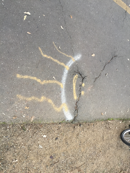
The photo above is a root heave on the American River Parkway path, west of Watt Avenue. This root heave started developing more than a year ago, and has of course gotten worse. Assuming that this will be a rainy winter, come spring the heaving will accelerate greatly.
The heave has been decorated by users at least twice, in an effort to alert other bicyclists to the hazard. But at night, the heave is invisible. The vertical displacement is about 2.5 inches, enough to make a bicyclist hitting it at speed lose control, or to throw them off their bike. It could result in serious injury or even death.
I have reported this issue to Sacramento Regional Parks via email, via phone calls, via Twitter, and directly to park rangers. Nothing has been done. More than a year, and it has only gotten worse.
This is just the worst heave, so far as I know, for the sections I ride. There are many more with less displacement. All have been marked by users in some way, indicating that users care much more about their safety than does Sacramento Regional Parks.
I will therefore suggest that Sac Regional Parks is incapable of maintaining this key part of the transportation network. Though they do from time to tine repave portions of the parkway, they have done nothing significant in the last three years. Measure A allocates $1 million of transportation funds per year to the parkway, but it has never been clear how these funds are being spent and many in the bicycle community question whether it is ending up ‘on the ground’ in path maintenance, or going elsewhere.
The responsibility for the parkway path needs to be transferred to the county department of transportation (SacDOT). It is not because they are a great agency, either, and anyone who drives or rides the streets in the county know how far behind the county is falling in maintaining their roads. The nevertheless, the parkway path is part of the transportation system, and needs to be considered as part of the system.
For a series on walkability, you might think sidewalks would come first, not later. The reason they are not first in the series is that sidewalks, relative to other issues, are in decent shape. Yes, vast areas are missing sidewalks, and in many areas that have them, they are not well maintained. But looking at the whole issue of walking, it is crossing roadways that is most dangerous and unpleasant, not walking along roadways.
I do not believe that low speed, low volume residential streets need sidewalks. It is OK that some have them, and it is OK to require them in new developments (to the degree that it is OK to have new developments, which is to say, this should be irrelevant because there should be no new developments). But to build sidewalks on quiet streets that do not have them is not the best use of funds.
The city has a lot of semi-rural areas without sidewalks. Do they not deserve sidewalks? Where sidewalks would provide a route to key amenities such as grocery stores and schools, sidewalks should be provided, or at least paved asphalt paths adjacent to roadways. Too many people die walking on the shoulders of rural and semi-rural roads, so shoulders are not a solution, there must be either sidewalks or separated paths.
The most important point of all about sidewalks is the first bullet, that it is the responsibility of the city to maintain sidewalks. It is irrational to propose that roadways are maintained by the city, but sidewalks are not. If this belief and legal fabrication persists, Sacramento can never be a walkable city.
Recognizing that sidewalks are an integral part of the transportation network, sidewalk repair will be the responsibility of the city and not of property owners, except where trees owned by property owners, or disturbance, change or widening is initiated by the property owner.
All streets with an ADT over 5000 will have continuous sidewalks of no less than four feet clear path, within five years.
All streets with an ADT over 10,000 will have a continuous sidewalk of not less than six feet clear width, within two years.
All streets with an ADT over 20,000 will have a continuous sidewalk of not less than six feet clear width, with a buffer of not less than six feet, within six years. Parallel multi-use paths can be used to meet this requirement.
Utility poles and other obstructions will not restrict sidewalk width below the minimums above, and where these exist, will either be removed or sidewalks widened. The expense will be borne by the utilities, not city taxpayers.
All sidewalks will be maintained in a state of good repair by the city. Any cracks with a vertical displacement of more than one inch will be fixed within two months. The city will evaluate and implement flexible sidewalks for locations with ongoing tree root heaving issues.
Timely leaf removal from sidewalks will be the responsibility of the property owner, except for sidewalks with a daily use of over 5000, which will be the responsibility of the city.
All development which requires new sidewalks (greenfield development) will fund a maintenance fund so that existing city residents are not financially responsible for sidewalk maintenance on new sidewalks.
Sidewalks will be continuous across alleyways, in concrete and not asphalt. Every alleyway that is reconstructed or repaved will have this implemented.
The Complete Streets movement, now 13 years old and with a newly released criteria for evaluating policies, is considered by some to be a success. Not by me.
There are two gaping flaws in the complete streets concept, that after all this time have not been addressed:
Who is responsible for sidewalks?
How close should safe crossings be?
Sidewalks: On the first issue, responsibility for sidewalks, most cities and counties (not all) have code that makes sidewalk maintenance the responsibility of the adjacent landowner. This includes repair and snow removal. Most cities have some money set aside to repair sidewalks, but only a tiny fraction of what is needed for the huge backlog of deteriorated sidewalks. A very few cities also clear sidewalks after snow. Sidewalks are every bit as much of the transportation network as travel lanes and bike facilities, but most places wash their hands of this reality and this responsibility, pushing it off to others. It has been pointed out that few cities and counties have the funds to also take care of sidewalks, but that is exactly the point. If we allow cities and counties to prioritize cars over walking, they will continue to do so.
How does complete streets play into this? It doesn’t. Complete Streets set no expectation that cities and counties will maintain their sidewalks. In the new policy rating documents, the word sidewalk only shows up twice, neither in this context. Even a search of the Complete Streets website only mentions sidewalks in relation to case studies and model projects. Fortunately, a few places do much better than just have a policy, but the Complete Streets movement does nothing to encourage this.
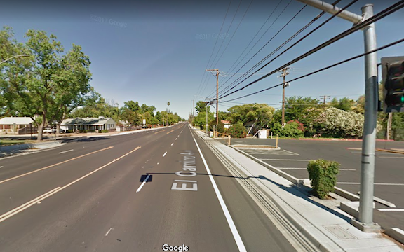
El Camino complete street, 0.3 miles to the next safe crossing
Crossings: the second great weakness of the complete streets movement and Complete Streets documents is the lack of attention to frequent safe crossings. The new criteria does not mention crosswalks or crossings. The illustrations of a complete street often show an intersection with high visibility crosswalks and sometimes curb extensions to increase visibility and shorten crossing distance. But other illustrations show long distances along a “complete” street, with the next safe crossing often not visible.
In the Sacramento region, every complete street project along arterials has added sidewalks and bike lanes, but none of them have added safe crossings. In fact, several of them have removed crossings. If a busy street is hard for walkers to cross, they won’t cross it. They will either drive, or just avoid the other side of the street. So that fancy complete streets project, with the wonderful looking wide sidewalks, does not serve the very people it is claimed to serve. People need to be able to cross any land all Streets in a safe crossing at an interval of no more than 1/8 mile. The grid in downtown Sacramento is 1/12 of a mile. Few places in the suburbs are less than 1/4 mile, and many are 1/2 mile. To me, this is unacceptable. I would think a complete streets policy would address this distance between safe crossings issue as being key to walkability. Again, the Complete Streets movement ignores this issue.
With the recent storm damage to roadways, as well as some transit and rail lines, the governor has proposed about $600M in quick fixes. This adds on to $59B deferred maintenance on state highways, and $78B on local roads (the actual local roads number is likely much, much higher). Pretty soon, we’re talking real money.
I am not opposed to fixing storm damage, or to keeping roads in a state of good repair, abbreviated SOGR and often called “fix-it-first.” However, if it isn’t obvious by now, let me clearly state that we already have more infrastructure than we can ever afford to maintain. Even without climate change, we probably could not keep up, and with climate change, we don’t have a chance.
We have a transportation system built on the idea that someday there will be enough money, our kids will be richer, the economy will be better, the federal government will offer an infrastructure windfall, a fairy godmother will wave her wand. It’s not going to happen. The bills are already coming due, and there will be far greater bills coming due in the near future. Politicians, and the voters who support them, have been running a growth ponzi scheme (see https://www.strongtowns.org/journal/2009/2/3/the-small-town-ponzi-scheme.html and other Strong Towns references), gathering the political and economic benefits today while putting the costs off to the future.
So, what to do? Well, first, stop digging the hole. We don’t need any new roads or highways, or additional lane miles. We do need to make the ones we have more efficient (defined as the number of people moved per hour per dollar, NOT the number of vehicles moved per hour per dollar), and on the whole, we do need to keep them repaired.
But we also need to realize that we have already overbuilt, and we are going to need to let go of some of it. Return rural roads and residential-only streets to gravel (bicyclists, get your mountain bikes). Stop paving parking lanes to the same high standards we use for the travel lanes, and in many cases, let them return to gravel as well. Or just remove some of them – we don’t need as many cars, either. Where sidewalks are needed and don’t exist, don’t take them out of people’s property, but out of the existing roadway. Where roads have been built wider than will ever be needed, take the extra width out and sell it off, with adjacent property owners getting first right of refusal. If there is no market, then give it away to the adjacent property owner. In suburban Sacramento county, there are streets that go from narrow two lane to four lane to extra-wide four lane and then back down again. These are safety hazards and maintenance nightmares. Let’s put this wasted road space back to productive use.
Freeways are the next big thing to reduce. The major Interstates are economically critical for freight movement and to a lesser degree people movement (though quality rail can take much of the pressure off). But they’ve gone from two lanes per direction to four to six to eight to ten, with Texas holding the record, I believe, at thirteen lanes per direction (in the U.S. at least). What are all the extra lanes for? Mostly commuters, and for about two hours a day. People who have been allowed and encouraged to live a long way from where they work, just to save on housing costs. But the bill has been paid by all of us, private car commuters or not, and we have only just begun to pay this bill. It may be larger than our entire economy. So, let’s shrink the Interstates back down, in most cases to two lanes per direction. The other freeways? Most of them are not needed at all and can be removed in favor of surface streets with a restored street grid. People will adjust over time, make different decisions, and it will take long enough to accomplish that it won’t be a sudden shock.
There is no better time than a crisis to re-think our transportation system. If we don’t think now, we will go back to sleep and assume that it is all going to work out, somehow, someday, some fairy godmother.
Each of these ideas deserves exploration, and I will do that as I can.
The City of Sacramento is working on a Transportation Development Impact Fee (TDIF) for the entire city, and with somewhat different requirements for subareas including downtown, river district, and North Natomas. The Sacramento Bee clued me into the proposal with Sacramento asks developers to open wallets to keep city streets from clogging (SacBee 2016-12-08). My initial guess was that this is in response to the failure of Measure B, but this proposal has been worked on since at least August, so that is not the case. The city has a webpage on development impact fees, with two documents specifically about the transportation DIF. I have not had the time to delve into the details, nor do I have any expertise in this area, so these are my initial thoughts.
The California legislature is meeting in special session to discuss sources of funding for transportation (they are on summer break, but will get back to it). The state uses the number $5.7B as the annual shortfall in funds available for maintenance, and these discussion are largely an effort to close that gap. Some of the solutions are: 1) indexing the gas tax so that it doesn’t fall behind (it was last raised in 1990); 2) increasing transportation related fees such as vehicle registration; 3) increasing the tax on specific fuels such as diesel; and 4) basing taxes on VMT (vehicle miles traveled) rather than fuel purchase. Of course there have been other ideas such as redirecting high-speed rail funds (which would be illegal unless legislation and the voter-passed bond are completely undone), and using cap-and-trade funds for highways (also illegal because maintenance and certainly construction would not reduce greenhouse gases), but those right-wing ideas won’t receive consideration by me.
I think it extremely important that all taxes and fees be at least partially based on the weight of the vehicle. The amount of damage caused to roadways and bridges is almost exactly proportional to the weight of the vehicle, and those that weigh more should pay more, at least for the maintenance portion of the transportation budget. If, for example, VMT were used instead of or in addition to fuel tax, one mile by a lightweight passenger vehicle is in no way proportional to one mile by a heavy truck. The tax should instead be a multiplier of VMT and weight, with a strong component of weight. And yes, all vehicles should be charged, including government-owned vehicles, which cause just as much damage to roadways as commercial vehicles. There has been a ballooning of vehicle sizes and weights with the government to match the commercial sector, and this is one way of bringing that under some control. Yes, I realize this means public buses would be paying weight fees, and I think this is appropriate since they do cause significant damage to the roadways. However, public transportation could be more than compensated as we save money on wasteful parts of our transportation system.
Vehicle registration fees are based on the type and price of a vehicle, which means that commercial vehicles are already paying relatively more than less expensive private vehicles, but they are not paying their fair share in relationship to damage caused to roads. It is not just an issue of commercial vehicles, however. Heavy passenger vehicles (you know what I’m talking about) also pay much less than their share of maintenance because the price differential is not as great as the weight differential.
Commercial vehicles do pay a weight fee, which is the sort of thing I’m requesting, but it is not assessed at a high enough level to pay for the damage caused, and at least for now these fees are being diverted to the general treasury rather than being used for maintenance.
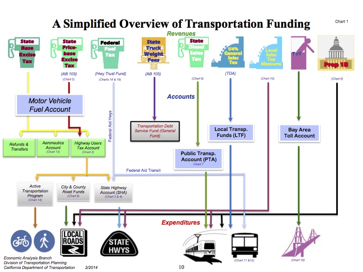
Note that I am intentionally ignoring the finer points of sales tax, excise tax, and the arcane fuel tax swap. They are important, but not important to this issue of all users paying their way. It is important to remember that only a portion of transportation funds in the state flows through the federal and state government. Local governments are actually the larger and more significant players. As well, the idea that gas tax pays for roadways is myth, it pays less than half, and has never paid all.
A lot of information about funding, including the chart above, is in the Transportation Funding in California – 2014 document from Caltrans. If this document doesn’t make your head spin, I don’t know what will.