SacCity: Arden-Auburn update

For previous posts, see Category: Arden-Auburn.

The draft plan for the Arden Way – Auburn Blvd Mobility Plan has finally been released. If you wish to comment on the draft, you will need to go through the project webpage, and answer questions, before receiving access to the document online. The list of documents down the page has not been updated, but a tile for the draft plan has been added near the top of the page.

The community workshop is this Wednesday, October 28, 5:30 PM to 7:00 PM, at 2200 Harvard Street, Sacramento.

I have briefly reviewed the draft, and have some initial comments.

The document refers to appendices, but they are not part of the viewable or downloadable document. I think that Appendix D may contain design information critical to understanding the project.

  • Appendix A. Existing Conditions Assessment
  • Appendix B. Community Feedback
  • Appendix C. Draft Concept Assessment Memorandum
  • Appendix D. Preferred Corridor Improvement Concepts
  • Appendix E. Opinion of Probable Construction Costs

The draft plans start on page 26 (6.1 Draft Plans).

The design and marking of ‘shared use path’ is not shown. Most of it is 10 feet wide, which needs some sort of marking for differentiation between bicyclist ‘lane’ and walker ‘lane’. The portion which is 12 feet wide may not require differentiation.

SR-160 ramps on the south side of Arden Way at the interchange will have signals added to protect walkers crossing the otherwise high-speed ramps. The ramps on the north side are identified for ‘mid-term improvements’, after uncertain negotiation with Caltrans. This is concerning.

Addition of sidewalk buffers (planting strips/landscaping) in several location is good, providing increased safety and comfort for walkers and bicyclists, but these should be on the entire corridor. The cross-sections for Harvard Way (page 35) and Auburn Blvd (page 36) show a sidewalk buffer of 7 feet. Eight feet is a minimum for healthy trees.

A cross-section of Arden Way (East Arden Way, page 27) shows double left-turn lanes. Double turn lanes are a known hazard that should not be retained or present in any safety project.

The intersections of Arden Way with Point West Way and Heritage Lane are shown as the highest crash rate intersection in the project, and Heritage Lane is the location of a KSI (Killed or Severely Injured) crash within the five year window. Yet no design is shown for these two intersections. It is likely that these are the most important locations on the entire project, and in fact should be the site of an immediate project to make them safer for everyone, and not deferred to this longer-term corridor project. This lack of attention makes me concerned that the planning effort to date has overlooked important safety issues.
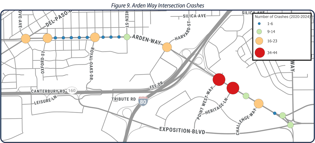
map of Arden Way Intersection Crashes

bike left turn Carlson Dr to H St

I was at a meeting last evening with transportation advocates when the subject of the turn left from Carlson Drive to H Street came up. Most people expressed discomfort about this turn, and most of the people were also experienced and skilled bicyclists. They felt that left turning motor vehicles, which go at the same time as left turning bicyclists, would encroach on the dashed green lane and hit bicyclists. They were also uncomfortable turning across the straight through lane, as they had seen people run this red light. This is a critical intersection and area for bicyclists, as it is one of four main routes onto and off the Sacramento State campus for bicyclists.

So today I went to take a look. I have not written about this intersection before, but two articles are of interest: SABA https://sacbike.org/carlson-corridor/ and City of Sacramento https://www.cityofsacramento.org/Public-Works/Engineering-Services/Projects/Completed-Projects/Carlson-Drive-Improvements.

So far as I know, this was the first use of green paint, and the first use of a bicycle signal head in the city. The installation was intended to be innovative, and it was, for its time, in Sacramento, but it hasn’t stood up to the test of time.

Here is what it looks like from above. As you can see, it is a complicated intersection with several features intended to ease and speed motor vehicles. The city attempted to make the intersection safer without really changing it at all, beyond the green paint. Green paint helps communicate, but it does not protect in any way, and it has no legal meaning under California Vehicle Code or city code.

Carlson Dr - H St intersection aerial
Carlson Dr – H St intersection aerial

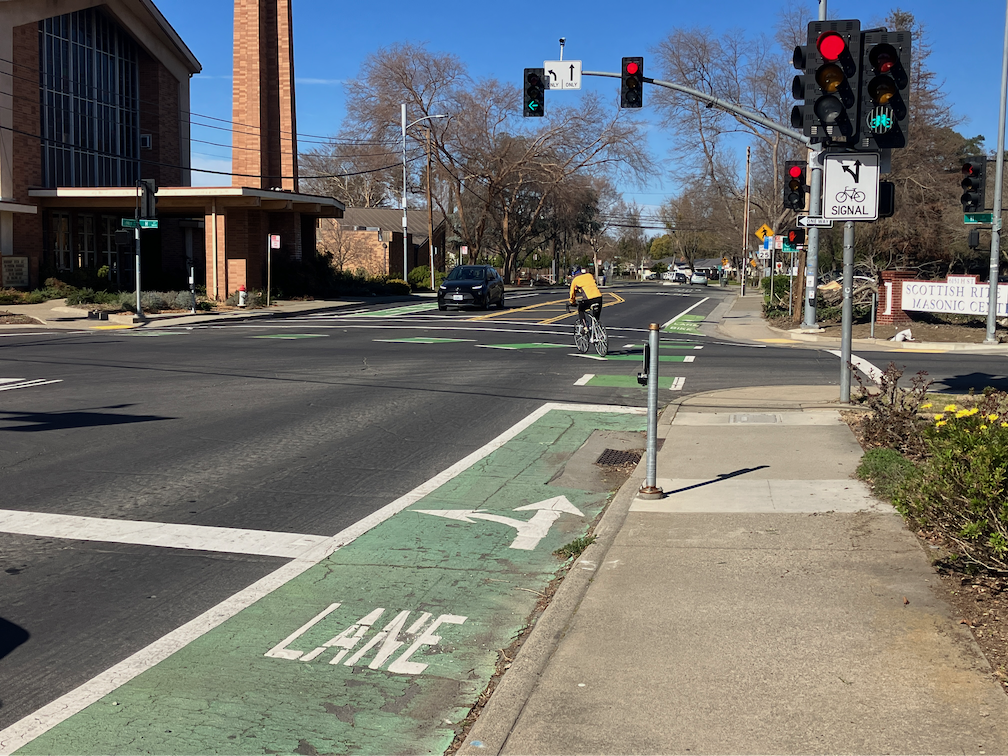
The two photos below show the setting of the left turn. The bicycle lane on the right side of the street leads to a dashed (skip) green lane turning through the intersection. The bike lane stop line is somewhat in front of the motor vehicle stop line, and there is a button to trigger the bicycle signal. The bicycle signal face is mounted to the right of the motor vehicle signal face, and there are two, before the intersection and on the far side.

bicyclist pressing the button to trigger the bicycle signal
bicyclist turning left from Carlson to H St; bicycle signal face green

I was there at a low traffic (motor vehicles and bicyclists) time of day and was unable to capture a bicyclist and motor vehicle adjacent to each other on the turn.

I have to say that I was not uncomfortable with the left hand turn. I’m a strong bicyclist and good at anticipating and mitigating for driver misbehavior. But I’m not the person bicycle facilities should be designed and built for. They need to be comfortable and legible (understandable) for any bicyclist, of any age and skill level, including Sac State students who seem to be the majority of the bicyclists here. This left turn is not.

There has been only one reported bicyclist injury crashes at this intersection since the green paint was put in (as of December 2020), and one in the 6-1/2 years before, so it is not a high injury intersection. But intersections like this discourage bicyclists, and so fewer people are willing to bicycle here. The poor quality of most of the access points to the Sac State campus probably in large part explains why the school has a much lower bicycling rate than most universities.

I don’t have a ready solution for fixing this intersection so that it is safe and comfortable (low stress) for bicyclists. But I do believe it is the city’s responsibility to study it, design a safe and welcoming intersection, and install it.

Freeport & Fruitridge intersection

Another post on the Freeport Blvd Transportation Plan. See the category Freeport Blvd for others.

The plan states, page Appendix A-9, “Fruitridge Road: The left turn from Freeport Boulevard to Fruitridge Road includes two left turn lanes, which may not be needed given the turn volumes. U-turns are moderately used at this location.” Despite this statement, the plan for this intersection is to leave it essentially unchanged. The diagram from Appendix F Design Layout is below.

Freeport - Fruitridge intersection design
Freeport Blvd Transportation Plan, Freeport-Fruitridge intersection design

The same seven lanes across for the north side of the intersection (to the right in the diagram), 86 feet for a person using the crosswalk, with no pedestrian refuge in the middle. Long crosswalks like this require a long pedestrian signal to meet federal standards, which of course slows all other movements in the intersection. In an effort to ease motor vehicle traffic by maintaining unneeded lanes, the city is actually slowing down everyone at the intersection, and making traffic worse rather than better.

The same dedicated double left turn lanes southbound (from the left). The same dedicated right turn lanes which require right turning traffic to conflict with the bike lane as they merge (out of the diagram left and right). The same free-right, high-speed slip lane from Fruitridge westbound to Freeport northbound which presents a tremendous hazard to walkers, bicyclists, and drivers traveling on Freeport.

Again, the city has released a final draft plan which fails to meet the needs of the community, fails to calm traffic, and fails to keep people (walking, bicycling, and driving) safe.