Note: General information on the Top 20 intersections, with criteria, list, and map, is available in post 1. Other posts on Top 20 intersections are available at Tag: Top 20 Intersections.
I am looking more closely at the Top 20 intersections identified in the City of Sacramento Vision Zero Action Plan Update. Intersection 15 is Grand Ave & Marysville Blvd.
Design
Lanes: Grand Avenue both west and east of Marysville Blvd is four lanes (one through, one left turn, one right turn, and one opposite). Marysville Blvd south of Grand Avenue is three lanes (one through, one left turn, and one opposite). Marysville Blvd north of Grand Avenue is five lanes (two through, one left turn, and two opposite). The corners on the north side of the intersection are a high radius, a known safety hazard. Lane total is 16.
Medians: Concrete medians are present on Marysville Blvd, but not on Grand Avenue.
Crosswalks: Crosswalks are present on all intersection legs, but it is unknown if they have been upgraded from the low-visibility parallel lines.
Bicycle Facilities: Marysville Blvd south of Grand Avenue has mostly separated bikeways, installed as part of the Marysville Vision Zero Safety Project. Marysville Blvd north of Grand Avenue does not have bike facilities. Grand Avenue west of Marysville Blvd has Class 2 bike lanes, though they become advisory at intersections, and do not have green paint or protection. Grand Avenue east of Marysville Blvd does not have bike facilities.
Speed: Grand Ave is posted 30 mph. Marysville Blvd is posted 35 mph.
The city no longer has a database or map of speed limits, though it has promised an updated database for many years now. I have used an old database, sometimes checked against Google Maps Street View for speed limit signs. The speed limits have not been field checked. The county (and SACOG) have a database, but it does not include the City of Sacramento roadways.
Transit: The intersection area is served by SacRT routes 15 Del Paso Heights and 86 Grand.
Crashes
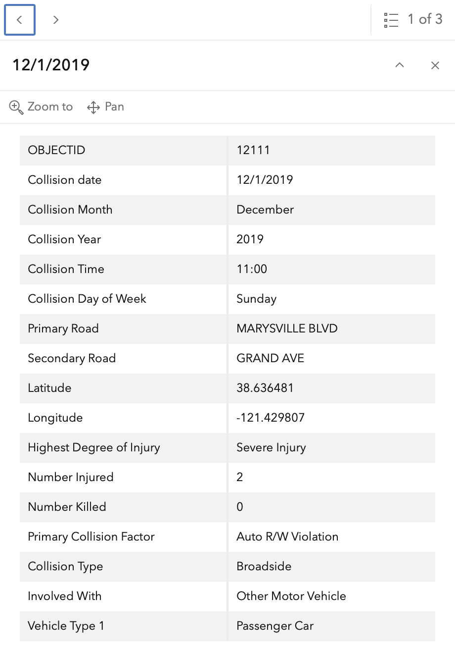
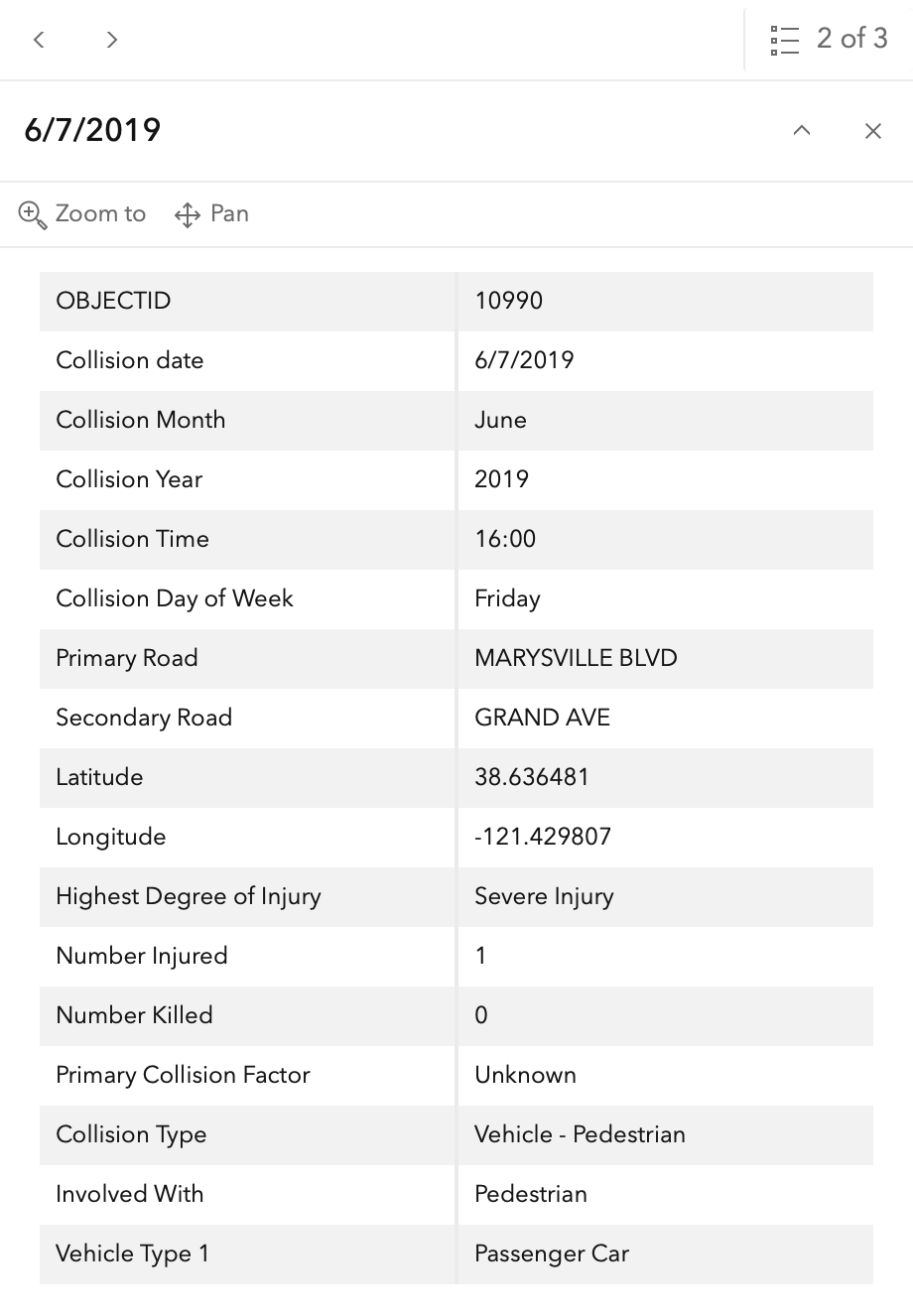
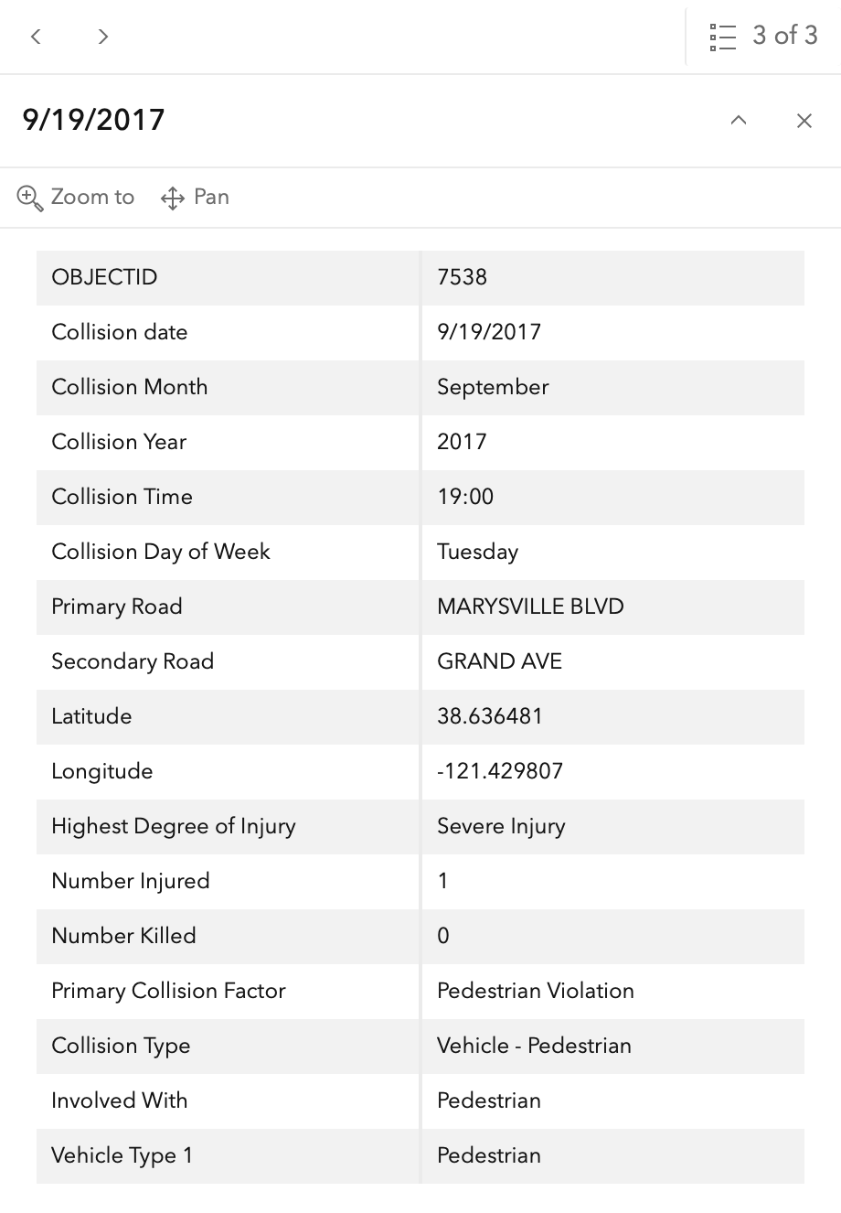
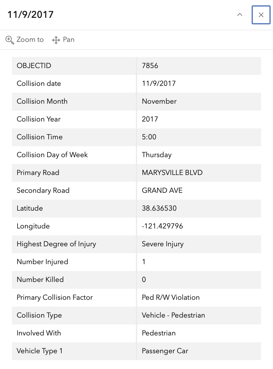
In the 2015 to 2024 period (which is used in the Vision Zero Action Plan Update), there were four severe injuries at this intersection, two involving pedestrians and two involving motor vehicles. These are mapped below (pdf).
The orange dots are severe injuries (one contains three crashes); the red dots are fatal (none). Together, these are know as KSI = killed or severe injury. ‘Other visible injury’ and ‘complaint of pain’ crashes are not shown on my map, since these are not the focus of Vision Zero, however, there are a few of these along both roadways, which you may view in the Crash Dashboard Interactive Map.
Please note that the exact crash locations may not be accurate, as police reports often do not correctly locate crashes. Also note that ‘pedestrian violation’ entry may be false, as police often blame crashes on the person walking when actual responsibility is not clear, or the pedestrian is dead and can’t counter the driver story.
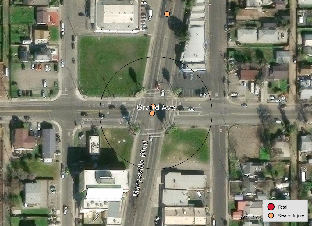
The crash details, available in the Vision Zero Crash Dashboard Interactive Map, are below.