removal of crosswalks

In today’s SacBee, an article on the City of Sacramento’s removal of crosswalks (Why Sacramento erased 23 crosswalks, including one where a grandmother died after removal), which has contributed to at least one fatality, had the following information from Ryan Moore, the City Traffic Engineer.

“To send the message via crosswalk that this is a good place to cross the road is a false message,” Moore said of the Oregon Drive intersection. “Our standards dictated that we remove the crosswalk or build safety enhancements.” The city would have kept the crosswalk marking in place, he said, if it would have been able to install a traffic light there. But the money – in the $500,00 plus range wasn’t available. Instead, traffic engineers hope that by removing some crosswalks, pedestrians will instinctively choose to cross at a safer, nearby intersection, Moore said.

This is definitely the engineer perspective that says lives don’t matter as long as policy was being followed, and the windshield perspective that it is OK to make pedestrians walk out of their way so long as drivers are not inconvenienced.

Freeport-Oregon.png
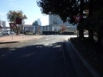
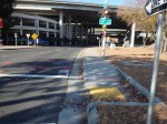
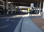
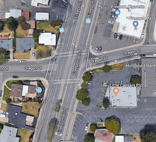
As you can see to the right, at the intersection of Freeport and Oregon, there are residences to the west and businesses to the right. There are signalized crosswalks about 700 feet to the north and about 700 feet to the south, but walking to either of these adds a one-quarter mile walk. Is this reasonable or not? It could be argued either way, but to discount it as Mr. Moore did demonstrates bias against pedestrians. The Google Map photo is from before the removal of the crosswalk.

The suggestion that nearby intersections are safer is also questionable. At the intersections of arterial roads, which Freeport and Fruitridge to the south are, drivers routinely fail to yield to pedestrians in the crosswalk on right turns. That is in fact why many walkers prefer to cross away from major intersections.

Common estimates of the expense of a HAWK signal (High-intensity Activated crossWalK) are $100,000, not $500,000. $500,000 is the cost of a fully signalized intersection. So Mr. Moore’s $500,000 number is a straw man meant to deflect criticism by saying the solution is more expensive than it really is.

There are solutions to this particular problem, and to the removal of crosswalks in general:

  1. The city should be required to perform a complete traffic study before removing any crosswalk. The city is always saying that they have to do traffic studies before anything can be done to change traffic flow, so I would presume that doing a traffic study in this situation would be a no-brainer.
  2. If the traffic study indicates that the crosswalk is unsafe, then the next step is to design a solution or options, with a funding estimate, and then go to city council with a request for the funding.
  3. The city council would have to hold a hearing, either as part of the regular city council meeting or as a separate meeting, to gather public input on the removal. If the city council then makes a decision not to expend the funds to create a safe crossing, the crosswalk can be removed.
  4. If a crosswalk is removed, the city would be required to post informational signing at that location with distances to the nearest safe crossing in both directions, so that pedestrians can make informed decisions. The signing would have to stay in place for at least two years.

Anything short of these actions makes the city engineers both morally and legally responsible for any fatalities or severe injuries that occur at the site of a removed crosswalk.


Complete Streets aren’t

The Complete Streets movement, now 13 years old and with a newly released criteria for evaluating policies, is considered by some to be a success. Not by me.

There are two gaping flaws in the complete streets concept, that after all this time have not been addressed:

  • Who is responsible for sidewalks?
  • How close should safe crossings be?

Sidewalks: On the first issue, responsibility for sidewalks, most cities and counties (not all) have code that makes sidewalk maintenance the responsibility of the adjacent landowner. This includes repair and snow removal. Most cities have some money set aside to repair sidewalks, but only a tiny fraction of what is needed for the huge backlog of deteriorated sidewalks. A very few cities also clear sidewalks after snow. Sidewalks are every bit as much of the transportation network as travel lanes and bike facilities, but most places wash their hands of this reality and this responsibility, pushing it off to others. It has been pointed out that few cities and counties have the funds to also take care of sidewalks, but that is exactly the point. If we allow cities and counties to prioritize cars over walking, they will continue to do so.

How does complete streets play into this? It doesn’t. Complete Streets set no expectation that cities and counties will maintain their sidewalks. In the new policy rating documents, the word sidewalk only shows up twice, neither in this context. Even a search of the Complete Streets website only mentions sidewalks in relation to case studies and model projects. Fortunately, a few places do much better than just have a policy, but the Complete Streets movement does nothing to encourage this.

ElCamino-eb
El Camino complete street, 0.3 miles to the next safe crossing

Crossings: the second great weakness of the complete streets movement and Complete Streets documents is the lack of attention to frequent safe crossings. The new criteria does not mention crosswalks or crossings. The illustrations of a complete street often show an intersection with high visibility crosswalks and sometimes curb extensions to increase visibility and shorten crossing distance. But other illustrations show long distances along a “complete” street, with the next safe crossing often not visible.

In the Sacramento region, every complete street project along arterials has added sidewalks and bike lanes, but none of them have added safe crossings. In fact, several of them have removed crossings. If a busy street is hard for walkers to cross, they won’t cross it. They will either drive, or just avoid the other side of the street. So that fancy complete streets project, with the wonderful looking wide sidewalks, does not serve the very people it is claimed to serve. People need to be able to cross any land all Streets in a safe crossing at an interval of no more than 1/8 mile. The grid in downtown Sacramento is 1/12 of a mile. Few places in the suburbs are less than 1/4 mile, and many are 1/2 mile. To me, this is unacceptable. I would think a complete streets policy would address this distance between safe crossings issue as being key to walkability. Again, the Complete Streets movement ignores this issue.

no-ped-crossing in the grid

no pedestrian crossing means three crossings

As mentioned in my recommendations for improving walkability in midtown/downtown, in response to the Sacramento Grid 2.0 program, I’ve developed more information including a map (at bottom) about the locations in the grid that are signed against pedestrian crossing. The signs at these locations may be the modern MUTCD R9-3a sign, shown at right, or the older text sign, shown below, or variety of non-standard signs. Update 2015-07-27: 37 locations.

5th-St-I-St_no-ped-crossingThere are a large number of other locations where crossing is discouraged by the lack of sidewalks, curb ramps, and crosswalks, but is not specifically prohibited.

As can be seen from the map below, the majority of the no pedestrian crossing locations are along the Capitol Expressway (Business 80) and US 50 freeways. These freeways, designed and constructed by Caltrans, are barriers to pedestrian use. In fact, they are a barrier to all use and livability because many of the grid streets do no continue under the freeways, making access more difficult for pedestrians, bicyclists, and motor vehicle drivers. In many cases there are no sidewalks on the freeway side of the adjacent surface street, so whether or not there is a safe or marked crossing doesn’t mean much without a sidewalk to connect to.

Read More »

crossing guard for DMV on 24th

crossing guard for DMV on 24th Street

The California Department of Motor Vehicles (DMV) has facilities on both side of 24th Street to the south of Broadway. Employees must go back and forth between the two facilities, but DMV does not think that it is safe for their employees to use the mid-block crosswalk without the extra protection of a crossing guard.

What are they being protected against? Well, drivers that have been licensed by DMV. Drivers who either do not know the law on yielding to pedestrians in crosswalks, or who choose not to follow it. Drivers who are distracted by cell phones. Drivers who drive over the speed limit. Drivers who are inattentive to their surroundings. You would think that maybe this hazard would cause DMV to reconsider their lackadaisical method of licensing motor vehicle drivers. Maybe drivers should be relicensed on a regular basis instead of receiving what is essentially a life-time license. Maybe drivers should have to demonstrate safe driving skills, knowledge of the law, and pro-social attitudes. Maybe. But DMV doesn’t seem interested in improving the safety of all roadways, but would rather solve a specific problem by using a crossing guard.

Another issue is that the street has been striped with a wide median in the center (not a physical median) to provide a place for the R1-6 Yield to Pedestrian signs and a refuge for pedestrians and the crossing guard. Normally this would be a good thing, but the wide painted median pushed the travel lanes to the side and pinches out the shoulder that is used by bicyclists. So in making things safer for pedestrians, the city has made things less safe for bicyclists. An appropriate trade-off if it were the only choice, but it is not the only choice. There is no logical reason for this section of 24th Street to be four lanes. To the north, it is two lanes, to the south it is two lanes. So the obvious solution is to road-diet the street so that it is two lanes or two lanes plus a center turn lane, if necessary and appropriate. The rest of the road width can be used for wide bicycle lanes.


I Street into Old Sacramento

The City of Sacramento sponsored Envision Sacramento website seeks input from the public on a number of issues. One of the topics was “What are your ideas on improving the Old Sacramento connection from downtown Sacramento via I Street?” You can view the comments, just below the survey, but to comment yourself you must create an account.

I Street entrance to Old Sacramento, from Envision Sacramento

The topic uses the photo at right to illustrate the question. What you can’t see in the photo is that behind the photographer and across 3rd Street (to the left), pedestrian access is on the south side, but to the west, it is on the north side.

Comments include a number about the aesthetics of this entrance to Old Sacramento, including the having a dark freeway under crossing as the main route into the one of the highlights of Sacramento, with poor signing for motor vehicle drivers, bicyclists, and pedestrians. A surprising (to me) number of comments, though, were about the transportation aspects, that it is really not safe for bicyclists or pedestrians to use this entrance, even if they know it is there, and the paucity of other options. I think it is clear that the commenters agreed that the way in which Interstate 5 severed the connections between downtown and Old Sacramento is a major issue.

A gallery of photos shows some of the specific problems at this location.

Read More »

Gallery: I Street into Old Sacramento

These photos are of the I Street entrance to Old Sacramento, showing various problems and hazards that exist for pedestrians and bicyclists at this location. The crosswalks here are not really safe. All sorts of signing has been installed to try to make them safe, but that is a poor substitute for correct design. The […]

Teaching children to cross

children crossing, Fauntleroy at Alaska, West Seattle (Seattle Bike Blog)

Streetsblog today posted an article “Our Streets Fail to Work for Children” which referred in turn to articles from Akron and Seattle. I commented on the Seattle Bike Blog post “We are failing our kids: A look at Seattle’s terrifyingly normal streets,” but I’d like to amplify my comments and specifically talk about pedestrian education.

Poor pedestrian infrastructure, as documented in these posts, is everywhere, more so in the suburbs and rural areas than in urban areas, but everywhere. The problems include:

Read More »

The I Street mess

Thank you, Elle, for reminding me in your “transportation ‘planning’ downtown” that I wanted to write about I Street. Note: If you are looking at Google Maps, it does not show the current lane configuration on I Street since the repaving and re-striping project of last fall, nor the realignment of tracks and work on extending 5th and 6th streets over the tracks.

I Street from the 4th Street crosswalk
I Street from the 4th Street crosswalk; I have the walk signal but this is still scary

I Street in Sacramento approaching the train station is a mess. Starting with the confusing floating bike lane between 7th and 6th streets (subject of a future post), the street becomes worse and worse: five lanes wide, high speed, and completely unfriendly to bicyclists and pedestrians. For pedestrians, the crossing on the east side of the I/5th intersection is uncomfortable because westbound traffic is already moving at high speed and often runs the red light, and right turning cars from I to 5th often do not yield to pedestrians in the crosswalk. The west side is so unsafe due to traffic turning left off 5th Street, it is signed against pedestrian crossing, even though this is a logical walking route from downtown to the train station. A crosswalk has been added on the east side of the I/4th intersection, but it has the same challenges that drivers are moving too fast and often run the run light. When I used this new crosswalk, I was very concerned, and I have a much higher tolerance for danger than most people do.

The right-most two travel lanes lead to the high-speed northbound I-5 freeway onramp, so drivers passing 6th Street are already accelerating to freeway speeds, many times going 55 mph as they cross through the I/5th intersection. The next two lanes lead to a medium speed onramp to the I Street bridge over the Sacramento river, and to the southbound I-5 onramp. For pedestrians, the only way to go westbound towards Old Sacramento is to go through the parking lot for the train station and under the onramps along an ugly, dark, poorly marked pedestrian way.

Read More »