SacCity street design standards

I had recently posted on the design for alley sidewalk crossings, based on a document from the City of Sacramento website. I shortly thereafter discovered that there are at least two sets of standards. The Department of Utilities, on the Development Standards page, has a Standard Specifications document which includes some text about streets, and the Transportation appendix of standard drawings which contains the diagram referenced. If you look at the text document, you will notice that it does not link itself to the Department of Utilities. Who wrote it, who would you contact about it? Who knows. Why the Department of Utilities has its own designs, separate from Department of Public Works, which has assigned responsibility for transportation, isn’t clear at all. On the positive side, though, this document was updated November 2020.

The Department of Public Works has its own Section 15 – Street Design Standards, part of the Design and Procedures Manual, linked on the Public Works Publications page. This is the document I discovered after using the Department of Utilities document. On the negative side, this document was last updated in June of 2009. Fourteen years ago. Again, there is no attribution to department in the body of the document. I only know/think this is a Public Works document because it is linked from a PW page.

There have been immense changes in street design best practices in that time. Most of the diagrams are overviews of arterial and collector roadways, very little about other streets. Bike lanes of any sort? Nada. ADA ramp details? Nada. Protected intersections? Nada. Curb extensions (bulb-outs)? Nada. Traffic calming infrastructure? Nada. The text of the document does contain references to a few of these issues, but without corresponding diagrams, there really is no guidance at all.

In searching for design diagrams, it appears there are additional designs scattered across the city website, some of them having to do with subdivisions, which seem to be treated separately from other street design. Let me say that this is not at all clear. The city website contains many documents without attribution to the department which created it. The city search engine is one of the poorest I’ve ever seen, and when it finds a document, it is almost impossible to tell where it came from or on which webpage one might find it.

At the SacATC (City of Sacramento Active Transportation Commission) meeting on 2023-03-16, staff presented an Introduction to Current Active Transportation Efforts. Under Projects, item 6 is ‘Street Design Standards Update: website expected in Fall 2023’. I spoke at the meeting about the weakness and antiquity of the current standards, and about the confusion over which set of standards is being talked about. City code, in Title 17 Planning and Development Code also has references to street design, but no linkage to the corresponding street design documents or diagrams. I don’t think staff realized how big a mess this is. It is not just the Public Works document that needs to be updated, but all city references to street design pulled together and properly referenced and linked.

A post in the near future will provide my ideas about what a street design manual ought to look like.

cover page of Section 15 - Street Design Standards, of the Public Works Design and Procedures Manual

sidewalks across alleys

Note: Please see post on City of Sacramento Street Design Standards. It turns out that there are at least two different sets of design standards.

The City of Sacramento has Standard Specifications and Drawings that require certain designs for the public right-of-way. There were last revised April 2020, and are available on the Utilities: Development Standards page. It is not clear why these are part of Utilities rather than Public Works or Community Development, but they are. Though I haven’t done an element by element comparison, they seem to be a considerable improvement over the previous standards, which seem to be June 2009.

There are designs which are not being followed, and others that should be eliminated. Today, I’ll address sidewalks crossing alleys. Alleys are only common in the central city, but they do exist other places throughout the city.

The city design standard is below (pdf of entire page). The detail is hard to see, but the alleyway, sidewalk, and alley driveway are all concrete, none are asphalt. The T-11 Standard Alley Entrance Detail page says “Portland Cement Concrete (PCC) is the city standard pavement for alleys.”

SacCity Specification detail alley entrance

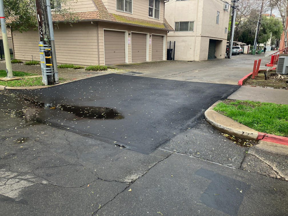
Of course there are many alleyways that are asphalt, and some that are unpaved gravel. I don’t know when the city standards changed to require pavement, or when to require concrete, but those are the current standards. That means that if an alley, or a sidewalk, or the alley driveway is changed, it must meet current standards. Below is a photo of Neighbors Alley at 17th Street, which was just redone within the last two months. It clearly does not meet city standards. Both the driveway and the sidewalk are asphalt, not concrete. Though I noticed this work being done, I failed to notice who was doing it. City? Private? Private utility? Not sure.

photo of Neighbors Alley at 17th Street
Neighbors Alley at 17th Street
Read More »

SacCity red light cameras and crashes

A follow on to red-light-running bullies. I’ve created a map that shows the eleven right light camera (automated enforcement) locations under the City of Sacramento’s Red Light Running Program. The city has 907 signalized intersections. These locations are (listed alphabetically by the intersection entry in the Traffic Signals GIS layer):

  • 16th Street & W Street X
  • 21st Street  & Broadway X
  • 5th Street & I Street X
  • Alhambra Boulevard & J Street
  • Arden Way & Challenge Way X
  • Arden & Exposition Boulevard & Ethan Way X
  • El Camino Avenue & Evergreen Street X
  • Fair Oaks Boulevard & Howe Avenue X
  • Folsom Boulevard & Howe Avenue/Power Inn Road X
  • Mack Road & Center Parkway X
  • Mack Road & La Mancha Way/Valley Hi Drive X

The map (pdf) shows each location, with the red signal icon, and a heat map of the crash severity for crashes occurring at intersections. Yellow means high collision severity, with severity being a weighting of the individual types [1 – Fatal; 2 – Injury (Severe); 3 – Injury (Other Visible); 4 – Injury (Complaint of Pain)]. But it does show the pattern, and you can clearly see the intersections along arterial roadways, where most crashes occur. The crashes are not necessarily red light running crashes. There is a PCF Violation category (VIOLCAT) 12 – Traffic Signals and Signs, and another Intersection (INTERSECT_), but that would not distinguish red light running from stop sign running. It might take looking at individual incident reports, but that is beyond my capacity.

There are certainly high crash severity locations in the city that are beyond the map coverage area, and there are plenty of locations without cameras.

It would be interesting to know if these red light camera locations have a lower rate of red light running crashes that comparable intersections without cameras, but that will require quite a bit more thinking an analysis.

Read More »

SacCity should remove crossing at alleys prohibition

City of Sacramento code prohibits pedestrians from crossing streets at alleys.

10.20.030 Crossing at alleys.
     No pedestrian shall cross a through street at an intersection with an alley except within a marked crosswalk. (Prior code § 25.03.052)

https://library.qcode.us/lib/sacramento_ca/pub/city_code/item/title_10-chapter_10_20-10_20_030

While this code has always been an attempt to prioritize motor vehicle drivers over people walking, it is becoming increasing problematic as housing and businesses are now located along alleyways in the central city. ADUs and lot split housing are often accessed through alleys and not from the street. This code makes it so that anyone living or doing business in an alley must go out of the way to cross the street, and it prohibits people who just want to walk alleys to avoid busy streets.

The code should be excised.

does Sacramento enforce illegal parking?

As a person who walks a lot in the central city, and some in other areas, I often see and report illegal parking to the city through the 311 app. I’m not talking about parking too long, or not paying, but about blocking driveways, sidewalks, and crosswalks. 90% of the time, the response that I get was that a parking officer was dispatched and the vehicle was no longer there, so no citation was issued. I provide the license number, vehicle description, and a photo, but the city will not use that information to ticket once a vehicle has moved. But, the real issue it that they often ignore the violation completely.

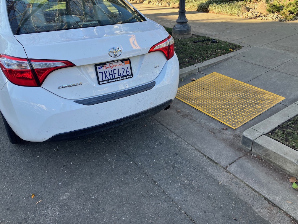
An example. I reported this illegally parked vehicle at 9:17AM. It was blocking the crosswalk over 13th St, and the ADA ramp. The remaining ramp area was not wide enough to allow a wheelchair to pass. At 11:09AM I received an email reply from the city, stating: “A Parking Enforcement Officer arrived at P ST & 13TH ST, SACRAMENTO, 95814 to find that the vehicle(s) reported were no longer on the scene.” At 7:30PM, the vehicle was still in exactly the same place. The officer was lying. The vehicle was still there. Either the officer never visited the location, or decided not to cite the vehicle.

illegally parking vehicle blocking crosswalk and ADA ramp
illegally parked vehicle, 13th St, not cited

This is the sort of attitude the city has toward people who walk, or roll. They are always less important than people who drive.

Freeport Blvd Transportation Plan

The City of Sacramento has released the final draft Freeport Blvd Transportation Plan. Appendix F Design Layouts is a key part of the document. This post reflects my original comments (Freeport Boulevard Emerging Design Concepts) and the new plan. The city’s plan page is at http://www.cityofsacramento.org/Public-Works/Transportation/Planning-Projects/Freeport-Blvd-Corridor. The plan is on the Active Transportation Commission agenda for January 20, 2023, and will go to the city council within the next two months.

The ten common design elements on page 21 (24 of the pdf) include: “10. Maintained necessary travel lanes, turn lanes, and parking: Maintaining travel lanes and turn lanes ensures that drivers traveling along the corridor will not be compromised, and preserving parking spaces where 5 the utilization is higher so it serves better adjoining businesses.” This is statement is contrary to all walkability, bikeability and vision zero goals. It should be removed from the document, and removed from planning goals. It is offensive. It means that no matter what other improvements to the corridor will be made, cars and motor vehicle drivers will be preferenced over all others.

The ten common design elements do not mention trees. Trees are an integral part of the walking experience, as well as providing climate and heat island benefits. They should be prominently recognized throughout the document, but they are not. The phrase ‘existing trees’ occurs many time in the document, but nowhere are ‘proposed trees’ identified.

Frequent driveways along much of this section present hazards to walkers and bicyclists, and handicap the design of safe streets. It is clear that the city did not consider reduction or narrowing of driveways to address this hazard. If you look at the design layouts (Appendix F), the number of gaps in the bikeway, shown as dashed green, is remarkable. Each of these is a driveway. Again, this is a clear indication that the city intended to maintain the car-dominated character of this street.

All crosswalks at intersections should contain all three or four legs (three for T-intersections). The design leaves many intersections with only one crosswalk over Freeport Blvd, meaning pedestrians must cross three streets in order to reach some destinations, rather than just one. Though not mentioned in the plan, this often means installing pedestrian crossing prohibition signs and barriers. These should be outlawed, not encouraged.

North Section

pages 25-26 (28-29 in the pdf)

The intersection of Sutterville Road to the east with Freeport Blvd is shown with a two-lane roundabout. Two lane roundabouts have almost none of the traffic calming and safety benefits of one lane roundabouts, in fact they should not even be called roundabouts, with the implication that they have safety benefits. This roundabout should be redesigned to a single-lane. Traffic levels on Freeport to the north certainly do not justify two lanes, in fact Freeport become single lane each direction a short distance to the north at 13th Avenue.

The dedicated right turn lane on Freeport Blvd southbound at Sutterville Road to the west is not needed and presents an unnecessary hazard to bicyclists. Dedicated right turn lanes should be eliminated from this plan, and from all city roadways. They are rarely justified by traffic volume, create conflicts for bicyclists, and widen roadways and therefore crossing distances for walkers. They also encourage drivers to make right hand turns without looking for people walking.

There should be a crosswalk on the north side of the Freeport-Sutterville intersection. There is no justification for leaving it out, unless an attempt to discourage walkers from accessing the park.

South Section

pages 27-31 (30-34 in the pdf)

The offset crosswalks with median refuge at Oregon Drive and Potrero Way/Virginia Way are a good design, but there is no reason to not provide crosswalks on the other leg of the intersection.

The median gap at Arica Way, with dedicated left turn lanes, is not needed. Arica Way is a low volume street that is a good candidate for right in/right out treatment. The shopping center access can be provided for northbound traffic.

At the intersection of Fruitridge Blvd and Freeport, there should be no dedicated right turn lanes. They create a hazard for bicyclists, that cannot be mitigated by pavement marking, and they lengthen the crossing distance for walkers. In this location, where center refuge medians are not proposed, this is particularly egregious. The dual left turn lanes southbound on Freeport are a hazard to bicyclists and motor vehicles, and should be reduced to a single left turn lane. This intersection, due to long crossing distances, should provide center refuge medians on both the north and south crosswalks.

why are bike lane gaps so important?

My last three posts have been about locations where sharrows replace bike lanes for one-block sections in the Sacramento central city: Sacramento’s worst possible place for sharrows; Sac kill those sharrows on I St; Sac kill those sharrows on H St. There may well be other such locations that did not come to mind. If so, please let me know so I can document and post on them. I’m not asking about locations that should have bike lanes, or where bike lanes should be upgraded to separated (protected) bikeways. There are simply too many of those locations for me to deal with.

So, why are bike lane gaps so important? Bike lanes are basically a promise to bicyclists that the city is providing a safe place to ride your bike. Yes, I know traditional bike lanes have serious safety issues (they are called door zone bike lanes, or DZBLs), but for the average rider, they are safer than no bike lane. But this promise is broken when there is a gap. For these gap sections, bicyclists who felt comfortable riding in a bike lane are suddenly left to deal with motor vehicle traffic in a location where neither the bicyclist nor drivers are sure how to behave. What does the average bicyclist then do? Decide never to ride on that street again. And if they have a scary experience, they may even decide not to ride again at all.

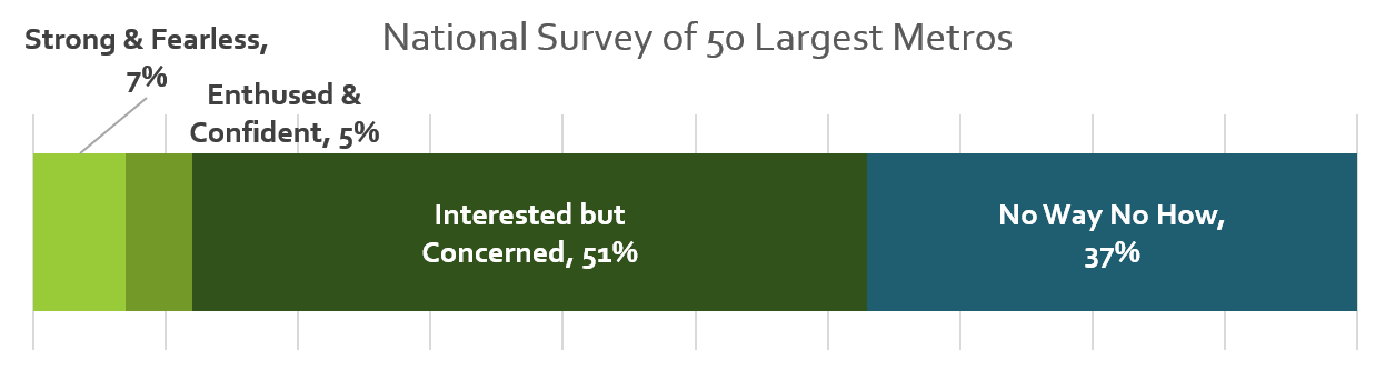
I’m a bicyclist with strong vehicular bicycling skills. I know where the safest place to ride is on every street, and I ride there no matter what motor vehicle drivers or law enforcement happens to think about it. But I am far, far from a typical Sacramento bicyclist. I am ‘strong and fearless’, though as I get older, I’m tending towards ‘enthused and confident’. The four types of bicyclists, or levels of comfort, developed in Portland but applicable to Sacramento, are shown in the graphic:

four types of bicyclists and levels of comfort diagram

The city should be designing bicycle facilities that work for all three categories of people who will bicycle. When there is a gap in a bike lane, the city has designed bicycle facilities that serve the ‘strong and fearless’, only 7% of potential bike riders. This is discriminatory. It is wrong. I suspect that with the resurgence of bicycling and the availability of e-bikes, the ‘no way, no how’ category has shrunk a bit.

The city must close bike lane gaps. Not off in the future when the street is repaved, or when a grant is obtained, but NOW. To do otherwise is to intentionally discourage bicycling and to risk people’s lives.

Sac kill those sharrows on I St

Next sharrows location to address is I Street between 10th Street and 9th Street. The bike lane present to the east disappears in this block, with Cesar Chavez Plaza on the south and Old City Hall on the north, before picking up again west of 9th Street. Not having my tape measure out (and I’d have to measure late night when there is no traffic), it isn’t clear why this one block does not have a bike lane. It may be that the curb extension is too wide, or it may be that the general purpose (car) lanes are not configured correctly. If lanes, then it is an easy problem to fix, just re-stripe the lanes and add a bike lane. If the curb extension, then that would require a bit of infrastructure work. I fully support curb extensions, nearly all intersections should have them, but in some places the city has installed them incorrectly and caused issues for bicycle facilities. This is not, as many places are, a case for removing parking, but for designing the street correctly. Of course ultimately there should be no three-lane one-way traffic sewers in the city, and right of way should be reallocated to a separated (protected) bikeway and wider sidewalks.

I St westbound at 10th St, sharrows, Sacramento
I St westbound at 10th St, Sacramento

Caveat: I post about issues in the central city because I live here, and see the problems every time I am out walking or bicycling. However, I strongly believe that the city should be focused on solving issues in lower income, disinvested neighborhoods, of which there are ample throughout the city. The central city has received more than its share of bike facilities.

whither Sacramento Vision Zero?

The City of Sacramento adopted Vision Zero in 2017, and developed a Vision Zero Action Plan in 2018. The plan identified five high injury corridors for projects to slow traffic and increase safety for walkers and bicyclists. The city then developed a plan for these five corridors in 2021. The city has obtained grants for some of these corridors, and will apply for more. The city lowered speed limits in a number of schools zones (though street design, drop-off/pick-up procedures, and motorist behavior are the issues in most school zones, not speeding). The city also developed a public outreach education program, though there is no evidence of such programs having any effect on driver behavior (NHTSA and California OTS have thousands of programs with no demonstrated success). So far, so good.

But…

  • The city has intentionally ignored high injury intersections, unless they are on one of these corridors. No grant applications have been made to fix intersections, though intersections are where most fatalities and severe injuries occur. No non-grant actions have been taken to fix high injury intersections.
  • The city has failed to set up a crash investigation team to determine causes and solutions for every fatality. The police department (or CHP if the crash occurs on a state highway) will do an investigation, and sometimes involve traffic engineers, but never involves planners, never involves experts in nonprofit organizations (who have as much if not more expertise than city staff), and never involves citizens who walk and bike.
  • The Vision Zero Task Force, which met in 2016 and 2017, has never met since. That means there is no community guidance for the Vision Zero program. City staff is making all the decisions on Vision Zero.
  • The city has ignored all the low cost options for reducing motor vehicle crashes. As just one example, the city has been asked to remove pedestrian beg buttons and create leading pedestrian intervals (LPIs) at all signalized intersections, but did only a small beg button set to auto-recall on five crosswalks, and have not increased the number of LPIs in years.

Solutions?

  • The city should create an effective crash investigation team, composed of law enforcement, city traffic engineers, city planners, nonprofit experts, and citizens who walk and bike, and perhaps a representative of the neighborhood association in which the crash occurred. The team should never be led by law enforcement, which has an anti-walker and anti-bicyclist windshield bias. It has been suggested that streets where fatalities have occurred be shut down until the investigation and resulting fixes are in place, which is an idea worth considering.
  • The city should identify the top five high injury intersections, and commit to significant changes to eliminate crashes at those intersections, within three years. And then move on to the next five. The corridor projects and intersection projects should be considered co-equal in city funded projects or grant applications.
  • The city Active Transportation Commission should take on a strong leadership role in advising the council on the Vision Zero program. It may also be appropriate to re-convene the task force to provide more detailed guidance to staff.
  • The city should implement a Vision Zero project to change all traffic signals in the entire city to auto-recall (with removal of the physical beg buttons as staffing allows) and leading pedestrian intervals.
  • The city should undertake a review of peer cities that have reduced speed limits city-wide, to determine whether to implement this change and how to learn from the experiences of other cities. If the review indicates that speeds can be reduced by as little as 3 mph by a reduction from 25 mph to 20 mph, the city should implement it city-wide. Similarly for higher speed streets.

Sacramento open streets for eating

With the removal of blockages to motor vehicle travel on Capitol Avenue, a few weeks ago, and R Street, recently, Sacramento no longer has any streets closed to motor vehicles for the purposes of encouraging outdoor dining. There are still a few locations with sidewalks diverted to the street for outdoor dining, and parking lanes dedicated to outdoor dining, but many fewer than there were.

Following onto the SacBee article and tweet this morning (https://twitter.com/sacbee_news/status/1554800490478796801), a number of other people have commented on the issue today, on Twitter. Unfortunately, there weren’t tags on the tweets, so it is hard to find those twitter threads.

The city says that the end of the closure (to cars) was the decision of the business owners. Did the city talk to them to find out what they needed? To negotiate with them? I doubt it.

The city, of course, says that they are working on a permit system for outdoor dining, but the discussion of the permit system that I’ve seen is that it will only be for sidewalk diversions and parking lane dining. The city does not envision ever closing a street (to cars) for dining again, ever, anywhere. Why wasn’t the permit system in place before these dining areas disappeared? I believe it is because the city slow walks (pun) everything that has to do with creating a more livable, less car dominated city. There are powerful forces, in Public Works in particular, but other places as well, that don’t believe in walking and bicycling, or public spaces, and will do everything they can to make sure those things don’t happen. The pandemic reversed this, temporarily, because there was such a strong demand from the public, but the city has now slid back into its anti-livability comfort zone.

The city (I think) went to the trouble and expense of installing bollard anchors along much of R Street, from 15th Street to 10th Street, and the cross streets, but seems unwilling to use them.

R Street now, car dominated
R St Sacramento street dining
R Street then, people dominated

When I went by today to get a current photo of the street, I noticed that Iron Horse Tavern has blocked the sidewalk on the south side of R Street, leaving no alternate route or ADA accommodation. I suspect that this is one of the businesses here that thinks all its customers arrive by car, and they don’t need to serve anyone else. Please make their wishes come true, if you are a walker or bicyclist, and avoid this business.

Iron Horse Tavern on R Street, blocking the sidewalk