Additional posts on Broadway Complete Streets are available at category ‘Broadway Complete Streets‘.
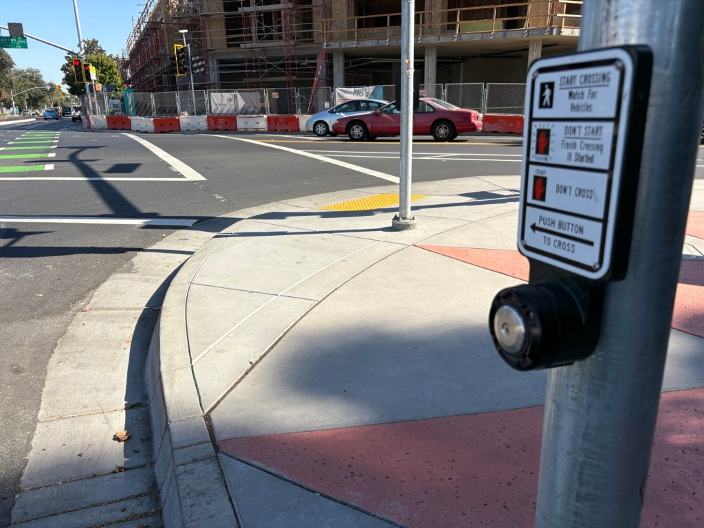
The bicycle signal face for Broadway eastbound at Land Park Drive/16th Street did not work for several weeks after it was turned on. Then it was ‘fixed’ so that it was part of every signal cycle. Now it has been further ‘fixed’ by the installation of a beg button which the bicyclist must press to trigger the bicycle signal. The beg button is the standard pedestrian button, it says nothing about bicyclists.
This signal should detect bicyclists and trigger the bicycle phase, without requiring any action by the bicyclist.
This is yet another example of the incompetence of city traffic engineers, who not only cannot design a signal that works properly, but will actively make things worse for bicyclists. Their concern is foremost, and only, with the free flow of motor vehicle traffic.
Bike signal for Broadway eastbound requires button push
I’ve written before that streets should be planned from the outside in. Nearly every street I travel and nearly every plan I see for changing street width allocation clearly shows that the reverse is what was built, and what is planned.
There are a number of streets where center turn lanes are provided in blocks where there are few to no driveways. S Street near where I live is just one example. Many blocks have few to no driveways, yet the center turn lane exists all the way from 3rd Street to Alhambra Blvd. Could the street width be better used? You bet.
The most egregious example, however, is the Broadway Complete Streets project. I’ve written quite a number of posts, about the ways in which the project is successful, and the ways in which is it not. The project is such a disappointment to all the transportation advocates I talk to. Why?
Broadway was planned from the inside out. A center turn lane, all the way, whether needed or not. I’ll point out the expression, “A foolish consistency is the hobgoblin of little minds”, Ralph Waldo Emerson, from the essay Self-Reliance“. Next, two motor vehicle lanes, one each way (which is an improvement over two each way before the project). The lanes are overly wide, 11 feet when they could have been 10 feet (not less than 10, because it is a bus route). Next, traditional bike lanes, mostly five feet wide but sometimes six, sometimes with a painted buffer (no vertical delineators), sometimes without. The bike lanes could have been parking protected, but they were not. They could have been wider, so that two bicyclists could safely pass each other, and accommodate cargo bikes and three-wheeled bikes. They were not. There is a short one block section between 15th Street and 16th Street where these a curb-protected bikeway. But nowhere else.
Then comes the sidewalks. The city apparently had a design policy to not touch the sidewalks, which then engenders ADA requirements, which are somewhat expensive to meet (though a small fraction of the entire project). But they did touch the sidewalks in places, and in each of these places, the sidewalks are narrower than they were before the project. In several locations, the sidewalks do not even meet ADA or PROWAG guidelines. The city has claimed that since PROWAG has not been adopted by FHWA, the requirements don’t apply to the city. In other words, go ahead and sue us, but we aren’t going to do the right thing. That is what city staff said when challenged about this.
Has the city learned its lesson? No. The two additional segments of Broadway to the east have exactly the same design.
The city’s stated objective for this project was to slow and reduce motor vehicle traffic so that people would stop for businesses along the street, increasing economic vitality. Broadway has real problems currently, as you can see by traveling along the corridor. A lot of empty buildings, a lot of parking lots, a lot of low value fast food joints. But is also has a number of great locally owned businesses, many of which were beginning to fail due to the street design and the pandemic. I admire the city’s intent, but mourn their failure to create a street than will accomplish that.
Additional posts on Broadway Complete Streets are available at category ‘Broadway Complete Streets‘.
On Broadway eastbound at Land Park Drive, there is a bicycle signal face, shown below. The signal is permanently red, it never changes to green. The presence or absence of bicyclists makes no difference; it does not change from red. This is confusing both motor vehicle drivers and bicyclists. Bicyclists wait for it to change, and it never does. Drivers wonder why bicyclists are proceeded along Broadway with the green ‘car’ light when the signal clearly says that they should not be proceeding. I have seen drivers yelling at bicyclists for going when it is not their turn, and this has been reported to me by a number of people.
This issue has been reported to the city, twice by myself, and multiple times by other people. It has been this way for at least two weeks, perhaps longer. The city has decided to ignore these reports and to not fix the issue. The city is endangering bicyclists, and is in fact legally liable for knowing that a safety hazard exists and doing nothing to respond. This is criminal behavior on the part of the city. Sorry to be so blunt, but when city employees, or contractors acting on behalf of the city, ignore a known and easily solvable safety problem, that is criminal behavior. Period.
This would be so easy for the city to temporarily solve, by covering the bicycle signal face so that it is not visible. The pedestrian crossing sign over Broadway at the east side of the intersection is covered, due to the construction on the corner closing the crosswalk. Beyond a temporary fix, the city needs to determine why the bicycle signal face is not working, and make it work.
Additional posts on Broadway Complete Streets are available at category ‘Broadway Complete Streets‘.
The section of Broadway from just west of 3rd Street to 19th Street has been repaved, and marked for striping, but no striping has been done yet. The section from 21st St to 24th Street has been ground down in preparation for paving, but no paving has occurred.
There are construction vertical delineators scattered all over the street, along with delineator bases without the vertical. Most of the delineators were placed in what will be the bike lane, not in what will be the bike lane buffer. Presumably the construction company wishes to keep them further away from motor vehicles, which is sort of understandable since more than one-third of the delineators have been hit by drivers.
I’ll post again when there is actual striping installed.
The Broadway Complete Streets project is underway, with new corners installed at many locations, some of them curb extensions (bulb-outs) to shorten crossing distance for walkers. Though I’m reluctant to criticize a project that is underway, I just can’t remain quiet. I have been spending a lot of time on Broadway because I’m interested in the street and its businesses, and always want to see how the city is shifting away from its former ‘cars first’ policy and design. Some of what I’m seeing is great, but I’m also seeing a lot that makes me very concerned, and disappointed. The city could have done much better, but decided not to.
Broadway near 19th St, south side, too narrow sidewalk
The project was designed from the inside out, first motor vehicle space for turn lanes, travel lanes, and parking lanes, then bicycle lanes. The result clearly shows this priority. But streets should be designed from the outside in, taking care first of the needs of people walking. The city did not do this.
The Broadway Complete Streets webpage says “The project location is the two-mile Broadway corridor between 3rd Street and 29th Street, south of downtown Sacramento, California. It anchors multi-modal transportation connections and improves access for all modes through introduction of a four lane to three lane road diet, new buffered bicycle lanes, new marked pedestrian crossings and refuge islands, and multi-modal improvements at two intersections”, and “The project is designed to calm traffic, improve safety, and make the street more inviting for travel on foot and by bicycle.” Notice that sidewalks are not specifically mentioned.
The pedestrian selection criteria from the 2016 Broadway Complete Streets Final Recommendations shows the following table. The third row (of eight) is ‘pedestrian space’, and it talks about space at ‘sidewalk enhancement locations’. But the document never indicates where these location are, nor mentions them again.
The plan cites as a critical issue: “Sidewalk obstructions or narrow sidewalks”. It also says, under transit improvement, not sidewalks: “Over time, opportunities for sidewalk expansion can be explored on blocks as appropriate. The Broadway Complete Streets Plan designs allow for conversion of the parking lane to an expanded sidewalk to create space for better bus amenities, landscaping, sidewalk dining, and other urban design elements.” What I think that means is that concrete for sidewalks and curbs will be poured now, and we’ll think about doing better later. The document refers to information about sidewalk widths in the existing conditions technical appendix, but that document has not been made available to the public.
The city’s Street Design Standards for sidewalks is five feet, or six feet for arterials. Broadway is a ‘minor arterial’ from 5th Street to 10th Street, and a ‘principal arterial’ from 10th Street to 29th Street, so the sidewalk width would be six feet. Existing sidewalks along Broadway vary greatly in width, from expansive, to wide sidewalks typical of the central city, to very narrow sidewalks. Of course there are locations where the sidewalk has been narrowed to accommodate tree growth, but the city is installing NEW sidewalk along Broadway that is less than city standards. The PROWAG requirements are four feet, but there are NEW sidewalks that are as little as 34 inches. The city’s project engineer has claimed that PROWAG does not need to be followed for this project because PROWAG is not enforceable yet. Seems strange to claim that because enforcement action can’t be taken, federally promulgated regulations don’t need to be followed.
The project is installing better crossings for walkers at several locations, but has pretty much ignored the needs of people walking ALONG the street. The design documents do not show sidewalk widths anywhere, though turn lane, traffic lane, parking lane, and bike lanes are clearly labeled with widths. It is as though the project design did not even think about sidewalks.
The city must correct its too-narrow sidewalks along Broadway. Where a parking lane is adjacent to these too narrow sections, the parking lane must be converted to sidewalk so as too provide the legally required width, or better yet, at least eight feet. If this is to be a complete street, and a walking-friendly and business-friendly street, then eight feet should be the minimum. If a parking lane is not available to convert, then the city must purchase property or easements to widen the sidewalks to the minimum five feet required by its own standards.
Additional posts on Broadway Complete Streets are available at category ‘Broadway Complete Streets‘.
Many of the corner ADA ramps already installed and to be installed as part of the Broadway Complete Streets project are diagonal ramps. Diagonal ramps were a common solution in the past for corners because they save a little bit of money, and sometimes avoid drain inlets that perpendicular ramp would conflict with. Changing drain inlet locations can be expensive. However, diagonal ramps have never been the optimal solution for corners, and since August 2023, they are not permitted under PROWAG (Public Right of Way Accessibility Guidelines), except under rare circumstances. In those rare circumstances, the ramp must be completely contained within the two crosswalks, which often leads to awkward crosswalks.
There are very few diagonal ramps in the Sacramento central city, so it is surprising that they will be so common at the edge of the central city, Broadway, as part of a complete streets project.
Some transportation agencies have been claiming that they don’t need to follow PROWAG since it has not yet been adopted by USDOJ and USDOT, however, that just means that it is not yet legally enforceable on agencies. But the regulation has been promulgated and published and is now the law.
The project engineer for Broadway Complete Streets has claimed that the diagonal ramps are specified because of “design constraints”. I have looked at every corner where a diagonal ramp was placed, and I see nothing that constitutes a constraint. It may be that what the city means is that it didn’t fit in the budget to install perpendicular ramps, but that is not a valid exception in PROWAG. It is worth remembering that the concrete being installed under this project will be in place for at least 30 years, so that means the city is constructing corners and ramps that are already outmoded, and will be far more so in 30 years.
Of the 15 locations that will have new diagonal ramps, and the 2 that apparently will be unchanged, the northwest corner of Broadway and 18th Street will serve as an example. The other three corners here have perpendicular ramps, but for unknown reasons, the northwest has a diagonal ramp.
Broadway & 18th St diagonal ramp
The diagram below, from NACTO, shows perpendicular ramps. Note also the tight turning radius, which slows turning drivers. Of course the optimal is if these ramps are contained within a curb extension, but even without that, they are a good practice.
NACTO perpendicular ramps
The next diagram snows perpendicular ramps in the context of curb extensions, and illustrates the huge benefit of curb extensions, which is increased visibility between walkers and roadway users. The curb extension also removes the need to paint the curb red or place a sign, one of which is required now under AB 413 (Lee, 2023). Caltrans includes curb extensions in its Pedestrian Safety Countermeasures Toolbox.
The table below shows the plan for each corner along the corridor from 3rd Street to 24th Street, with details about ramps and curb extensions. The plan I have does not include any change from the west side of 19th Street to the east side of 21st Street. This section includes the crossing between 19th and 20th by light rail and railroad tracks. It is unknown why this is.
Cross-street
NW
NE
SW
SE
Notes
3rd S
None
None
Diagonal existing
Diagonal new
No crosswalks
3rd N
Diagonal new
Diagonal existing
None
None
No crosswalks
5th
Perpendicular new
Perpendicular new
Perpendicular new
Perpendicular new
6th
Diagonal new
Perpendicular exist
None
Single
W crosswalk removed
Midblock
New, single with extensions
8th
Diagonal existing
Diagonal new
None
None
No crosswalks
Muir Way
None
None
Diagonal new
Diagonal new
No E crosswalk
9th
Diagonal new
Perpendicular exist
None
None
No crosswalks
10th
Perpendicular new
Perpendicular new
Single, extension
Single, extension
Riverside
Diagonal new
Diagonal new
Diagonal new
Diagonal new, extension
13th
Perpendicular exist
Perpendicular new, extension
Single
Single
14th
Perpendicular new, extension
Perpendicular new, extension
Perpendicular new, extension
Perpendicular new, extension
15th
Perpendicular new
Diagonal new
Single
None
No E crosswalk
16th/Land Park
Perpendicular new
Perpendicular new, extension
Diagonal new
Perpendicular new, extension
W crosswalk unknown
17th
Perpendicular new
Perpendicular new, extension
Diagonal new, extension
Perpendicular new, extension
W crosswalk removed
18th
Perpendicular new, extension
Diagonal new
Perpendicular new, extension
Perpendicular new, extension
19th
Unknown
20th
Unknown
21st
Unknown
22nd
Perpendicular new
Perpendicular new, extension
None
Single, extension
W crosswalk removed
23rd
Perpendicular new, extension
Perpendicular new, extension
Single, extension
None
W crosswalk only
24th
No change
No change
No change
No change
table of Broadway Complete Streets corners and curb extensions
This is Central City Mobility Project update #33. Note that 5th Street has not yet been converted from one-way to two-way.
When looking at 5th Street, part of the Central City Mobility Project to convert this from a one-way street to a two-way street, I was focused on the looking at the new signals and the mast arms. I failed to notice all the new beg buttons that have been installed. These are the ‘wave at’ variety. Installations are at Q Street, P Street, N Street and Capitol Mall. At Q, P, and N Streets, there are 8 new buttons per intersection. At Capitol Mall there are six, all on the east side of the intersection, because there is a pedestrian crossing prohibition on the west side. I don’t have documentation of what was here before these were installed, but I’m pretty sure that these intersections were on auto-recall, meaning that the button did not need to be pressed, or waved at. I have to admit I have been fooled again by City of Sacramento Public Works. I had been assuming that either things would remain the same, or things would get better. They have proved me wrong by making things worse.
5th St & Q St SE new wave beg button
There are beg button posts installed at R Street as well, but since this crossing of 5th St has not been activated, I don’t know how the beg buttons will be labeled.