Re-upping the Elvas Ave and Hornet Tunnel post from earlier this year. It has been reported to me by a number of bicyclists, and I have experienced it myself, that this section of Elvas between the Hornet Tunnel and the signal at 62nd Street has become significantly more hazardous due to the motor vehicle traffic generated by The Line (a collection of various food vendors, opened 2022) and Garden at the Line (an outdoor eating and drinking area adjacent to The Line, opened this December). There is a lot more come and go parking on Elvas, and a lot more motor vehicle traffic in and out of the parking lots. Most bicyclists ride on the sidewalk to avoid the fast-moving traffic, otherwise the crash rate would be higher. The M Street to Elvas Avenue to Hornet Tunnel route is probably the busiest in the city.
In addition to the previous post (reblog below) about the hazards for bicyclists, this area is now hazardous for walkers along and crossing Elvas.
I was there last night for the SABA social gathering, and the place was packed. People were parking along the west side of Elvas as well as on 63rd Avenue and 64th Avenue, and then trying to cross Elvas to Garden at the Line. It was nearly impossible to cross, as there are no marked crosswalks over Elvas at either street, drivers are going fast, and Elvas is not well lit. The speed limit in this section is 40 mph, which almost guarantees that walkers hit by cars will die. Sidewalks on both sides of Elvas are in poor condition, and rolled curbs are common, which are less safe for people walking than vertical curbs. There are no sidewalk buffers. While this section of Elvas is not one of the top 5 or top 10 Vision Zero corridors, it will quickly become so. In the last five years, there have been two injury crashes on this stretch, one bicyclist and one walker, both in the vicinity of Hornet Tunnel.
The city has no plans to improve safety for bicyclists or walkers on this stretch of Elvas.
The white line stripes that were added to the two blocks of P Street protected bikeway, 19th Street to 17th Street, are an attempt to keep leaf piles and trash cans out of the bikeway. I noted the added white stripes in Central City Mobility update #27, but wasn’t sure why they were added. The wording was added later. I have not yet observed this location on either a trash pickup day, or now that there are a lot more leaf piles. I have not seen the striping and marking on other blocks of the new bikeways, so this may be a pilot to see if it works. The practice of putting leaf piles in the regular Class 2 bike lanes in common, and the city has made no effort to reduce this practice.
On Wednesday afternoon, the sign below was on 21st Street approaching I Street. The sign was not there on Tuesday morning. If a bicycle signal was intended at this intersection in the design, why was it not signed earlier? Why wasn’t the signal already installed, since there was signal communications infrastructure installed at this intersection several weeks ago? Or was this a design oversight that the city decided to fix after being called out on it? And when is ‘coming soon’?
21st St at I St, sign for future bicycle signal
I observed bicyclist behavior at this location for a while on Tuesday. Every single bicyclist who was headed north on 21st Street crossed against the red light, so as to not be hit by left turning drivers who generally do not yield to anyone in the crosswalk, and then onto the sidewalk on the west side of the street, continuing through the area at Old Soul Weatherstone which is congested with tables and walkers. So the city has trained bicyclist to ride on the sidewalk. Those who have been so trained will be likely to continue sidewalk riding even after installation of the signal. Ouch!
Useless Turn Wedges
I have ridden 21st Street a number of times, to see how the project is progressing and to see how drivers are responding to the new layout. Most drivers are parking correctly in the parking that provides parking-protection for the bikeway, but a few continue to park against the curb. I’ve reported these to 311 for parking enforcement, but of course as always, parking enforcement reports that the vehicle is no longer there, whether it is or not.
Several times in a row drivers have turned across my path at high speed, left from 21st Street to L Street, over the green paint and the white turn wedge paint. At the times of day I was there, there were few to no parked cars, so I was clearly visible to the drivers, not in any way hidden. In both cases I had to slam on my brakes to avoid being hit by the drivers. They did not slow. The turn wedge diagram provided on the Central City Mobility Project page, shown below, clearly shows bumps and posts (vertical delineators) in the wedge. Without more detail, I can’t say whether these will actually affect driver behavior, but in general only hard curbs or real bollards (steel or concrete) actually affect driver behavior. In the meanwhile, drivers are being trained to turn across bicyclists, with impunity, and will not likely change their behavior when and if something is installed in the turn wedges.
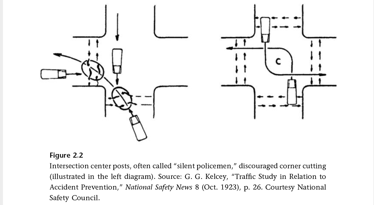
I have been reading Fighting Traffic by Peter Norton, and in Chapter 2 he introduces the concept of the outside left turn, which worked to prevent drivers from cutting the corner on left turns, and was later enforced with ‘silent policemen’, hard structures that provided serious consequences for drivers who insisted on cutting corners. Later, when motor vehicles were given dominance on the roadway, these were removed. It is time to bring these back!
Other
Striping and green paint is very nearly complete on 21st Street. 19th Street has been repaved and preliminary marking installed (the dashed white lines). P Street was just stripped for new pavement (I’m not sure what this process is called, removing 2 to 3 inches of old pavement so that new pavement can be laid), and is being repaved today (Thursday). Q Street has been patched but not stripped. I’m not noticing any active work on I Street, 5th Street, 9th Street, or 10th Street, though I Street has had ‘no parking’ signs up for some while.
The repaving is being done to the full width of the roadway, including the parking lane. This is a waste of materials and money. The parking lane does not need to be repaved, except in a few circumstances where it has been damaged. Nor does it need to be paved to the same standards as the general purpose travel lanes, which receive far more traffic and wear and tear. But the city loves pavement, and loves to add on unnecessary work to projects, ensuring that less is left for actual improvements to the street that would help walkers and bicyclists.
H Street is commonly used by bicyclists leaving Sacramento Valley Station, and others as well. It has decent bicycle facilities except for some gaps.
H Street has a bike lane on the south side from 5th Street to 16th St, except one block, 7th Street to 8th Street. There is absolutely no reason for this gap. This is the section between the Sacramento County Administration Building on the south and a decked parking garage on the north. The parking seems to be there for the convenience of people working in the building, as there does not seem to be turnover of the parking spots. There is ample parking in the garage. This parking should be removed and a bike lane painted IMMEDIATELY. No excuses. A common quote in the bicyclist community is “sharrows are bullshit”, and this is the case here, where the city has preferenced motor vehicle drivers over bicyclist safety.
H St parking and sharrows from 7th St to 8th St
There is a bike lane on the north side between 7th Street and 13th Street. Bike lanes on the left side of one-way streets are much less used than right side bike lanes, but are useful.
Next sharrows location to address is I Street between 10th Street and 9th Street. The bike lane present to the east disappears in this block, with Cesar Chavez Plaza on the south and Old City Hall on the north, before picking up again west of 9th Street. Not having my tape measure out (and I’d have to measure late night when there is no traffic), it isn’t clear why this one block does not have a bike lane. It may be that the curb extension is too wide, or it may be that the general purpose (car) lanes are not configured correctly. If lanes, then it is an easy problem to fix, just re-stripe the lanes and add a bike lane. If the curb extension, then that would require a bit of infrastructure work. I fully support curb extensions, nearly all intersections should have them, but in some places the city has installed them incorrectly and caused issues for bicycle facilities. This is not, as many places are, a case for removing parking, but for designing the street correctly. Of course ultimately there should be no three-lane one-way traffic sewers in the city, and right of way should be reallocated to a separated (protected) bikeway and wider sidewalks.
I St westbound at 10th St, Sacramento
Caveat: I post about issues in the central city because I live here, and see the problems every time I am out walking or bicycling. However, I strongly believe that the city should be focused on solving issues in lower income, disinvested neighborhoods, of which there are ample throughout the city. The central city has received more than its share of bike facilities.
City of Sacramento staff (Drew Hart) presented to the Sacramento Active Transportation Commission last Thursday on the Freeport Boulevard Emerging Design Concepts. The presentation slides are here. The city’s Freeport webpage has a lot of background material. A link to the virtual open house on April 28 (tomorrow!) is available. This project and the Northgate project are being supported by the same consultant, so you will notice similarities in the process and graphics.
The northern section, between Sutterville Road to the east and Sutterville Road to the west, should look exactly like the traffic-calmed, complete street to the north. This project on Freeport was successful. There is no reason for five lanes in this section. One lane northbound, one lane southbound, and one left turn lane southbound is all it needs. If traffic backs up at the Freeport and Sutterville Road to the east intersection, then shorten the signal cycle.
The emerging design document skips over the issue of whether four general purpose lanes are even needed. A concept should be presented that reduces general purpose lanes to two, and reallocates roadway width to other modes.
Dedicated right hand turn lanes should be removed everywhere. Dedicated left hand turn lanes should be provided only where traffic studies have shown a clear need, and should never reduce the roadway width for other uses.
Green lanes are shown behind protection for separated bikeways. Since the protection does or should prevent vehicle incursion, the paint is not needed.
Dedicated transit lanes should be considered. Though SacRT has not identified this as a high frequency route in the High Capacity Bus Service Study (Route 62 is 30-minute frequency), reconstruction of the roadway must consider the possibility of dedicated transit lanes and transit supporting infrastructure. Appendix A, available on the project webpage, provides a lot of detail about existing transit stops, which are mostly quite poor.
Some businesses along Freeport have multiple driveways, more than are justified by the amount of vehicle traffic access. Closure and narrowing of driveways should be considered. Since almost every business has parking fronting the street, no on-street parking is needed anywhere. This is poor urban design, but it is the nature of the corridor and could not be corrected without wholesale reconstruction of the corridor.
While separated bikeways are often a good solution, the frequency of driveways might make for poor quality infrastructure. Unless driveways can be closed or reconfigured, separated bikeways may not be the best solution.
Posted speed AND design speed should be considered for reduction. Posted speed is 30 mph from Sutterville Rd (to the east) to Arica Way, 35 mph from Arica Way to Fruitridge Rd, and 40 mph from Fruitridge Rd to Blair Ave. The section from Sutterville Rd (to the east) to Fruitridge Rd should be posted and designed for 25 mph, in recognition of the density of businesses and driveways. The section from Fruitridge to Blair Ave should be posted and designed for 30 mph, as it has a lower density of businesses and driveways, and is adjacent to the airport for a significant distance.
Prioritization of the modes for Sutterville (to the east) and Fruitridge Rd should be:
walking
bicycling
transit
motor vehicle
Prioritization of the modes for Fruitridge Rd to Blair Ave should be:
bicycling
transit
walking
motor vehicle
Crash/collision map of the Northgate Blvd corridor for pedestrians (walkers) and bicyclists. Data is from SWITRS for the years 2015-2019. (pdf)
Another classic mistake by the City of Sacramento. Re-striping was just done on several blocks of N Street. Eastbound on N Street 22nd Street, this is what it looks like.
N St eastbound at 22nd St
Take a close look. Extend the dashed line forward, and you’ll see the taper, from a regular bike lane adjacent to a parking lane, to just a bike lane. Look even closer. See where the no parking sign is? A vehicle can park that close to the intersection, completely blocking the bike lane, and in fact blocking part of the general purpose lane. Yesterday, when I rode by, but neglected to take a photo, there was a large pedestrian-killer pickup truck parked right up to the no parking sign, and it was actually covering up three of the dash marks. Riding a bicycle in the bike lane and expecting it to continue? In Sacramento, that is not a reasonable expectation.
I would hope that the striping crew, whether city or contractor (not sure which this was) would notice the problem and stop painting until this was clarified. But it is not really the responsibility of the stripers. This design was signed off on by a ‘professional’ engineer employed by the city. This is the quality of people the city employs.
Westbound on N Street, it is not as bad since the no parking sign is further from the intersection. See below.
N St westbound at 22nd St
It is still a poor design, but nowhere near as dangerous.
As I’ve said before (traffic calming in the central city), these median islands, when placed in this way, as a widening of the center line only at intersections, are a hazard to bicyclists, though they do provide some safety for pedestrians. The best traffic calming measure, and the one that should be used by the city, is traffic diverters.
Edit: Added graphics for El Camino – Grove intersection and Broadway – Stockton intersection, excerpted from the Sacramento Vision Zero Top 5 Corridors document.
The Sacramento city council will be considering the new Sacramento Vision Zero Top 5 Corridors document at the council meeting on Tuesday, February 15. It is item 11 on the consent agenda, so will not be discussed unless a council member pulls it from the consent agenda.
I have taken a look at the document, though the one included with the with the agenda is a flat file, not searchable, and with low resolution graphics, making it hard to use. When a high resolution and searchable version becomes available, I’ll link to it.
The document continues the pattern established in the 2018 Vision Zero Action Plan of focusing on corridors and not on intersections. The five segments presented as the top five are segments of El Camino Avenue, Marysville Road, Broadway/Stockton Blvd, Stockton Blvd south, and Florin Road. I believe that this exclusive focus on corridors is a mistake. Nearly all other vision zero communities have a dual focus on corridors and intersections, but Sacramento does not.
The Vision Zero Action Plan acknowledges on page 11 that 78% of collisions occur at intersections, but then seems to ignore this fact in pursuit of corridor projects. Of course if a corridor is done correctly, the intersections will be fixed as part of the project. The issue is that these corridor projects will cost millions of dollars and will require seeking state and federal grants to accomplish. The costs are El Camino $16,450,000, Marysville $12,850,000, Broadway/Stockton $8,750,000, Stockton South $9,500,000, and Florin $11,900,000. And these are only for the most important fixes; less important or more expensive fixes are somewhere off in the distant future. But a focus on the high injury intersections within the corridor could yield significant safety benefit at much lower cost, perhaps within the range of general fund expenditures.
This focus on corridors leads to some flaws in the corridor plans. On El Camino, the plan misses that there is a dropped bike lane at eastbound at Grove Avenue and therefore does not recommend the countermeasure Extend Bike Lane to Intersection. At the Broadway/Stockton intersection, the plan does not recommend the countermeasure Bike Conflict Zone Markings for Broadway eastbound and westbound approaching Stockton, and seems to completely drop the bike lane on Stockton northbound approaching, even though a bike lane is already present there.
El Camino Ave & Grove Ave intersectionBroadway & Stockton Blvd intersection
Re-striping of lanes at intersections and green paint could make many intersections a great deal safer without requiring expensive intersection reconstruction and new signals. I recently wrote about Dropped bike lanes, using Broadway/Stockton as an example. Paint could fix a lot of the problems here.
The concerns expressed here are with bicycle facilities. I actually think pedestrian (walker) facilities are more important, but it will take a lot more time to look closely at those.
The bicycle-related countermeasures recommended in the Vision Zero Top 5 Corridors are:
Bike Conflict Zone Markings: Green pavement within a bike lane to increase visibility of bicyclists and to reinforce bike priority. The green pavement is used as a spot treatment in conflict areas such as driveways.
Class II Bike Lanes: Five to seven foot wide designated lanes for ‘bicyclists adjacent to vehicle travel lanes, delineated with pavement markings.
Close Bike Lane Gap: Closing gaps between bike lanes increases the amount of dedicated facilities bicyclists can use, reducing mixing of bicyclists and drivers and Increasing network connectivity and visibility of bicyclists m the roadway.
Extend Bike Lane to Intersection: In locations where a bike lane is dropped due to the addition of a right tum pocket the intersection approach may be re-striped to allow for bicyclists to move to the left side of right-turning vehicles ahead of reaching the intersection.
Provide Green Time For Bikes: Provide or prolong the green phase when bicyclists are present to provide additional time for bicyclist to clear the intersection. Can occur automatically in the signal phasing or when prompted with bike detection. Topography should be considered in clearance time.
Remove Right Turn Slip Lane: Closing a free-flow right-turn slip lane can help slow right turning drivers, eliminates an uncontrolled crossing for pedestrians, and shortens pedestrian crossing distances. The space reclaimed in closing the slip lane can be reused as pedestrian widen sidewalks, enhance curb ramps, more space for street furniture.
Separated/Buffered Bikeway: Designated bike lanes, separated from vehicle traffic by a physical barrier usually bollards, landscaping, or parked cars. These facilities can increase safety by decreasing opportunities for crashing with overtaking vehicles, and reducing the risk of dooring.
Slow Green Wave: A series of traffic signals, coordinated to allow for slower vehicle travel speeds through several intersections along a corridor. Coordinating signals for slower travel speeds gives bicyclists and pedestrians mare time to cross safely and encourages drivers to travel at slower speeds.
I support the Vision Zero concept and city actions to support this, but I want to make sure that both are the best they can be. I hope to look in the near future at the pedestrian elements of the Vision Zero Top 5 Corridors, the Vision Zero School Safety Study, and the high-injury intersections in Sacramento that have been missed through a focus on corridors.
There are two low spots on the American River Parkway trail (officially called the Jedediah Smith Memorial Trail) that flood even under moderate rainfall or flood conditions. It may seem strange to bring these low spots up when just last week perhaps 90% of the trail was underwater. The trail is in a riparian area, and so will and should flood during major flood events. But the trail is also a major commuter route for hundreds people who work downtown and live to the east, as well as a few reverse commuters like myself. After the jump, details and solutions for these two problem spots.
Sacramento has nearly completed a reconstructed bridge over I-5 between 3rd Street and Tower Bridge. This is part of a project to provide access from and to Old Sacramento, but that part is not complete yet. The pavement is fresh, with bright white lines and green carpet bike lanes. But, the bike lane design is a failure. The eastbound bike lane is OK. A little strange because it varies in width, but acceptable. The westbound bike lane, though, is a hazard to bicyclists.
Below is a photo of the first problem, a bike lane to the right of a place where a right turn is permitted. This is at the entrance to the Old Sacramento access.The straight-and-right arrow indicates that the city expects heavy right turning traffic at this location.
While this design is in compliance with the law, using a dashed line to indicate that traffic from the general purpose lane and the bike lane should safely merge, the use of green paint here is the wrong message. Though green paint has no legal meaning, the general meaning taken is that this is the place for bicycles. So an average bicyclist will stay in the bike lane, not realizing that the safe manesuver is to merge into the general purpose lane. The result is a right hook danger that has been created by the design.
Stay to the right of right turning cars? NO!
There are a lot of ways to solve this issue, but this is the worst possible solution. Creating a separate signal phase for bicyclists and right turning traffic is one solution. Dropping the bike lane in favor of green-back sharrows in the general purpose lane is another.
However, this problem spot is minor in comparison to what happens just on the other side of the intersection. Here, the bike lane suddenly ends and becomes a right turn only lane. There is no signing for bicyclists or motor vehicle drivers, no pavement markings, no indication of what biyclists should do. I’m a vehicular bicyclist and would not be in this bike lane fragment to begin with, but for the average bicyclist, this green paint is a clear message, “this is where you belong.” Whoops. Sorry. Turns out we needed the road for a right turn lane, and just got rid of the bike lane. Hope you are still alive, but if not, well it wasn’t our fault. But the thing is, it is the city’s fault. This is a mis-design, and the city should be sued the first time someone is injured at this location. It is not as though this was an existing location where the city did the best if could to squeeze in bike facilities. This is a new construction where things should have been done right. They were not.
Bike lane ends suddenly – good luck!
There are several good solutions for this location, and the NACTO Guide to Urban Bicycling has several, but even the standard MUTCD design is better than this. Though you can’t see the turn lane due to the parked FedEx van (it was there for more than 10 minutes, double-parked, and I couldn’t wait any longer for the photo), there are no bike markings in the right turn lane at all. There is no “bicyclists may use full lane” sign. Maybe bicyclists are meant to fly over this right turn lane and return to earth at the bridge. Or maybe they are meant to die.
As I always warn people in bicyclist education classes, don’t get sucked in by paint. Paint doesn’t keep you safe. And in this particular case, paint creates a danger for you that would not exist if not for the paint. Negligent design, for sure.