This is a typical car-brained response to solve an issue. While it is true that a car trip to the airport has a fraction of the carbon impact that your flight has, nevertheless, it is possible to get to the airport without touching a car, your own or ride-hail.
SacRT has Route 142, once an hour, and Yolobus has Route 42A/42B, once an hour or better. Though the schedules are not fully integrated (yet), this results in about 30 minute service frequency to and from the airport. SacRT’s buses are electric, and take about 20 minutes for a trip from downtown to the airport, without stops, while Yolobus’s are fossil fuel, and take about 20 minutes for the trip, downtown Sacramento to the airport. The clockwise/counterclockwise loop buses also serve Davis and Woodland.
You can plan your trip with Google Maps or the Transit app (highly recommended).
How much does it cost? SacRT $2.50 per ride (and 90 minute transfer) or $1.25 discount, or free for K-12 students. Yolobus $2.25 or $1 discount. Compare that to parking at the airport, $2/30 minutes, with a maximum of $10/day up to $30/day. Ride-hail? $30 to $168, depending on time of day and surge pricing, according to the Bee article. Want to throw your money away for perceiving convenience? Go ahead.
So, get out of your car, or anyone’s car, and on to the bus. And leave your car-brain behind.
Total travel time matters, not just in-vehicle time: Not sure how the Green Line measures up, but it is indicative that the Green Line to Township 9 (the current destination) runs on an infrequent schedule (60 minutes) during a small part of the day, because it is beyond the area where most people travel. The airport would also be beyond where most people travel, so is likely to have infrequent and short hours service.
Combine air travelers and airport employees on the same train/bus: The Green Line might do OK on this, though light rail already suffers from the perception of higher income people (which is mostly who flies rather than takes the bus or train) that light rail is only for poor people.
Connect the airport to lots of places, not just downtown, by providing a total network: Since the SacRT network fails pretty badly on connectivity already, it is likely that the Green Line will suffer from the same issue.
Don’t interfere with the growth of other services: The Green Line is definitely a negative on this issue. The Green Line to the Airport would gobble up all the construction funds for years, as well as a large slice of operating funds. Fare recovery on the network is 23%, somewhat below average, but the extension would likely reduce this significantly. If distance-based fares (which SacRT has talked about but done no real planning towards) are implemented on the light rail system, the operating subsidy might be less, but it will still compare poorly with the rest of the system.
If you can afford it, go via the airport instead of terminating there: Not applicable to the Green Line because there is nothing beyond the airport except agricultural fields, and a bit further out, sprawling suburbs that would never generate ridership.
I think the right solution for airport access is frequent bus service (15 minute frequency) from downtown to the airport, from 5:00AM to 12:00 midnight, for travelers and airport employees, and less frequent service from midnight to 5:00AM, for employees. The current Yolobus 42A/42B provides infrequent (60 minute) service from 5:30AM (6:30AM on weekends) to 10:00PM. In addition, there would need to be service from eastern Sacramento/Roseville, but I’ve thought less about how that would work.
Save our infrastructure funds for more productive routes!
I attended the open house meeting hosted by SacRT and it’s consultants this evening at the Sacramento Central Library, as did about 60 others. I’ve written before about the green line extension (the green line currently ends at Township 9 on Richardson), so I’ll just add a few comments now, on the bridge, multi-modal transit trips, the airport, and the EIR.
Bridge: The bridge over the American River, between Township 9 and Truxel Blvd, is a key issue. Will it be multi-modal, for light rail, pedestrians and bicyclists, or will it be all-modes, including private motor vehicles? There are good arguments for both. A multi-modal bridge would send a message that we value these transport modes more highly than motor vehicles, and it would be a great deal less expensive. On the other hand, Sacramento is somewhat isolated by the paucity of bridges over both rivers, and this might be a chance to disperse traffic to a new route. However, more lanes generally induce more traffic, and become congested, and lead to higher GHG emissions that both work against climate mitigation and undo the other good things we are doing. The planning does not seem to be far enough along to have any cost estimates for the bridge alternatives. The consultant at the bridge display was a fill-in, not the bridge engineer, so it wasn’t possible tonight to get any more detailed information. The recently completed rail-ped-bicycle bridge over the Willamette River in Oregon did not include motor vehicle traffic in part because it would have greatly increased the cost of the bridge. I suspect that both the city and SacRT will claim that the all-modes bridge is not significantly more expensive, but this claim needs to be watched closely and perhaps challenged.
Multi-modal transit trips and bicycles: SacRT just does not seem to get that almost all transit trips are multi-modal, as they include walking and bicycling at one or both ends of the trip. There was no mention at any of the displays of providing on-demand bicycle storage at stations, and discussions with several SacRT staff indicated that it wasn’t something they were even thinking of. The center platforms (boarding in the middle, tracks on the outside) to be used in several locations won’t even allow space for bike storage of any sort. I believe the only thing that will get North Natomas commuters out of their cars is if they can ride their bike to and from the station (there are some great paths, and some of the arterials are not horrible), leaving it there for the day because they don’t need it at the downtown or Folsom end where they work. The failure of SacRT to provide on-demand, secure bicycle storage has been raised by myself and many others for years, but still nothing has happened. The on-demand BikeLink lockers and station on the Folsom line were purchased and are managed by the City of Folsom, not by SacRT. I will suggest that a light rail line to North Natomas will fail if on-demand bicycle storage is not provided. SacRT only needs to visit the bay area systems to see that no one is any longer building or revising stations, or providing or updating rail cars, without serious provision for bicyclists.
Airport: Why does light rail need to go to the airport? I’m not sure that anyone has a financially sound reason for it. The line would go through miles of empty farm and ranch land. Will this land eventually be developed? Perhaps, but not likely. The GHG implications of this type of sprawl development will at some point stop it in its tracks, and at least some of the agricultural land will remain as such. Sure, cities like to be able to say they have transit to the airport, but in two places I visit where light rail does go to the airport, Portland and Seattle (both high-transit use locations), most people still drive to and from the airport. Both lines have large numbers of intermediate stations that serve many users beside airport customers, but the green line would not. In a less transit-oriented place like Sacramento, how many people will use the airport extension? And at what cost per passenger? If we had unlimited funds, I’d be all for an airport extension, but we don’t have unlimited funds, and an extension to the airport greatly delays, or perhaps kills, extensions to ARC, Roseville, Elk Grove and Davis.
EIR: The environmental impact report will have to cover the entire extension to the airport, because projects cannot be considered piecemeal, but there is a danger that ONLY the entire project will be analyzed, and that the segments will not also be analyzed separately. As I’ve said before, I think there is a clear justification for the extension to South Natomas (stopping south of I-80), there may be justification for segment to North Natomas, if the system can be designed in such a way that it will actually be used by the car-centric residents of North Natomas, and there is little justification for the segment to the airport. If the segments are analyzed separately in addition to as-a-whole, then people will be able to better judge the impacts and benefits of the extension.
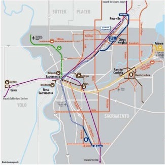
Reconnecting America, a transportation advocacy organization, just published Transit Space Race 2013. To see the Sacramento area projects, click on the < 3 million tab, and then sort by state. The eleven projects will be at the top of the list. The transit agency link in the right-most column links back to a page or website about the project.
Though the south corridor extension is shown as engineering in the status column, construction is underway on parts of the extension, the two bridges, and will start soon on other parts, with the help of a recent federal grant as well as regional funds. The airport extension and streetcar projects also have their own webpages.
Most of the other projects link to the Sacramento TransitAction Plan, which show all possible projects in Scenario C (map at right, more detail in the plan starting on page 50). This plan does not give much detail on each project, but the name of the project gives you an idea.