The City of Sacramento has released the final draft Freeport Blvd Transportation Plan. Appendix F Design Layouts is a key part of the document. This post reflects my original comments (Freeport Boulevard Emerging Design Concepts) and the new plan. The city’s plan page is at http://www.cityofsacramento.org/Public-Works/Transportation/Planning-Projects/Freeport-Blvd-Corridor. The plan is on the Active Transportation Commission agenda for January 20, 2023, and will go to the city council within the next two months.
The ten common design elements on page 21 (24 of the pdf) include: “10. Maintained necessary travel lanes, turn lanes, and parking: Maintaining travel lanes and turn lanes ensures that drivers traveling along the corridor will not be compromised, and preserving parking spaces where 5 the utilization is higher so it serves better adjoining businesses.” This is statement is contrary to all walkability, bikeability and vision zero goals. It should be removed from the document, and removed from planning goals. It is offensive. It means that no matter what other improvements to the corridor will be made, cars and motor vehicle drivers will be preferenced over all others.
The ten common design elements do not mention trees. Trees are an integral part of the walking experience, as well as providing climate and heat island benefits. They should be prominently recognized throughout the document, but they are not. The phrase ‘existing trees’ occurs many time in the document, but nowhere are ‘proposed trees’ identified.
Frequent driveways along much of this section present hazards to walkers and bicyclists, and handicap the design of safe streets. It is clear that the city did not consider reduction or narrowing of driveways to address this hazard. If you look at the design layouts (Appendix F), the number of gaps in the bikeway, shown as dashed green, is remarkable. Each of these is a driveway. Again, this is a clear indication that the city intended to maintain the car-dominated character of this street.
All crosswalks at intersections should contain all three or four legs (three for T-intersections). The design leaves many intersections with only one crosswalk over Freeport Blvd, meaning pedestrians must cross three streets in order to reach some destinations, rather than just one. Though not mentioned in the plan, this often means installing pedestrian crossing prohibition signs and barriers. These should be outlawed, not encouraged.
North Section
pages 25-26 (28-29 in the pdf)
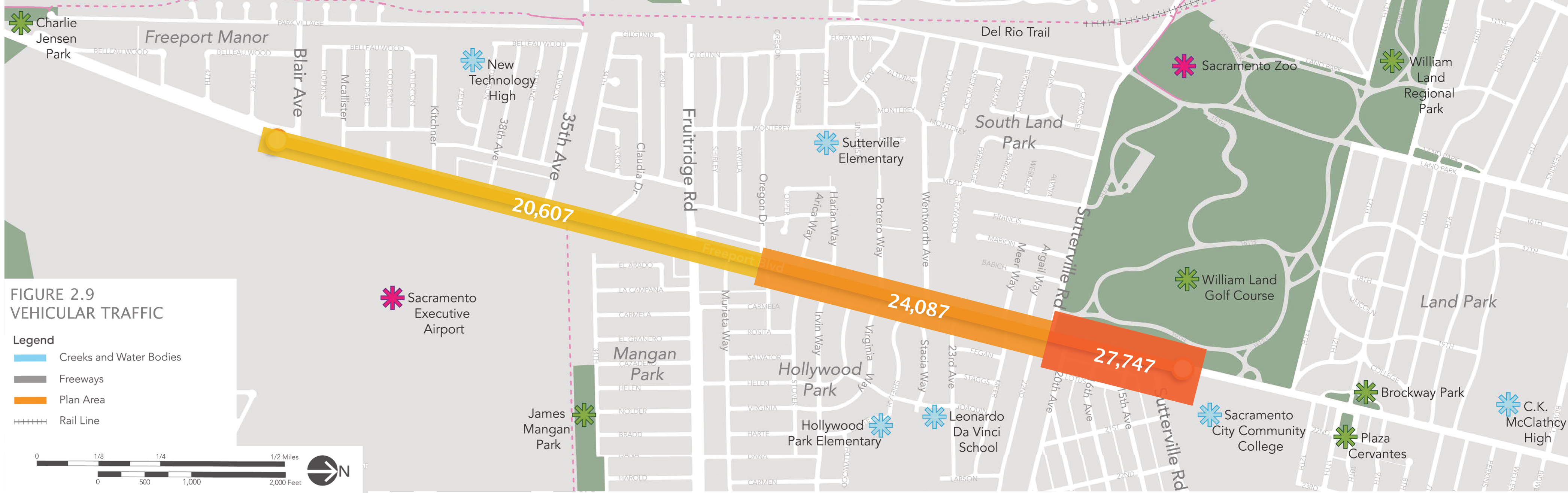
The intersection of Sutterville Road to the east with Freeport Blvd is shown with a two-lane roundabout. Two lane roundabouts have almost none of the traffic calming and safety benefits of one lane roundabouts, in fact they should not even be called roundabouts, with the implication that they have safety benefits. This roundabout should be redesigned to a single-lane. Traffic levels on Freeport to the north certainly do not justify two lanes, in fact Freeport become single lane each direction a short distance to the north at 13th Avenue.
The dedicated right turn lane on Freeport Blvd southbound at Sutterville Road to the west is not needed and presents an unnecessary hazard to bicyclists. Dedicated right turn lanes should be eliminated from this plan, and from all city roadways. They are rarely justified by traffic volume, create conflicts for bicyclists, and widen roadways and therefore crossing distances for walkers. They also encourage drivers to make right hand turns without looking for people walking.
There should be a crosswalk on the north side of the Freeport-Sutterville intersection. There is no justification for leaving it out, unless an attempt to discourage walkers from accessing the park.
South Section
pages 27-31 (30-34 in the pdf)
The offset crosswalks with median refuge at Oregon Drive and Potrero Way/Virginia Way are a good design, but there is no reason to not provide crosswalks on the other leg of the intersection.
The median gap at Arica Way, with dedicated left turn lanes, is not needed. Arica Way is a low volume street that is a good candidate for right in/right out treatment. The shopping center access can be provided for northbound traffic.
At the intersection of Fruitridge Blvd and Freeport, there should be no dedicated right turn lanes. They create a hazard for bicyclists, that cannot be mitigated by pavement marking, and they lengthen the crossing distance for walkers. In this location, where center refuge medians are not proposed, this is particularly egregious. The dual left turn lanes southbound on Freeport are a hazard to bicyclists and motor vehicles, and should be reduced to a single left turn lane. This intersection, due to long crossing distances, should provide center refuge medians on both the north and south crosswalks.