There are a few streets in Sacramento which are wide enough to host many activities and modes of travel, with reallocation of the roadway width to meet a new vision of a livable, walkable city. Two NACTO diagrams are below. The first, a downtown one-way street, is interesting to me because it shows a better use of space without having to change from one-way to two-way. I have always been opposed to one-way multiple lane streets because they present the multi-lane threat to people crossing the street, when one driver stops but others do not. This is one of the most common causes of fatalities for walkers, and why it must be eliminated. However, if the design is changed, the street becomes much safer, and the multi-lane threat is reduced or eliminated. Check the NACTO page for an alternate design.
NACTO downtown one-way street
I believe there should be high frequency bus service on J Street from 5th St to the university, and if J Street remains one-way, paired service on L St. This diagram would be a great model. Current service is 15-minute frequency on part of the route, but only 30-minute on part. Service should be at least 10-minute, maybe even more frequent. This would be a good design for that service and for those streets. Yes, L Street is not continuous, due to a broken street grid, so either H Street or Folsom Blvd could be used to connect.
Other streets that might remain one-way, but only with redesign, include the 9th-10th couplet, 15th-16th couplet, 19th-21st couplet, and P-Q couplet. The W-X couplet that bounds the Hwy 50 freeway would have to remain one-way due to freeway onramps and off ramps, but must be narrowed significantly. It is nothing but a traffic sewer as currently designed, and the motor vehicle capacity of the street is completely unneeded, even during rush hours.
The street has typical modes: motor vehicle lanes, bicycle lanes, parking areas, wide sidewalks. Features include curb extensions, short left turn lanes but long center medians, pedestrian scale and intersection lighting, planting strips with trees, but perhaps less than the yield street. The most important aspect is that there is only one general purpose travel lane per direction, meaning that the prudent driver controls the speed of other drivers. The design speed and posted speed might be as high as 30 mph, but would probably be less.
NACTO (National Association of City Transportation Officials) is the lead organization for progressive transportation cities. It is in strong contrast to regressive organizations such as League of California Cities which exist primarily to serve suburban areas. Of course part of the difference is the size of the cities, as NACTO tends to include large cities, while League of California Cites tends to include small cities, but it is really a difference in attitude about what cities are for. NACTO cities are cities for people, League cities are cities for cars and businesses. Take a look at CalCities Partners to see who the League likes. Unfortunately, City of Sacramento is a member. But on the plus side, Sacramento is also a member of NACTO.
In upcoming posts about Street Design Standards, I will be using NACTO materials often, primarily from the Urban Street Design Guide, but from the Transit Streets Design Guide and Urban Bikeways Design Guide as well.
I believe that the Street Design Standards should include both overviews of different kinds of streets, to provide city staff, city council, and most importantly, the public, a clear picture of what a new or reconstructed street will look like and feel like. Design details are also important, but design details without context just allow staff to build streets that follow the rules but neglect safety and livability.
So, first up, the overall design that NACTO calls a Yield Street. The portion of the street devoted to moving motor vehicles is less than most of the streets in Sacramento, but the portion devoted to street-related uses is more. The most prominent difference is that the travel part of the street is not two lanes, but a shared area (hence, the yield name) where drivers must negotiate to pass and adjust for variable widths as parking and other uses vary. This is easily a street for a 20 mph design and posted speed limit, as all local streets should be. Note also: wide planting strips with trees, perpendicular ADA ramps, high visibility crosswalks, curb extensions on most corners, small corner radii, pedestrian scaled lighting, and reduced but not eliminated parking. The diagram shows just residential uses, but the design can easily accommodate corner stores.
I have decided to start a series on street design ideas and standards, as a support for the City of Sacramento update of its Street Design Standards, due to occur this calendar year. I would hope that the city would actually engage citizens and transportation experts in the development of the standards, though it is more likely that the city will present a late-draft-stage document for review. In either case, I hope to educate the public about what good street design looks like and functions like, so that they can provide useful input and demand the highest level of design safety and innovation from the city.
The posts will be available under the category ‘Street Design Standards‘. Though this is a subcategory of City of Sacramento, the posts will almost entirely be applicable to any city or county.
First up, existing design standards and concepts. The horrible state of our transportation system is due in large part to the practice of traffic engineers using highway design ideas on urban streets. These designs have encouraged traffic violence, reduced the livability and economic vitality of cities, and created infrastructure that we will never have the funds to properly maintain. And, most importantly, then have killed millions of people and maimed at hundreds of millions more.
If you have not read it yet, I can’t more highly recommend Confessions of a Recovering Engineer by Chuck Marohn, founder of Strong Towns, for a review of the traffic engineering malfeasance and embedded but never explicit values that got us to this point.
There are a number of existing publications and resources for designing streets, some of them useful, and some us them which got us into this mess to begin with. Here are the ones I recommend that the city use, and not use:
CA-MUTCD concepts or designs will not be used for urban streets without compelling research-based evidence that they are safe for this context. Many of them are not. (https://dot.ca.gov/programs/safety-programs/camutcd)
AASHTO A Policy on Geometric Design of Highways and Streets (Green Book) concepts or designs will not be used for urban streets because it is not freely available to the public
In the city’s 311 website and app, the following 10 options are listed under Parking: Enforcement Request:
Blocking Alley
Blocking Driveway
Commercial Vehicle in Residential Zone
Parked Beyond Posted Time
Parked in Disabled Space Without Placard
Parked On Unpaved Surface
Parked without Permit
Red Zone
White Zone
Other
Blocking a crosswalk is not listed. Is this a mere oversight? I doubt it. I have reported dozens of vehicles parked blocking crosswalks, and not a single one has resulted in a citation. Apparently the city does not consider this a citable violation. One time I actually waited at the crosswalk where a vehicle was parked in violation. The parking officer drove up, noticed the vehicle blocking the crosswalk, and drove away. The 311 request was marked closed with the note that the vehicle was no longer there. But of course it was, and the parking officer knew that it was.
California Vehicle Code (CVC) Division 11: Rules of the Road, Chapter 5: Pedestrians’ Rights and Duties, paragraph 21970 states:
(a) No person may stop a vehicle unnecessarily in a manner that causes the vehicle to block a marked or unmarked crosswalk or sidewalk.
In addition, paragraph 22500 states:
A person shall not stop, park, or leave standing any vehicle whether attended or unattended, except when necessary to avoid conflict with other traffic or in compliance with the directions of a peace officer or official traffic control device, in any of the following places:
(b) On a crosswalk, except that a bus engaged as a common carrier or a taxicab may stop in an unmarked crosswalk to load or unload passengers when authorized by the legislative body of a city pursuant to an ordinance.
The city should do two things: 1) add ‘Blocking Crosswalk’ to the 311 website and app; and 2) actually enforce this CVC.
This is yet another example of the city’s bias toward motor vehicle drivers and against people walking. Please join me in emailing the city’s Parking Services at ParkingCSR@cityofsacramento.org, and requesting that the city add this violation to the 311 website and app, and that violations be cited when reported or observed.
If you would like some copy and paste text:
I request that the City of Sacramento Parking Services:
Add ‘Blocking Crosswalk’ to the list of parking violations in the 311 website and app. This is a violation of CVC 21970 and CVC 22500.
Issue citations to vehicles blocking crosswalks, in order to protect the safety of walkers using crosswalk.
Before delving into street design, I must come back to the question of whose responsibility it is to maintain sidewalks. I’ve talked about this before, Sacramento and sidewalks, but it bears repeating. It also deserves a citizen movement to force the city to change policy.
deteriorated sidewalk, 24th St near Capitol Ave, Sacramento
Take a look at the city’s Sidewalks, Curbs & Gutters page. Unless you are a confirmed windshield perspectives, cars-first and cars-only person, I think it will strike you as strange.
Start with the opening paragraph, which tells a lie. “Within the City of Sacramento, there are approximately 2,300 miles of sidewalk. Sacramento City Code, section 12.32, and California Streets & Highway Code 5610 requires that the maintenance and repair of public sidewalks be the responsibility of the property owner.” Streets and Highways code does NOT require that maintenance be the responsibility of the property owner. It simple allows a city to try to make it the responsibility of the property owner. Not all cities do that. But Sacramento has decided that shifting responsibility for transportation infrastructure in the public right-of-way to property owners fits the model of car dominance that is essentially city policy.
Let me offer some paragraphs, with the only change being replacement of ‘sidewalk’ with ‘street’.
“…requires that the maintenance and repair of public streets be the responsibility of the property owner.… If the property owner does not take action in one of the above three ways, the City will make repairs under default and the cost will be collected from the property owner. Unpaid collection will ultimately lead to a lien on the property.”
“As the property owner may bear civil liability for a person suffering personal injury or property damage caused by a defective street: it is in the property owners best interest to maintain the street and reduce the risk of a lawsuit.”
“City ordinance requires property owners to take responsibility for street repairs, regardless of whether or not the tree’s roots causing damage is City owned.”
“An owner shall maintain and repair any defective street fronting such owner’s lot, lots or portion of a lot. Where a defective street is caused in whole or in part by a tree root or roots, the owner shall nevertheless have the duty to repair the street.“
Sounds absurd, doesn’t it? And it is absurd. Sidewalks are an integral part of the transportation system in the city. In fact, for people with disabilities who use mobility devices, they are the ONLY way of travel in the city. So trying to force responsibility for sidewalks onto property owners is a violation of at least the intent of ADA regulations, and perhaps the actual legal force of ADA regulations.
Beyond the arguments of fairness in sidewalk policies, there is the real issue that it simply does not work. There are broken sidewalks all over the central city, and the further out one goes, the worse they are. There are sidewalk defects that have been there the entire 12 years I’ve lived in the central city. There is a clear pattern that sidewalks in front of residential property are much more likely to get repaired than in front of commercial properties, reflecting a bias in enforcment.
Some lower income neighborhoods have such poor sidewalks (not to mention narrow sidewalks of 3-4 feet) that everyone walks in the street instead. If the city’s bias against walkers and the disabled is clear, its bias against lower income neighborhoods is glaring.
Even if the city’s policy on sidewalk repair were morally right, which it clearly is not, it is a failure to serve citizens of the city. And it is as clear a statement of bias in favor the drivers of motor vehicles as one can find. It is time for it to end.
I had recently posted on the design for alley sidewalk crossings, based on a document from the City of Sacramento website. I shortly thereafter discovered that there are at least two sets of standards. The Department of Utilities, on the Development Standards page, has a Standard Specifications document which includes some text about streets, and the Transportation appendix of standard drawings which contains the diagram referenced. If you look at the text document, you will notice that it does not link itself to the Department of Utilities. Who wrote it, who would you contact about it? Who knows. Why the Department of Utilities has its own designs, separate from Department of Public Works, which has assigned responsibility for transportation, isn’t clear at all. On the positive side, though, this document was updated November 2020.
The Department of Public Works has its own Section 15 – Street Design Standards, part of the Design and Procedures Manual, linked on the Public Works Publications page. This is the document I discovered after using the Department of Utilities document. On the negative side, this document was last updated in June of 2009. Fourteen years ago. Again, there is no attribution to department in the body of the document. I only know/think this is a Public Works document because it is linked from a PW page.
There have been immense changes in street design best practices in that time. Most of the diagrams are overviews of arterial and collector roadways, very little about other streets. Bike lanes of any sort? Nada. ADA ramp details? Nada. Protected intersections? Nada. Curb extensions (bulb-outs)? Nada. Traffic calming infrastructure? Nada. The text of the document does contain references to a few of these issues, but without corresponding diagrams, there really is no guidance at all.
In searching for design diagrams, it appears there are additional designs scattered across the city website, some of them having to do with subdivisions, which seem to be treated separately from other street design. Let me say that this is not at all clear. The city website contains many documents without attribution to the department which created it. The city search engine is one of the poorest I’ve ever seen, and when it finds a document, it is almost impossible to tell where it came from or on which webpage one might find it.
At the SacATC (City of Sacramento Active Transportation Commission) meeting on 2023-03-16, staff presented an Introduction to Current Active Transportation Efforts. Under Projects, item 6 is ‘Street Design Standards Update: website expected in Fall 2023’. I spoke at the meeting about the weakness and antiquity of the current standards, and about the confusion over which set of standards is being talked about. City code, in Title 17 Planning and Development Code also has references to street design, but no linkage to the corresponding street design documents or diagrams. I don’t think staff realized how big a mess this is. It is not just the Public Works document that needs to be updated, but all city references to street design pulled together and properly referenced and linked.
A post in the near future will provide my ideas about what a street design manual ought to look like.
The Parking Reform Network (PRN) website on parking minimums (also called mandates) and minimums has been recently updated and enhanced. Take a look!
I have in the past worked to compile information about parking in the central city, but it turned out to be more complex that I had realized and I never completed it. It is fairly easy to map surface parking lots, that lowest common denominator of land use, but mapping parking garages is more complicated because many of them have commercial at street level, so are not all parking, and many developments have either underground or parking in the middle of the building. All of these are much harder to document and map. So I am glad that PRN, with partner Strong Towns, is mapping.
You can see the primary map at Parking Lot Map. Use the city pulldown if you don’t go directly to Sacramento. Note that this map covers just most of downtown, it does not cover the entire central city, nor any of the rest of the city. Be sure to click on the ‘View More’ button, which provide detail that is difficult to find elsewhere, including on the city’s own website.
PRN parking lot map of ‘central city’ Sacramento
The city’s 2021 Housing Element includes policy H-1.4: Facilitate Infill Housing Development. The City shall facilitate infill housing along commercial corridors, near employment centers, near high-frequency transit areas, and in all zones that allow residential development as a way to revitalize commercial corridors, promote walkability and increased transit ridership, and provide increased housing options . (page 23)
The implementation chapter of the housing element includes Program H8. Revisions to Parking Requirements (page 46) that is included in the PRN website. The general plan update for 2040, which would implement this program, has been delayed beyond 2022. The city has not provided a target date, so far as I know.
As I was walking this afternoon, crossing 19th Street at S Street, with the light, a woman very nearly ran me over. She was looking only at opposing traffic, and decided she could make the left turn if she accelerated. She was not looking at the crosswalk or at me. In fact, I’m pretty sure she would not have seen me until I was on her hood. She only noticed me because I screamed at her as I jumped back to avoid being hit.
This is a story that anyone who walks could repeat, it is not in the least unique. I have probably 150 almost identical instances since moving to Sacramento 11 years ago. And it is not unique to Sacramento. Traffic violence is everywhere, almost all the time.
But as I continued my walk, I wondered what goes through the minds of drivers who almost kill people. In many cases, they blame it on the person walking, for having the effrontery of being on the street in front of their car. I know this because they often start the screaming, directing invective at me.
But what about the others? Do they drive more carefully, with more attention to surroundings? Do they refrain from accelerating into dangerous situations? Do they slow the fuck down? Probably, for a few days. I imagine some of these drivers are actually quite shaken by the realization that they almost killed someone.
I’m pretty sure that it doesn’t last, though. They must slide back into their old reckless ways. If this were not so, there would be much more careful drivers on the road, and much less traffic violence. But there isn’t.
I suspect almost every driver on the road has come close to killing someone before. Some drivers, many times. Some drivers have killed people walking. After all, killing someone with your vehicle is seen by law enforcement and courts as a whoopsie, unless you are very drunk.
Note that I define traffic violence as any driver behavior that intimidates people from walking or bicycling. The driver doesn’t have to actually kill or injure to have the (desired?) effect.
Note: Please see post on City of Sacramento Street Design Standards. It turns out that there are at least two different sets of design standards.
The City of Sacramento has Standard Specifications and Drawings that require certain designs for the public right-of-way. There were last revised April 2020, and are available on the Utilities: Development Standards page. It is not clear why these are part of Utilities rather than Public Works or Community Development, but they are. Though I haven’t done an element by element comparison, they seem to be a considerable improvement over the previous standards, which seem to be June 2009.
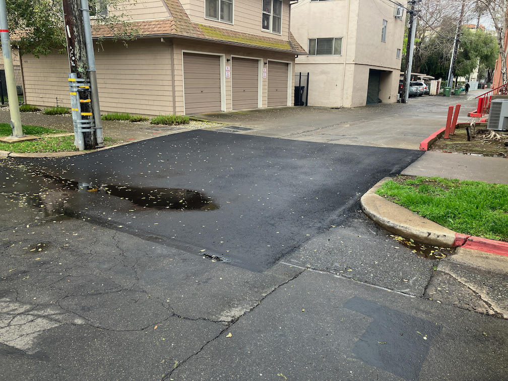
There are designs which are not being followed, and others that should be eliminated. Today, I’ll address sidewalks crossing alleys. Alleys are only common in the central city, but they do exist other places throughout the city.
The city design standard is below (pdf of entire page). The detail is hard to see, but the alleyway, sidewalk, and alley driveway are all concrete, none are asphalt. The T-11 Standard Alley Entrance Detail page says “Portland Cement Concrete (PCC) is the city standard pavement for alleys.”
SacCity Specification detail alley entrance
Of course there are many alleyways that are asphalt, and some that are unpaved gravel. I don’t know when the city standards changed to require pavement, or when to require concrete, but those are the current standards. That means that if an alley, or a sidewalk, or the alley driveway is changed, it must meet current standards. Below is a photo of Neighbors Alley at 17th Street, which was just redone within the last two months. It clearly does not meet city standards. Both the driveway and the sidewalk are asphalt, not concrete. Though I noticed this work being done, I failed to notice who was doing it. City? Private? Private utility? Not sure.