Three orientation webinars (scroll down the page above to the webinar signups)
The plan itself, available as a pdf on the General Plan page. The Climate Action and Adaptation Plan is also available there.
A number of organizations. and individuals, will be reviewing the plan, and providing information to their members. Dive in if you have the time, or wait for some guidance from others.
The General Plan is probably the most important document that the city will put out, since it will address zoning changes to allow more housing, and more affordable housing, which helps every other aspect of livability in the city.
California Assembly Bill ‘AB-645: Vehicles: speed safety system pilot program‘ is going to be before the Assembly Appropriations Committee shortly. Though it breezed through the Assembly Transportation Committee, it faces challenges in Appropriations. Chair Rendon is rarely a supporter of safe streets, and has killed a lot of street safety bills in his committee, so it is important that the public make it clear how important this bill is.
The bill would establish a pilot program in six cities. The City of Sacramento is not part of the pilot program (I think because the city did not request that it be), but the pilot results will be critical to implementing the program statewide. There are a tremendous number of privacy protections built into the program, far beyond those required for other motor vehicle code violations, but at least it stands to move forward in this legislative session.
Law enforcement has in the past opposed this legislation because it reduces the number of pretextual traffic stops they can make, though these stops often lead to the dead of motorists and even law enforcement officers. They apparently are not opposing this bill, at least not publicly.
I now know why all the of initial ADA ramp projects were on 21st Street. That is the first street being repaved as part of the Central City Mobility Project. 21st has been identified in the project for separated bikeways. Since there is a bus route on 21st (SacRT Route 62), I assume that the bus stops will be on the right hand side northbound, and the bikeway on the left hand side. The design shown on the project webpage shows a parking-protected separated bikeway on the left, along with a buffer zone (to protect against car doors opening). This seems to be the standard that the city has adopted, and side so far the city is placing separated bikeways only on roadways that also have bus service, presumably this design will be used in every case.
Another diagram indicates that there will be vertical delineators (K-71) in the buffers, but there are no details about the frequency. There’s are the delineators that are run over and destroyed by vehicle drivers on a regular basis, and these will suffer the same fate. The larger diameter delineators (NOT bollards, the city is incorrect in calling vertical plastic a bollard; bollards are made of metal or concrete, not plastic) that are now installed on part of J Street are not specified here. Though these don’t provide any more actual physical protection, they seem to raise doubts among drivers and get run over less often.
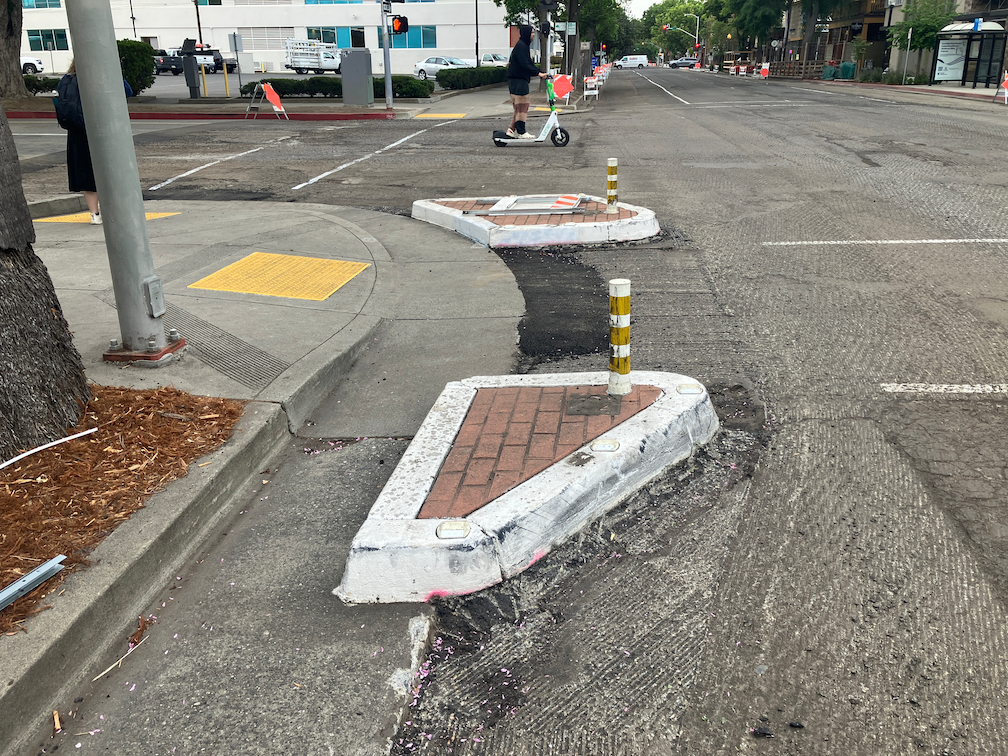
There were several curb islands along 21st Street on the left hand side. All but one have been removed. The remaining one at 21st Street and Capitol Ave may just be an oversight, but if not, it is in the middle of what is expected to be the separated bikeway.
Sac_21st-St-Capitol-Ave-SW_curb-islands
The fourteen blocks of 21st Street from W Street to H Street has been stripped down about two inches, for repaving. The restriping after paving will include the separated bikeway.
The project webpage has a diagram for the transition of a separated bikeway on the left side of 19th Street southbound to the right side of 19th Street south of W Street, which is a two-way street. However, it does not have a diagram for the transition of this 21st Street separated bikeway at the north end, where 21st Street becomes a two-way street at I Street. This is already a hazardous intersection due to the double left-turn lane from 21st Street to I Street westbound.
Separated bikeways are only as safe as their intersection treatments, and the transition from and to separated bikeways to regular bike lanes are critically important. I hope that the city has a good design for 21St Street and H Street, otherwise bicyclists will be placed in more danger than existing conditions. The solution is of course bicycle signal faces that allow bicyclists to move when other traffic is held, but the city has been reluctant to use these.
A bike/scooter corral was installed on R Street in a parking space, next to the Sacramento Natural Foods Co-op. Though for a while drivers respected the set-aside, marked for bikes and scooters, drivers came to use the space as regular parking, with a car parked there almost all day long, preventing the intended use as a bike and scooter parking area. I reported this illegal parking to the city a number of times, but to my knowledge, no one was ever ticketed. It should be noted that parking is not short on the streets around the co-op, and there is a parking garage adjacent to the co-op, which I have never seen full. So drivers were using the spot for personal convenience.
The city recently installed vertical delineators (flex posts) in the spot and repainted the while line that signifies are bike parking area. So far it is working, I’ve not seen anyone run over the posts in order to park there.
The majority of the bike/scooter corrals in the city have been placed on wide sidewalks, where they don’t interfere with walking. The in-street corrals are mostly being respected; this is the only one I am aware of that was routinely violated.
These corrals are designed to solve two issues: 1) provide parking where traditional bike racks are not present or insufficient; and 2) to keep scooters (mostly rental scooters from the scooter-share companies) from filling up the regular bike racks and preventing their use by the public.
Capitol Corridor has received more funds from the TIRCP (Transit and Intercity Rail Capital Program) for some projects in the Sacramento region. It includes full funding of the Sacramento Valley Station transit hub, additional funds for the Sacramento-Roseville third track project, and contactless readers for Thruway buses (presumable the same readers that have been installed on the trains, which will allow direct payment for trips once the Tap2Ride pilot is complete).
I have been using a Twitter connection to announce my blog posts on my Twitter feed (@GetAroundSac). I’ve removed that connection. I’ve added a subscribe button prominently on each page, just below the categories drop-down.
I’ve been a pretty active Twitter user. Though I don’t think of myself as addicted, I certain spend a lot of time there. But a lot of the people I follow have either left Twitter or are using it much less. I notice less and less local (Sacramento region) tweets. Some of the users I follow have taken to retweeting everything they see, which is clogging my Twitter feed with items that I already see, or am not interested in. This may be a desperation move as their own followers drop away. So I’m getting bored with Twitter.
Of course as nearly everyone does, I question whether I should even be on Twitter, that social media platform owned by one of my least favorite people in the world. Some days it seems like Twitter is working OK, but then he makes a nonsensical change that makes everything less useful. His management is pretty clearly oriented towards amplifying right wing voices. I’m guessing he wants to be the first person to accomplish throwing $44 billion in the toilet (that’s what he paid for it, but his own valuation is now $20 billion, and falling).
So, I haven’t left Twitter. Yet. But am thinking about leaving more and more.
This is an update to the update on work being done on corner ADA ramps in the Sacramento central city, apparently as part of the Central City Mobility Project.
So far as I have seen, curb extensions are not part of this project.
There are now a number of locations where the concrete ramp is being cut so that the detectable warning strip can be installed, but the curbs are not being touched. See below for an example.
Q-St & 16th-St, SW corner, ADA ramp construction
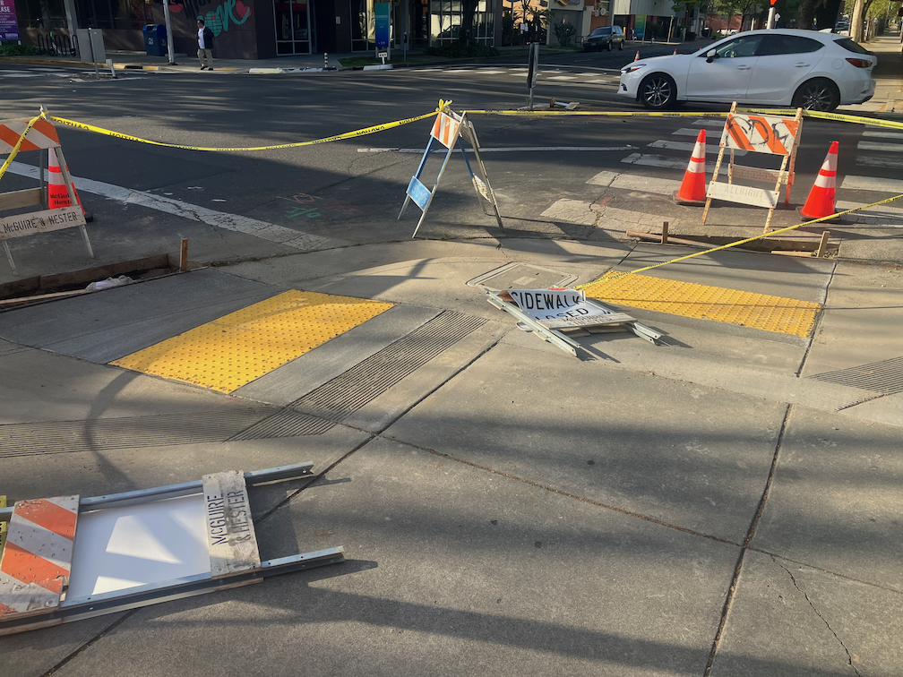
One of the corners I have been monitoring, 21st St and O St northeast corner, is complete, but with temporary patches that make the ramps useable, though ironically still blocked by folding barricades and caution tape, which absolutely does not meet ADA guidelines for contruction signing and safety. This seems to be the pattern with the city, trying to make things better, but not paying attenteion to the details. I don’t know when the asphalt will be restored and the corner opened. Maybe the contractor is waiting until all the corners are ready before patching, though that would be stupid.
21st-St & O-St, NE corner, completed corner with ADA ramps
I am still not able to make sense of the asphalt cuts that are being done on the corners where the curb will be or has been modified. I’m guess that there was a standard cut design, implemented everywhere, no matter what the actual project.
Walking around the central city, it appear that most of the corners which did not have ADA-compliant ramps will have them when the project is done, but some may not. I don’t know what the criteria is for which corners are being done, and which are being done at a higher level of replacing the curbs and widening the ramps. Many of the existing ramps are narrow, with edging curbs, which was apparently the design at the time they were placed, but the new corners are a different design, with a sloping area between the two ramps, similar to the diagram below, from the 2020 Department of Utilities Standard Specifications: Transportation drawings, not from the 2009 Department of Public Works Street Design Standards, which contain no ADA diagrams. I think the detectable warning strip width is at least 60 inches on the new installations, which is an improvement. The 48 inch width does not allow two people to stand on the strip. Corners with new curb extensions seem to have 72 inch strips.
Part of an ongoing series of posts to support better streets in the City of Sacramento during their 2023 update of Street Design Standards. New standards must be innovative, safe, and equitable, and it will take strong citizen involvement and advocacy to make them so.
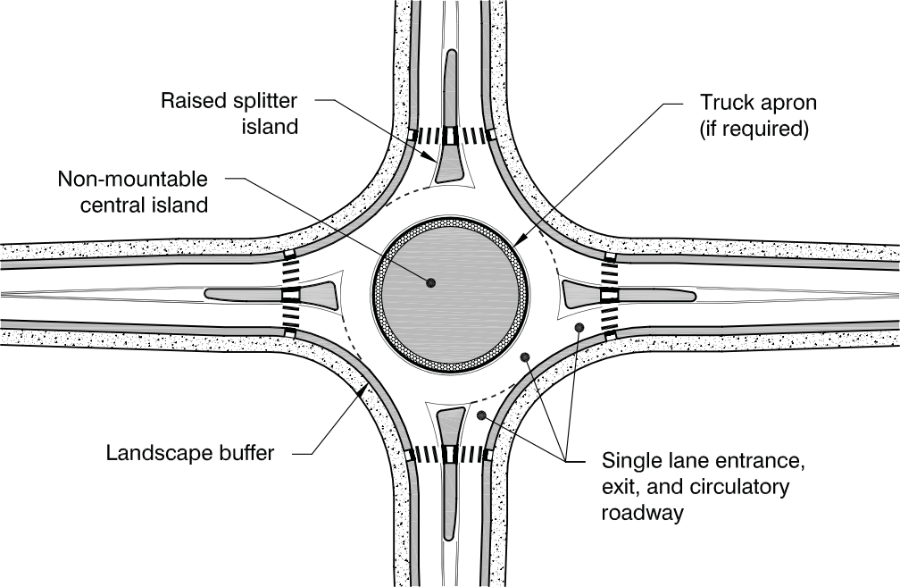
The most important point of intersection design is that multi-lane roundabouts have absolutely no benefit for people walking or bicycling, particularly those with vision or mobility limitations. They are no more safe than regular intersections, and some research indicates they are less safe. They are just more motor vehicle infrastructure masquerading as something innovative and safe. If the city were to include a design for multi-lane roundabout, it would be a travesty.
This is also the last of the design detail posts. I realize that the posts have veered off into related issues, and the piecemeal nature of the posts makes it hard to see the overall pattern, so I will try for a summary post in the near future.
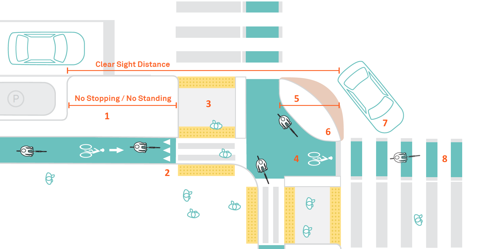
Policy
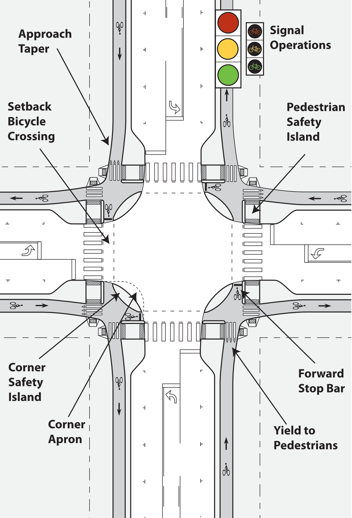
New or reconstructed intersections of neighborhood streets will generally use protected intersection design
New or reconstructed intersections of corridor streets will use prote
New and reconstructed intersections will include curb extensions, raised crosswalks or raised intersections, and/or protected intersection design
ADA ramps at intersections will always be perpendicular to the roadway, never diagonal
Daylighting for visibility will be provided at all intersections, through red curbs, curb extensions, or protected intersections; if red curbs alone are used, the offset from intersection should be at least 15 feet
Roundabouts: single-lane roundabouts will be considered for any reconstructed intersection except local streets; multi-lane roundabouts have no safety benefits and will be prohibited
Intersection corner radii will be set to ensure slow and safe turning speeds for all motor vehicles; truck and bus routes will never be more than 15 feet
Safe crosswalks will be provided at no less than every 1/8 mile in all urbanized areas; 30 mph, crosswalks must have at least pedestrian activated or automated flashing beacons; at 40 mph, crosswalks must have full signalization
Slip lanes will be removed from existing streets and not installed on new or reconstructed streets
Pedestrian crossing prohibitions will be removed from all intersections except those with freeway onramps and off ramps
Design diagrams will include:
ADA ramps, including design which prevents accumulation of water at the base of ramps
intersections of local streets
intersections of neighborhood streets with neighborhood streets or local streets
intersections of corridor streets with corridor streets, neighborhood streets, or local streets
protected intersections
modal filters/traffic diverters
single lane roundabouts
curb extensions (bulb-outs), with concrete curbs
interim curb extensions with paint/post installations
NACTO ‘Don’t Give Up on the Intersection’ Protected Intersections diagramAlta Design+Planning ‘Evolution of the Protected Intersection’ diagramNCHRP ‘Roundabouts: An Informational Guide’ diagram
I have been irritated by the Caltrans ‘Let’s Change This to That’ advertising campaign for litter pickup and highway cleanup. Certainly litter is a water quality issue, particularly when that litter is washed into the ocean. The really big problem is not the litter, however, but the roads and highways that Caltrans has designed. The highways and wide roadways seem especially adept at accumulating litter, and illegal dumping. Could it be that the highways are such horrible places that people feel compelled to litter them? The highways are overbuilt, incredibly expensive, destroyed and divided neighborhoods, inject air pollution straight into low income communities, and prevent real solutions to climate change and livability. Maybe litter is a comment on all this.
Inspired by the campaign graphics (second below is an example), I’ve created one of my own. I took a shortcut, using something that has already happened (without Caltrans cooperation), the Embarcadero Freeway in San Francisco which was damaged beyond repair in the 1989 Loma Prieta earthquake. When I have the time, I’ll look for other photos to pair, of actual changes or of potential changes. I’ve seen AI transformations that I think could play well for that, but a big part of my purpose here is to call out Caltrans greenwashing.
If this idea inspires you, I’d like to see your campaign graphics for highway removal. My ‘Let’s Change This to That’ graphic is available as a webp. Don’t know how to upload other formats.
‘Let’s Change This to That’ for Embarcadero FreewayCaltrans ‘Let’s Change This to That’ graphic
There has been construction on several of the corners I had previously mentioned (half-measure corners?), with 21st Street and O Street being the most advanced. It seems that I was wrong about curb islands being put in – there is no evidence of such construction. I don’t know why the asphalt cutting implied that. When more of these are complete, I’ll post again.
What seems to be going on is simple updates to place ADA-compliant curb ramp with detectable warning strips. Of course any improvement to curb ramps helps everyone, disabled and otherwise, and I’m not criticizing that. Rather, wondering why when the city is changing these corners, they did not take the opportunity to do true curb extensions. The ADA ramp and detectable warning in place for O Street is wider, than previous ramps and strips, looks to be more than four feet rather than the prior narrow ones. If all the ramps end up wider, that will be a plus.
This work is probably part of the city’s Central City Mobility Project. The project detail mentions ‘turn wedges’. Maybe the wedges will be added later, or maybe these will be at different locations than the ones I’ve looked at. The page does not specifically mention ADA ramp improvements.
21st St & O St, northeast corner, ADA ramp construction, partially complete
I had mentioned in the previous post curb extensions being extended to serve as bus boarding areas. I am not aware of any of these in Sacramento, but San Francisco has many. Many earlier posts have mentioned bus boarding islands, but this is for a street without bike lanes (yet), which allows the bus to stop in-lane and people to board directly. Notice that the extension allows for a bus shelter without constraining the sidewalk width for walkers. This should be the standard for Sacramento for all streets with bus routes but not bike lanes.
curb extension and bus boarding extension, San Francisco, Leavenworth & Sutter


