Tomorrow night (Nov. 8) at 6 PM the Sacramento City Council meets to vote to adopt a plan for the Freeport Blvd. Bike Lane project.
City staff propose replacing 4 substandard-width traffic lanes on Freeport Blvd. between 4th Ave and Sutterville Rd with 5 lanes: 2 standard-width traffic lanes and a center turn lane for motor vehicles and bike lanes in both directions (Segment Design Concept 2 on the website below). Staff also proposes bike-friendly modifications to the intersection at Freeport and 4th Ave, in front of Taylor’s Market (Intersection Design Concept 2).
The segment improvements are exactly what bicyclists need for safety, and while the intersection improvement isn’t the best one (see #4), it’s affordable and workable.This is a good plan and it looks likely a council majority is prepared to approve it.We need **100** bicyclists to attend this meeting to show the council that our community supports these kinds of essential safety improvements. If you ride on Freeport or care about the safety of someone who does, please join us and please share this invitation with others!
Questions? Contact SABA at jim@sacbike.org or 916-444-6600.
10th Street northbound at Roosevelt Park, three lanes reduced to two
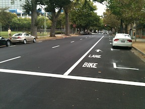
As part of a recent repaving project, now mostly complete, bike lanes were added to several streets in the downtown area, sometimes by converting three travel lanes to two, and sometimes just by narrowing the travel lanes. As an example, 9th Street (one-way southbound) and 10th Street (one-way northbound) were converted from three lanes to two, which freed up space for bike lanes. 10th Street is shown at right. A reduction in the number of travel lanes is sometimes referred to as a road diet. However, the amount of right of way is the same, it has just been shifted to serve all modes of travel more effectively. The reduction in motor vehicle lanes reduces the motor vehicle road capacity slightly, but far less than many people think it will. In fact, with more space for bicycles, more people will bicycle and the motor vehicle traffic drops somewhat, lessening congestion for everyone.
I Street westbound just past 7th St; sharrow in time restricted lane
Sharrows (shared lane markings) were also used liberally throughout, particularly on east-west streets. Along I Street westbound, bike lanes are present in some blocks and sharrows in others. The photo at right shows the sharrows placed within a time restricted travel lane in front of the courthouse on I Street. When parking is allowed, the sharrows form a defacto bike lane adjacent to parked cars. This lane is a bit wider than it was before. During no-parking times, the sharrows define their usual meaning, that “Bikes Can Use Full Lane”. The MUTCD R4-11 sign is used at times to provide the same indication. Sharrows are placed in lanes which are too narrow for a motor vehicle and a bicycle to share side by side, which is less than 14 feet. In any lane narrower than 14 feet, the bicycle not only can be should occupy the middle of the lane to prevent motor vehicles from passing too closely.
Some criticisms of the project:
Sharrows are placed inconsistently within the travel lanes. They should always be centered in the travel lane, but it looks like in some cases they were placed a certain distance out from the curb. Placement too far to the right encourages motor vehicle drivers to try to squeeze by, which is what creates the hazard.
The alternating of bike lanes when there is space with sharrows when there is not space is an understandable effort to create the best solution to a challenging situation, but in my mind, it fails. Regular bicyclists often take the travel lane anyway, in order to create the necessary distance from parking cars and their dooring hazard, to bypass slow traffic, and to prepare for left turns. It is the less confident bicyclists who would benefit most from the new bike lanes, but I think they will be quite confused with the change back and forth between bike lanes and sharrows.
I think that all three lane streets in downtown should be converted to two lanes. Three lane streets encourage high vehicle speeds. It is not unusual during non-congested times to see vehicles going 40 mph on these streets, where the posted speed limit is 25. An opportunity was missed to make these conversions.
I also think that one-way streets should be converted to two-way streets. Again, one-way streets encourage high vehicle speeds, and in fact they are designed to do this, to flush cars in and out of downtown twice a day. They are called traffic sewers for a reason. Two-way streets create an environment where drivers are much less likely to speed. Of course once a street has been road dieted to two travel lanes, a conversion to two-way is much easier.
Despite these criticisms, though, I am pleased to see the new bike lanes freshly painted. I suspect this project has doubled the number of sharrows in Sacramento, and as people see them used more and more, they will become more effective. It was a pleasure riding on Sunday from my residence in midtown south to the farmers marked on 9th Street, and then back north on 10th Street.
Promising a college, project seeks approval (SacBee, 2012-10-12); this is an example of yet more suburban sprawl, far from transit, that will increase driving and trap residents into having to drive everywhere
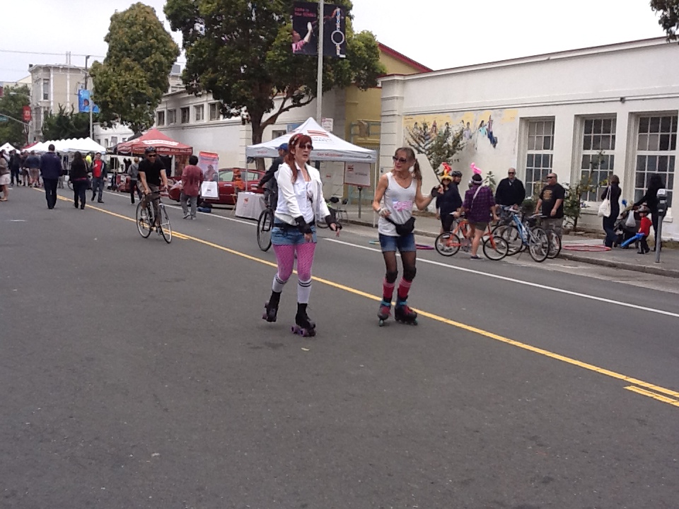
Bicyclists, walkers, skaters, families, bands, food, fun physical activity, welcoming businesses, community organizations, craziness! And no cars. What more could you ask for?
It was my pleasure to find myself in San Francisco on Sunday, July 1, for Sunday Streets. I was in the bay area to visit friends, and just happened to notice on Streetsblog that there was a Sunday Streets event. I’ve heard about these but never participated, and really looked forward to it. At 11AM, not too much was happening, a few people wandering and many people setting up, but by 1PM, that place was hopping, with so many people that it was sometimes difficult to keep moving. But that isn’t a bad thing. The 11 blocks of Valencia Street and 12 blocks of 24th Street in the Mission District of San Francisco (south of downtown) were blocked off to car traffic, though some cross-streets were open to cars.
The California Senate joined the Assembly in passing SB 1029, which funds the first part of the California High Speed Rail system (see SacBee: California high-speed rail gets green light), using both state bond issue and federal transportation funds. The high speed part will be the Madera to Bakersfield section in the central valley (or just short of those end points), and there will be improvements not as clearly defined to the bay area and southern California rail networks, and may include electrification of Caltrain on the bay area peninsula. Of course all Republicans were opposed. I assume they just don’t like public money spent on things that don’t have to do with cars, their favorite welfare recipient. They claim that there isn’t money for it, but there seems to be money for highways.
It will be a long while before the system is done, and service to Sacramento is presumably at the tail end of the system. It may not ever be completed with the original vision, but I do think it will be completed, and will be one of the best things California has ever done for itself.
The central valley focus does not make many people happy, but the federal government essentially forced this on the state, saying they wouldn’t provide money if it didn’t start there. I don’t really understand their reasoning, but so be it. I also have concerns about where the line will go from Bakersfield. The rail authority has designated a route through Palmdale, even though no one wants to go to Palmdale, which is longer in both miles and time than a route over or under the Grapevine. On the northern end, the selected route goes through Pacheco Pass to pick up San Jose, which is at least more logical, but then faces the NIMBY towns on the peninsula to get to San Francisco. Another route across Altamont Pass was rejected but may not be completely dead – there is now a branch line over Altamont, the same route as the current Altamont Commuter Express (ACE), to serve Sacramento. Just to think outside the box, I actually think that a route directly across the bay bridge and into San Francisco might be the best. What are all those people doing driving across the bridge when they could be using public transportation? BART goes under the bay, why not additional options over the bay, on the bay bridge. Giving up a lane or two to rail traffic would be of benefit to all.
The City of Sacramento will include on the November ballot a repeal of Measure A, from 1977, which prohibits the city from requiring green waste bins. If passed, the city has already established a policy that “the claw” would only be used during three months, November through January, and during other months, green waste bins would be required for everyone.
Why is this a transportation issue? The yard waste ends up most commonly in the bike lanes. Piles of leaves can be challenging, but branches end up in the piles as well, an almost certain guarantee of a bicycle crash. At night the dark piles don’t stand out, and I’ve hit a number of them. Once the pile is there on the street, it accumulates all sorts of other trash as well. Some jerks seem to take it as an open invitation to add household trash, and couches, and … The piles could be placed in the parking lane, but almost never are. On streets without bike lanes, the piles constitute a mine field for the bicyclist who rides close to the right. Of course one can avoid the piles by taking the travel lane, as I and many others do, but at least as many bicyclists won’t place themselves there and end up swerving back and forth to avoid the piles.
If the measure passes, we will still have three months of piles, but there should be fewer of them as many people use the green waste bins year round. In my experience, the fall is the most challenging time of year, as the abundant leaves are hit by the fall rains and decay into a slimy slippery mess. I love that Sacramento has so many trees, and therefore so many leaves, but it is still a challenge.
We’ve all experienced waste bins in the bike lanes as well, trash, recycling, and green waste. But this seems a more manageable issue to me, as the owners can be cited and the bins moved by cyclists. In my opinion, bins belong in the parking lane where one is present, and where not, in the owner’s driveway or yard. Unfortunately, law does not seem clear on this point.
Bins do not ever belong on the sidewalk. As much as I am inconvenienced by bins in the bike lane, I never want to see them on the sidewalk, where they completely block access by disabled people and make walking less pleasant for everyone. When I’m walking, I always move bins off the sidewalk and back into people’s yards or driveways. Fortunately this is not a major problem in the city of Sacramento, but is common practice in the suburbs and other cities of the region.
A Better Shop Class, Bicycle Times, Volume 017, May 2012 (not available online, you must look at the print or iPad edition): a short article about the bike repair program at Met Sacramento, a local high school
News seems light this period, which may be a good thing. So far as I can determine, no pedestrians or bicyclists were killed, or injured badly enough for it to show up in the Sacramento Bee. The search page I look at is http://blogs.sacbee.com/crime/archives/type-of-crime/traffic-accidents/.