- Raley’s announces plans for new store at old Hubacher Cadillac site (Sacramento Business Journal 2015-08-27); Raley’s to build supermarket at longtime Arden auto dealership site (SacBee 2015-08-27)
- NIMBY: Another View: Central Sacramento has enough low-income housing (SacBee 2015-08-27)
- Sacramento launches 10,000-unit downtown housing initiative (SacBee 2015-08-26)
- Transit advocates, riders celebrate light rail south line opening (SacBee 2015-08-24)
- Filling in the gaps on Stockton Boulevard (SacBee 2015-08-24)
linking the colleges?
I attended the Blue Line extension to Cosumnes River College (CRC) Grand Opening this morning at Meadowview station and then at CRC station. It was a lot of fun. There were more politicians in one place that I think I’ve seen, and they were justifiably proud of their part in supporting this extension, some having worked on it for years. [Photos on Flickr]
A number of speakers talked about linking the colleges, in this case Sacramento City College and Cosumnes River College. An increasing number of students apparently take classes at more than one campus in order to get the ones they need, so this extension is expected to help them, whether they don’t have a car or just choose to get around in a more convenient and more responsible way. Folsom Lake College’s Rancho Cordova Center is very close to the Mather/Mills light rail station. The Cosumnes River College’s Elk Grove Center will be on light rail if the Blue Line is extended to Elk Grove (Blue Line Phase 3). American River College’s Natomas Center will be on light rail if the Green Line is extended to Natomas. All of these connections are great, for students and for the community.
Unfortunately, American River College’s (ARC) main campus in North Highlands was barely mentioned. Brian King, Chancellor of Los Rios Community College District, said that ARC was served by a robust bus system. Unfortunately, that is not true. ARC is served by Route 1 (Greenback) on a 15 minutes frequency, and Route 82 (Howe-65th) on a 30 minute frequency, which is hardly robust service. Route 82 only runs until 9:30PM, missing students with later classes or who are staying to study, and who need to make connections to other buses or light rail to get back home.
News summary 2015-08-23
- Sacramento’s opportunity to improve cycling (SacBee 2015-08-22)
- Here’s the latest financing idea for a streetcar from downtown to West Sacramento (SacBee 2015-08-21)
- Sacramento’s light-rail extension opens Monday with big questions (SacBee 2015-08-21)
- Five things to know about Sacramento’s new downtown housing initiative (Sacramento Business Journal 2015-08-21)
- How the ‘Fix My Ride 916’ social media campaign could be a major step for Sacramento 3.0 (Sacramento Business Journal 2015-08-21)
- Editorials: RT riders get a louder say (SacBee 2015-08-20)
- Study: Sacramento region continues outward growth despite ‘Blueprint’ goals (SacBee 2015-08-20); Editorials: Region Blueprint isn’t a failure (SacBee 2015-08-21)
- Years in the works, RT’s Blue Line is nearly ready to start service (Sacramento Business Journal 2015-08-18)
- Sacramento sports teams try to ‘fix’ transit ahead of downtown arena opening (SacBee 2015-08-18)
- Is Sacramento Light Rail Safe? (SacBee 2015-08-17)
- Backseat Driver: Sacramento’s central city residents want parking rights protected (SacBee 2015-08-17)
- Local train stations … through a photographer’s eyes (slideshow) (Sacramento Business Journal 2015-08-17)
parking rights?
Tony Bizjak wrote in his Back-Seat Driver weekly column yesterday about parking issues in the central city, Backseat Driver: Sacramento’s central city residents want parking rights protected (SacBee 2015-08-17), as a follow-on to the community meeting held by Steve Hansen last week.
I don’t know whether Tony was responsible for the headline, but the headline does at least accurately reflect the view of some central city residents that they have a right to free parking, right in front of their house, and of some suburban commuters that they have a right to low cost parking right at their place of employment. There is no right to parking. You won’t find it in the constitution, federal, state or local law, nor in the bible, protestations to the contrary. There are always trade-offs in providing parking, including reduced livability, air pollution and carbon release, potentially lower walkability and bikeability, a less effective transit system, proliferation of that most ugly of urban forms – the parking garage and the surface parking lot, and most of all, encouragement to drive everywhere – a relict of the 1950s and 1970s that most “world class” cities are rapidly moving away from.
The article opens with “A downtown can’t prosper if its people can’t park their cars,” which has become a tag line for comments at the SacBee, Facebook and Twitter. Says who? The implication is that all other considerations are subservient to the demand for parking. A city’s businesses can’t prosper if customers can’t find parking reasonable close to the business they wish to frequent, for those customers that must or choose to drive. All day commuter parking and all day and night residential parking are in fact what threaten the prosperity of downtown, and it is our existing parking policies that make this so. A downtown can’t prosper if it is not walkable, bikeable and transit friendly, and in my opinion those are at least as important as drivability. It is not that parking need necessarily conflict with these other goals, but it does currently, and the restrictions, requirements and limitations being asked by some residents and some commuters will make it worse, much worse.
Hansen’s community meeting on parking

On August 12, Steve Hansen sponsored a community meeting on parking issues. This is a report and reaction. The meeting was actually quite civil, not often the case when neighborhood people get involved in issues. There was clapping for things they liked but no booing and no angry outbursts.
Matt Eierman, parking manager for the City of Sacramento, presented on the current proposals and a bit about future ideas, what the city is calling “parking modernization.” He addressed concern that there would not be enough parking for the arena by showing a map of downtown parking spaces overlaid with walking distance at the Sleep Train Arena (ARCO), with sufficient parking available.
Eierman claimed that credit card fees at parking meters cannot legally be charged back to the credit card holder, however, San Francisco and many cities outside California are doing just that.
Eierman said dismissively that he hates the idea of “dynamic” parking fees, the idea that parking rates would change with location, time of day or day of week. He said “no wants to drive up to a meter and not know how much it is going to cost.” This is an absurd statement, and I’ll provide an analogy. Would a person say they are never going to buy apples at the store again because they don’t know ahead of time whether they are $0.89 or $1.19 this week? Of course not, people make decisions based on changing information, and parking is no different. With a smart phone, the person would know the fee even before pulling into the space.
The two things being proposed to go the the city council in the near future are:
- An increase in the parking rate from $1.25 per hour to $1.75 per hour, at all on-street metered parking in the central city. The city pointed out that fees have not increased in some time, though costs have gone up, and that an increase for on-street parking would shift longer term parking off the streets and to city parking garages and lots, some of which are very underutilized.
- A SPOTZone (Special Parking Over Time) pilot in Old Sacramento and one location in midtown that would allow people to pay for time beyond the set time limit, at a higher price. The pricing would discourage long term parking, causing more spaces to be open, but through payment mechanisms (smart meters and smart phone payment) would reduce the number of parking citations.
transit frequency in Houston and Sacramento
Houston has been in the news recently, and will certainly be today, opening day, for their revised transit system which created a network of high frequency (service every 15 minutes or better, 15 hours a day, 7 days a week) transit lines. The map below left shows this new system, only, and clicking goes to the high resolution image on the Houston METRO website. The map below right shows the entire system, with lines that don’t meet the high frequency definition. The system was redesigned with the help of Jarrett Walker, transit consultant and author of Human Transit, which I posted on yesterday and will be posting a lot more in the near future.


So, what’s the story in Sacramento?
Beg buttons on K? Really?
Note: I discovered yesterday, to my chagrin, that I had a number of draft posts dating back to early 2013, which I’d never finished. So I’m going to post them now, all in a flurry. Some of these issues I’ll get back to and do an in-depth and up-to-date post, and some of them I probably never will. This is the fifth and last post, and I discarded two that were worth preserving. This just points out that I have more good ideas than I have time to carry them out.
My point here was that beg buttons should not be used on streets which are meant to encourage or emphasize walkability, of which K Street is certainly one. I will definitely be writing more about this.
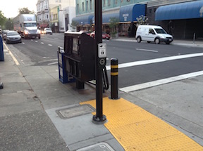
Original 2015-04-11: I have to admit that sometimes I walk past things every day and don’t notice them, but this morning I noticed the pedestrian activated buttons on K Street in downtown Sacramento. Yes, they’ve probably been here since the street was re-opened to cars on November 12, 2011. These are technically called pedestrian pushbuttons, and their purpose is to activate the pedestrian signal head and a change of the traffic signal. They are often called beg buttons, because the pedestrian has to “beg” to cross the street by pushing the button, rather than being an accepted part of transportation on the street.
Sacramento in the middle for transit loss
Note: I discovered yesterday, to my chagrin, that I had a number of draft posts dating back to early 2013, which I’d never finished. So I’m going to post them now, all in a flurry. Some of these issues I’ll get back to and do an in-depth and up-to-date post, and some of them I probably never will.
Original 2015-06-10: The recent CityLab article How Much Money U.S. Transit Systems Lose Per Trip, in 1 Chart shows Sacramento RT in the middle, a common place for Sacramento to be.

Rangelands and greenfield development
Note: I discovered yesterday, to my chagrin, that I had a number of draft posts dating back to early 2013, which I’d never finished. So I’m going to post them now, all in a flurry. Some of these issues I’ll get back to and do an in-depth and up-to-date post, and some of them I probably never will.
The topic was going to be greenfield development in Sacramento County, Rancho Cordova, Elk Grove, and Roseville, and how it will be impossible to achieve greenhouse gas reduction targets if the governments allow this type of sprawl or super-sprawl development to occur.
Original 2014-12-29:
Lost California rangeland is said to pose greenhouse gas risk (SacBee 2014-12-28)
New Study: Where Have All The Rangelands Gone? (The Nature Conservancy 2014-10-23)
Whither the Rangeland?: Protection and Conversion in California’s Rangeland Ecosystems (PLOS ONE 2014-08-20)
move to West Sac?
Note: I discovered yesterday, to my chagrin, that I had a number of draft posts dating back to early 2013, which I’d never finished. So I’m going to post them now, all in a flurry. Some of these issues I’ll get back to and do an in-depth and up-to-date post, and some of them I probably never will.
I wish I knew where these quotes came from. It was something I was reading. The point was that a number of people had commented recently that things were going backward on the east side of the river, livability-wise, and things were going forward on the west side of the river, mostly due to Mayor Christopher Cabaldon. Some connection was made between this topic and these quotes.
Original 2013-09-10: “You could build all bridges and highways that you wanted to, and you still got more congestion. You could add all the bike lanes and bus service that you wanted, and you still got more congestion and worse air. Because it was the land pattern underneath.”
“It doesn’t matter if you have great bike paths and sidewalks and bus lanes if everybody is living so far apart from each other that they can’t get connected. And if you just build more, wider freeways, with the same land use pattern that we have…keep growing more and more into farm land and habitat…then people just fill up those freeways faster and faster and faster.”

