Protected Intersections

When I posted on the North 12th Street Complete Street Project, I expressed concern about how the  cycle track to the north would transition to the bike lane to the south, and how bicyclists northbound would access the cycle track. On Wednesday I attended the project open house at City Hall. Preliminary designs presented by the contractor Echelon Transportation Group indicate one possible design for the intersection of 12th Street and C Street, a protected intersection. These conceptual design drawings are not yet available on the North 12th website, so I don’t have a drawing to share here. Comments from the open house and online will be used to revise the concepts, and they should then be available on the website for further review and comment.

The protected intersection is a design new to the United States, and so far not built anywhere in its entirety. The design is fairly common in bicycling friendly countries in Europe. The Protected Intersections for Bicyclists website provides a great video showing how the design works by providing a higher level of safety for bicyclists and pedestrians without much impact on motor vehicles. The design has not yet been included in the NACTO Urban Bikeway Design Guide, but I would guess it soon will be.

protected intersection

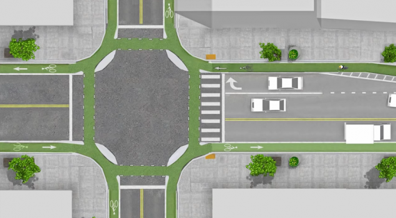
The diagram at right shows the general outline of a protected intersection. The intersection at 12th and C would look like the right half of the diagram on the west side, with the almond shaped corner medians, but would not look like the left half on the east side. Bicyclists heading south out of the cycle track would either continue south in the bike lane or use the protected intersection to turn east and then continue south on lower traffic streets. Bicyclists coming from the east would use the protected intersection to get to the west side and the cycle track.

News summary December 21

Carnage

Other

South Sacramento Vision Zero

Vision Zero Kick-Off MeetingWALKSacramento and other partners are hosting a Vision Zero Kick-Off Meeting on Wednesday, January 14 in south Sacramento, part of the ongoing Building Healthy Communities project. This is the first event in Sacramento, and I encourage you to participate, even if you don’t reside or work in south Sacramento. A city, county and region can be judged by how it treats its most vulnerable citizens, and there is no doubt that walking (and bicycling) safely is a major justice challenge for south Sacramento. Click on the thumbnail at right to view the flier.

From WALKSacramento’s email:

You are invited to join WALKSacramento on January 14, 2015 as we launch “Vision Zero” in South Sacramento.
Vision Zero aims to reduce pedestrian and bicycle fatalities to ZERO by improving infrastructure, education, and enforcement.  We’re starting a Vision Zero project in South Sacramento because we know that it is within our power to prevent these tragedies on our streets.
We need better street design, better regulations, and better enforcement.
Let’s start talking about what we can do to help make Sacramento streets safer.
For more information and to RSVP, please contact Emily Alice Gerhart, egerhart@walksacramento.org

Vision Zero, which started in Sweden, is now a wordwide effort to eliminate pedestrian, bicyclist and motor vehicle fatalities. In the United States, New York and San Francisco are leaders, but the idea is now being talked about nearly everywhere, including Sacramento.

A Vision Zero for Cities Symposium was held in November in New York City, with attendance by a few people from the Sacramento region. Transportation Alternatives has posted the Collectively Drafted Statement of Principles from that symposium, and Streetsblog USA has a good summary of the event at What Would a National Vision Zero Movement Look Like?

News summary December 14

Crash, crash, crash

NotAnAccidentI don’t know whether the term accident has a new-found popularity, or whether I’m just more sensitive to it the last week, but it seems like everywhere I look in the news media, there it is, the term accident. I’m talking here about use for motor vehicles, bicycles, and pedestrians.

The term accident implies that no one was at fault, it just happened, an act of nature. But nothing that occurs on the roadways is an accident. Someone caused it, or someone contributed to it.

#NotAnAccident (yes, I realize that this twitter tag gets used for other things, but I haven’t thought of a better one)

I have been using the term crash in place of accident for several years. However, several people have commented that crash may be more appropriate to a single user situation, as in, the car crashed into a tree, or the bicyclist crashed on slippery pavement. The word collision implies two or more users, as in, a collision between a motor vehicle and a bicycle or pedestrian. But I’m not yet entirely happy with those definitions either. Incident has also been suggested, but that seems to clinical to me, almost a valueless opposite of accident.

Here are some links:

News summary December 7

Carnage

Other

News summary November 30

Carnage

Other

One-way streets, again

I’m glad to see the idea of converting one-way streets to two-way streets to improve livability and safety is back in the news: More than one way (Sacramento News & Review 2014-11-27).

The reasons given, by Chris Morfas, William Burg, Jim Brown, Dave Saalsaa, and Emily Baime Michaels are all good, strong reasons for conversion.

The comments by Sparky Harris are a little disingenuous. The city already has a plan to convert one-way to two-way, documented in the 2006 Central City Two-Way Conversion Study Final Environmental Impact Statement (no long available on the city’s website, but I have a copy of this large document if you want it). It is interesting that it is not longer on the website. Eight years ago the changes in driving and living habit were starting to become obvious, and even at that time, it was clear that there were considerable benefits from conversion. Except for a very few streets that were converted when they were resurfaced, nothing has been done. Now another study? I’d rather see more action and less study. Yes, some conversions will not have benefits that are as strong, and some will be controversial, but converting many of the streets is “low-hanging” fruit, something that should already be underway and not awaiting more study.

I’ve written about this idea in several posts:

Active Transportation Program (ATP) in region

This is not fresh news, but I just realized that I had not posted about grants in the Sacramento region under the Active Transportation Program cycle 1 awards in 2014.

Regional grants from the statewide program:

  • PLA, Roseville, Downtown Roseville Class 1 Trails, $2,547K
  • SAC, Elk Grove, Lower Laguna Creek Open Space Preserve Trail, $1,778K
  • SAC, Sacramento County, Howe Ave Sidewalk Infill and Bike Lane Improvements, $1,853K
  • SAC, San Juan USD, SRTS, $250K
  • YOL, Davis, SRTS Program, $562K
  • YOL, Woodland, 2014 SRTS, $539K
  • YUB, Marysville, SRTS Project & Programs, $489K

SACOG region grants:

  • ELD, El Dorado County Transportation Commission, Western Slope Bicycle Travel Opportunities Map $50K
  • PLA, City of Auburn, Nevada Street Pedestrian & Bicycle Facilities $799K
  • PLA, City of Colfax, North Main Street Bike Route Project $264K
  • SAC, City of Galt, South Galt Safe Routes to Schools $1,800K
  • SAC, City of Rancho Cordova, Mather Rails to Trails Project $2,235K
  • SAC, Sacramento County, El Camino Avenue Phase 2 – Street and Sidewalk Improvements $1,692K
  • SAC, City of Folsom, Oak Parkway Trail Undercrossing and Johnny Cash Trail Connection Project $992K
  • SUT, City of Yuba City, Franklin Road Improvements $313K
  • YOL, City of West Sacramento, Citywide Bike Lane Gap Closures $525K
  • YUB, Yuba County, Ella Elementary School Safe Routes to School Project $1,195K

There are also three projects on the SACOG contingency list.

Liestal Row shared space

Edible Pedal in Liestal Row

Shared space is a type of roadway that is common in Europe, found in a few places in the United States, and so far as I know, only one place in Sacramento. The concept is that pedestrians, bicyclist, and motor vehicles can mix without having to have set-aside areas defined by curbs and painted bike lanes.

In Sacramento, Liestal Row, an alley between L Street and Capitol Avenue, and 17th Street and 18th Street, is the example. The alley was reconstructed with sidewalk areas defined by smooth concrete and roadway areas defined by bricks, however, there are no curbs in between and no limitations that keep the modes separate. The two businesses in the alley, Edible Pedal and Old Soul, spill out into the alley, and people often stand around in conversation. Often vehicles (including bicycles) have to thread their way between other users. What makes the alley work is that motor vehicle drivers are moving at a very slow speed, and do not have priority over other users. I’ve seen the uncertainty in the eyes of drivers negotiating the space, and that is exactly what makes it safe for everyone, the uncertainty that leads to paying attention instead of making assumptions or driving distracted.

Read More »