Yet another map that may help with understanding the service changes (cuts) proposed by SacRT.
I attended the SacRT board meeting last evening, where there was a presentation by staff on the service changes (agenda item 13), some public comment, and some questions from the board. The gist of the comments and questions seems to be “don’t cut my route,” which is understandable, but doesn’t really advance the discussion much. Mike Barnbaum had the most interesting comments, as he had some innovative ideas for redesigning routes. I briefly presented my design ideas explicated in a previous post (SacRT service changes), and commented that, for the public, the selection of service changes is too much of a black box, input necessary savings, turn the crank, and get out service changes. General Manager Mike Wiley suggested a lot of complex analysis goes into the proposals, addressing in particular questions that were asked by the board about destinations and attractors, however, it isn’t apparent to the public what the criteria are and how they are weighted. Anyway, on with the map.
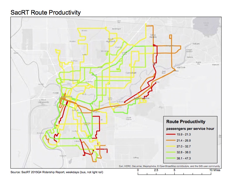
The map (pdf SacRT_productivity-R2)shows all bus routes for which ridership data is available from the SacRT Monthly Performance Reports page. I selected the last available report, fourth quarter 2015, for weekdays. The variable mapped is “passengers per service hour” which is one of the metrics used to measure productivity, and therefore make decisions about routes, but it is certainly not the only metric. The SacRT minimum goal is 27 passengers, so that is one of the break points, with red and orange routes below that level. Only bus routes are mapped, not light rail, because I am not sure if light rail numbers are directly comparable to bus routes. They are certainly much higher, at least for Blue and Gold, as the trains have a much higher capacity than buses.
I realize that all these maps I’m creating would be more useful if presented all together, in an interface that allows the user to turn them on and off, looking at different combinations. That is a part of ArcGIS that I don’t know yet, so there is perhaps my next learning opportunity.
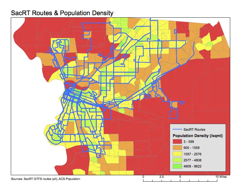
Investigating the proposed SacRT service changes (cuts), I identified that routes serving low density areas are a problem. I developed the map below (pdf SacRT_pop-density) showing routes and population density, with low density areas shown in red. Two routes stand out as servicing primarily low density areas, which are unlikely to ever be productive in a ridership sense. In fact, one of the reasons SacRT struggles to provide efficient transit service is the low-density nature of the county. Though of course agricultural areas north and south of the urbanized area will be low density, there are also large areas of low-density suburb and exurb (sprawl) which will never be successful. Every greenfield development allowed by the county and cities just exacerbates this problem
The population data is from the American Community Survey (ACS) 2014 5-year estimate (S1903), selected by census tract and matched to census tract outlines provided by SACOG, showing residents per square mile. The routes are from the Google Transit Feed Specification (GTFS) provided by SacRT. All routes are shown, including commute hours, low frequency, moderate frequency, and high frequency routes, as well as routes operated by SacRT under contract with others. It would be more useful to identify and/or separate out different kinds of routes, but it takes a while to compile that data, and I’m not quite there yet.
Sacramento Regional Transit (SacRT) has proposed service changes, primarily elimination of routes, most of which would go into effect January 2017, with a few before that and more after than. The proposal is available (summary chart after the jump), and a more detailed analysis is in the Board of Directors agenda (Item 13) for the May 23 meeting. At the May 23 board meeting, the service changes will be an informational item, not a decision. Five open houses on the service changes were scheduled, two of which have occurred, with three yet to go. I attended the open house at SacRT headquarters on May 17.
I was asked for my thoughts on the service changes. Below is a bullet summary, followed by the nerdy details.
SacRT should make the boardings dot map available to the public. It is the best information I’ve seen to indicate which routes are productive, and which not, more understandable to the public than the tables of numbers in the proposal. Additionally, all maps showing routes, including of course the system map, should have an indication of the service frequency, either by color or weight. The “all routes looking the same” maps that SacRT currently uses do not communicate this critical piece of information.
A portion of savings from elimination or combination of routes should be reinvested in other routes which could be moved from acceptable productivity to higher productivity with frequency, service hours, or routing improvements.
Reductions in frequency are counter-productive, usually making a route with challenges into a failing route, which will then be identified in a future round of service changes for elimination.
Routes serving low density residential and semi-rural areas should be cut before routes serving moderate to high density residential areas.
Combining routes for more efficient coverage, particularly where routes overlap or are very closely parallel, is a good idea.
Saturday service should be retained on all routes. Transit-dependent riders who work the usual weekday work week must have service on at last one weekend day so that they can grocery shop, visit friends and family with less mobility, and seek medical care.
Routes should not be eliminated for at least two years after creation or significant revision. Time is needed to see ridership trends once people in a community adjust to the service. Specifically, this means: do not eliminate Route 65 Franklin South.
The concept that routes should focus on light rail connections rather than radial routes to downtown, or point-to-point routes, should be considered in all route decisions.
SacRT should do a complete system re-visioning within the next four years. A series of cuts, and even transit renewal, has left a system that is inefficient and probably unjust. It should be redesigned from scratch.
Total travel time matters, not just in-vehicle time: Not sure how the Green Line measures up, but it is indicative that the Green Line to Township 9 (the current destination) runs on an infrequent schedule (60 minutes) during a small part of the day, because it is beyond the area where most people travel. The airport would also be beyond where most people travel, so is likely to have infrequent and short hours service.
Combine air travelers and airport employees on the same train/bus: The Green Line might do OK on this, though light rail already suffers from the perception of higher income people (which is mostly who flies rather than takes the bus or train) that light rail is only for poor people.
Connect the airport to lots of places, not just downtown, by providing a total network: Since the SacRT network fails pretty badly on connectivity already, it is likely that the Green Line will suffer from the same issue.
Don’t interfere with the growth of other services: The Green Line is definitely a negative on this issue. The Green Line to the Airport would gobble up all the construction funds for years, as well as a large slice of operating funds. Fare recovery on the network is 23%, somewhat below average, but the extension would likely reduce this significantly. If distance-based fares (which SacRT has talked about but done no real planning towards) are implemented on the light rail system, the operating subsidy might be less, but it will still compare poorly with the rest of the system.
If you can afford it, go via the airport instead of terminating there: Not applicable to the Green Line because there is nothing beyond the airport except agricultural fields, and a bit further out, sprawling suburbs that would never generate ridership.
I think the right solution for airport access is frequent bus service (15 minute frequency) from downtown to the airport, from 5:00AM to 12:00 midnight, for travelers and airport employees, and less frequent service from midnight to 5:00AM, for employees. The current Yolobus 42A/42B provides infrequent (60 minute) service from 5:30AM (6:30AM on weekends) to 10:00PM. In addition, there would need to be service from eastern Sacramento/Roseville, but I’ve thought less about how that would work.
Save our infrastructure funds for more productive routes!
I have been using the RideSacRT app for a bit of time, and have some initial impressions.
When I started, I could not get the app to accept credit cards, which is the only way to pay for tickets. It rejected three different cards (two credit and one debit). I asked about that via Twitter, and SacRT responded that they were aware of problems with some credit cards. After a couple of days, I tried again, and my main card was accepted.
It is fairly easy to purchase tickets. Tap on the the “buy tickets” icon on the lower left, select the length (single or daily pass) and type (basic or discount), and the quantity, and then “add to cart.” Then select select your card, or enter your card if you have not used it before, and then “pay now” and “purchase.” You can then use your ticket immediately, or later by selecting “ticket manager” from the pull-up menu in the lower right corner.
The ticket, once selected for use, lasts for 90 minutes and is good on buses and light rail.
William Burg and others have been discussing whether this 90 minute window offered to smart phone users is fair to people who pay cash, and only get one ride. If there were ticket machines available everywhere, it might be reasonable to require that someone pre-purchase a ticket of some sort, but there are not machines everywhere. People paying cash do slow down boarding of buses, often fumbling for the right change and search for money in various places. This is significant because dwell time, the amount of time a bus spends stopped, the largest determinant of how efficient the route is. This is why transit agencies are experimenting with smart phone apps and transit cards like the Connected Card, coming to SacRT some time this century. I’m not sure how I feel about the equity issue.
The app cannot purchase or store passes. The app is a six month pilot, so it is possible that other capabilities will be added during or at the end of the pilot.
The app also offers routing. It opens with a display of a Google Maps centered on the current location, and start/end fields at the top. But the search routine is seriously flawed. It cannot find street intersections. For example, a search for Folsom and 65th St came up with a location far south on 65th St. It cannot find transit stops unless you know and can enter the exact name of the stop. For example, a search for 65th St Station produces nothing, since the actual name of that station University/65th St. If you type a partial match, a list of suggestions is provided, but that list cannot be scrolled, it pops back to the first two on the list and anything further down (which is likely since the matching is so poor) cannot be selected. For example, type “65th” and see what happens. The app is perfectly happy to match partial names to places completely outside the SacRT service area. For example, Berkeley.
So, my first take is that the ticket purchase is worthwhile, but the routing function is worthless.
Note: I’ve not offered a screenshot of an active ticket because I’m not in Sacramento at the moment, and it would waste a ticket to use one.
I attended the open house meeting hosted by SacRT and it’s consultants this evening at the Sacramento Central Library, as did about 60 others. I’ve written before about the green line extension (the green line currently ends at Township 9 on Richardson), so I’ll just add a few comments now, on the bridge, multi-modal transit trips, the airport, and the EIR.
Bridge: The bridge over the American River, between Township 9 and Truxel Blvd, is a key issue. Will it be multi-modal, for light rail, pedestrians and bicyclists, or will it be all-modes, including private motor vehicles? There are good arguments for both. A multi-modal bridge would send a message that we value these transport modes more highly than motor vehicles, and it would be a great deal less expensive. On the other hand, Sacramento is somewhat isolated by the paucity of bridges over both rivers, and this might be a chance to disperse traffic to a new route. However, more lanes generally induce more traffic, and become congested, and lead to higher GHG emissions that both work against climate mitigation and undo the other good things we are doing. The planning does not seem to be far enough along to have any cost estimates for the bridge alternatives. The consultant at the bridge display was a fill-in, not the bridge engineer, so it wasn’t possible tonight to get any more detailed information. The recently completed rail-ped-bicycle bridge over the Willamette River in Oregon did not include motor vehicle traffic in part because it would have greatly increased the cost of the bridge. I suspect that both the city and SacRT will claim that the all-modes bridge is not significantly more expensive, but this claim needs to be watched closely and perhaps challenged.
Multi-modal transit trips and bicycles: SacRT just does not seem to get that almost all transit trips are multi-modal, as they include walking and bicycling at one or both ends of the trip. There was no mention at any of the displays of providing on-demand bicycle storage at stations, and discussions with several SacRT staff indicated that it wasn’t something they were even thinking of. The center platforms (boarding in the middle, tracks on the outside) to be used in several locations won’t even allow space for bike storage of any sort. I believe the only thing that will get North Natomas commuters out of their cars is if they can ride their bike to and from the station (there are some great paths, and some of the arterials are not horrible), leaving it there for the day because they don’t need it at the downtown or Folsom end where they work. The failure of SacRT to provide on-demand, secure bicycle storage has been raised by myself and many others for years, but still nothing has happened. The on-demand BikeLink lockers and station on the Folsom line were purchased and are managed by the City of Folsom, not by SacRT. I will suggest that a light rail line to North Natomas will fail if on-demand bicycle storage is not provided. SacRT only needs to visit the bay area systems to see that no one is any longer building or revising stations, or providing or updating rail cars, without serious provision for bicyclists.
Airport: Why does light rail need to go to the airport? I’m not sure that anyone has a financially sound reason for it. The line would go through miles of empty farm and ranch land. Will this land eventually be developed? Perhaps, but not likely. The GHG implications of this type of sprawl development will at some point stop it in its tracks, and at least some of the agricultural land will remain as such. Sure, cities like to be able to say they have transit to the airport, but in two places I visit where light rail does go to the airport, Portland and Seattle (both high-transit use locations), most people still drive to and from the airport. Both lines have large numbers of intermediate stations that serve many users beside airport customers, but the green line would not. In a less transit-oriented place like Sacramento, how many people will use the airport extension? And at what cost per passenger? If we had unlimited funds, I’d be all for an airport extension, but we don’t have unlimited funds, and an extension to the airport greatly delays, or perhaps kills, extensions to ARC, Roseville, Elk Grove and Davis.
EIR: The environmental impact report will have to cover the entire extension to the airport, because projects cannot be considered piecemeal, but there is a danger that ONLY the entire project will be analyzed, and that the segments will not also be analyzed separately. As I’ve said before, I think there is a clear justification for the extension to South Natomas (stopping south of I-80), there may be justification for segment to North Natomas, if the system can be designed in such a way that it will actually be used by the car-centric residents of North Natomas, and there is little justification for the segment to the airport. If the segments are analyzed separately in addition to as-a-whole, then people will be able to better judge the impacts and benefits of the extension.
SacRT is holding community open houses on the Green Line to the Airport in early December. December 1 in North Natomas, December 2 in Sacramento, and December 3 in South Natomas. Details are at http://www.sacrt.com/glopenhouse.stm.
As I’ve written before, I don’t think that an extension to the airport makes economic sense, with likely low ridership and high costs to get to the airport. But there are real opportunities for South Natomas, which is very much underserved by public transit.
I encourage you to attend one of the open houses, make your own decision, and then get involved to make sure that SacRT makes decisions that support transit access for lower income communities and economic development, connecting jobs to homes.
Another list of ideas for improving SacRT. This was developed as part of my work with 350Sac Transportation Committee, but again, the ideas are mine and not the committee’s.
SacRT issues
funding
SacRT is the most poorly funded transit system of its size in California; the limited amount provided by Sacramento Measure A (through the Sacramento Transportation Authority) is insufficient to operate a transit system
dependence on federal funds from most system enhancements and extensions means that the system has not kept up with either population growth or increased demand
leadership
the board, composed of only elected officials, provides poor oversight and leadership
management is weak, unwilling to explore innovative solutions and accepting of current limitations as permanent
light rail
has a poor reputation among many commuters
no evening service to Folsom
no service to American River College
high-floor rail cars are inaccessible to many people
bus network
buses are too infrequent to provide effective service, with no routes meeting the definition of high frequency and only four routes meeting the definition of medium frequency
routes deviate into neighborhoods in an attempt to maximize coverage, but the result is a loss of functionality and timeliness
land use
SacRT is ineffective in large part becuase land use decisions have resulted in an urban/suburban/exurban pattern that cannot effectively be served by a transit system
SacRT has little to no input into land use decisions
fare card system (ConnectCard)
the fare card system has been delayed for more than a year
there is no evidence that the fare card system will address equity issues such as low-income users without bank accounts and credit cards being able to purchase cards and passes
bike parking
the lack of secure bike parking at light rail stations and major bus stops reduces transit use and usability
SacRT has refused to provide on-demand bike lockers at stations, though Folsom has provided them at stations within the city
I attended the Blue Line extension to Cosumnes River College (CRC) Grand Opening this morning at Meadowview station and then at CRC station. It was a lot of fun. There were more politicians in one place that I think I’ve seen, and they were justifiably proud of their part in supporting this extension, some having worked on it for years. [Photos on Flickr]
A number of speakers talked about linking the colleges, in this case Sacramento City College and Cosumnes River College. An increasing number of students apparently take classes at more than one campus in order to get the ones they need, so this extension is expected to help them, whether they don’t have a car or just choose to get around in a more convenient and more responsible way. Folsom Lake College’s Rancho Cordova Center is very close to the Mather/Mills light rail station. The Cosumnes River College’s Elk Grove Center will be on light rail if the Blue Line is extended to Elk Grove (Blue Line Phase 3). American River College’s Natomas Center will be on light rail if the Green Line is extended to Natomas. All of these connections are great, for students and for the community.
Unfortunately, American River College’s (ARC) main campus in North Highlands was barely mentioned. Brian King, Chancellor of Los Rios Community College District, said that ARC was served by a robust bus system. Unfortunately, that is not true. ARC is served by Route 1 (Greenback) on a 15 minutes frequency, and Route 82 (Howe-65th) on a 30 minute frequency, which is hardly robust service. Route 82 only runs until 9:30PM, missing students with later classes or who are staying to study, and who need to make connections to other buses or light rail to get back home.
Houston has been in the news recently, and will certainly be today, opening day, for their revised transit system which created a network of high frequency (service every 15 minutes or better, 15 hours a day, 7 days a week) transit lines. The map below left shows this new system, only, and clicking goes to the high resolution image on the Houston METRO website. The map below right shows the entire system, with lines that don’t meet the high frequency definition. The system was redesigned with the help of Jarrett Walker, transit consultant and author of Human Transit, which I posted on yesterday and will be posting a lot more in the near future.
 I have been using the
  The ticket, once selected for use, lasts for 90 minutes and is good on buses and light rail.


