Park(ing) Day, is an international and local event: “Park(ing) day is a global, public, participatory project where people across the world temporarily repurpose curbside parking spaces and convert them into public parks and social spaces to advocate for safer, greener, and more equitable streets for people.”
Strong SacTown, the affiliate or ‘local conversation’ of the Strong Towns organization, and SABA, are sponsoring a Park(ing) Day event on Saturday, September 21, from 11:00am to 2:00pm. The location will be repurposed parking spaces at 1607 10th Street, Sacramento, in front of Cafe Xocolatl, which is supporting the event.
The Park(ing) Day website (https://www.myparkingday.org) map shows a second location in Sacramento, on 20th Street between J and K streets, but doesn’t have information about the date and time or sponsor. This may be a carryover from 2023 when there was an event on 20th Street.
In a measure of how much the world has changed, strongly pro-business Comstock’s Magazine has come out with an article, Free Parking? It recognizes that abundant parking everywhere does not promote economic success, but in fact handicaps it. Several properties that have been repurposed from parking to higher uses are mentioned, and there are quotes from one of the largest developers in the city. The article recognizes that the success of midtown is in part due to the removal of parking minimums years ago.
Park(ing) Day, an event that repurposes street parking spaces in creative and fun ways, is Friday, September 15.
“Park(ing) day is a global, public, participatory project where people across the world temporarily repurpose curbside parking spaces and convert them into public parks and social spaces to advocate for safer, greener, and more equitable streets for people.”
The Park(ing) Day website (https://www.myparkingday.org) map shows two locations in Sacramento, but doesn’t have any additional information. The two are 1998 J Street and 2500 16th Street. 2500 16th may be the old Tower Records location, currently an empty lot awaiting development. 1998 J is the intersection of J and 20th. There have been Park(ing) Day events on this block of 20th in the past.
American Society of Landscape Architects (ASLA) has coordinated Park(ing) Days in the past (2022), but there isn’t any information for 2023.
Flexible delineators have been installed along part of 21st Street, and are undergoing active installation this week. These K-71 posts are more substantial that the traditional vertical delineators. They can still be run over, and are run over, but since they look more substantial, drivers are less likely to run over them. They are still plastic, so provide no actual protection from errant motor vehicles; only hard curbs or true bollards (steel or concrete) can do that, but still, an improvement over earlier designs.
Central City Mobility Project, 21st St, K71 delineators
I don’t know how quickly the otherwise completed sections of the Central City Mobility Project will have these delineators installed. Apparently there is a US-wide shortage of materials for separated bikeways, and many cities are not able to complete their projects.
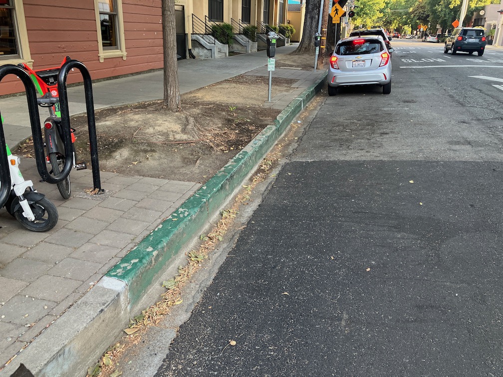
A second change since my last posting is that some parking spot paint is showing up. I had thought that parts of the striping that were still missing after quite some while were just missed, but in fact at least some of them were intended for parking regulation marking. The photo below shows a yellow curb and yellow stripe adjacent to the parking spots. I am glad to see that both the curb and the parking lane are being marked with paint. Otherwise, many drivers would fail to see, or pretend not to see, the curb color alone. This is hard to miss!
Central City Mobility Project, 21st St, yellow curb and parking marking
In California, painted curbs have the following meaning:
red – no stopping, standing, or parking
yellow – commercial loading and unloading (can also be used for passenger loading and unloading, unless otherwise signed)
white – passenger loading and unloading
green – limited time parking, as posted on a sign or the curb
blue – disabled parking (must have a license plate or temporary hanger tag)
In Sacramento, and many places in California, parking enforcement takes a laissez faire attitude towards curb colors. Except for red curbs, they are seldom enforced, and even red curb enforcement is uneven. Note that red curbs are really intended to mean what they say. If you stop there, you are in violation. A typical driver excuse for any parking violation is that they were ‘just going in for a moment’. Moments turn into minutes turn into hours, as I have observed many, many times. If you get out of your car, you are parking, no matter what the driver calls it, the law calls it parking. Parking on white and yellow curbs is a violation. Obviously commercial loading and unloading may take some time, but if there is no active loading or unloading going on, that is a violation.
I like green curbs as a solution for businesses where people pick up food and beverages. Fast food places where people order ahead. Coffee shops. My local coffee shop has a green curb right outside, and it is used for its intended purpose by some drivers. Other drivers just take it as an open free parking spot. I have reported these to city 311 as violations, but the city has not enforced so far as I am aware. More green curbs, please! (note that in the photo, the motor vehicle had just pulled into the curb, and the driver was crossing the street to pick up food at one of the businesses on the west side of 15th St; the parking meters are not functional, but the 15 minute limit is clearly posted)
green curb 15 minute parking, 15th St, Naked Lounge
Because past enforcement has been laissez faire, it will take some signing and education to make these curb colors work. Most drivers in California don’t really understand curb colors; I used to work in Nevada, and I can tell you most drivers there know exactly what they mean.
I am very pleased to see that curb colors are being more actively used in the city. Illegal parking endangers bicyclists, in particular, but also walkers and drivers. Of course something must be done to get delivery vehicles out of bike lanes and out of blocking streets and crosswalks. The city is far, far from having a plan to address that.
Other
19th St: no active work south of Q St
10th St: street being prepared for repaving and re-striping
I St: street being prepared for repaving and re-striping
5th St, 9th St: no active work
Nothing has been installed in the ‘turn wedges of death‘. I looked at the detailed design for these turn wedges (another advocate was able to obtain them), and it is still not clear what is intended for these locations. The bicycle signal at 21st and H Sts has not been installed, nor is there any sign cautioning bicyclist from using the pedestrian signal, which exposes them to high speed left turning motor vehicles.
A number of people have commented, here and other places, that my idea of converting parallel parking to diagonal parking is wrong. There should be bike lanes instead. These comments come from a misunderstanding of context. I’ve written some while ago about diagonal parking, and it is mentioned in many of my posts about parking and street design, particularly sidewalk-level bikeways and bike lane widths.
What I intend is a transportation system where:
Streets designed for 20 mph and under don’t need any bike facilities, as they are naturally traffic calmed. Bike lanes would be a waste of space. Where these streets are too wide, diagonal parking is a great solution for narrowing the street.
Streets from 21 to 30 mph need standard Class 2 bike lanes. Visual separation from motor vehicles is needed.
Streets from 31 to 40 mp need separated bikeways. In most cases these should be at sidewalk level, not at street level, but street level bikeways can be a temporary measure until the street is redesigned. These bikeways need to be sufficiently wide to accommodate passing and all types (widths) of bicycles and mobility devices.
Streets 41 mph and above are NOT streets, they are roads, and should be designed as such. No driveways, no street facing retail or commercial, few intersections. These are for getting someplace fast. These roads do not need bicycle facilities at the edge of the road. What is needed is a completely separate transportation system that keeps bicyclist safe and completely separated from motor vehicle traffic.
Is any of this real right now? No. Nothing like this exists in the Sacramento region. But I strongly believe it is the goal we should be moving towards, with haste. And diagonal parking on slow but overly wide streets provides traffic calming and more efficient use of space.
There are a number of things the City of Sacramento could be doing to better manage parking: Parking reform for Sacramento. But perhaps the most important is removing parking mandates, those city regulations that require developers to put in parking whether it is needed or will be used, or not.
The city council in January 2021 adopted the Proposed Roadway Changes document that had been recommended by staff working on the 2040 General Plan update. This is a very large document, so the relevant section on parking is excerpted. It states, in unequivocal terms:
10. Eliminate City-mandated parking minimums citywide and introduce parking maximums.
City of Sacramento, Council Report 15, 2021-01-19, 2040 General Plan Update – Draft Land Use Map, Proposed Roadway Changes, and other Key Strategies
Here we are, about two years later, and the staff is recommending considerably less in the draft plan, that action ‘could include’. Not will include, not studied on a timeline, not implemented, but maybe we will think about it, if we get around to that. Could that city have come up with any more vague and unserious language?
M-2.17 Parking Management Strategy. The City shall continue to deploy a parking management strategy that optimizes the use of existing supply, minimizes the need for the construction of new parking facilities, and promotes the use of active modes of transportation, public transit, and highoccupancy vehicles. Program components could include the following:
Adjusting parking management strategies based on goals and needs;
Adjusting parking meter hours and pricing for effective management;
Eliminating City-mandated parking minimums;
Implementing parking maximums along established transit corridors;
Allowing unbundled parking in conjunction with strategies to reduce the need for private automobiles;
Incorporating or facilitating technology such as smart-phone apps and wayfinding signage that direct drivers to open parking spaces in real-time, automated and/ or stacked parking systems, or parking technologies that improve parking efficiency in mixed-use centers and corridors;
Supporting the use of alternative modes by providing alternative programs in lieu of monthly parking passes and discounts; and
Improving branding, communications, and wayfinding signage.
City of Sacramento, draft 2040 General Plan
It should be noted that the General Plan language implies that the city has a parking management strategy, or a parking management plan. So far as the public knows, it does not. So the city is referencing something that either does not exist or has never been shared with the public. The first thing that the General Plan must include is a commitment to developing a parking management plan, with public engagement, and then sharing the plan with the public. The plan does not even mention this.
As the perfect follow-on to my post yesterday about Parking reform for Sacramento, an post today on Streetsblog USA: Here’s a Big Idea: The Larger the Car, the More You Pay to Park the Damn Thing, about a neighborhood in Montreal charging for residential parking permits by the weight and and fuel source of the vehicles. The program is intended to not just get people into small vehicles, or cleaner vehicles, or no vehicles, but to get people to think about the impact on climate and safety of their choice of vehicle. So, I’ve added that idea to my list.
The graphic below actually does not really show the huge difference between older light trucks, or SUVs, but it is a good graphic to start with.
Note: Added item to Parking fees below, in italic, based on an idea from an article in Streetsblog USA.
Following on to the discussion group topic this week of Walkable City this week, Part 3: Get the Parking Right, here is a list of my thoughts about parking reform in the City of Sacramento. Almost all applies to parking anywhere. I think nearly every one of these has been mentioned in previous posts, but I’ve not brought them together in a single place.
The City of Sacramento has a Parking Services website. Parking Services is part of Public Works.
Parking management:
Parking must be managed under a city-wide parking management plan, and the plan must be consistent with city and state policy for reducing motor vehicle use and vehicle miles traveled (VMT). The city does not have a parking management plan, so far as is known.
Parking mandates must be removed city-wide, not just for the central city and transit oriented locations.
The city should foreswear any new structure parking (parking garages or parking decks). Though the city does not have any active plans for new parking, it has had recently, and they may come back.
Require all new housing or mixed use developments to unbundle parking, meaning that no free parking is provided for residents, and all parking is available to any person who wants to rent the space. Unbundling should be phased in over five years for all existing parking.
Prohibit commercial parking lots adjacent to sidewalks, meaning the buildings must face sidewalks and not parking lots.
Property assessment of surface parking lots will be at the same value as the productive land use that existed there before, to discourage building removal and and to keeping of land in less productive or unproductive uses; this requires cooperation from the county
Parking fees:
A base rate for all parking will be set such that it covers installation, maintenance, and management of all public parking; this rate might vary by whether parking is metered or not, or might be uniform throughout the city.
Charge at least the base rate for all street parking, everywhere in the city, via meters or permits, that recovers base rate; NO FREE PARKING!
Set variable rates for residential parking permits based on the size, weight, and fuel source of the vehicle
Formally implement variable pricing of street and structured parking to achieve Shoup’s 85% utilization
Charge for handicapped spaces (this eliminates the motivation for non-handicapped drivers to illegally use handicapped spots)
Eliminate all holiday or promotional free parking; research indicates that free parking actually reduces business customers by reducing parking turnover
Pilot ideas for charging for delivery use of street parking
Parking revenue:
Parking revenue will not go into the general fund or to pay off bonds not related to parking, but be used for specific purposes related to parking and neighborhood improvement
50% of parking revenue (above base rate) will be spent on neighborhood improvements on the same streets or within parking districts
50% of revenue (above base rate) will be allocated to transit operations and transit amenities
Parking conversion to higher uses:
Add trees in the parking lane on all streets without sidewalk buffers; many of the lower income neighborhoods in the city lack sidewalk buffers and private trees, making walking unpleasant and hazardous
Do not charge for conversion of street parking to dining space, and minimize permit costs for street dining
Provide one or more short-term (20 minutes or less) parking spaces on every block with retail
Provide one or more delivery spaces per block with any retail, and enforce against double-parking for delivery where delivery spaces are available
Replace parallel parking with diagonal parking on overly wide streets, to slow traffic; most streets in the city are overly wide
Where sidewalk or sidewalk buffer space is not available for micro-mobility (bike share, scooter share) parking, street parking will be converted in sufficient quantity
Modify development standards to allow only one-side parking in new residential developments
Allow conversion of parking to bike facilities where a reduction of travel lanes is not practical (on streets 30 mph or higher)
I strongly believe that the single city action most responsible for the renewal of midtown Sacramento, all the infill development and successful business, is the removal of parking minimums (mandates) from the central city in 2012. Since that time, the city has removed parking mandates from land near major transit stops, and in 2022, the state prohibited cities from establishing mandates near major transit stops (the definition of a major transit stop is fuzzy, however).
The city has proposed, in its draft 2040 General Plan, to remove parking mandates city-wide. It remains to be seen whether pressure from politicians and suburban protectors of ‘their’ street parking spot will subvert this recommendation. 2040 General Plan draft, Chapter 8 Mobility, Goals and Policies M-2.17 Parking Management Strategy, page 8-18.
Other resources:
The High Cost of Free Parking, Donald Shoup, 1997. ISBN 9781932364965
The Parking Reform Network (PRN) website on parking minimums (also called mandates) and minimums has been recently updated and enhanced. Take a look!
I have in the past worked to compile information about parking in the central city, but it turned out to be more complex that I had realized and I never completed it. It is fairly easy to map surface parking lots, that lowest common denominator of land use, but mapping parking garages is more complicated because many of them have commercial at street level, so are not all parking, and many developments have either underground or parking in the middle of the building. All of these are much harder to document and map. So I am glad that PRN, with partner Strong Towns, is mapping.
You can see the primary map at Parking Lot Map. Use the city pulldown if you don’t go directly to Sacramento. Note that this map covers just most of downtown, it does not cover the entire central city, nor any of the rest of the city. Be sure to click on the ‘View More’ button, which provide detail that is difficult to find elsewhere, including on the city’s own website.
PRN parking lot map of ‘central city’ Sacramento
The city’s 2021 Housing Element includes policy H-1.4: Facilitate Infill Housing Development. The City shall facilitate infill housing along commercial corridors, near employment centers, near high-frequency transit areas, and in all zones that allow residential development as a way to revitalize commercial corridors, promote walkability and increased transit ridership, and provide increased housing options . (page 23)
The implementation chapter of the housing element includes Program H8. Revisions to Parking Requirements (page 46) that is included in the PRN website. The general plan update for 2040, which would implement this program, has been delayed beyond 2022. The city has not provided a target date, so far as I know.
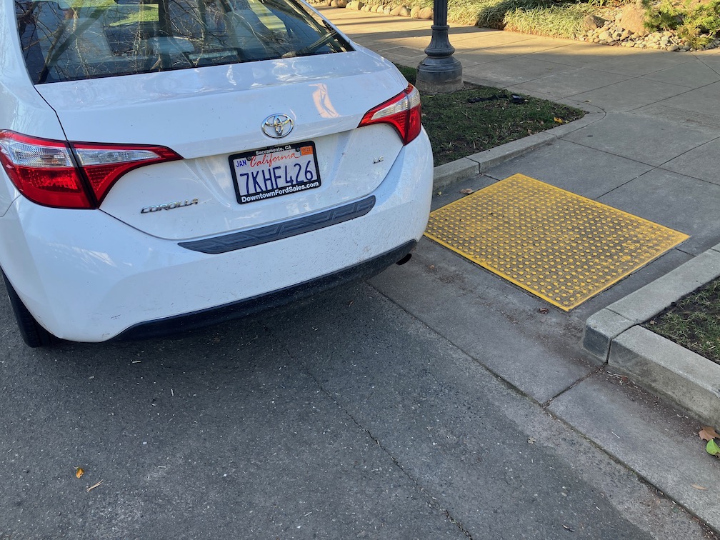
As a person who walks a lot in the central city, and some in other areas, I often see and report illegal parking to the city through the 311 app. I’m not talking about parking too long, or not paying, but about blocking driveways, sidewalks, and crosswalks. 90% of the time, the response that I get was that a parking officer was dispatched and the vehicle was no longer there, so no citation was issued. I provide the license number, vehicle description, and a photo, but the city will not use that information to ticket once a vehicle has moved. But, the real issue it that they often ignore the violation completely.
An example. I reported this illegally parked vehicle at 9:17AM. It was blocking the crosswalk over 13th St, and the ADA ramp. The remaining ramp area was not wide enough to allow a wheelchair to pass. At 11:09AM I received an email reply from the city, stating: “A Parking Enforcement Officer arrived at P ST & 13TH ST, SACRAMENTO, 95814 to find that the vehicle(s) reported were no longer on the scene.” At 7:30PM, the vehicle was still in exactly the same place. The officer was lying. The vehicle was still there. Either the officer never visited the location, or decided not to cite the vehicle.
illegally parked vehicle, 13th St, not cited
This is the sort of attitude the city has toward people who walk, or roll. They are always less important than people who drive.