NACTO street designs

I started posting NACTO street design typologies, from the NACTO Urban Street Design Guide, to Instagram, but realized this was an inefficient way to promote these. So, these are the 13 designs, presented in a slide show, in the same order as the NACTO page.

Rather than rely on these thumbnails, though, I very much encourage you to look at the pages themselves, starting in the Streets section. The purpose of the designs is not primarily to show how streets might be designed from scratch, but how existing streets can be revised to be safer, more welcoming, and more economically productive. Several of the designs have before and after diagrams. Many of the diagrams have callout numbers linked to details that might not be immediately obvious. The illustrations are based on suggested roadway width and right-of-way width. All of the designs have background information and references to locales where they have been implemented.

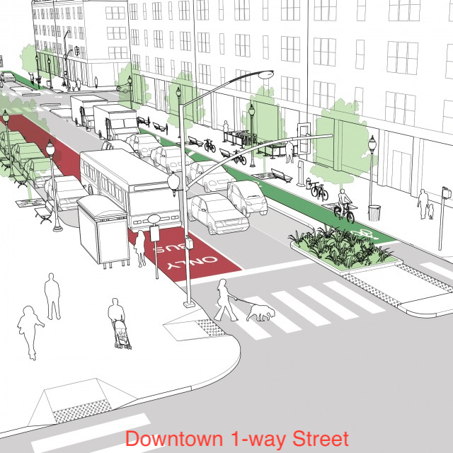
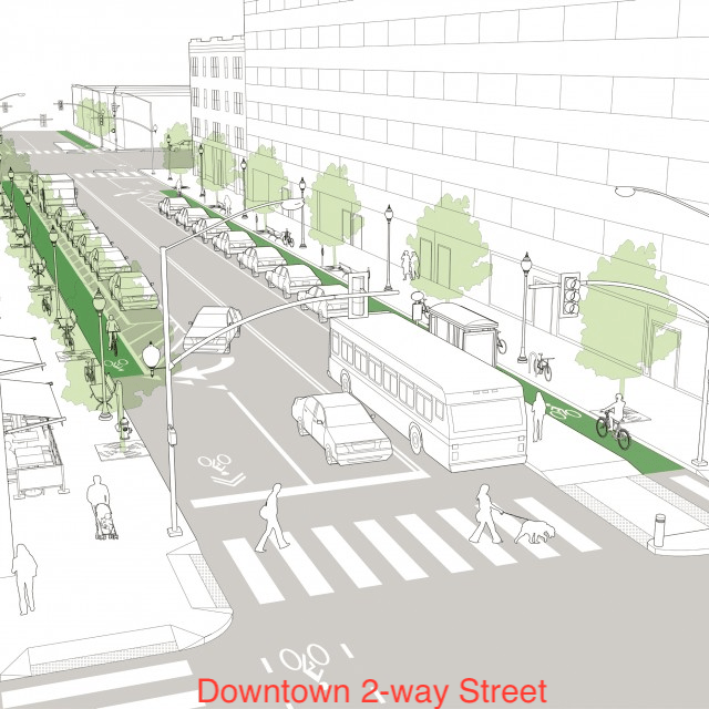
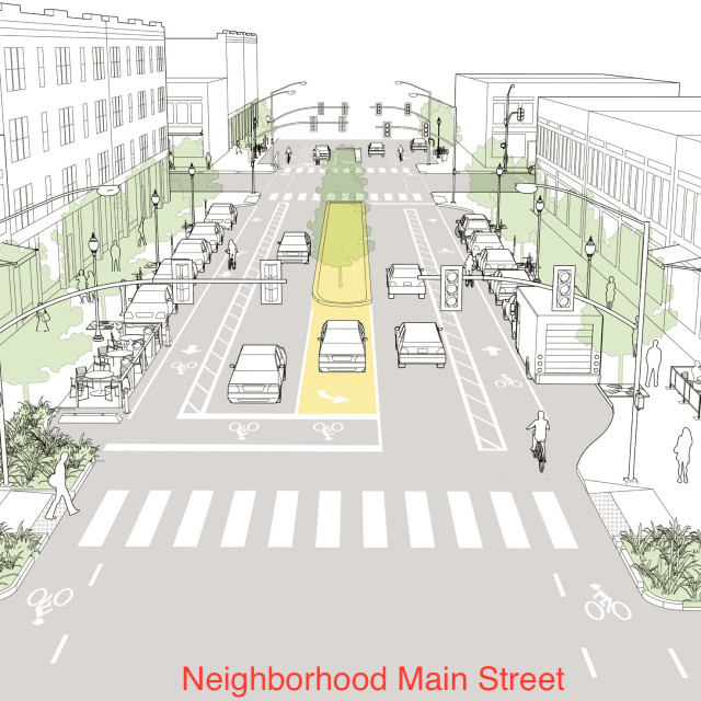
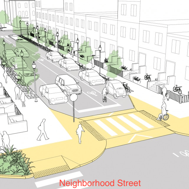
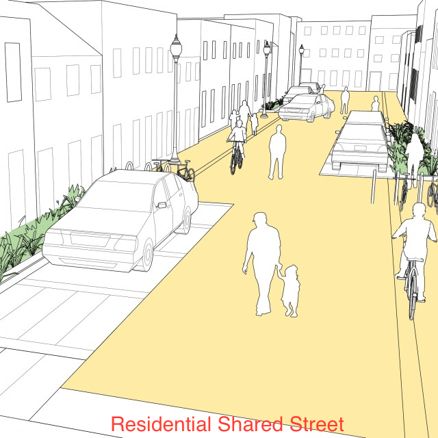
The Strong SacTown Street Design Team has continued to work on street designs and classifications, and will propose a much simpler, probably four-part, design scheme. A simple classification will communicate clearly to planners and engineers, and the public. Nevertheless, it is educational to look at the full set of NACTO designs and giving thought to what kind of street you want to live on, and travel on. When the Strong SacTown designs are complete, I will link to them.

NACTO shared micromobility report

NACTO released it’s Shared Micromobility in the U.S. and Canada 2022 ‘130 Million Trips’ report in September 2023, and the report has a summary webpage at https://nacto.org/publication/shared-micromobility-in-2022/. The report is interesting throughout, but one paragraph in particular is important for the Sacramento situation in which Lime has removed its bikes from the region, and Bird is offering few bikes. Bike share in Sacramento is more or less dead. It is clear that the model of privately owned and managed bike share does not work here. If we are to have bike share, we need a new model. I’ll have one or more posts on that shortly.

From the report (page 10):

“Shared micromobility systems that see consistent growth and equitable outcomes are typically municipally-owned or closely managed through long-term partnerships with private operators. Long-term contracts have resulted in more sustainable results for ridership and the durability of systems. The enduring viability of private sector operators remains uncertain, especially as companies with short-term permits respond to financial troubles by pulling out of cities–often abruptly–altogether. Shared bikes and e-scooters can and should be integral parts of a city’s transportation network, but that is only possible if they are consistently available and resistant to the volatility of market conditions. Partnership models where local governments have greater involvement in their shared micromobility programs generally lead to better outcomes, like more equitable pricing structures, greater investment in historically underserved communities, and ultimately, a greater likelihood of long-term viability.”

Another issue for the Sacramento area was that rental prices for bikes saw several increases during the JUMP and Uber times, and a huge jump when Lime took over. The system had become unaffordable for many former users. Lime originally offered a free for a low monthly fee rental program for people in CalFresh or similar programs, but this year changed to a half-off discount, helpful but hardly affordable. Bird has a similar half-off program. Again, from the NACTO report (page 14):

“The cost to ride a shared bike or scooter continues to rise in numerous cities, posing a threat to affordability. In a year of widespread consumer price increases–including public and private transportation modes–shared micromobility was no exception. Annual membership hikes, alongside rising e-bike surcharges, led to a 70% increase in average per-trip costs for members of station-based bike share systems from the previous year. Pay-as-you-go trips on e-bikes or e-scooters were the most expensive, with average per-trip costs more than double the typical fare of a one-way trip on public transit in the U.S. and Canada.”

I have not yet used the Spin bike share in Davis yet. I’m always in Davis with my own bike, so haven’t been motivated, but I should test it out.

NACTO protected intersection and Sac semi-protected intersection

This is Central City Mobility Project update #25.

I have been getting questions from several people about how the turn wedges being installed as part of the Central City Mobility Project are supposed to work. In particular, this applies to all of the concrete wedges, which are at the intersection of the separated bikeways, but applies most of the other wedges as well.

First, the diagram from the Central City Mobility Project design document. This is turn wedge style 3, with concrete turn wedge. The other four styles have speed bumps and vertical delineators.

diagram, Central City Mobility Project, turn wedge style 3

Second, a photo of an actual concrete wedge in place.

photo, concrete turn wedge at 21st St & P St

The issue that has been pointed out by more than one reader is that a motor vehicle driver can also cut between the turn wedge and the curb, to the left of the turn wedge, rather than to the right, as was intended by the design. Wow! That is a flaw. How did this happen?

Well, the city has designed partially rather than fully protected intersections. Not only are these protections only on one corner, but they are not designed according to NACTO (National Organization of City Transportation Offices) guidance. Here is the NACTO diagram, from the Protected Intersections page.

NACTO Protection Intersection diagram

What is different? Look at the approach from the left side of the diagram. There is a concrete island, labeled 3, which prevents motor vehicle drivers from cutting through between the turn wedge (‘corner island’ is the NACTO term) and the curb. It is likely that the area labeled 1 would also be a concrete island. This island not only protects bicyclists, but more importantly, protects walkers and shortens the crossing distance. I will include text from the NACTO page below, because the details are really important.

So, how to fix the Sacramento problem? Concrete islands need to be installed in the upstream direction, before the crosswalk. In the case of the photo above, this would be where the photographer is standing. Without such protection, this cannot be considered in any way a protected intersection or separated bikeway (protected bikeway). The radius of the turn wedge is also much greater than the NACTO recommendation, 30 feet rather than less than 18 feet (see second bullet below). So we are back to ‘turn wedges of death‘. I have to say, this is typical of the city, to take a good idea and sort of implement it.

Thank you to the reader who pointed out this design flaw, and caused me to look more closely, and think more closely.

Read More »

NACTO downtown streets

There are a few streets in Sacramento which are wide enough to host many activities and modes of travel, with reallocation of the roadway width to meet a new vision of a livable, walkable city. Two NACTO diagrams are below. The first, a downtown one-way street, is interesting to me because it shows a better use of space without having to change from one-way to two-way. I have always been opposed to one-way multiple lane streets because they present the multi-lane threat to people crossing the street, when one driver stops but others do not. This is one of the most common causes of fatalities for walkers, and why it must be eliminated. However, if the design is changed, the street becomes much safer, and the multi-lane threat is reduced or eliminated. Check the NACTO page for an alternate design.

diagram of NACTO downtown one-way street
NACTO downtown one-way street

I believe there should be high frequency bus service on J Street from 5th St to the university, and if J Street remains one-way, paired service on L St. This diagram would be a great model. Current service is 15-minute frequency on part of the route, but only 30-minute on part. Service should be at least 10-minute, maybe even more frequent. This would be a good design for that service and for those streets. Yes, L Street is not continuous, due to a broken street grid, so either H Street or Folsom Blvd could be used to connect.

Other streets that might remain one-way, but only with redesign, include the 9th-10th couplet, 15th-16th couplet, 19th-21st couplet, and P-Q couplet. The W-X couplet that bounds the Hwy 50 freeway would have to remain one-way due to freeway onramps and off ramps, but must be narrowed significantly. It is nothing but a traffic sewer as currently designed, and the motor vehicle capacity of the street is completely unneeded, even during rush hours.

Read More »

NACTO neighborhood main street

Second post on NACTO street types, the neighborhood main street, from the NACTO Urban Streets Design Guide. See NACTO yield street for the first, and some background on NACTO.

NACTO Neighborhood Main Street, two-way

The street has typical modes: motor vehicle lanes, bicycle lanes, parking areas, wide sidewalks. Features include curb extensions, short left turn lanes but long center medians, pedestrian scale and intersection lighting, planting strips with trees, but perhaps less than the yield street. The most important aspect is that there is only one general purpose travel lane per direction, meaning that the prudent driver controls the speed of other drivers. The design speed and posted speed might be as high as 30 mph, but would probably be less.

Read More »

NACTO yield street

NACTO (National Association of City Transportation Officials) is the lead organization for progressive transportation cities. It is in strong contrast to regressive organizations such as League of California Cities which exist primarily to serve suburban areas. Of course part of the difference is the size of the cities, as NACTO tends to include large cities, while League of California Cites tends to include small cities, but it is really a difference in attitude about what cities are for. NACTO cities are cities for people, League cities are cities for cars and businesses. Take a look at CalCities Partners to see who the League likes. Unfortunately, City of Sacramento is a member. But on the plus side, Sacramento is also a member of NACTO.

In upcoming posts about Street Design Standards, I will be using NACTO materials often, primarily from the Urban Street Design Guide, but from the Transit Streets Design Guide and Urban Bikeways Design Guide as well.

I believe that the Street Design Standards should include both overviews of different kinds of streets, to provide city staff, city council, and most importantly, the public, a clear picture of what a new or reconstructed street will look like and feel like. Design details are also important, but design details without context just allow staff to build streets that follow the rules but neglect safety and livability.

So, first up, the overall design that NACTO calls a Yield Street. The portion of the street devoted to moving motor vehicles is less than most of the streets in Sacramento, but the portion devoted to street-related uses is more. The most prominent difference is that the travel part of the street is not two lanes, but a shared area (hence, the yield name) where drivers must negotiate to pass and adjust for variable widths as parking and other uses vary. This is easily a street for a 20 mph design and posted speed limit, as all local streets should be. Note also: wide planting strips with trees, perpendicular ADA ramps, high visibility crosswalks, curb extensions on most corners, small corner radii, pedestrian scaled lighting, and reduced but not eliminated parking. The diagram shows just residential uses, but the design can easily accommodate corner stores.

NACTO Yield Street diagram
Read More »