The second post by Strong SacTown to improve and promote the City of Sacramento update to its Street Design Standards. Other posts at tag: street design standards.
Over time, the major use of our streets and public right of way has shifted: from pedestrians and horse-drawn carriages, to streetcars and bicycles, and — over the last several decades — to ever larger private vehicles. In designing our streets for vehicle throughput, our network of roads has become a transitional space focused on getting as many cars from Point A to Point B as fast as possible. This means dedicating an ever increasing amount of space to travel and parking lanes, with only the space left over from vehicle use — if any — allocated to people: pedestrians, bicyclists, and public transit.
Strong SacTown Street Design Team will be posting a series to improve and promote the City of Sacramento update of their street design standards. This is the first. You can follow their website at https://www.strongsactown.org/, and the series at https://www.strongsactown.org/tag/street-design-standards/. Getting Around Sacramento / Dan Allison is participating in the team planning and writing, but these posts are the work of the team.
“We are Strong SacTown — Streets for People, a group of Sacramentans advocating for updated street designs that will rank safety, livability, and economic vitality above vehicle throughput or speed; where congestion relief will not be the goal in street design.
The City of Sacramento is updating the street design standards for the first time since 2009. The city is embarking on this effort as it is becoming increasingly apparent that the existing standards do not meet the needs of all users in the modern era.”
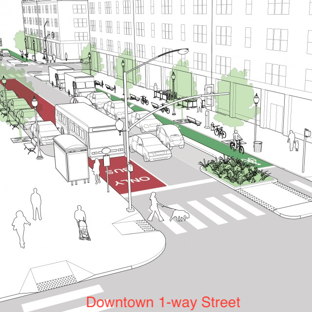
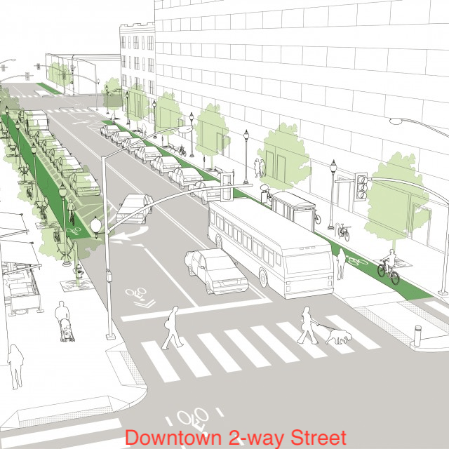
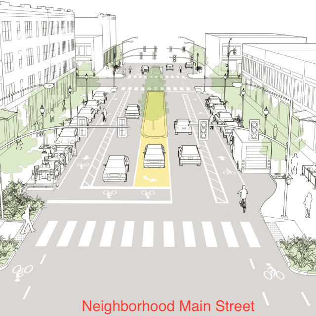
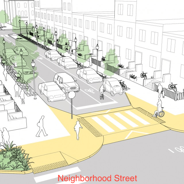
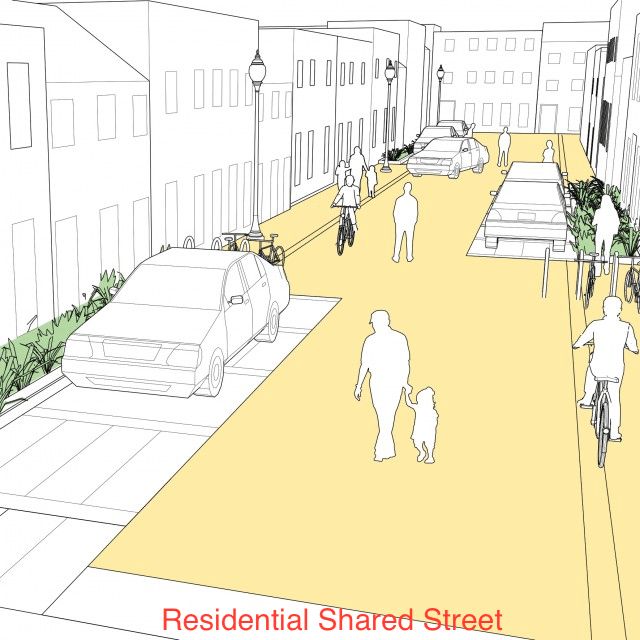
I started posting NACTO street design typologies, from the NACTO Urban Street Design Guide, to Instagram, but realized this was an inefficient way to promote these. So, these are the 13 designs, presented in a slide show, in the same order as the NACTO page.
Rather than rely on these thumbnails, though, I very much encourage you to look at the pages themselves, starting in the Streets section. The purpose of the designs is not primarily to show how streets might be designed from scratch, but how existing streets can be revised to be safer, more welcoming, and more economically productive. Several of the designs have before and after diagrams. Many of the diagrams have callout numbers linked to details that might not be immediately obvious. The illustrations are based on suggested roadway width and right-of-way width. All of the designs have background information and references to locales where they have been implemented.
The Strong SacTown Street Design Team has continued to work on street designs and classifications, and will propose a much simpler, probably four-part, design scheme. A simple classification will communicate clearly to planners and engineers, and the public. Nevertheless, it is educational to look at the full set of NACTO designs and giving thought to what kind of street you want to live on, and travel on. When the Strong SacTown designs are complete, I will link to them.
AB 413 (2023, Lee), the Daylighting Saves Lives bill, became law last year. It prohibits stopping, standing or parking a vehicle within 20 feet of any crosswalk, whether marked or unmarked. CalBike: Intersection Daylighting Becomes California Law. The law also details that it applies to the approach side (upstream), and is 15 feet if a curb extension is present. Until January 2025, only warnings can be issued. Either red paint or a sign is required. It does allow a ‘local authority’ (city or county) to establish a different distance with justification and by painting or signing a different distance. Another exception is for commercial vehicle loading and unloading, where the specific crosswalks are identified in ordinance and they are marked by paint or signing. Bicycle and scooter parking can be placed within the 20 feet, which is great since much of the city lacks sufficient parking for these devices.
red curb offset for daylighting, L St at 18th St
I fully support this law, though I would have modified it in some ways. I don’t think the 15 foot distance where a curb extension is present is necessary. The daylighting here can be ‘enforced’ by design. I would have made an exception for passenger loading and unloading (white curb), not for commercial vehicle loading and unloading (yellow curb). Commercial vehicles usually don’t stay long, but they are almost always large and effectively block visibility, whereas private vehicles are usually smaller and block visibility to a lesser degree. Of course we need commercial loading and unloading zones, many more than exist, so that bike lanes and travel lanes are not blocked, but approaching crosswalks is not the right place. Most drivers don’t understand what curb colors mean anyway, but that is a matter for education, not for not using them. Green, by the way, signifies limited time parking, which is posted on signs or stenciled on green curbs.
So, how will the City of Sacramento respond to this? The city has over 700 signalized intersections. It is unknown how many total intersections there are, but it is likely in excess of 15,000, and for most intersections there are four crosswalks, so in excess of 60,000 crosswalk approaches. There isn’t and likely won’t ever be funds to mark or sign all these. So how should the city select locations? One criteria that should not be used is how much demand there is for parking on a particular street. This is about safety, not parking. So possible criteria, similar to that presented for ‘no turn on red’ (no turn on red for Sacramento?):
locations of crashes: This is a no-brainer. Red curbs or signs should be installed at any intersection where there is a history of crashes involved walkers and bicyclists. This should be city policy, to install signs at any location where SWITRS indicates there is an issue, or immediately after any crash.
crosswalks with a high walker count: This is probably the most beneficial for safety. The problem is that the city does not collect data on the number of walkers using crosswalks (marked or unmarked), so it would not know where to start. The lack of data collection is a failure on the part of the city, but it is nevertheless a fact.
There are other possible criteria. The city’s Vision Zero Action Plan (2018) identified ‘Parking Restrictions Near Intersections’ as a countermeasure specifically for drivers making left or right turns impacting walkers and bicyclists, with a high efficacy, low cost and low complexity. The Top Five Corridor Study identified Marysville, El Camino, Broadway/Stockton, South Stockton and Florin segments as dangerous roadways for safety improvements. Unfortunately the Vision Zero effort was limited to corridors, and not high injury intersections. It should have also identified the top five, or ten, intersections. Nevertheless, the city does have data on these intersections that could be used to identify high priority fixes.
The separated bikeways with turn wedges on P Street, Q Street, 9th Street, 10th Street, 19th Street, 21st Street, and I Street largely address the issue without needing additional marking or signing, on the side on which the bikeway is installed, but the other side would still need marking or signing. The separated bikeway on J Street has daylighting at some but not all crosswalks.
The highest safety benefit accrues to curb extensions, temporary at first and permanent in the long run. Temporary extensions are inexpensive and can be installed quickly (Strong SacTown quick-build street safety), while permanent extensions are more expensive and require planning. Sometimes curb extensions require relocation of drain inlets, which increases their cost.
Strong SacTown, the local affiliate, or local conversation of Strong Towns, has formed a committee to develop ideas for the update of the City of Sacramento Street Design Standards, which is currently underway. These standards, from 2009, are very much in need of an update. They do not include many modern or innovative ideas, and in fact don’t include much. The committee has adopted the city’s own Streets for People moniker for its efforts, as they believe that perspective should inform not just the Active Transportation Plan, but all city documents and efforts in transportation, including the street design standards.
The Street Design Standards will be guided by and consistent with the 2040 General Plan, soon to be adopted.
The group has recently formed, and will be meeting in person about every two weeks. If you have a strong interest in street design, you may want to join. You do not need expertise ahead of time, you do not need to be a planner or engineer, just a person with passion for better and safer streets. But you will develop some expertise as the committee does its work.
The committee is searching out innovative plans from other cities that might be a model for us. We are also looking at progressive design guidance, including but not limited to NACTO’s Urban Street Design Guide and Urban Bikeway Design Guide (which is being updated, with several pieces already published).
If you wish to join in, or just find out more, contact Matt Anderson, the committee lead, matthew.n.anderson@gmail.com.
PROWAG (Public Right-of-Way Accessibility Guidelines) from the US Access Board have now been officially adopted. I’ve only begun to review them, but a few things grabbed my attention right off the bat. From PROWAG:
“At an intersection corner, one curb ramp or blended transition shall be provided for each crosswalk, or a single blended transition that spans all crosswalks at the intersection corner may be provided. Where pedestrian crossing is prohibited, curb ramps or blended transitions shall not be provided, and the pedestrian circulation path shall be either (a) separated from the roadway with landscaping or other non-prepared surface or (b) separated from the roadway by a detectable vertical edge treatment with a bottom edge 15 inches maximum above the pedestrian circulation path.”
This means that the diagonal access ramps at corners, which are common in suburban areas and even a few urban areas, are no longer legal for installation. For any alterations of curbs, sidewalk, or corner, new ramps must be two to a corner, perpendicular, or the ramp must cover the area of both sidewalks. See photo below.
diagonal curb ramp, now illegal under PROWAG, installed May 2023 by Sac City
Secondly, the pedestrian prohibition signing in common use in the City of Sacramento and many other places is now illegal, because it does not meet the criteria of the bottom edge no more than 15 inches above the sidewalk. See photo below, showing a newly installed curb ramp where the ramp does not extend the full width of both crosswalks. Again, any alteration of the curb, sidewalk, or corner requires compliant design. Of course the majority of these pedestrian crossing prohibitions are unnecessary, and were installed to ease motor vehicle traffic and not to protect walkers, so most should simply be removed, and legal curb ramps installed. The one exception would be freeway on and off ramps that have not been modified to be safe under any conditions.
pedestrian crossing prohibition, now illegal under PROWAG
This phrase summarizes the street network we have in the City of Sacramento. With a very, very few exceptions, every single street is too wide and too fast, across the entire range from residential streets to traffic sewer arterials. These streets kill and injure incredible numbers of people every year. Walkers, bicyclists, drivers, passengers, no one is immune to the danger that these poorly designed streets present. Though rankings change year to year, and depend on details, Sacramento is at or near the top of crash rates for the state. We probably don’t have worse drivers than other cities, we have worse streets.
The city has promised that it will update the Street Design Standards that have created this hazard. Maybe soon, maybe not for years. In fact, the existing standards don’t even have all that much detail, so a lot of the streets were apparently designed on the whim of traffic engineers, not even on standards. MUTCD (Manual for Uniform Traffic Control Devices) and CA-MUTCD will not be considered acceptable roadway designs since they emphasize motor vehicles over all other roadway users. NACTO (National Association of City Transportation Officials) or European standards such as the Netherlands CROW will be referred to as needed.
The new standards must ensure that we never build an unsafe roadway again. The goal must be no fatalities or severe injuries, no matter how drivers behave. Sacramento must be a true Vision Zero, safe systems city, not the lip service, we will fix things someday, when we have the money, that it is now.
What should the new standards be like?
There should be separate documents, or at least clearly separate sections, for new construction and for healing existing designs.
The state and federal roadway functional classification system (FCS) should not be used. Instead, a system that addresses the intended purpose of streets including ALL users should be used. The FCS is in large part responsible for the mess we have now. It represents that traditional traffic engineer focus on maximizing motor vehicle volume and speed. See SacCity street classification for more information.
New construction standards:
will emphasize limited roadways, one lane in each direction, and would include designs for two lanes in each direction in exceptional circumstances
design speeds and posted speed limits must match
base design speed is 20 mph
roadways over 20 mph must have bike lanes; over 30 mph must have separated bikeways
no roadway will have a design speed over 40 mph. Anywhere. Ever.
intersections will be designed so that it is clear that crosswalks, at sidewalk level, continue through the intersection, and motor vehicles are the guests
all new developments will be designed with a street grid of 1/4 mile
rolled curbs will not meet standards, however, streets without curbs may be used if the design speed is 10 mph
Healing existing roadways:
no street will be repaved without consideration being given to reallocating right-of-way width to walking, bicycling, transit, and sidewalks buffers for trees
the intent of reallocation will be to achieve the same design as new construction
on-street parking will be retained for its traffic calming effect, however, removal of parking will never prevent reallocation to higher uses
for overly wide streets, parallel parking will be converted to back-in diagonal parking in order to narrow roadways for safety
streets without a tree canopy will have trees added, in parking lanes if no other space is available
the city will adopt responsibility for maintenance of sidewalks, in the same way that they are responsible for pavement
designs will be available for closing sections of street temporarily or permanently for dining or community events
designs for diagonal ADA ramps will not be part of the updated standards; only perpendicular ramps will meet standards
My intent here is to provide something simple, summarizing beyond the details of previous posts on Street Design Standards.
City of Sacramento Public Works staff has told the Active Transportation Commission that an update to the Street Design Standards will start soon. But the General Plan says otherwise. From the plan, Implementation Actions, pages 8-28 to 8-29:
M-A.10: Street Design Standards Update. The City shall review and update City Street Design Standards as needed to ensure they adequately support objectives for prioritizing people throughput, safety, and efficient transportation management. Responsible Entity: Department of Public Works Timeframe: Mid-term (2030-2035)
This timeframe indicates that the update will not even start until 2030, six years after the adoption of the plan in 2024. Six years of Public Works enforcing outmoded and dangerous street designs on the public and on developers. Hopefully the plan is out of date, and staff is correct that it will start soon.
Yes, I had promised quite some while ago a summary of my many blog posts on the Street Design Standards update. Coming soon to a blog near you.
At the June 15, 2023 meeting of the City of Sacramento Active Transportation Commission meeting, agenda item 5 was ‘Stone Beetland Planned Unit Development – Amendments to the Bicycle Master Plan’. The topic was about modifying the bicycle master plan so that the new bicycle facilities in this development connected with other facilities already in the master plan. But since it is the purview of the commission is to address all active transportation topics, several members of the public and of the commission asked questions and commented on the transportation aspects of the overall development plan.
I asked why the streets were so wide, ranging from 42 feet to 74 feet, with the most common being 59 feet. Wide streets encourage drivers to speed, and so are significantly less safe than narrow streets. Another commenter and two commission members also asked about this. A 42 foot right of way should be the upper limit of street width, not the lower limit. When asked, the developer said that they had wanted narrower streets, but City of Sacramento Public Works forced the wider streets. The excuse from Public Works was apparently that as the area developed, there would be more traffic and wider streets were necessary. This is a self-fulfilling prophecy: building wider streets induces more traffic, and so the wider streets are needed to handle the motor vehicle traffic that the wider streets induced.
There were other questions about this development, including whether streets will have sidewalk buffers of sufficient width to host trees as they mature, and whether bicyclists will be able to leave the neighborhood since Cosumnes River Blvd is a high speed (55 mph!), high volume arterial that has paint-only bike lanes (which should not even be legal on a road with 55 mph posted speed limit), that very few bicyclists feel comfortable riding on. No matter what bicycle facilities the developer provides, people will be trapped in their neighborhood, unless they can drive and want to drive.
Public Works is the enemy of safe streets. Again and again the safer streets proposed by city planners and developers are nixed by someone in Public Works. There are car-brained engineers in Public Works that think the sole purpose of streets is to carry the maximum number of motor vehicles at the maximum possible speed. Despite the world changing around it, and the clearly documented hazard of wide fast streets, Public Works is living in the past, dedicated to a cars-first transportation system. I am not denying that there are progressive people in Public Works, and in Community Development as well, but somehow the outcome is always worse and less safe than the public wants.
This is an update to the update on work being done on corner ADA ramps in the Sacramento central city, apparently as part of the Central City Mobility Project.
So far as I have seen, curb extensions are not part of this project.
There are now a number of locations where the concrete ramp is being cut so that the detectable warning strip can be installed, but the curbs are not being touched. See below for an example.
Q-St & 16th-St, SW corner, ADA ramp construction
One of the corners I have been monitoring, 21st St and O St northeast corner, is complete, but with temporary patches that make the ramps useable, though ironically still blocked by folding barricades and caution tape, which absolutely does not meet ADA guidelines for contruction signing and safety. This seems to be the pattern with the city, trying to make things better, but not paying attenteion to the details. I don’t know when the asphalt will be restored and the corner opened. Maybe the contractor is waiting until all the corners are ready before patching, though that would be stupid.
21st-St & O-St, NE corner, completed corner with ADA ramps
I am still not able to make sense of the asphalt cuts that are being done on the corners where the curb will be or has been modified. I’m guess that there was a standard cut design, implemented everywhere, no matter what the actual project.
Walking around the central city, it appear that most of the corners which did not have ADA-compliant ramps will have them when the project is done, but some may not. I don’t know what the criteria is for which corners are being done, and which are being done at a higher level of replacing the curbs and widening the ramps. Many of the existing ramps are narrow, with edging curbs, which was apparently the design at the time they were placed, but the new corners are a different design, with a sloping area between the two ramps, similar to the diagram below, from the 2020 Department of Utilities Standard Specifications: Transportation drawings, not from the 2009 Department of Public Works Street Design Standards, which contain no ADA diagrams. I think the detectable warning strip width is at least 60 inches on the new installations, which is an improvement. The 48 inch width does not allow two people to stand on the strip. Corners with new curb extensions seem to have 72 inch strips.