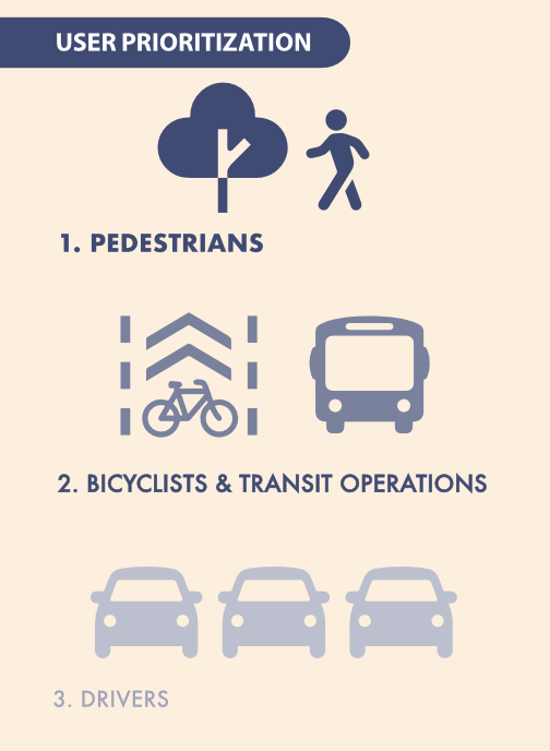
Below is a graphic from the City of Sacramento 2040 General Plan (Chapter 8 Mobility Element, page 8-9). As a transportation advocate, I obviously have a bias, but I think this is the most important graphic, and the most important message in the entire general plan.
User Prioritization from City of Sacramento 2040 General Plan
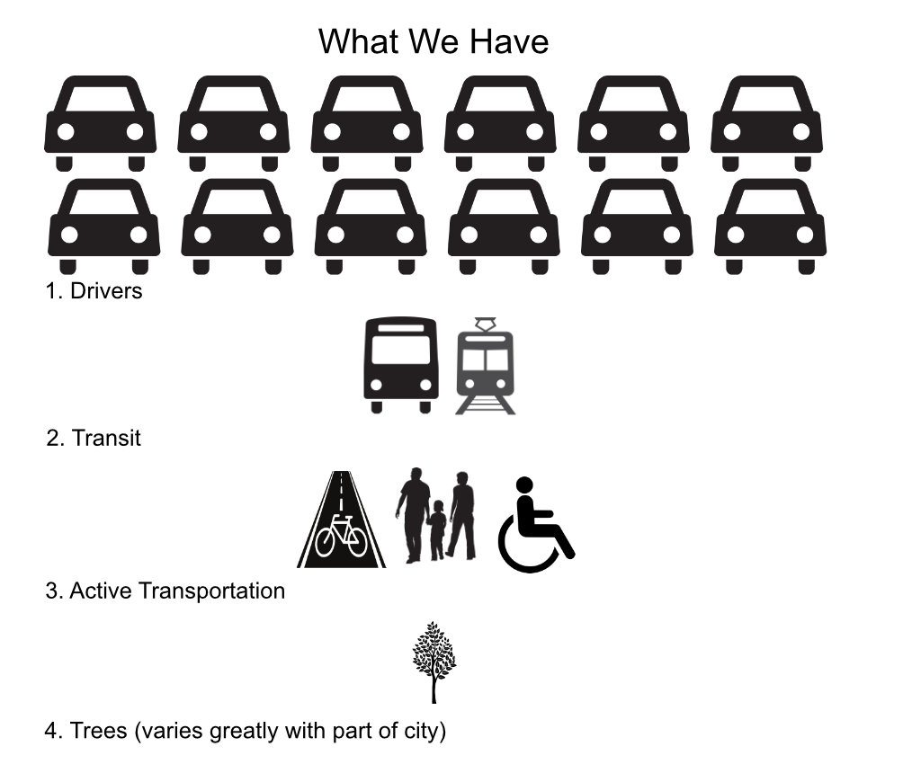
This is in complete contrast to the transportation system we have built. Below is the transportation system we have. One could argue endlessly about how this varies with parts of the city, and whether active transportation should be lumped together, but the graphic communicates the problem.
I follow the city’s transportation projects, some in great detail, others only superficially. There are far too many for one person to cover, or even a group of people.
What I see in these projects is a very gradual shift from what we have to what we want. We might reduce general purpose (car) lanes, in number or width, but not always. We might add bicycle facilities. We might, occasionally, improve sidewalks for people walking and rolling (but not if we can get away with making property owners do it). We might make it easier for transit. Though the central city, and some neighborhoods outside the central city, have a reasonable tree canopy, north and south Sacramento are largely lacking a tree canopy, and every transportation project neglects solving this issue. We don’t plan in trees from the beginning, saying we’ll get to them later in the process, but at the end, they are usually missing.
We have invested hundreds of millions of dollars in making things better for drivers and motor vehicles, and very, very little on anything else. It is time to almost completely reverse that, so spend nothing on drivers and motor vehicles, and almost everything on transit, active transportation, and trees.
Cross-sections
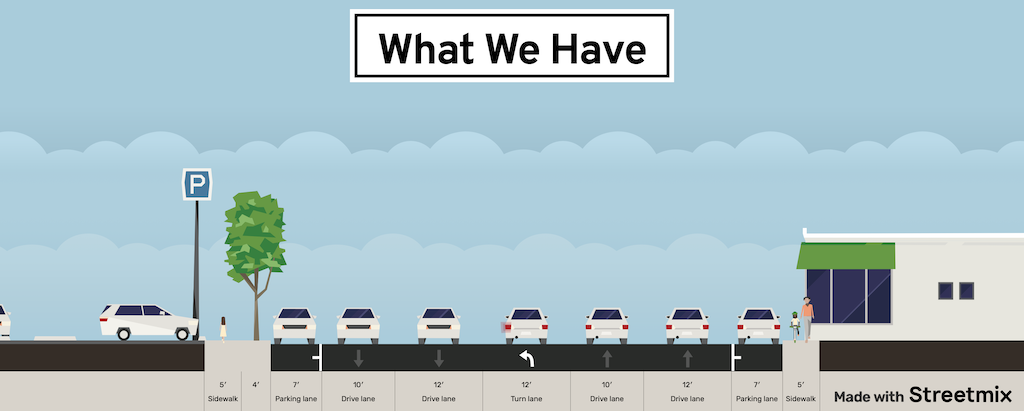
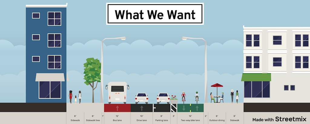
Another way of exhibiting this is street cross-sections. These are from StreetMix (https://streetmix.net/), for an 80 foot right-of-way. Neither is meant to represent an actual street, but rather illustrative of the way in which we can allocate street space to different uses.
In the ‘what we have’ cross-section, motor vehicles are dominant. Sidewalks are narrow, trees are present but in few numbers, and probably not healthy because they have been squeezed into small spaces, bicycle facilities are not present or are of low quality, ample space is allocated to cars in general purpose lanes, and left turn lanes and right turn lanes. Ample parking is provided, whether needed or not. I have intentionally picked low density and low productivity uses to line this roadway, parking lots and single story buildings, though most often there is a parking lot before you even get to the building. StreetMix only offers a few options for each element, and what is shown is what is available.
In the ‘what we want’ cross-section, private motor vehicles are strictly limited. There is parking, but not ample parking. Transit, where is makes sense to have it, operates in its own right of way. Since the general purpose lane is one-way, a two-way bikeway (cycle track) is provided so that bicyclists have more freedom of movement than drivers. Sidewalks are ample, 8 foot on average. Sidewalk buffers are ample, 8 feet on average, so that trees have space to grow and thrive. The buffers are not just for trees, though, they can host dining and bike racks and street furniture. Reflecting the people-centered nature of this street, there are higher density uses of housing and business, and the buildings come to the sidewalk rather than being set back. The city is not proposing ‘what we want’ anywhere.
This street is far, far safer than multi-lane streets. By reducing the amount of space devoted to motor vehicle through traffic, space is freed up for people, people walking, people bicycling, people eating and socializing, and people just hanging out. It is quiet. It is friendly. It not only feels safe, but feels welcoming. This reflects my axiom that we should design streets from the outside in, not from the inside out (street design from the outside in). Outside in preferences walkers and trees, inside out preferences drivers and motor vehicles.
Update: Edited to add more accurate segments and cross-sections, make additional comments on design, make clear that the 6th-7th cross-section should be similar to the 5th-6th cross-section, with light rail tracks in their own right-of-way rather than the southern one (Line 1) being in a shared or mixed use lane with private motor vehicles.
Note: I realized last night in thinking about H Street that I had accepted too much of the city’s compromise to prioritize motor vehicle traffic and preserve parking. This section of H Street could be a model for how to do streets right, but the 30% design presented is not that. I’ve changed some recommendations and reorganized the post content.
Key points:
Mixed use transit lanes prioritize motor vehicle traffic over transit safety and efficiency. The mixed use lane between 6th Street and 7th Street must be changed to a dedicated transit lane.
The two-way bikeway must be a minimum of 10 feet in width (5 feet each direction) in order to provide safety, usability, and maintainability. This will require changing parking and/or general purpose lanes widths.
Two-way bikeways must have bicycle signals at every intersection. This design does not.
Where there are two general purpose travel lanes in same direction, as between 9th Street and 10th Street, only one lane needs to be 11 feet, while the other must not be more than 10 feet. This is generous, as most modern recommendations are between 9 and 10 feet. The safety advantages of narrower lanes are well documented.
Maintenance of on-street parking is clearly a priority in this design. While on-street parking can slow traffic, and is appropriate in retail and residential areas, here it is for the convenience of workers who could park in the ample parking garages and lots along and near H Street. Where roadway width is needed for safe and high quality bikeways, on-street parking can and should be removed.
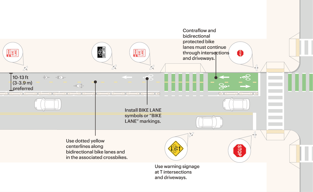
The H Street Bikeway to Sacramento Valley Station project is presenting at the SacATC meeting this week, Thursday, February 19, starting at 5:30 PM. A community workshop will be held Thursday, February 26, starting at 5:30 PM at city hall, room 1119. This project is part of a large grant-funded project (TIRCP – Transit and Intercity Rail Capital Program) to improve Sacramento Valley Station. H Street is the main access route from the station for bicyclists. There are no safe routes to the station, at this time.
The project will create a two-way separated bikeway (also called a cycle-track) on H Street between 5th Street (the station) and 10th Street and 9th Street with existing bicycle facilities.
For the segment images, I have used the SacATC presentation. For the segment cross-sections, I have used the diagrams from the SacATC staff report, as they include measurements, which are critical for determining the safety and usability of the bikeway. StreetMix diagrams usually include measurements, but the ones in the presentation do not.
Transit priority
The TIRCP grant of which this project is a small part, is intended to support transit use to and from Sacramento Valley Station, to ensure that the station is the effective transit and rail hub that the city, region, and state want.
I support the double-tracking of light rail in the segment between 5th Street and 7th Street. Single-track light rail segments create pinch points where one train may need to wait for another, slowing the entire light rail system. The diagrams also seem to indicate a crossover between 5th Street and 6th Street, which is valuable for routing trains when there are blockages.
Segments
Bicycle facilities within Sacramento Valley Station, west of 5th Street, are not part of this project. I have not seen any recent information on how bicyclist circulation will be handled within the station area.
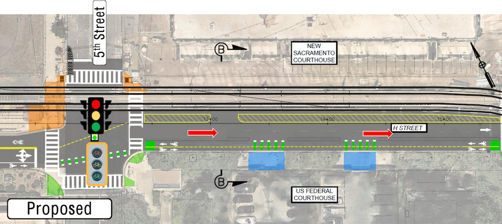
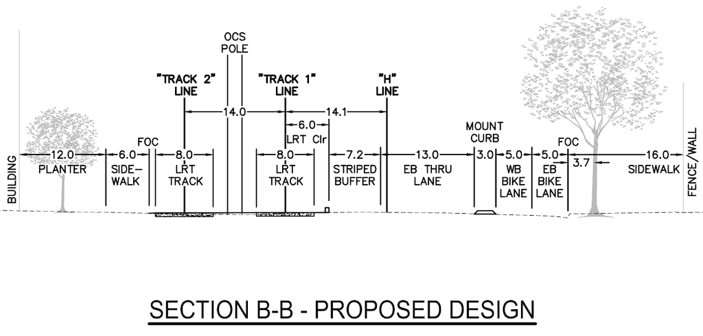
5th Street to 6th Street
This segment is reasonably well designed but could be improved. Double-tracking of light rail removes a bottleneck for the Gold Line/Green Line.
H St Bikeway between 5th St and 6th St, proposed (from SacATC presentation)
The buffer between light rail and general purpose lane (7.2 feet), and the overly wide general purpose lane (13 feet), totaling 20.2 feet, waste roadway width that could be devoted to the two-way bikeway. A better allocation would be, from right to left, 12 foot bikeway, 3 foot mountable curb, 3 foot buffer, 11.2 feet general purpose lane, and 4 foot buffer.
H St Bikeway from 5th St to 6th St, proposed cross-section, 92.5 feet ROW?, 52.5 feet FOC (from SacATC staff report)
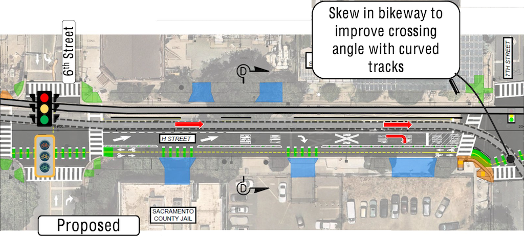
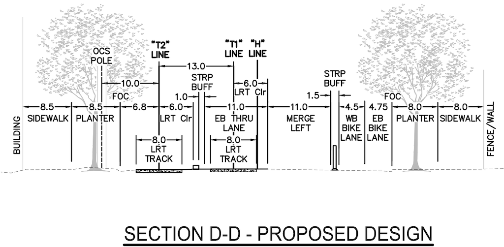
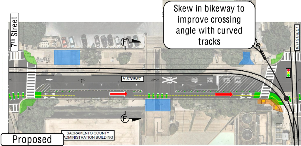
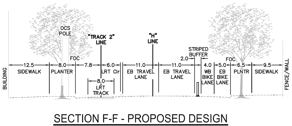
6th Street to 7th Street
The segment shows a light rail track sharing with motor vehicle traffic. This is inappropriate, and removes the advantage of double-tracking, since trains can be stuck in congested motor vehicle traffic. The southern or right hand lane should be a combined through and right turn lane, and the northern or left hand lane should be eliminated. The design constrains the bikeway to 4.5/4.75 feet, rather than the minimum of 10 feet. Diagrams below.
H St Bikeway from 6th St to 7th St, proposed (from SacATC presentation)H St Bikeway between 6th St and 7th St, proposed cross-section, 80.5 feet ROW?, 47.5 feet FOC (from SacATC staff report)
The 6th Street to 7th Street cross-section should be designed similarly to the 5th Street to 6th Street cross-section, shown below, with the suggested modifications to roadway allocation, as above in 5th Street to 6th Street segment.
H St Bikeway between 5th St and 6th St, proposed cross-section(from SacATC staff report)
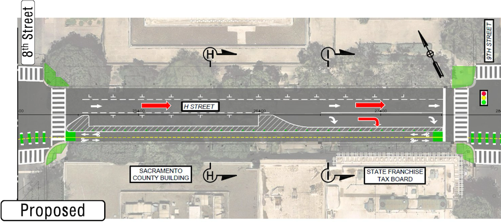
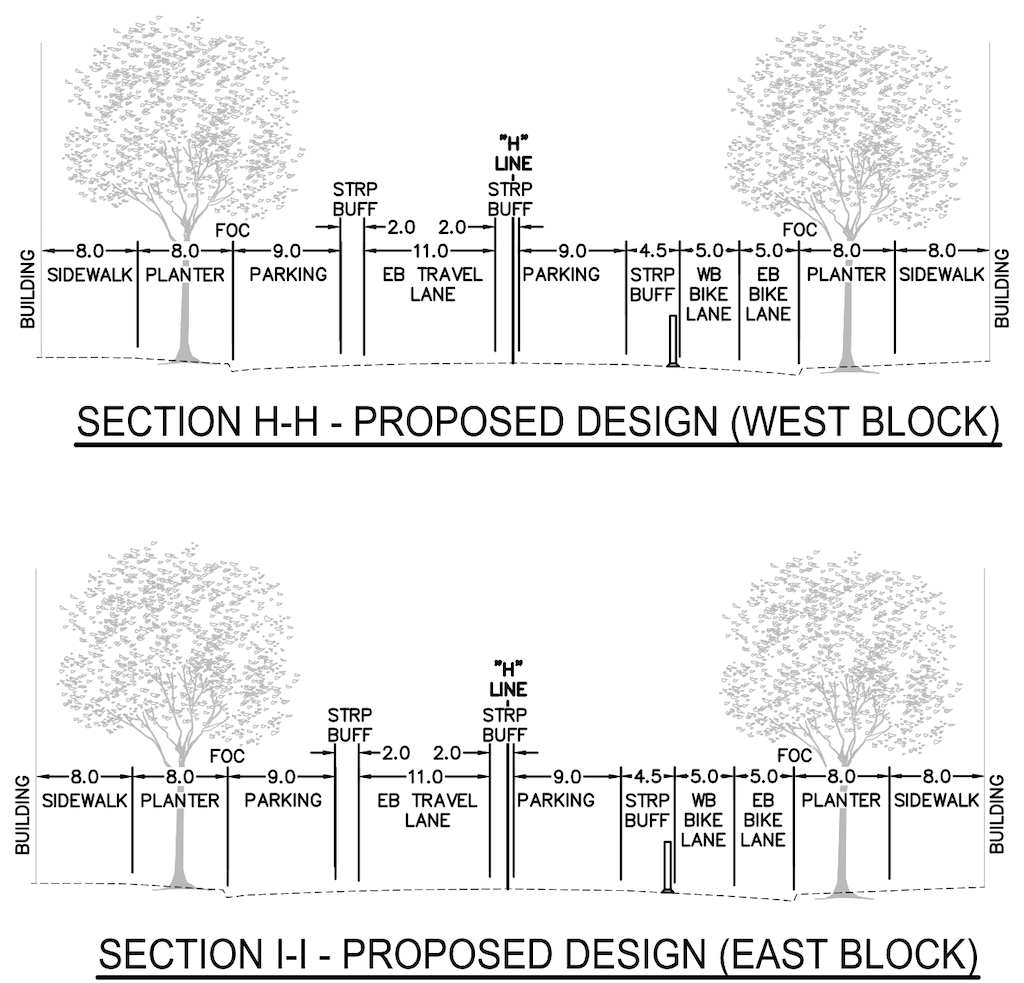
7th Street to 8th Street
The preservation of parking in this segment is ridiculous. There is a parking garage of large capacity directly north across the street, so there is no reason for on-street parking here. The city’s desire to maintain parking in this section is in fact the reason why the existing Class III (sharrows only) bike facilitiy on H Street is dangerous and unpleasant. Again, retention of parking constrains the bikeway to 4.0/5.0 feet rather than the minimum 10 feet. Diagrams below.
H St Bikeway from 7th to 8th, proposed (from SacATC presentation)H St Bikeway from 7th St to 8th St, proposed cross-section, 83.3 feet ROW?, 48.6 feet FOC (from SacATC staff report)
8th Street to 9th Street
The segment design is reasonable.
H St Bikeway, 8th St to 9th St, proposed (from SacATC presentation)
However, since there are no driveways in this block, the separation between motor vehicles and bikeway should be a hard concrete curb, not a stripped buffer. The 10 foot bikeway is the minimum width, however, narrowing the parking lanes to 8 feet would provide space for a desired 12 foot bikeway.
H St Bikeway from 8th St to 9th St, proposed cross-section, 79.6 feet ROW?, 47.6 feet FOC (from SacATC staff report)
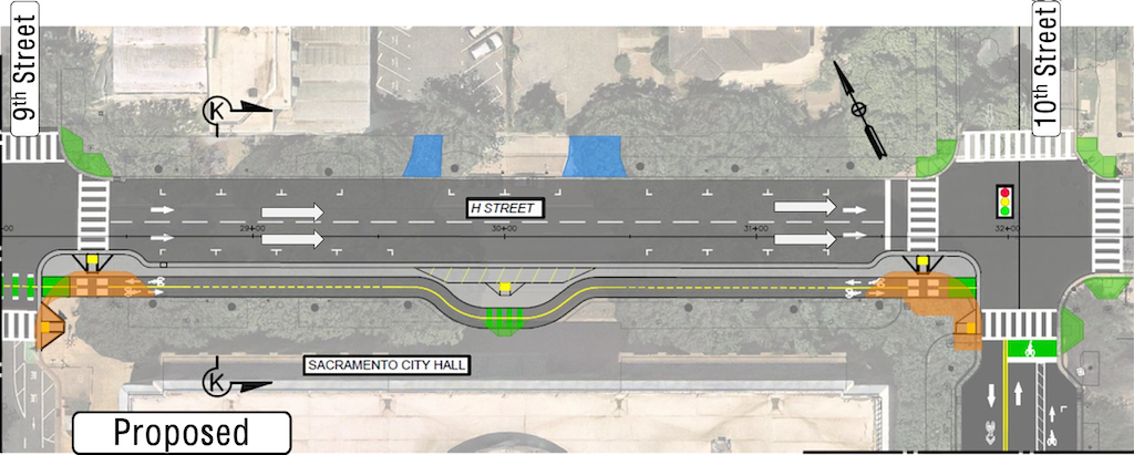
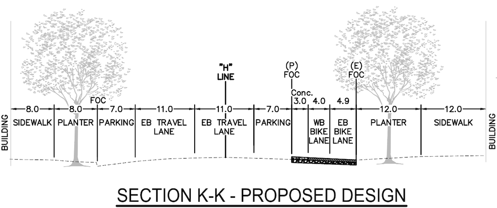
9th Street to 10th Street
I like the design of the segment, a sidewalk level completely separated bikeway.
H St Bikeway from 9th St to 10th St, proposed (from SacATC presentation)
The width of the bikeway is 4.0/4.9 feet (8.9 feet) rather than the minimum of 10 feet. It is not clear how to reallocate roadway width to accomplish this, but it must be done.
H St Bikeway from 9th St to 10th St, proposed cross-section, 87.7 feet ROW?, 47.7 feet FOC (from SacATC staff report)
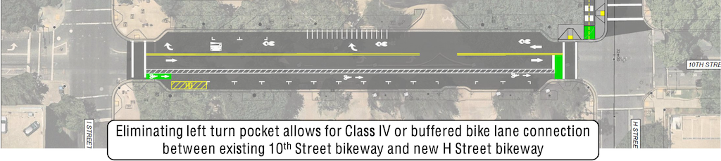
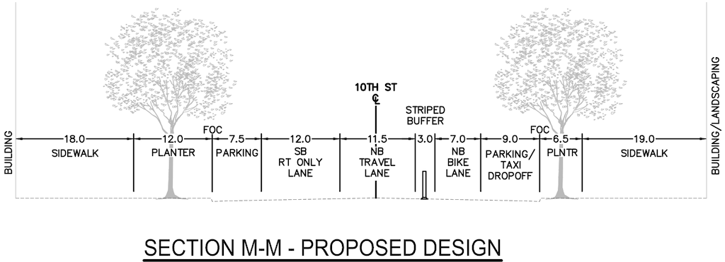
10th Street from I Street to H Street
This segment design is reasonable, given the curb extensions (bulb-outs) present at the bounding intersections. This project probably does not have the funding to reconstruct the street to create a separated bikeway, though this should be done in the long term. A separated bikeway would complete a buffered or separated bikeway on 10th Street all the way from Broadway to H Street. Despite the call-out on the image below, this is just a buffered bike lane, not a Class IV (separated) bikeway. Parking is not needed on both sides, as ample parking is available on nearby streets and in the city parking garage on the southeast corner of I Street and 10th Street.
H St Bikeway, 10th St from I St to H St, proposed (from SacATC presentation)H St Bikeway, 10th St from I St to H St, proposed cross-section, 105.5 foot ROW?, 50 foot FOC (from SacATC staff report)
Signals
The staff report diagrams use the phrase ‘Traffic Signal (Eastbound/Westbound) to be Modified or Replaced’. I am very concerned with ‘replaced’. The city has a penchant for replacing signals, and controller boxes, that do not need to be replaced, raising the cost of projects or wasting money that could be better spent on other parts of the project.
The presentation diagrams show bicycle signal faces at 5th Street and 6th Street, but not 7th Street, 8th Street or 9th Street. Bicycle signals are necessary at every intersection for the safe operation of two-way separated bikeways. It is possible they were neglected on the diagrams, but they cannot be neglected in the project.
Signal timing should be set to a ‘green wave’ of about 13 mph, to allow bicyclists continuous movement through the five blocks. If signal timing remains the same, bicyclists will encounter red light at every intersection, making the bikeway much less useful.
Every pedestrian signal in this section should include a leading pedestrian interval (LPI). Though valuable to enhance transit and bicycling, the design must not disadvantage people walking along or across the corridor.
Speed
The posted speed limit in this section is 25 mph, but observed speeds are higher. This section seems to serve, since the conversion of 5th Street to two-way traffic, as a cut-through from 5th Street to 16th Street, and the design of the intersection of H Street at 16th Street, three dedicated left turn lanes, supports this use. The speed should be reduced to 20 mph, in part to reduce the differential between motor vehicles and bicyclists. Though the bikeway separates these two uses, bicyclists will need to use the general purpose lanes at some points to enter and exit the bikeway, reaching other destinations in addition to the end points. If the posted speed remains 25 mph, and the actual speeds higher, drivers will be encouraged to speed in order to hit green lights. In the central city, many signals are set to 28 mph, encouraging drivers to speed.
Bikeway design
The width of the two-way bikeway in this five block section varies from 8.9 feet (4.0 + 4.9) to 10 feet (5 + 5). The smaller width is not enough to provide safe passage for two larger bikes, such as three-wheel bikes, cargo bikes, and bikes with trailers going in opposite or the same direction. The minimum width throughout must be 10 feet. NACTO’s Urban Bikeway Design Guide says: Two-way bike lanes should be at least 13 ft (3.9m) wide to accommodate all types of bicycles, side-by-side riding, platooning, and passing. A consistent width also allows for bikeway sweeping by devices which cover the full width of the bikeway. The City of Sacramento is deficient is maintaining its existing separated bikeways free of leaves and trash, so future bikeways must be designed for ease of maintenance.
Bikeways should be designed for maximum protection against errant motor vehicles. In blocks without driveways, a concrete curb should be installed, with small gaps for bicyclists to enter and exit. The segment between 8th Street and 9th Street is one such segment. The design with a buffer from parked cars is only effective when parked cars are present. A dedicated motor vehicle right turn lane is adjacent to the bikeway with only a very narrow buffer. The segment from 9th Street to 10th Street seems to have this protection by design. Mountable curbs, as shown for 5th Street to 6th Street may also be appropriate for parts of the 6th Street to 7th Street and 7th Street to 8th Street segments.
NACTO Urban Bikeway Design Guide
The page on ‘Designing Protected Bike Lanes‘ provide guidance on three situations, including two-way (bi-directional) bikeways. The diagram below is from that page. The page includes guidance on dimensions, marking, signs, and intersections.
Other posts on the City of Sacramento Vision Zero Action Plan update are available at category: Vision Zero.
The 2018 Vision Zero Action Plan focused entirely on corridors. It did not identify high injury intersections, nor suggest actions at those intersections, unless they were also part of a high injury corridor.
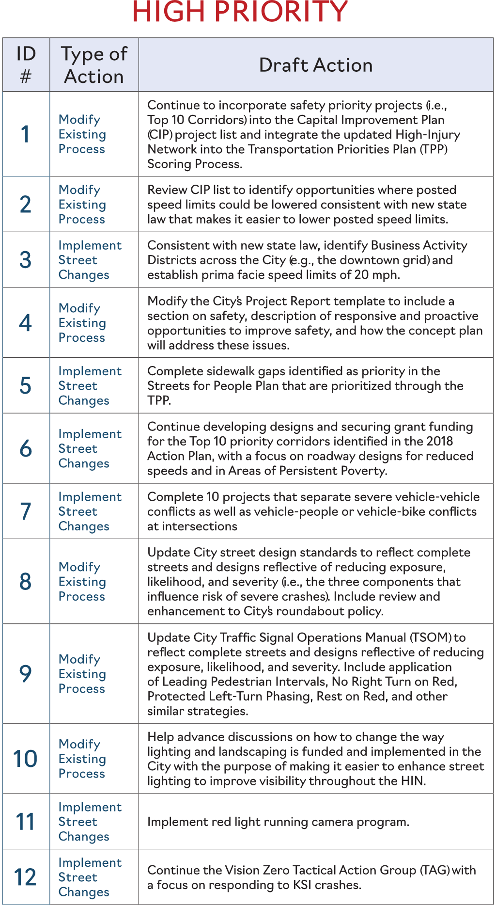
The update does recognize that intersections should be addressed, but at least so far doesn’t focus on them. It should. Element 6 says “Continue developing designs and securing grant funding for the Top 10 priority corridors identified in the 2018 Action Plan, with a focus on roadway designs for reduced speeds and in Areas of Persistent Poverty” which is fairly specific. Element 7 says “Complete 10 projects that separate severe vehicle-vehicle conflicts as well as vehicle-people or vehicle-bike conflicts at intersections” which is rather vague.
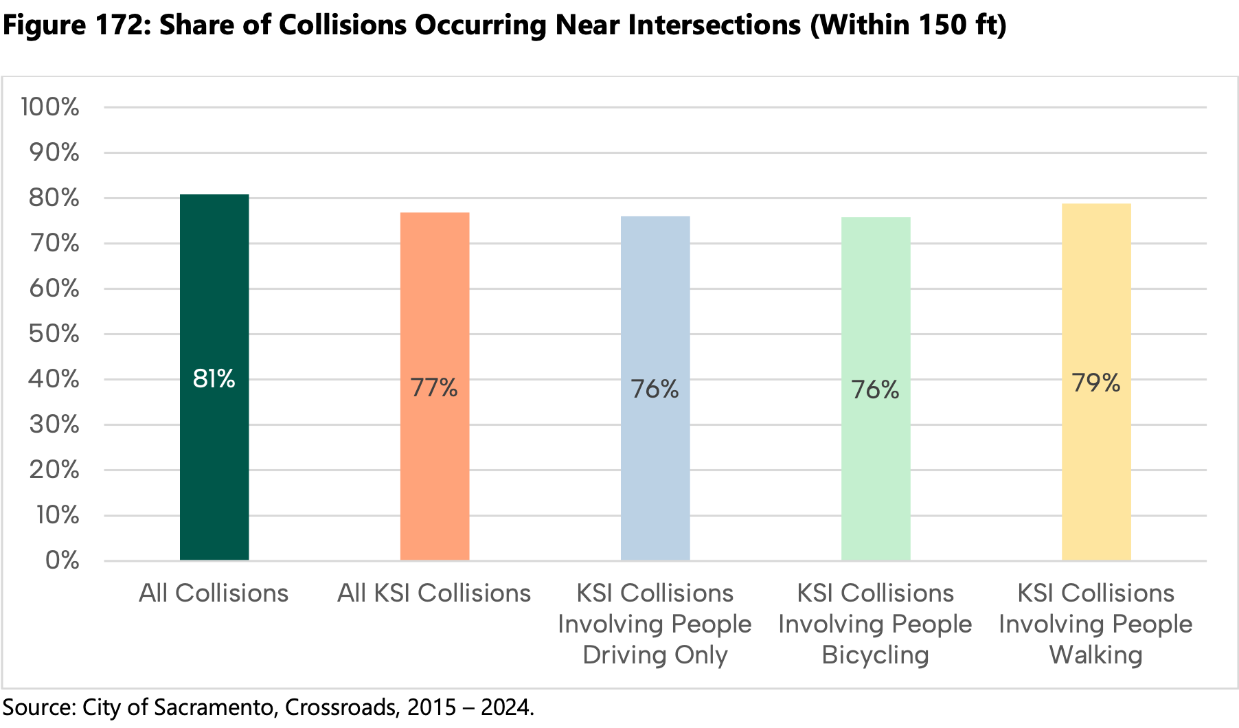
Why are intersections important? Because that is where most of the fatalities occur. Fatality locations are not, and should not, be the only criteria for focus. Serious injuries are also important, and the pattern of these is both more dense and different from fatalities. Actions that prevent fatalities or serious injuries are important.
The map below, an except from the Vision Zero Crash Dashboard Interactive Map, shows only fatalities in the central city (American River to Broadway, Sacramento River to Alhambra). Of the 34 fatal crash locations shown, it appears that five are not at intersections, therefore 29 are at intersections.
This is a visual screen based on the map location of the crashes. The map shows primary road and secondary road for every crash, but does not show distance from the intersection. It would take an analysis of ever crash location to determine for certain whether it is at, near, or away from an intersection.
The only pattern that might be considered a corridor is X Street, the roadway just south of Hwy 50, known to be a high-speed traffic sewer.
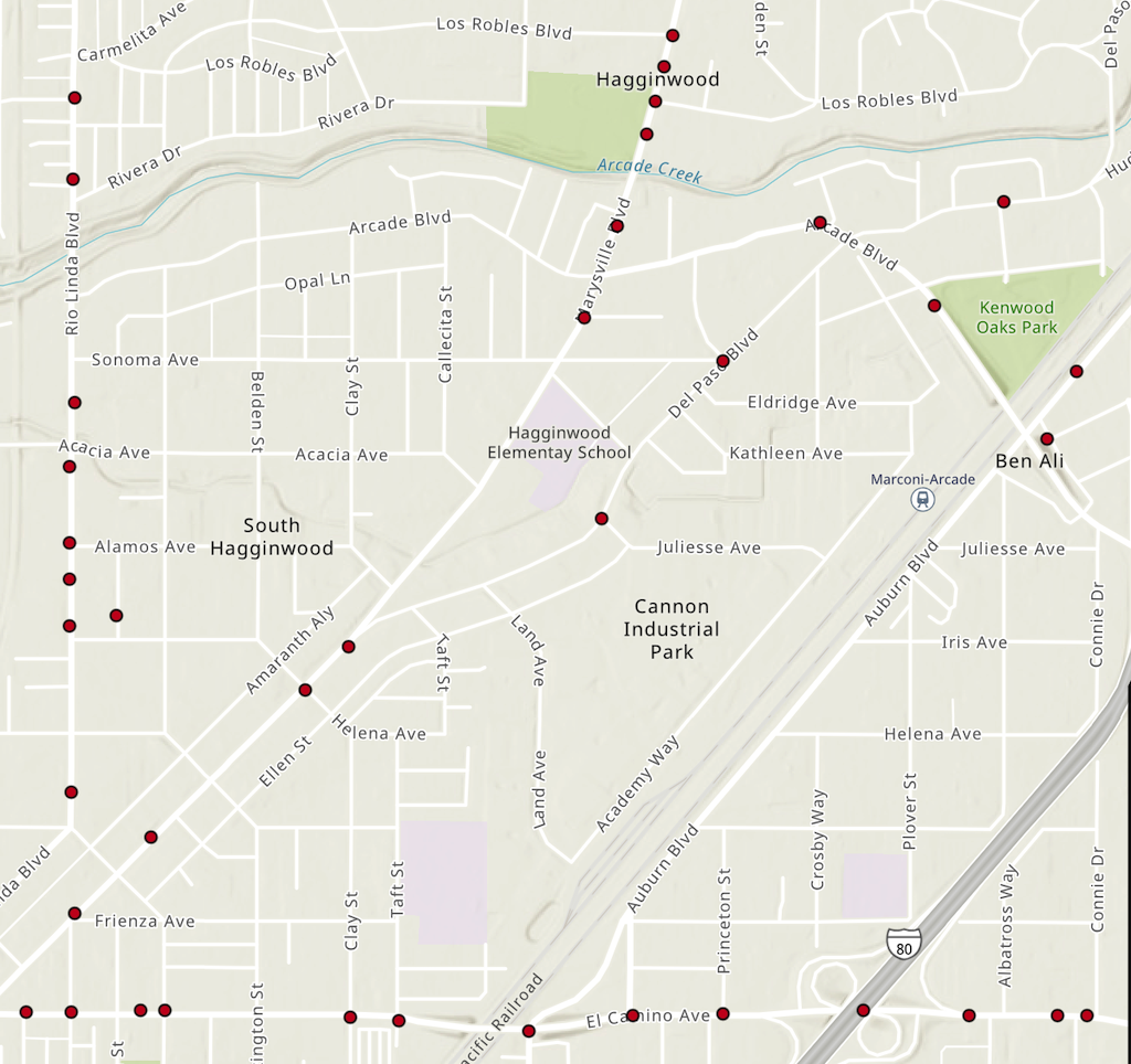
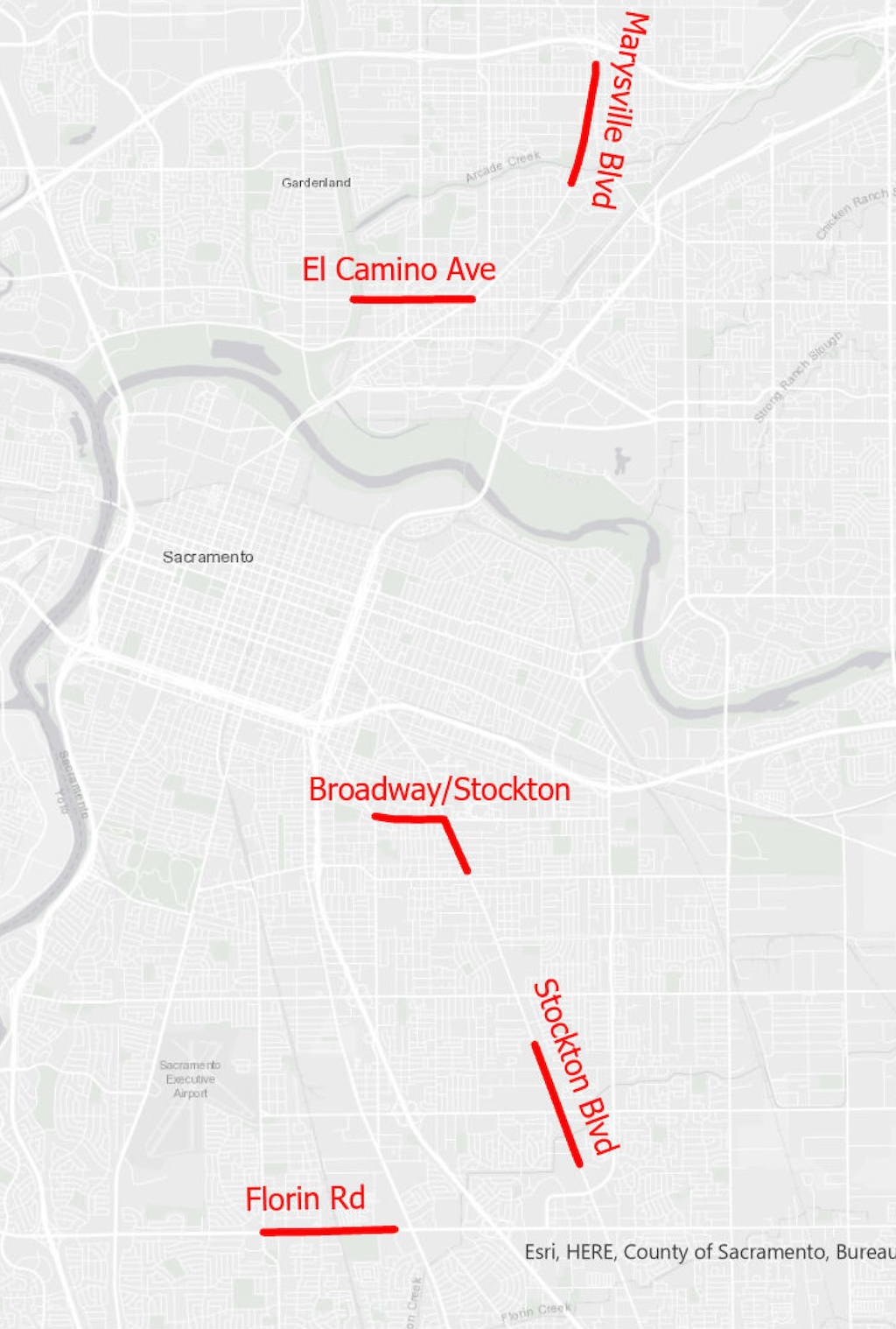
The next maps shows 39 crashes in an area of northeast Sacramento. Of the 39, it appears that 15 are not at intersections, therefore 24 are at or very near intersections.
This is a visual screen based on the map location of the crashes. The map shows primary road and secondary road for every crash, but does not show distance from the intersection. It would take an analysis of ever crash location to determine for certain whether it is at, near, or away from an intersection.
A corridor pattern is more evident on this map. Both El Camino Ave (at the bottom) and Marysville Blvd (middle north) have been identified as high injury corridors.
Other posts on the City of Sacramento Vision Zero Action Plan update are available at category: Vision Zero.
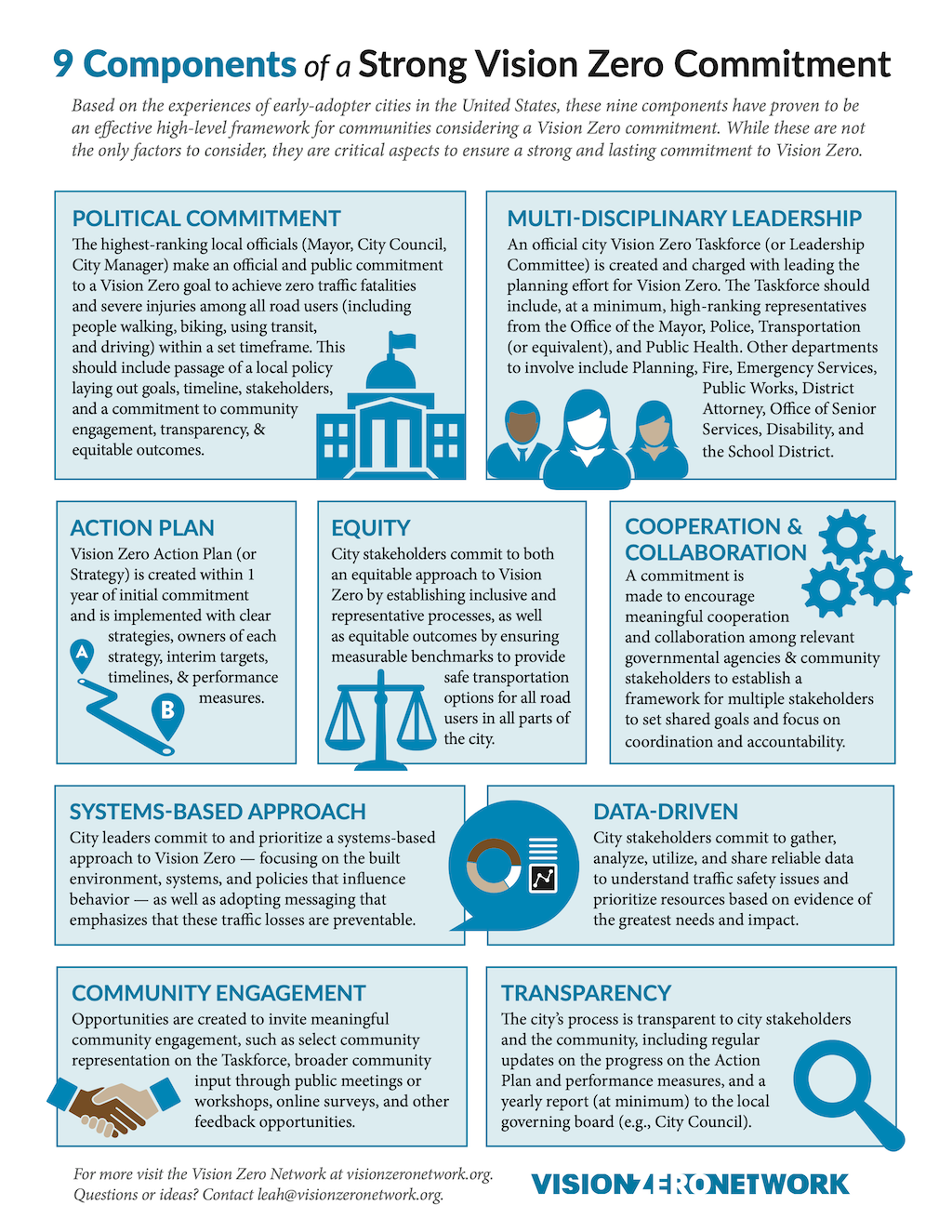
The Vision Zero Network is a national organization which provide leadership and resources for local vision zero efforts.
The organization offers a Resource Library, which has a wealth of documents and references on vision zero. The city’s action plan documents seem to rely on some of these resources, which is a good thing.
One of particular interest to me is a one page chart titled 9 Components of a Strong Vision Zero Commitment, below and pdf. It isn’t just about the action plan, but a strong overall approach.
The City of Sacramento’s Vision Zero Action Plan update will very likely include two elements related to automated enforcement:
#11: Implement red light running camera program.
#25: Support legislation on Automated Speed Enforcement allowances in Sacramento.
The city had automated red light cameras under a program operated by the county, and a private contractor. When the county dropped its program, supposedly because they were not gaining enough income from tickets to pay for the program, the city also dropped its program (the end of red light enforcement). Not confirmed, the cameras may still be installed, though not in use. SB 720 (2025) established new guidelines for red light cameras, which the city will follow in implementing a new program. The Streetsblog California post SB 720 and What You Need to Know about Red Light Cameras, written before passage, is a good summary of the program. Fines are reduced for low-income people, there are provisions for more equitable implementation, and fines may be used for traffic calming.
At this time, the city has no authorization to implement automated speed enforcement, so ‘support legislation’ means supporting adding Sacramento to the list of pilot cities under AB 645 (2023), or creation of a statewide program after the pilot. There are varying opinions about when the state will move to a permanent program, but I remain hopeful.
The advocacy and equity community has long had concerns about bias in in-person law enforcement, and some of these concerns also apply to automated enforcement. Views range from ‘automated enforcement is worth it to save lives’ to ‘automated enforcement must be carefully designed and implemented to prevent bias’. There are a few advocates that don’t believe that an equitable automated enforcement program can be designed, and are opposed until proven otherwise.
Conversations among transportation and equity advocates, and with the city, will continue during development of the Vision Zero Action Plan update.
The best single summary I have found is How To Improve Social Equity in Automated Traffic Enforcement (Elovate, 2024-11). This is a commercial company that sells automated enforcement, but the post seems unbiased. A search for ‘equitable automated enforcement’ will surface many, many articles and posts.
reduction of fines: .“..a designated jurisdiction shall reduce the applicable fines and penalties by 80 percent for indigent persons, and by 50 percent for individuals up to 250 percent above the federal poverty level.” This provision is present in both.
use of fines: “Program costs include, but are not limited to, the construction of traffic-calming measures…” and “Traffic-calming measures” include, but are not limited to, all of the following: (A) Bicycle lanes; (B) Chicanes; (C) Chokers; (D) Curb extensions; (E) Median islands; (F) Raised crosswalks; (G) Road diets; (H) Roundabouts; (I) Speed humps or speed tables; (J) Traffic circles.” This provision is present in both, though the speed camera program also requires that cities implement traffic calming in several situations. The legislation strongly encourages but does not require that income be spent on traffic calming.
relation to existing expenditures: “Jurisdictions shall maintain their existing commitment of local funds for traffic-calming measures…” This provision is present in both, though more restrictive in the speed camera program.
bias reporting: “A racial and economic equity impact analysis, developed in collaboration with local racial justice and economic equity stakeholder groups.” in the speed camera program, and “… jurisdiction shall consult and work collaboratively with relevant local stakeholder organizations, including racial equity, privacy protection, and economic justice groups…” in both. However, it is not clear whether the selection of locations requires analysis of geographic bias beforehand.
My previous posts on Vision Zero cover many topics related to it, and make some recommendations. A draft plan will be available in the spring, at which time I’ll no doubt have many comments. If you haven’t been following the Action Plan update process, this is a good chance to catch up.
This is the first time preliminary plans for creating a safe bikeway on H Street, leading to and from Sacramento Valley Station, have been presented to the public. I will take a closer look and perhaps post again before Thursday.
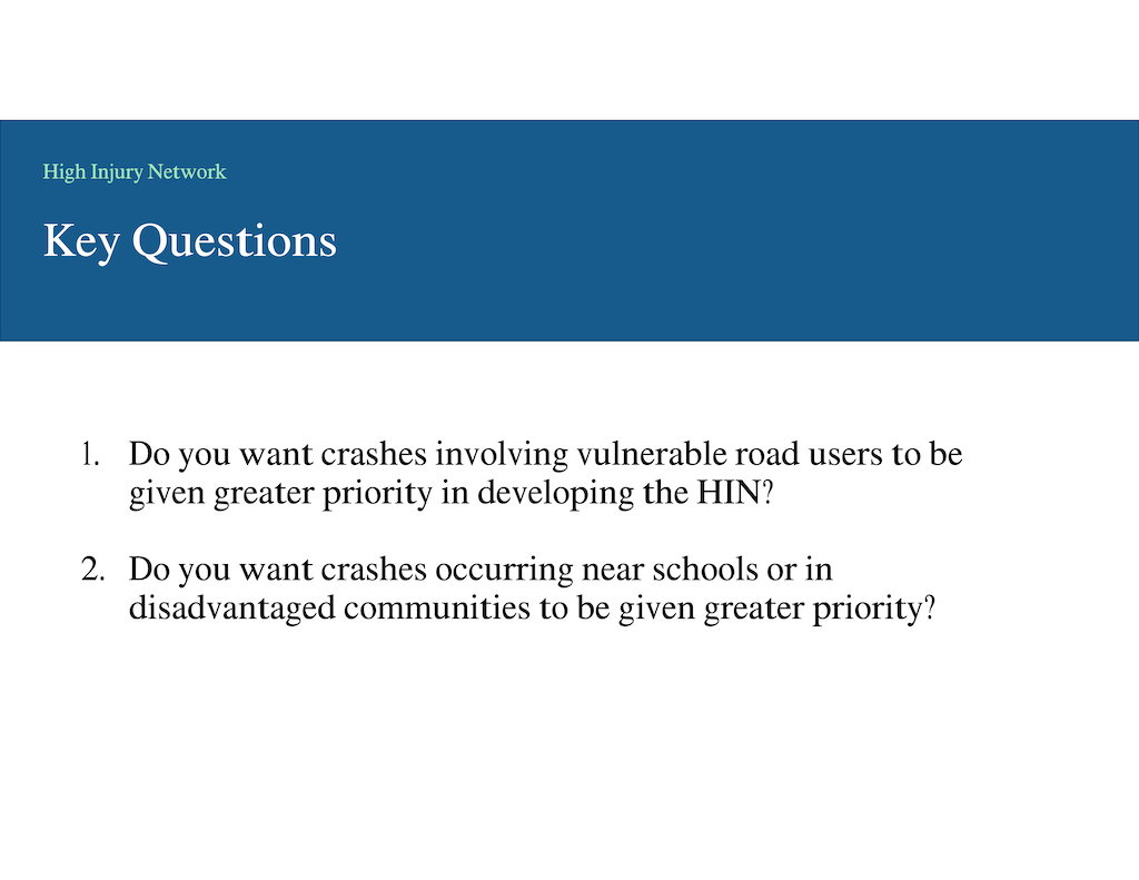
High Injury Network Key Questions, slide from Vision Zero Action Plan update presentation
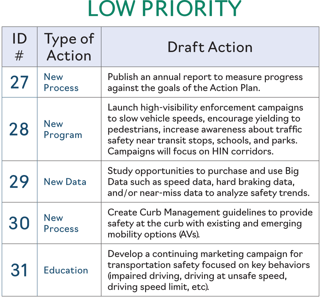
On the Draft Actions sheet, the numbers in the left hand column just reference elements, they do not indicate any priority. The only priorities, on which feedback was being sought, are the three ‘buckets’ of high, medium, and low priority.
The updated plan is intended to cover a span of five years. Where a number of actions are specified within an element, those are over a period of five years, not necessarily evenly distributed.
No information is yet available on prioritization within each bucket.
No information is yet available on sequencing of action elements. Some can be completed in a short time, some will be ongoing throughout the plan time period, and some will not start until later.
The Draft Actions sheet mentions ‘new laws’ in two elements (#2 and #3). References to the legislative bills or state code should be made available.
Element #7 adds intersections to the program, which is great, since the original plan largely ignored intersections in favor of corridors. However, it is not clear what criteria might be used to identify these intersections. The draft High Injury Network continued the focus on corridors, so this intersection element indicates some progress towards considering intersections, which are the location of most crashes.
Crossing guidelines are not part of the plan so far, but could be the location for prohibiting RRFBs (Rapid Rectangular Flashing Beacons), which have proven ineffective in Sacramento. There is an existing Pedestrian Crossing Guidelines document (2021-04), but it isn’t clear how the two documents will relate to each other.
Questions were raised about repaving and pavement condition index (PCI), which is deteriorating in Sacramento (and nearly everywhere). The answer was that there is no clear nexus between pavement and crashes, though obviously there are instances.
Questions were raised about the elements that mention law enforcement (#25 & #28). There is consensus among the stakeholders that in-person law enforcement is too subject to law enforcement bias and escalation, and that automated enforcement must be very carefully implemented to prevent racial, geographic, or income bias.
I asked that an item #32 be added, to make the sidewalk inventory publicly accessible. It is not available on the city’s GIS Open Data Portal, and another person’s PRA (Public Records Act) for sidewalk data did not produce anything useful. See previous post where the streets have no… sidewalks.
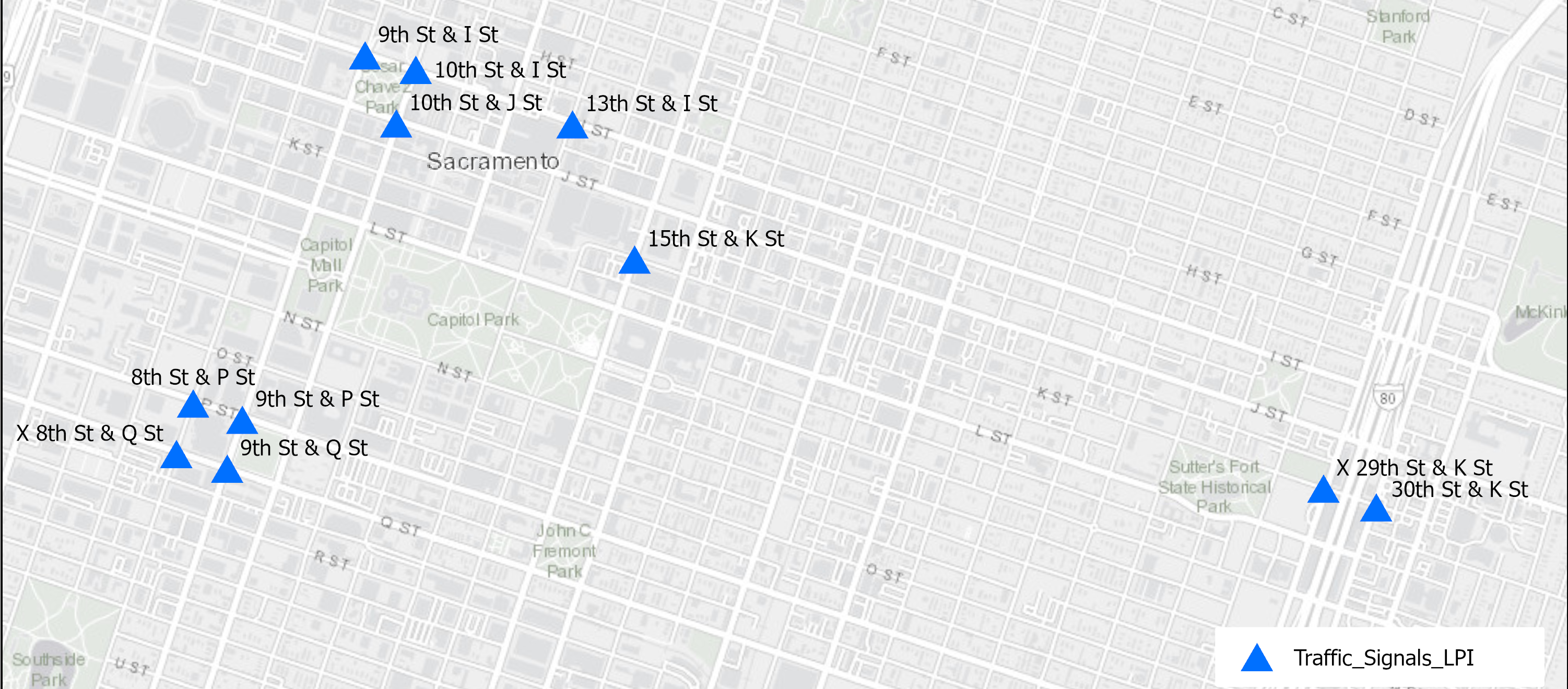
In 2018, I posted a list of leading pedestrian interval (LPI) locations (Leading Pedestrian Interval (LPI) signals), which were provided by the city. Today I field-checked those locations.
Two locations have apparently been removed, 29th & K, and 8th & Q. Six of the locations where I only indicated ‘and’ have LPIs on only one of the cross streets, and I have changed those to ‘at’, 9th at I, I at 10th, J at 10th, I at 13th, 15th at K, and Q at 9th. Three locations have LPIs for both cross streets, 10th & K, 9th & P, and 8th & P.
9th Street at I Street: across 9th only
I Street at 10th Street: across I only
J Street at 10th Street: across J only
I Street at 13th Street: across I only
15th Street at K Street: across 15th only
29th Street and K Street: removed
30th Street and K Street: both directions
9th Street and P Street: both directions
Q Street at 9th Street: across Q only
8th Street and P Street: both directions
8th Street and Q Street: removed
The intersection of J Street at 13th has LPI across J. However, this intersection is unsafe for walkers since the signals allow southbound drivers on 13th Street to turn left across the sidewalk while the walk sign is on. This is the most common vehicle movement, and this is one of the most heavily used crosswalks in the central city since the convention center is on the southeast corner. This must be fixed. I have written before about this intersection (13th & J intersection), but nothing has been improved.
Other intersections of note are
29th Street and K Street which has ‘wave or press’ pedestrian signing, but pedestrian signal is on auto-recall, which it should be.
L Street and 29th Street has no LPIs, but it does have an exclusive pedestrian phase on north leg only.
The Pocket Greenhaven Transportation Plan (2023-11) recommends three LPIs
Florin Rd & Rush River Dr
Greenhaven Dr & Rush River Dr
Pocket Rd & Little River Way
I don’t know the status of this project. It is odd that only three locations were recommended, out of dozens of location with new or modified traffic signals.
If readers know of other locations with leading pedestrian interval (LPI) signals, please comment on this post or email allisondan52@icloud.com.
Previous posts on Leading Pedestrian Interval (LPI), in the City of Sacramento and more generally, at available at tag: LPI.
The Strong SacTown Street Design Standards Working Group has a team working on Leading Pedestrian Intervals (LPI) at traffic signals. If LPI grabs your interest, I encourage you to join the working group. Meetings are posted on Luma, a calendaring application. Go to Luma (app or website: https://luma.com/strongsactown). The next working group group meeting is not listed there yet, but it is normally on the third Sunday of the month at 1:00 PM. Meetings are open to the public; one need not be a member of Strong SacTown or Strong Towns to join in (though you should be!).
The City of Sacramento has a Traffic Signal Operations and Standards page. The prose is garbled, to say the least. The linked documents have nothing to do with operations. It does not include a Traffic Signal Operations Manual (TSOM). Though the plan is supposed to be updated, it is not clear if it even exists.
Streets for People Active Transportation Plan (2025-08, page 105): “An evaluation of best practice to establish guidelines for leading pedestrian intervals (LPIs) at signalized intersections is currently (2025) underway and will be included in the updated City of Sacramento Traffic Signal Operations Manual (TSOM). The TSOM and the guidelines for LPIs will be presented to the Active Transportation and Disability Advisory Commissions to allow for public discussion of the proposed standard practices.”
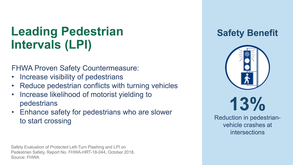
Vision Zero Action Plan Update Safety Improvement Strategies presentation includes the following graphic:
SacCity Vision Zero Action Plan Update, Safety Improvement Strategies, presentation, page 48
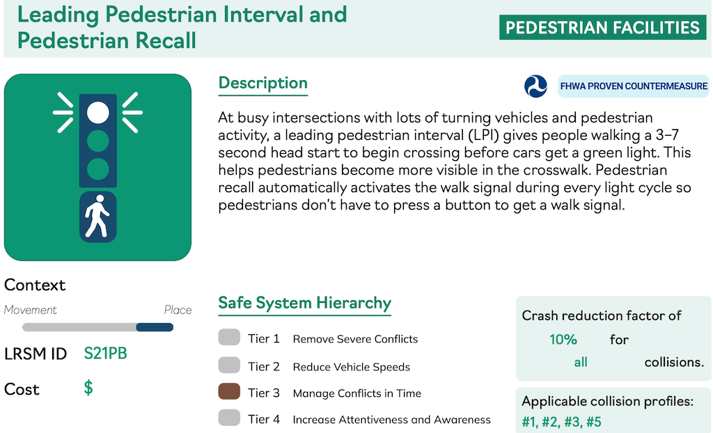
The Vision Zero Action Plan Update Top Collision Profiles and Countermeasures memo includes the following graphic, which has more detail. It is identified as Tier 3, Engineering Countermeasures, Managing conflicts in time.
SacCity Vision Zero Action Plan Update, Top Collision Profiles and Countermeasures, memo, Leading Pedestrian Interval (LPI), page 44
The Vision Zero Action Plan Update draft recommendations includes #9: “Update City Traffic Signal Operations Manual (TSOM) to reflect complete streets and designs reflective of reducing exposure, likelihood, and severity. Include application of Leading Pedestrian Intervals, No Right Turn on Red, Protected Left-Turn Phasing, Rest on Red, and other similar strategies.” Items 19 and 26 might also include LPIs, though they are not called out there.
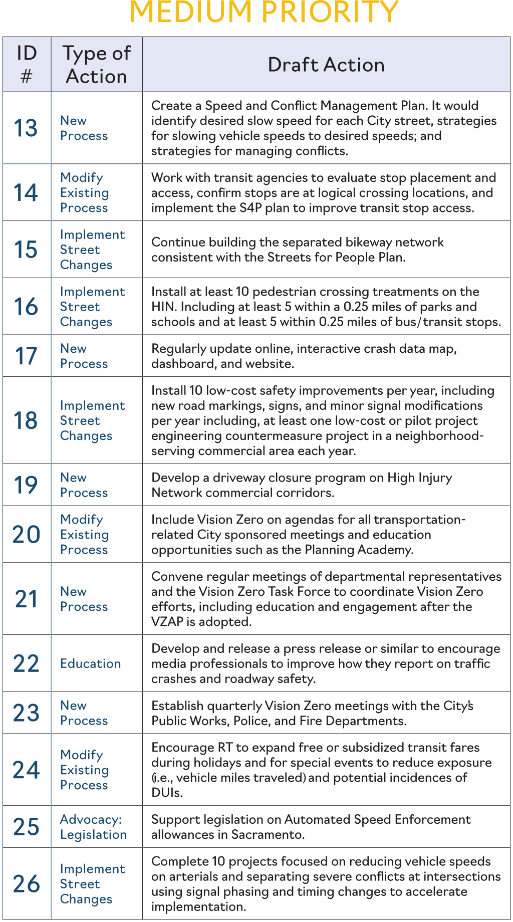
The recent City of Sacramento meetings on the Vision Zero Action Plan update, both virtual and in-person, included slides with draft recommendations for the Action Plan. This same information is also available as a chart (pdf). The three categories, high priority, medium priority, and low priority, are presented below.
Each of these items deserves discussion, and possible movement from one category to another. The one item that I would add to the high priority list, consistent with item 11, is ‘implement speed camera program’ when authorized by state law. I feel strongly, and hopefully, that the state will include Sacramento in the pilot program, and will authorize a permanent program within the span of the Action Plan.