Central City Mobility: 5th St conversion

This is Central City Mobility Project update #6.

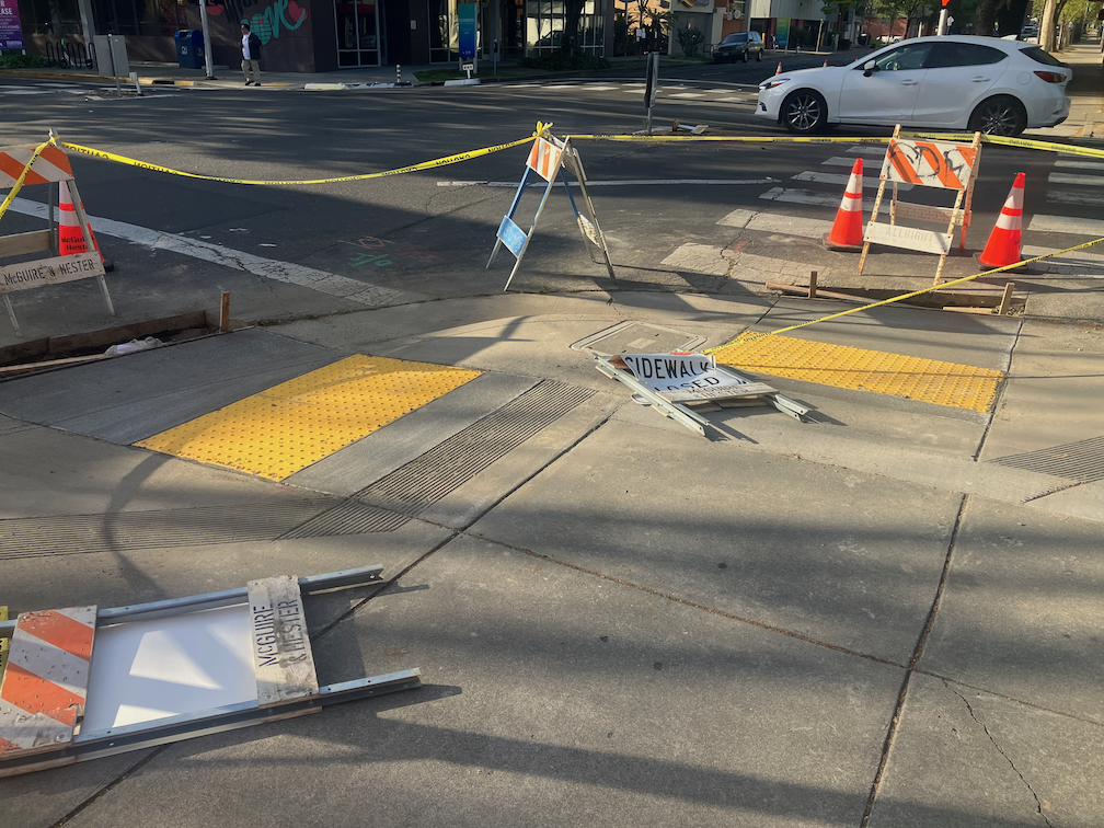
One of the elements of the Central City Mobility Project is the conversion of 5th Street from a one-way, two-lane street, to a two-way, one-lane each direction street. Some work is underway: wiring and signal bases have been installed for the signals necessary for two way traffic at the existing signal locations. Looking at the bases, photo below, I’m guessing that there will be new signal poles and mast arms, not re-use of the existing signals equipment. That seems like a waste of money to me, but the city loves to spend money on new signals, and signal controllers.

I am not sure that many of the current signal locations are even needed. After the conversion, 5th Street will be a lower speed and probably lower volume street. Four-way stops at some major cross streets (such as T Street) might work just fine. Again, the city loves to spend money on signals, and already has unneeded signals at a number of locations (too many traffic signals?).

5th St and T St new signal base

The Central City Mobility Project map shows the 5th Street conversion as extending from Broadway to I Street. The block between Broadway and X Street is already two-way, as are the two blocks between L Street and J Street (the DOCO underpass). It is also two-way north of I Street.

I wonder what, if anything, will be done for the block between X Street and W Street, under the Hwy 50 freeway. This is a very complex block, with a freeway onramp west of 5th Street and a freeway offramp west of 5th Street. The onramp and off-ramp have separate signal phases from X Street and W Street. Traffic westbound onto the ramp, if it makes the green light, is already traveling at freeway speeds, about 65 mph as it crosses 5th Street. Similarly, but not as egregious, the off-ramp traffic, if it makes the green light, is traveling a bit below freeway speeds. I am really not sure how this complex situation can be made safe for bicyclists. Northbound bicyclists only have to deal with drivers running the red light at 5th Street from W Street, but southbound bicyclists would have to deal with multiple turning vehicle movements. In general, the only way to make complex situations like this safe is to have exclusive bicycle phases in which only bicyclists and walkers are moving, no vehicle movement or turns are permitted. But the city is very unlikely to select that safe alternative because it would lengthen the signal cycles and therefore slow motor vehicle traffic to some degree. The city doesn’t want to slow motor vehicle traffic.

The diagram below, from Google Maps, indicates the complexity of this block, but the reality on the ground is even worse.

Google Maps of 5th St and Hwy 50 intersection

the importance of I Street

I have written before about the two one-block sections of I Street where the bike lane is replaced by sparrows. I won’t repeat here, but please read why are bike lane gaps so important?, Sacramento’s worst possible place for sharrows, Sac kill those sharrows on I St.

So the neglect of the Central City Mobility Project for fixing these two blocks of I Street is disturbing. Of the people riding on I Street anywhere west of 16 Street, probably 50% are going to Sacramento Valley Station. But if you spend time on I Street looking for bicyclists, you won’t see many. The average bicyclist won’t ride on I Street. They are uncomfortable with the volume and speed of motor vehicle traffic, but more importantly, they are scared to death of these two one-block sections with only sharrows. So they drive to, or have someone drop them off at, the station. Sacramento Valley Station is the most important transit hub in the city, in the county, and in Northern California outside of the Bay Area, yet the city has neglected access to the station.

The TIRCP grant for improvements at Sacramento Valley Station may improve access from the station on H Street, but again, that is not a near term project, and it is not clear how effective it will be. Probably 80% of the riders on H Street are coming from the station. (Sac kill those sharrows on H St, H St bicycle fixes)

My observation of bicyclist numbers and destinations is based on observation and talking to some riders. It would be nice if the data were available, but I don’t have it, and apparently the city doesn’t have it, or at least has never shared it publicly. I know that the city purchased cell phone data several years ago that would have allowed them to see bicyclist patterns, but so far as I know, they only used it for motor vehicle drivers patterns.

I St shadows between 10th St and 9th St, Sacramento

more Central City Mobility Project

This is Central City Mobility Project update #5.

The City of Sacramento’s Central City Mobility Project is underway, and projected to finish by next May. The map below shows the major components of the project: new parking protected separated bikeways on 19th Street and 21st Street between W Street and I Street, extended parking protected separated bikeways on P Street and Q Street from 15th Street to 21st Street, a separated bikeway (not parking protected?) on I Street from 21st Street to 12th Street, and conversion of 5th Street from a one-way street to two-way from Broadway to I Street (the two-block section from L Street to J Street is already two-way). The project also includes upgrades of corner ramps to ADA compliance along 21St, 19th, P, Q and I streets. I notice that ramp upgrades are also occurring at some locations other than these streets, whether under this project or a separate initiative, I’m not sure.

Central City Mobility Project map

As far as it goes, this project looks to be great. The city is making an effort to create a grid of higher quality bicycle facilities in the central city, of a mile spacing, or less. But a bicycle network is only as good as it’s weakest spot, and this project leaves several weak spots in the grid. The map below highlights some of these, shown in cyan color:

  • P Street and Q Street parking protected separated bikeways should be extended west to 5th Street, which would include a reduction of lanes on those streets. Stopping the bikeways at 9th and 10th Street reduces access to Sacramento Valley Station, as well as many other destinations in this area, including using the Tower Bridge to access West Sacramento.
  • 9th Street parking protected separated bikeways should be extended from Q Street south to Broadway, to provide access to the higher quality bikeway along Broadway, and points south of Broadway.
  • I Street separated bikeway should be extended from 12th Street west to 5th Street, created a complete bikeway from 21st Street to Sacramento Valley Station.
  • J Street parking protected separated bikeway should be extended east from 5th Street to 19th Street, to proved a complete bikeway from 5th Street to 28th Street.
  • A separated bikeway should be constructed on 28th Street to provide a high quality bike route parallel to the unsafe 29th Street one-way southbound traffic sewer and 30th Street one-way northbound traffic sewer.
  • Regular bike lanes, at a minimum, should be installed on 13th Street between P Street and Capitol Park. 13th Street is one of the most heavily bicycled north-south routes in the entire central city, but this two block gap makes that trip less safe.

It is also possible that the P Street and Q Street bikeways should be extended east at least to 28th Street, or beyond, but I haven’t looked closely at that yet.

Central City Mobility Project map with recommended additions
Read More »

Central City Mobility update

This is Central City Mobility Project update #4.

The repaving of 21st Street between W Street and I Street is complete. The section has been marked with ‘temporary road marker tabs’ (these have various names). The marking is for parking lanes on both sides, of eight to ten feet, and ultra-wide general purpose travel lanes, of at least 16 feet. No bike lanes were marked, though the street previously had marked bike lanes. A typical move on the part of the city and its contractors, to take care of motor vehicle travel and parking, but forget about bicyclists. This is of course temporary, but state and federal law require accommodation of bicyclists in construction zones. No such accommodations was made.

21st St between J St and I St, ultra-wide travel lanes, parking lanes, NO bike lanes

There are temporary paint markings for the first several blocks north of W Street, showing what the paint configuration will be. The parking protected separated bikeway is, as was likely, on the left side because most of this stretch has bus service on the right. The bike area is about seven feet wide. The buffer strip of about three feet wide, and the parking lane is about eight feet wide. The buffer may or may have vertical delineators (soft hit posts) continuously or at conflict points. There is no indication at any location, so far, that there will be hard curbs to actually protect bicyclists when parked cars are not present. For information on why a seven foot bikeway is not sufficient, please see bike lane widths. NACTO recommends at least eight feet.

21st St temporary marking for separated bikeway

As I rode up 21st Street, I noticed that the bus stop is marked in the same way that the parking lane is. I hope this is just a temporary mistake, otherwise there will be parking in the bus stop despite the red curb. The city is still failing to do two things it can to better support transit: 1) install concrete bus pads so that the weight of the bus at the stops does not distort the pavement and cause potholes, and 2) paint the pavement red at each bus stop so as to make it clear that this is a place for buses only, and not private vehicles. And, yes, it would be nice if transit islands were installed so that the bus does not need to pull out of and then into traffic. The city keeps saying that it supports transit, but doesn’t actual do anything to support transit.

21st St bus stop, marked as though it were a parking lane

Lastly, in the category of ‘be careful what you wish for’… I had wondered why the city was not taking advantage of the ADA ramp project to put in curb extensions (bulb-outs) at some critical intersections for walker safety. This afternoon, I noticed that they are putting in curb extensions on the northeast and southeast corner of 19th Street and O Street. Yay? Nay? The problem is that the location of the extensions would extend into the separated bikeway on the left side of 19th Street southbound. The photo below, looking north along 19th Street at O Street, shows the extension under construction. There is supposed to be a curb-adjacent, parking protected separated bikeway here. I assume that bus stops for SacRT Route 62 southbound will be on the right hand side of the street, and the separated bikeway on the left hand side. Is there anyone paying attention? Anyone? Ferris? Anyone?

update on SacCity ADA ramps

Note: I discovered that I have often used ‘detectible’, but should have been using ‘dectectable’ for detectable warning strips.

This is Central City Mobility Project update #2.

This is an update to the update on work being done on corner ADA ramps in the Sacramento central city, apparently as part of the Central City Mobility Project.

So far as I have seen, curb extensions are not part of this project.

There are now a number of locations where the concrete ramp is being cut so that the detectable warning strip can be installed, but the curbs are not being touched. See below for an example.

Q-St & 16th-St, SW corner, ADA ramp construction

One of the corners I have been monitoring, 21st St and O St northeast corner, is complete, but with temporary patches that make the ramps useable, though ironically still blocked by folding barricades and caution tape, which absolutely does not meet ADA guidelines for contruction signing and safety. This seems to be the pattern with the city, trying to make things better, but not paying attenteion to the details. I don’t know when the asphalt will be restored and the corner opened. Maybe the contractor is waiting until all the corners are ready before patching, though that would be stupid.

21st-St & O-St, NE corner, completed corner with ADA ramps

I am still not able to make sense of the asphalt cuts that are being done on the corners where the curb will be or has been modified. I’m guess that there was a standard cut design, implemented everywhere, no matter what the actual project.

Walking around the central city, it appear that most of the corners which did not have ADA-compliant ramps will have them when the project is done, but some may not. I don’t know what the criteria is for which corners are being done, and which are being done at a higher level of replacing the curbs and widening the ramps. Many of the existing ramps are narrow, with edging curbs, which was apparently the design at the time they were placed, but the new corners are a different design, with a sloping area between the two ramps, similar to the diagram below, from the 2020 Department of Utilities Standard Specifications: Transportation drawings, not from the 2009 Department of Public Works Street Design Standards, which contain no ADA diagrams. I think the detectable warning strip width is at least 60 inches on the new installations, which is an improvement. The 48 inch width does not allow two people to stand on the strip. Corners with new curb extensions seem to have 72 inch strips.

SacCity T-76 Curb Ramp Dual Combination Planter diagram
SacCity_T-76_CurbRampDualCombinationPlanter

update on half-measure corners

This is Central City Mobility Project update #1.

There has been construction on several of the corners I had previously mentioned (half-measure corners?), with 21st Street and O Street being the most advanced. It seems that I was wrong about curb islands being put in – there is no evidence of such construction. I don’t know why the asphalt cutting implied that. When more of these are complete, I’ll post again.

What seems to be going on is simple updates to place ADA-compliant curb ramp with detectable warning strips. Of course any improvement to curb ramps helps everyone, disabled and otherwise, and I’m not criticizing that. Rather, wondering why when the city is changing these corners, they did not take the opportunity to do true curb extensions. The ADA ramp and detectable warning in place for O Street is wider, than previous ramps and strips, looks to be more than four feet rather than the prior narrow ones. If all the ramps end up wider, that will be a plus.

This work is probably part of the city’s Central City Mobility Project. The project detail mentions ‘turn wedges’. Maybe the wedges will be added later, or maybe these will be at different locations than the ones I’ve looked at. The page does not specifically mention ADA ramp improvements.

21st St & O St, northeast corner, ADA ramp construction, partially complete

I had mentioned in the previous post curb extensions being extended to serve as bus boarding areas. I am not aware of any of these in Sacramento, but San Francisco has many. Many earlier posts have mentioned bus boarding islands, but this is for a street without bike lanes (yet), which allows the bus to stop in-lane and people to board directly. Notice that the extension allows for a bus shelter without constraining the sidewalk width for walkers. This should be the standard for Sacramento for all streets with bus routes but not bike lanes.

curb extension and bus boarding extension, San Francisco, Leavenworth & Sutter

half-measure corners?

Summary: The city should not install curb islands at corners, as it is currently doing, but rather install much safer and more effective true curb extensions, even if fewer can be installed now. Temporary installations can be used at other corners.

The City of Sacramento is currently re-doing a number of intersection corners in midtown. Most of these corners are along 21st Street, so far as I’ve noticed, but some are on other streets, and there well may be other locations I’ve not noticed yet. Last week crews were out saw cutting asphalt at corners, in preparation for new concrete work. The existing corner concrete and ramps have been removed from at least two corners, and at the 21St Street and O Street corner there is form work for whatever is going to replace the old corners.

The first photo is of the saw cuts at P Street & 19th Street. The cuts don’t really stand out, but they do indicate the areas that will be changed.

19th St & P St, SW corner, asphalt cuts for corners changes

It appears from the saw cuts that what is going to be constructed is something similar to the existing northwest and northeast corners. Northwest is shown below. I am not sure what to call these. They are not in the city’s street design standards, and almost the only place where I’ve seen them is Sacramento. I looked at several other cities to see if these were in their street designs, and they were not. So, just to call them something, I’m going to call them ‘curb islands’. The City of Los Angeles calls these floating curb extensions, but apparently their intended use is with bike lanes, not with gutters.

19th St & P St, northwest corner, corner islands
Read More »