SacCity separated bikeway failure?

Are the City of Sacramento separated bikeways on 9th St, 10th St, 19th St, 21st St, J St, P St and Q St a failure?

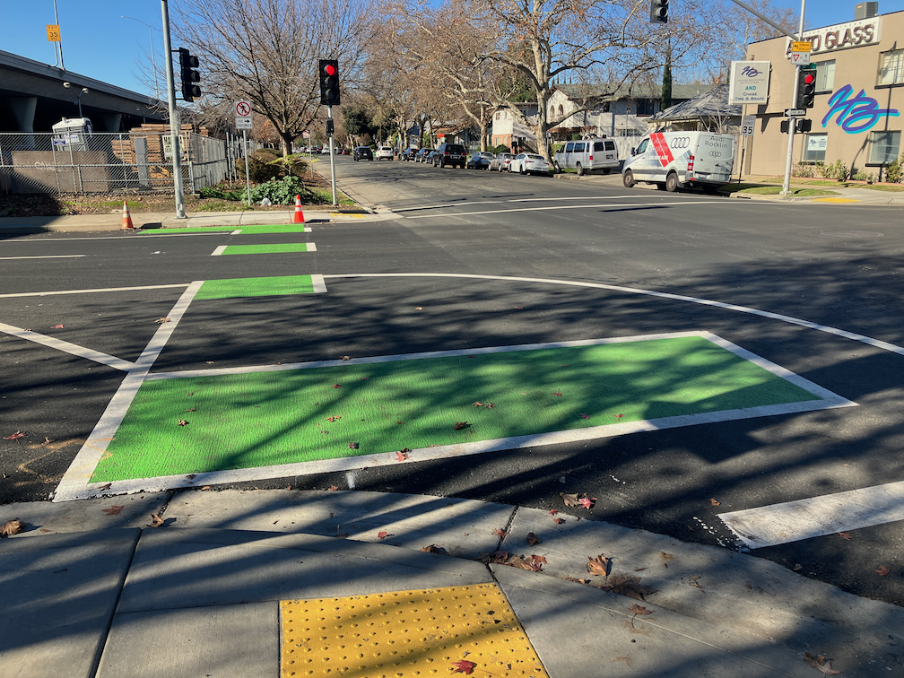
These separated bikeways are mostly but not entirely parking protected, meaning they are between the curb and the parking lane. The city purchased a bikeway sweeper specifically for use on these bikeways. But that sweeper has not been used this year. As documented in SacCity is not sweeping separated bikeways, the bikeways are filling with fallen leaves, which have now turned to leaf slime. Though I have not seen anyone fall on the leaf slime, I’d not be surprised, and I have slipped but not fallen several times. Some of the bikeways have been cleared, but it has been by adjacent property owners, and by City of Sacramento Youth, Parks, and Community Engagement (YPCE, otherwise called parks) on some but not all park-adjacent blocks. City of Sacramento Public Works, whose responsibility it is to sweep these bikeways which are part of the transportation system, have done nothing. Nothing.

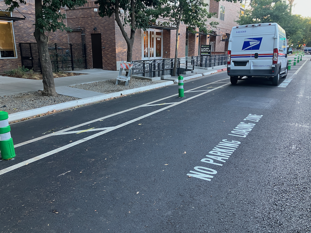
A second issue is that the city has done nothing to solve the bikeway blocking that occurs on a daily basis on P Street approaching 16th Street. The bikeway here is blocked by delivery vehicles, people moving in and out of the adjacent residences, and people picking up food from the restaurants. The city is very aware of this problem, as there are frequent reports to 311 of illegally parked vehicles, by myself and many other bicyclists. But nothing has been done to solve the problem. This location needs, at the least, additional vertical delineators to discourage drivers from using the bikeway, and even better, a hard curb to prevent use.

It is worth noting that there is marked loading zone immediately adjacent to the bikeway, see below. Most drivers choose not to use that, or it is routinely blocked by drivers parked for a long period of time, clearly not loading.

photo of loading zone adjacent to bikeway, P St
loading zone adjacent to bikeway, P St

There are other locations where a separated bikeway is blocked by motor vehicles, but nowhere is it as common as the P St approaching 16 St location.

If the city is not willing to maintain the bikeways, and is not willing to solve issues with the bikeways of which it is very aware, then it can’t claim these as separated bikeways. Maybe they should be removed.

On the plus side, the city’s 311 app finally includes a drop down for ‘blocking bike lane’ under the parking violations menu, about five years after the request being made by myself and many others.

Central City Mobility Project update: 5th Street conversion

This is Central City Mobility Project update #35.

I noticed over a week ago that all striping has been removed from 5th Street, including crosswalks, so had presumed that the conversion from one-way to two-way was immanent. Nope. Nothing has happened since then. I guess the city thinks it is OK to remove striping from a street and then do nothing. In a sense, it might be OK, because drivers, without striping to guide them, will be uncertain, and slow down. Maybe.

photo of erased crosswalk on 5th St
erased crosswalk on 5th St

21st St bikeway issue at W St

Note: This post is not about the bicyclist fatality that occurred in this area recently. Not enough is known about that to post, yet. This is Central City Mobility Project update #34.

There is an issue with the 21st Street separated bikeway at W Street. The northbound bikeway transitions from the east side of 21st Street to the west side of 21st Street at W Street. There is a two-stage turn box on the northeast corner, intended for bicyclists who have crossed W Street on the green light to wait to cross 21st Street on the green light, to access the separated bikeway on the west side of 21st Street. The photo below shows the box being used by a walking bicyclist, who waited in the box. The signal has turned green and he has started to cross. A right-turning driver from W Street to 21st Street stopped suddenly to avoid hitting the bicyclist/pedestrian, because the driver did not expect to see someone there. The vegetation somewhat but not completely obscures someone in the box.

photo of 21st St at W St NE two stage turn box with bicyclist in box
21st St at W St NE two stage turn box with bicyclist in box

The city has placed a ‘no turn on red’ sign on W Street, photo below. In about 40 minutes of observation, 60% of the drivers who could turn, meaning they were not blocked by a vehicle in front of them, did turn on red. This is the time when the box would be occupied by a bicyclist.

photo of W St 'no turn on red' sign to 21st St
W St ‘no turn on red’ sign to 21st St

On the green light, drivers are taking the right turn at high speed. If there were a bicyclist or a walker crossing 21st Street, here, it is doubtful that many drivers would notice the person and brake in time. This is a severe injury or fatality waiting to happen. The video below shows drivers cutting across the two-stage turn box.

video of drivers cutting across the two-stage turn box on 21st St

Solution

A temporary solution is to install vertical delineators (flex posts) to block off the right hand lane of W Street approaching the intersection. There is a short section of red curb here, where the ‘no turn on red’ sign is, but the blocked off area should extend 20 feet up to the crosswalk, and be the width of the parking lane. A green K-71 vertical delineator, or two, should be placed at the southwest corner of the two-stage turn box, to force drivers to go around the turn box, and also slow turning movements. The diagram below indicates possible locations of vertical delineators, white dots. Base excerpted from CCMP plans.

diagram of 21st St at W St NE corner, vertical delineators to slow and control vehicles

A more permanent solution would be to reconfigure the northeast corner to add concrete barrier protection for the turn box. The city, having enticed bicyclists to this location, owes them a much higher level of protection that is currently offered.

Central City Mobility: new beg buttons on 5th Street

This is Central City Mobility Project update #33. Note that 5th Street has not yet been converted from one-way to two-way.

When looking at 5th Street, part of the Central City Mobility Project to convert this from a one-way street to a two-way street, I was focused on the looking at the new signals and the mast arms. I failed to notice all the new beg buttons that have been installed. These are the ‘wave at’ variety. Installations are at Q Street, P Street, N Street and Capitol Mall. At Q, P, and N Streets, there are 8 new buttons per intersection. At Capitol Mall there are six, all on the east side of the intersection, because there is a pedestrian crossing prohibition on the west side. I don’t have documentation of what was here before these were installed, but I’m pretty sure that these intersections were on auto-recall, meaning that the button did not need to be pressed, or waved at. I have to admit I have been fooled again by City of Sacramento Public Works. I had been assuming that either things would remain the same, or things would get better. They have proved me wrong by making things worse.

photo of 5th St & Q St SE new wave beg button
5th St & Q St SE new wave beg button

There are beg button posts installed at R Street as well, but since this crossing of 5th St has not been activated, I don’t know how the beg buttons will be labeled.

Read More »

Central City Mobility update: 19th Street

This is Central City Mobility Project update #32.

The 19th Street bikeway has been completed from W Street to Broadway. Only a half block of the two blocks is separated bikeway, and it is on the right side rather than left side as it is to the north. At W Street there is a bike box in line with the bikeway to the north, and a green dashed bikeway to carry the bikeway from the left or east side to the right or west side. The curved area shown in the photo does not have any sort of protection to reduce turn speeds, as is present on most turn wedges in the rest of the Central City Mobility Project.

The turn intersection involves a two stage turn for bicyclists, once to cross W Street to the south side, and then to cross 19th Street to the west side. There is no separate bicycle phase or bicycle signal face here. The pedestrian crossing phohibition here and lack of crosswalk indicates two things: there is no sidewalk on the south or freeway side of W Street, and that high speed turns from W Street to 19th Street are expected and encouraged. This project would have been a great time to add a crosswalk and pedestrian signaling here, and remove the prohibition, as both sides of 19th Street under the freeway have sidewalks, so a crosswalk would speed travel for walkers by offering two routes of travel. Bicyclists using the green dashed crossing of 19th Street have turning traffic at their back, which is somewhat unsafe but could have been made safer with an exclusive bicyclist phase or even a bicyclist signal phase. Since the signal timing favors W Street over 19th Street, it could have been possible to allow both a brief bicyclist phase and a turning phase.

photo of 19th St bikeway transition to right side
19th St bikeway transition to right side

Crossing under the freeway, the bikeway is partly green painted and next to a travel lane, and partly parking protected bikeway to X Street. From X Street to Broadway, it is a regular door-zone bike lane. At Broadway, there a green bike box the full width of the street, allowing bicyclists to continue straight or turn left onto Broadway.

To summarize, the design is OK but could have been better.

Central City Mobility: 21st & I bike signals

This is Central City Mobility Project update #31.

The bike signals and related signaling is now installed at the intersection of 21st Street and I Street, where the northbound 21st Street separated bikeway ends, and the westbound I Street separated bikeway begins. East of this intersection, I Street is two-way. The I Street bikeway is on the north side, right side, so bicyclists must transition from the southwest corner to the northwest corner. Bicyclists continuing north on 21st Street must also transition from the left side bikeway to the right side general purpose lane.

The city has attempted to solve this problem by installing bicycle signal faces on the northwest corner, for bicyclists turning left on I Street, and the northeast corner, for bicyclists going straight on 21st Street. The photos below show the northwest corner bicycle signal green and turn arrow red, bicycle signal red and turn arrow green, and the bike signal on the northeast corner.

photo of 21st & I St, bicycle signal green and turn arrow red
21st & I St, bicycle signal green and turn arrow red
photo of 21st St & I St, bicycle signal red and turn arrow green
21st St & I St, bicycle signal red and turn arrow green
photo of 21st & I St, bike signal on the northeast corner
21st & I St, bike signal on the northeast corner

The signals are set up so that bicyclists, and walkers on the west leg of the intersection, have an exclusive phase, meaning that no cars are supposed to be moving when the pedestrian signal shows walk, or the bike signal is green. Actually, triggering the bike signal also triggers the pedestrian signal, and vice versa, they are ganged together.

The problem is that drivers are turning left from 21st Street to I Street against the red arrow, endangering bicyclists going west and north, and walkers in the crosswalk. In about 30 minutes of observation over the last few days, I saw drivers turning left against the red about half of all signal cycles. Once the front driver decides to turn, all other drivers follow. I did not see any drivers turning from the right hand left-turn-straight lane.

California Vehicle Code (CVC) 21453 says: (c) A driver facing a steady red arrow signal shall not enter the intersection to make the movement indicated by the arrow and, unless entering the intersection to make a movement permitted by another signal, shall stop at a clearly marked limit line, but if none, before entering the crosswalk on the near side of the intersection, or if none, then before entering the intersection, and shall remain stopped until an indication permitting movement is shown.

So, every single one of the drivers who turned left on the red arrow was breaking the law. Sadly, the city has designed an intersection that assumes drivers will not break the law, but as every bicyclist and walker knows, drivers do so pretty much continuously. I do not know what the solution is for this intersection. It is difficult to control driver behavior. In any other situation than roadways, the behavior of routinely breaking the law is called lawlessness.

Signal actuation (beg buttons)

In addition to the new signals, there are signal actuators, generally called beg buttons. Nothing here is on auto-recall, meaning there is not a bicyclist and pedestrian phase on every signal cycle, but only when requested.

The actuator for the pedestrian signal is shown below. This is first placement of this technology in the city, so far as I know. The sign is CA-MUTCD R10-3j (CA). The ‘wave at’ function is an infrared proximity detector, that works for up to about 15 inches, and also works for standing as well as waving. An example commercial product is WiAPPS Wave, though I don’t know what vendor the city used. It is not automated pedestrian detection, which would cover the full width of the sidewalk.

photo of pedestrian actuator (beg button), 21st St & I St
pedestrian actuator (beg button), 21st St & I St

Strangely, the bicyclist actuator (beg button) does not have this technology; the bicyclist must actually touch the button.

photos of bicyclist beg button on 21st St bikeway at I St
bicyclist beg button on 21st St bikeway at I St

Central City Mobility: bin/leaf zones

This is Central City Mobility Project update #30.

The white line stripes that were added to the two blocks of P Street protected bikeway, 19th Street to 17th Street, are an attempt to keep leaf piles and trash cans out of the bikeway. I noted the added white stripes in Central City Mobility update #27, but wasn’t sure why they were added. The wording was added later. I have not yet observed this location on either a trash pickup day, or now that there are a lot more leaf piles. I have not seen the striping and marking on other blocks of the new bikeways, so this may be a pilot to see if it works. The practice of putting leaf piles in the regular Class 2 bike lanes in common, and the city has made no effort to reduce this practice.

photo of bin/leaf zone stencil, P St separated bikeway
bin/leaf zone stencil, P St separated bikeway

wasted signals

This is Central City Mobility Project update #29.

I have written before about excess signals in the central city: too many traffic signals?. The fact that these exist is bad enough, but as part of the 5th Street conversion project, one-way to two-way, the city is replacing unnecessary old signals with very expensive and unnecessary new signals.

At 5th Street and S Street, a new signal is being installed. S Street is a low volume street that never needed and never should have had a traffic signal. A four-way stop sign, maybe, or maybe only stop signs for S Street. A fully signalized intersection, no way. There is nothing wrong with the existing signal for northbound traffic. Of course, a new signal is needed for southbound traffic. But the city is replacing northbound. Why?

Why is the city putting in a new signal here? Because there was one here before. If this intersection were studied for whether it needed a signal, the answer would be no. A warrant is a study indicating a need for a signal, as is simply explained at http://www.apsguide.org/chapter3_mutcd.cfm (this is much easier to read than the MUTCD). The 5th Street & S Street intersection does not meet any of these criteria. So, the city is putting in a new signal because they want to, not because it is necessary.

photo of new and unnecessary signal at 5th St & S St
new and unnecessary signal at 5th St & S St

The current cost of a fully signalized intersection is $200K to $500K. Half a mil per. Your tax money. For intersections like 5th Street and P Street, a signal probably is necessary, particularly since the P Street and Q Street traffic sewers encourage high speeds.

It is likely that the signal at T Street is similarly unnecessary, however, T Street is busier than S Street, so might be justified by traffic volume. I’d like to see the city do a new traffic warrant study on this intersection. The city always uses warrants as an excuse for something it does not want to do, but seems to ignore these for things it wants to do. A typical traffic engineering misuse of MUTCD guidance.

Central City Mobility: 5th St signals and rubber speed bumps

This is Central City Mobility Project update #28.

Rubber Speed Bumps

The rubber speed bumps have finally been installed on most of the non-concrete turn wedges. These are marked by vertical delineators, as shown below. it is odd that most of these installations have both green K-71 vertical delineators in addition. These K-71s might have been installed temporarily, while waiting for the rubber speed bumps, and be removed later, or may be permanent. In some of the locations, the white vertical delineators have already been hit and bent by errant drivers. I have not visited all of the locations where the rubber speed bumps have been installed (or not), so don’t have any more information. More info about the rubber speed bumps is available from the vendor TreeTop Products.

photo of turn wedge at 16th St & P St, with green K-71 delineators and rubber speed bumps
turn wedge at 16th St & P St, with green K-71 delineators and rubber speed bumps
Read More »

Central City Mobility update #27

It has been a long while since I’ve posted on the Central City Mobility Project. I’ve been traveling, and backpacking, and project implementation has slowed down.

This is Central City Mobility Project update #27.

I Street is largely complete, from 21st Street to 12th Street. Part of the route is pretty standard separated bikeway, as below, but of the new bike facilities, it is the most erratic, changing design almost every block. The bikeway, at 16th Street, second below, is not a bike facility at all, but a car facility, designed to not inconvenience drivers turning right from I Street to 16th Street.

I St at 21st St separated bikeway
I St at 16th St separated bikeway across motor vehicle turn lane

The concrete turn wedges were being hit by drivers frequently (and some bicyclists), shortly after they were installed. Reflective strips were added, below, and most drivers have gotten accustomed to the turn wedges and are not hitting them, but it continues on a rarer basis. I believe that additional warning signing is going to be installed on the turn wedges, but I haven’t seen this yet.

reflective strips on concrete turn wedges

The concrete turn wedge at Q Street and 21st Street was never installed, so it may have been dropped from the plan.

The paint, not concrete, turn wedges have had K-71 green vertical delineators installed, making them somewhat more visible, and somewhat more respected by drivers. The promised rubber speed bumps have not been installed anywhere, probably a supply chain issue.

The promised bicycle signal at 21st Street and I Street is still not installed.

Though most of the separated bikeways have received green K-71 vertical delineators, a few have not.

Along P Street an added double white line has been installed on some blocks, photo below. I don’t know why, but it must be to solve some issue that was not solved by the original design.

added double white line on P St

After being mostly neglected, curb designations for loading zones and short term parking have been installed in several places. The photo below shows the white curb with added pavement stencils for a loading zone on P Street approaching 16th Street. This is probably the location that was most being abused by both delivery drivers and private vehicle drivers, so this is good to see. White curb loading zones don’t have a designated time limit, and I have seen this location abused by private vehicle drivers, which should not be here at all since this designation is for commercial loading, but it is far better than before.

curb marking and pavement message for loading zone, P St

Lastly, there seems to be new activity on 5th Street, so that part of the project may be moving forward again. I’ll check it out and post.

I have not visited the south end of 19th Street, nor the south end of 21st Street, so I don’t know if those locations have been improved. Both were a mess. I’ll try to get there and report.