What’s next: freeways

As I said in my post Slow Down Sacramento’s response to the initiative failure, I really like Slow Down’s thoughts about where to go after the failure of the Safer Sac Streets initiative to make the November ballot. But of course I also have some more radical ideas. It will probably take a few posts to get to them.

Our transportation system is broken. Seriously broken. It kills people on a regular basis, to a level that is unheard of in the developed world, and puts us solidly down in the third world statistics. It damages the earth, most prominently as the primary cause of climate change, but in many other ways as well. Perhaps most importantly, it has led to a society that is fragmented and unhappy, because we have turned much of our urban form into a lonely, sad place. Except for those lucky enough to live in diverse, walkable communities (I am one), the livability of our places is declining at an accelerating rate. I take that as a given, and it is not my purpose here to amplify that argument. If you don’t buy that, you probably won’t be interested in what comes next.

The interstate highway system was probably a plus for society, and for our economy, though it made the mistake of destroying central cities for the benefit of through traffic. But as Strong Towns has so well documented, we finished that project in 1992, and mostly earlier, The Interstate Was Finished. The Program Wasn’t (Mission Accomplished). See a local focus, End Highway Expansion by Strong SacTown’s Troy Sankey. Caltrans has not slowed down in its expansions of highway capacity, and despite the lip service of Caltrans headquarters, our regional District 3 has recommitted itself to the maximum number of new lanes miles, and a never ending supply of make-work projects.

Why is this important? Caltran’s mission is to supply all the highway capacity that anyone might ask for. If there is congestion, add capacity. If traffic slows below 65 mph, add capacity. If new interchanges are needed to support sprawl development, add capacity. This is really all District 3 knows how to do. Their world view is that the purpose of our transportation system is to ease and speed motor vehicle travel, and their constituency is people who want to drive more at a faster pace. The engineers, and particularly the leadership of District 3, is living in the 1950s.

So, highway capacity is increased. Yolo Causeway on Interstate 80, add a lane. Hwy 50, add one or more lanes. Interstate 80, add lanes (this was already done, but I’m sure they are planning more). Interstate 5, add lanes. Hwy 99, add lanes (this was already done, but I’m sure they are planning more). Sacramento is not really a city of trees, it is a city of highways.

Each and every capacity expansion induces more traffic, and in particular encourages longer distance travel. Want to live far from where you work? Sure, Caltrans will accommodate. Want to get to the coast or Lake Tahoe with a short easy drive? Sure, Caltrans will accommodate. Want to develop agricultural lands into suburbs? Sure, Caltrans will accommodate. What Caltrans does not do, and seems uninterested in, is ensuring that freight traffic, which we all depend upon to some degree whether we drive or not, has the capacity to move. The freeways are full of commuters and travelers, with freight crawling along in the traffic. Stand on a bridge over any of our freeways, and notice who the freeway was designed for. For private cars, not for freight and commerce.

Why is this pattern so important? When highway capacity is expanded, it induces more motor vehicle traffic. That in turn induces more traffic on local roadways, particularly arterials and collectors. So the local agencies (SACOG, counties, cities) have to expand their roadways to accommodate all the induced traffic. And just as with the freeways, there is no apparent end to capacity expansion. In more urban areas, some cities are now moving in the other direction, reducing capacity for safety, but at the edges, capacity is still being increased, in many cases at a rapid rate. Caltrans has its hands deep in the taxpayers pockets, and gets essentially unlimited funds to expand capacity (with the complicity of California Transportation Commission (CaTC), the governor, and the legislature), while local agencies don’t have the money to even maintain what they already have, let alone expand capacity. Yet the actions of Caltrans forces them into expanding capacity and accumulating debt and deferred maintenance that they will never, ever be able to catch up on.

So, solutions. Discourage freeway use for commuting and non-essential travel. That would include:

  • stop current and planned capacity increases
  • all freeway lanes in excess of two per direction to be tolled (and eventually, all lanes)
  • convert all existing HOV lanes to tolled lanes

Stopping capacity expansion would free up the money (and more) to create the tolling infrastructure on all freeways in the region, including converting HOV (high occupancy vehicle) lanes to tolled lanes. The not yet finished Hwy 50 project, Fix50, added an HOV lane, which should have been a tolled lane. Now is the time to fix that. We already have a regional tolling agency, Capital Area Regional Tolling Authority, ready to operate the tolled lanes, and redirect income to maintenance and mitigation.

I have no illusions that this change would be easy. There are vast forces that will try to delay and subvert it. Not just Caltrans, not just commuters, but politicians who want to cut ribbons on increased capacity. The asphalt lobby, as it is called, though it includes concrete and everything that goes into a freeway. Suburban and exurban land developers. Owners of remote shopping malls who want an interchange just for their development. And the forces of status quo: ‘we’ve been doing this for 80 years, why would we change now?’

To make this change, it would take a strong, organized, and committed coalition of organizations that support equity, environment and financial solvency and transparency, and are willing to do whatever it takes to rein in Caltrans. And every citizen who knows we are on the wrong road, which is a continually growing group.

Caltrans District 3 is a rogue agency, not controlled in any significant way by anyone outside the district. Not Caltrans Headquarters, not the CaTC, not the governor, not the legislature. Bringing it under control might well be the hardest thing that could be accomplished, it will take years, and labor, and tears, and money. The best time to start was 50 years ago, the next best time is tomorrow.
Caltrans gives the middle finger to walkers on 15th St

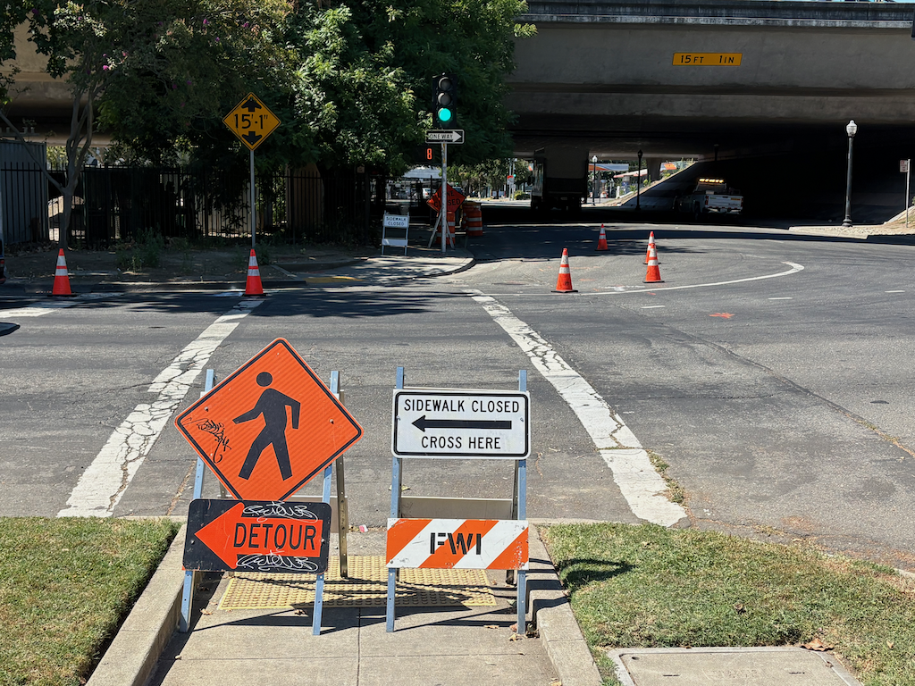
As part of the Fix 50 project, which has been going on for an indeterminate period of time, and may be complete sometime in this century, Caltrans tore up sidewalks and curbs under the freeway overpasses so that they could use the area under the freeways to store construction material and equipment. One locations was 15th Street under Highway 50. The sidewalk was replaced by uneven asphalt pavement, accessible for some people walking, but certainly not people with mobility devices.

15th Street under the freeway has never had sidewalks on the west side. As with almost all Hwy 50 underpasses, the design was for high-speed on-ramps and off-ramps which would have made walking there suicide. And bicycling as well. Cars first, cars only, the Caltrans motto.

Caltrans started to repair the damage to sidewalk and curb on the east side of 15th. Sometime before June 3, a fence was put up blocking the sidewalk. The result is that there is no path for people walking to follow 15th Street under the freeway. This is a violation of PROWAG, which Caltrans, along with every transportation agency, is legally mandated to follow. Though the regulations provide more detail, the summary says it well: “When an entity closes a pedestrian access route for construction, it must provide a temporary alternate pedestrian access route with basic accessible features. Alternate pedestrian access routes ensure that construction in the public right-of-way does not prevent pedestrians with disabilities from reaching their destinations.” Caltrans did not do so. It could have done so by closing one of the motor vehicle lanes and providing a protected pedestrian access route (and a bicyclist route as well, which is not required by PROWAG but is required by the California MUTCD).

So far as I can determine (remember, Caltrans has fenced off this area), the work remaining to be done is to patch the pavement between the curb and the existing roadway. This is something that would take one day, at most. But as of today, June 16, nothing had changed, nothing had been done. Two weeks. This is the middle finger that Caltrans is giving to people walking. Thirteen days, or more, of no access for people walking, for no good reason, just because Caltrans can’t get its act together to fix something it broke.

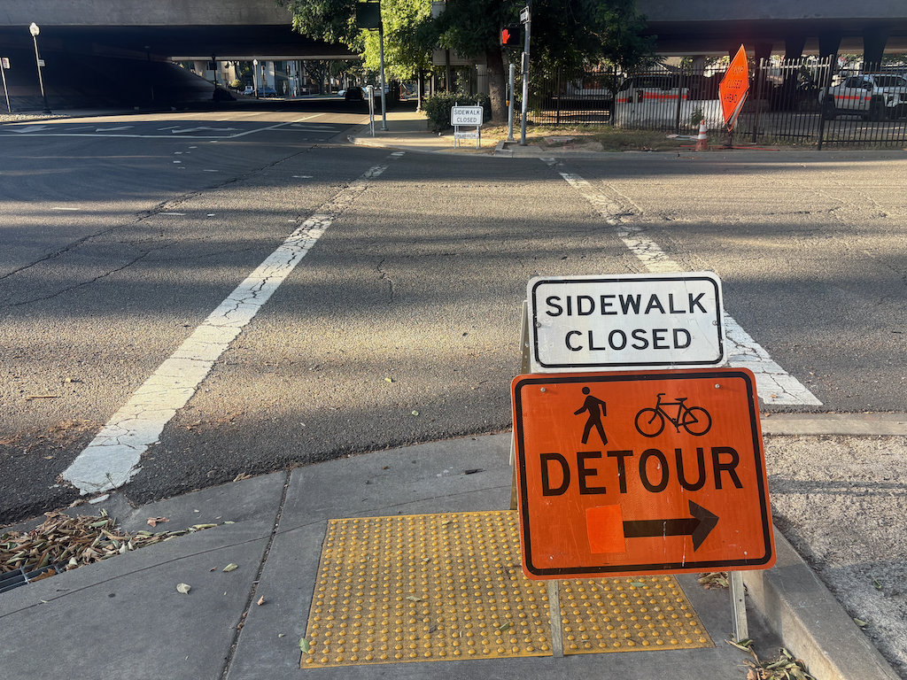
First, what it looks like going south to north on 15th Street. The detour is to… 16th Street, a full block away. That intersection is even more hazardous than this one, with two lanes with high volumes of high speed drivers turning left from 16th Street northbound to W Street westbound. You take your life in your hands there. Actually, you take your life in your hands whenever and wherever you use a facility designed by Caltrans, but 16th Street is one of the worst.

photo of 15th St at X St, pedestrian detour sign
15th St at X St, pedestrian detour sign

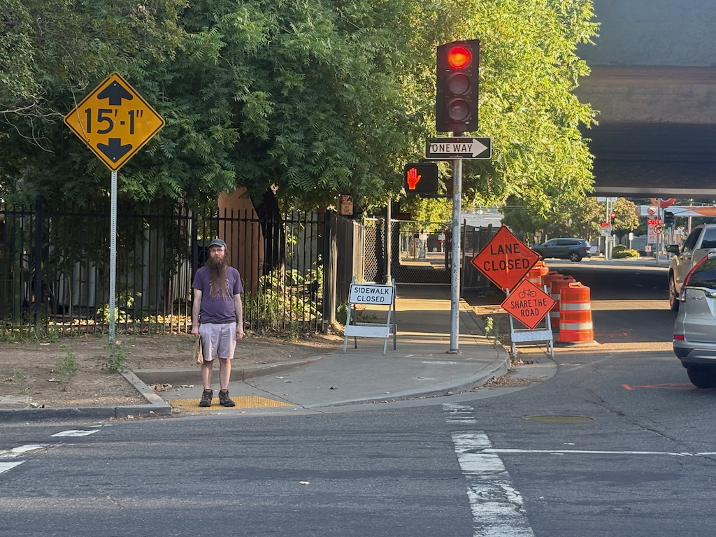
Second, what it looks like going south on 15th Street. You can see the fence that blocks access, but you can’t see, from here, the minor fix that would remove this problem. Apparently the person walking had gone around the fence, unwilling to go two blocks out of their way, to and from 16th Street. This is the target audience for Caltrans, and by ‘target’, I mean a person at risk of bodily injury or death at the hands of Caltrans. At least Caltrans put up a small ‘bicycles share the road’ at a locations where drivers are sure not to see it. This should be an illegal sign in any case, as drivers take it to mean, bicyclists should get out of the way and ‘share’ the road with cars. California MUTCD also required bicyclist accommodation in this situation.

photo of 15th St at W St, pedestrian access blocked
15th St at W St, pedestrian access blocked

And this is what it looked like today, June 16. No change, except that the ‘bicyclists share the road’ sign is gone. Again, the suggested detour is to the even more hazardous intersection of 16th Street and the freeway.

photo of 15th St at W St, pedestrian detour, sidewalk blockage
15th St at W St, pedestrian detour, sidewalk blockage

I have said before, but it bears repeating, that Caltrans District 3, which includes Sacramento county, is a rogue agency, funded by taxpayers (your tax money) but accountable to no one. Not Caltrans headquarters, not California Transportation Commission, not the governor, not the federal government. And most particularly, not the citizens of Sacramento. They do what they want, when they want. They want you to just accept that they are killing you, using your own money for the crime.

I sometimes wonder if the felon Trump got his ideas for grift, criminality and incompetence from observing Caltrans District 3.

Am I pissed? You bet.

Yolo causeway bike path to close

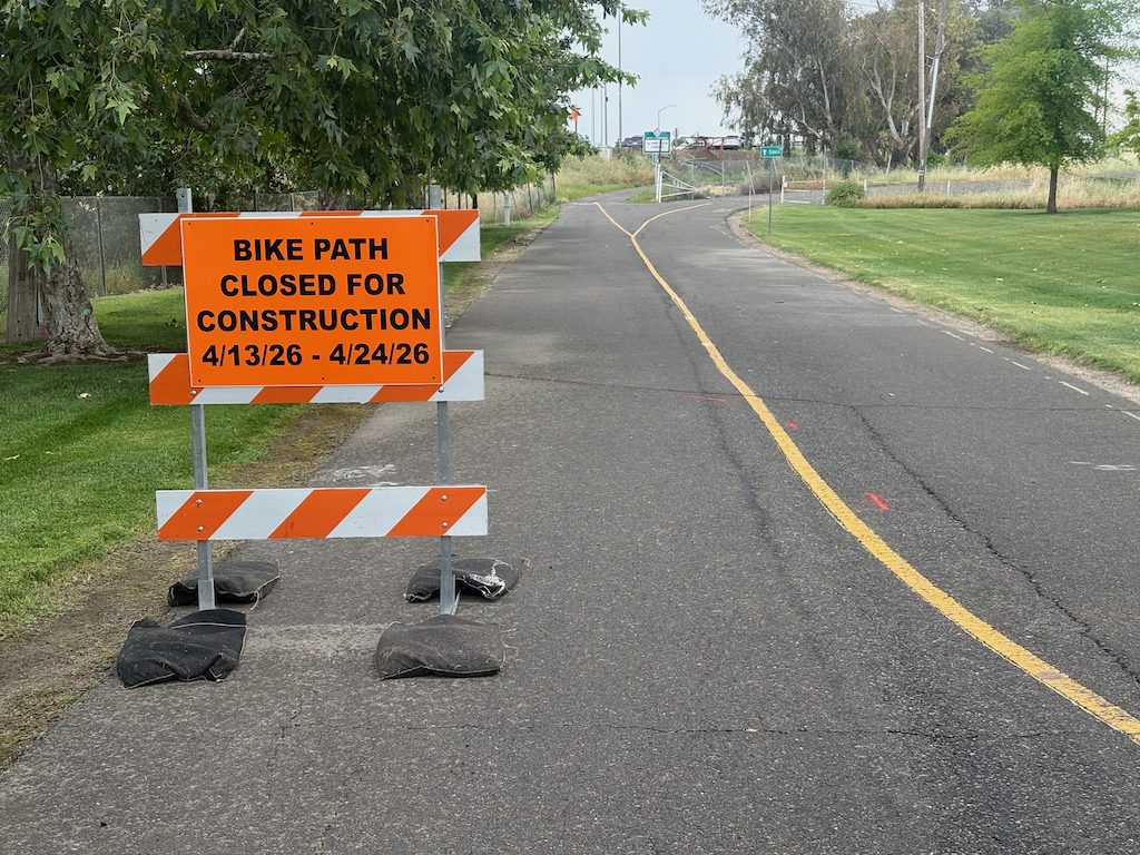
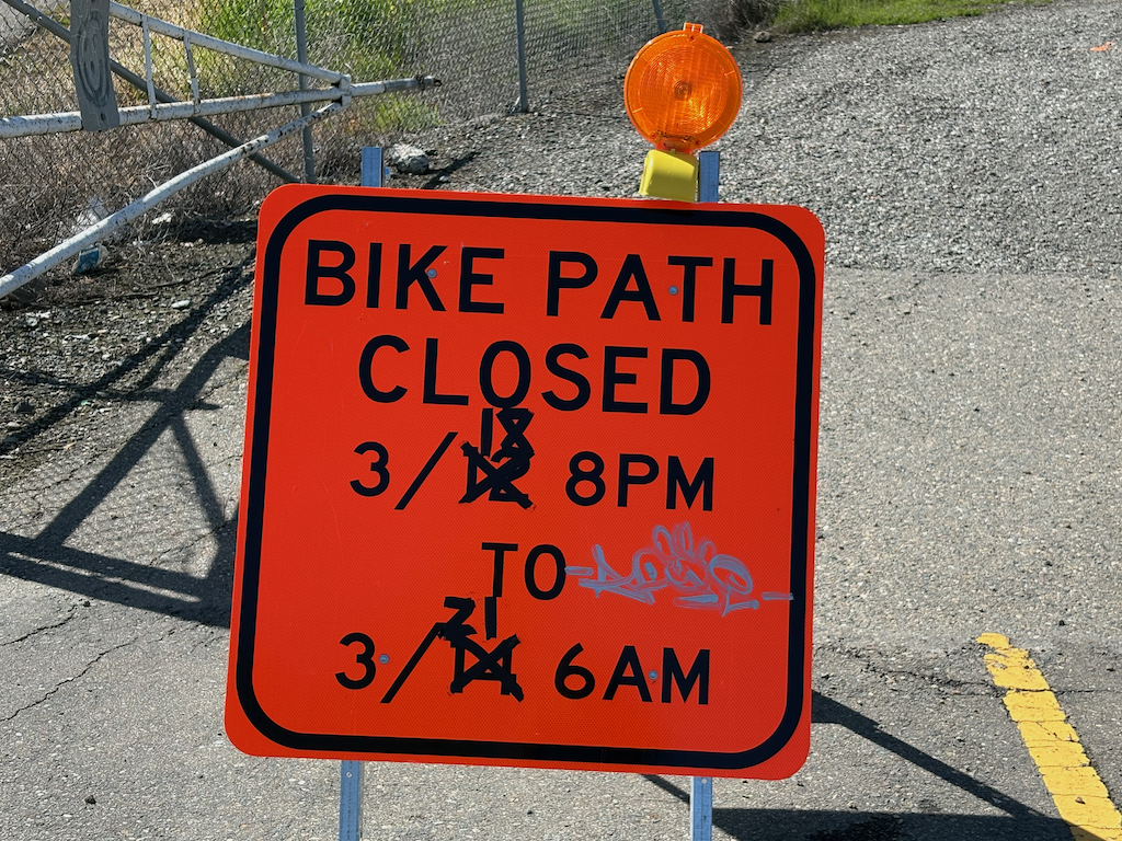
Yolo causeway bike path closed sign

The Yolo causeway bike path will close for a week and a half starting Monday April 13 (tomorrow). The part that will close is actually very short, from the path rest area in West Sacramento to the beginning of the causeway bridge, but since there is no alternative route, the entire distance from West Sac to Davis is closed.

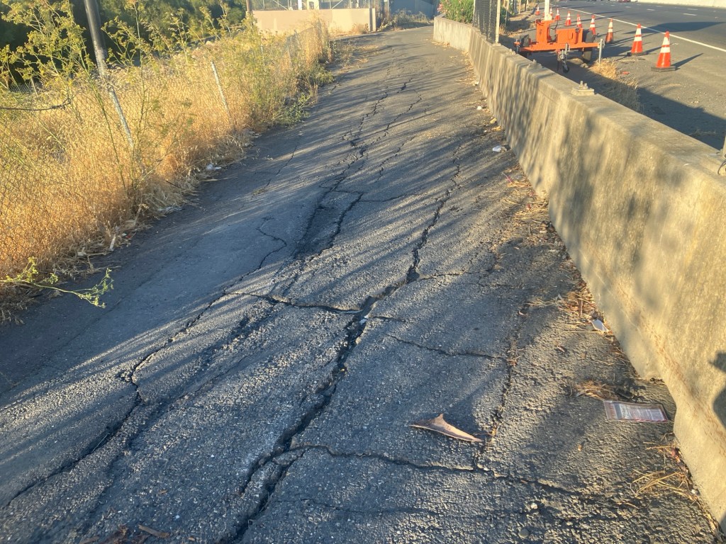
Presumably the closure will be to improve or replace the section of very deteriorated path as it ramps up to bridge level. This is a good thing. The problem is that most users of the path would have no way of knowing beforehand. It is not signed where the path departs West Capitol Avenue westbound, nor is it signed where the path departs County Road 32A eastbound.

Yolo causeway bike path deteriorated pavement

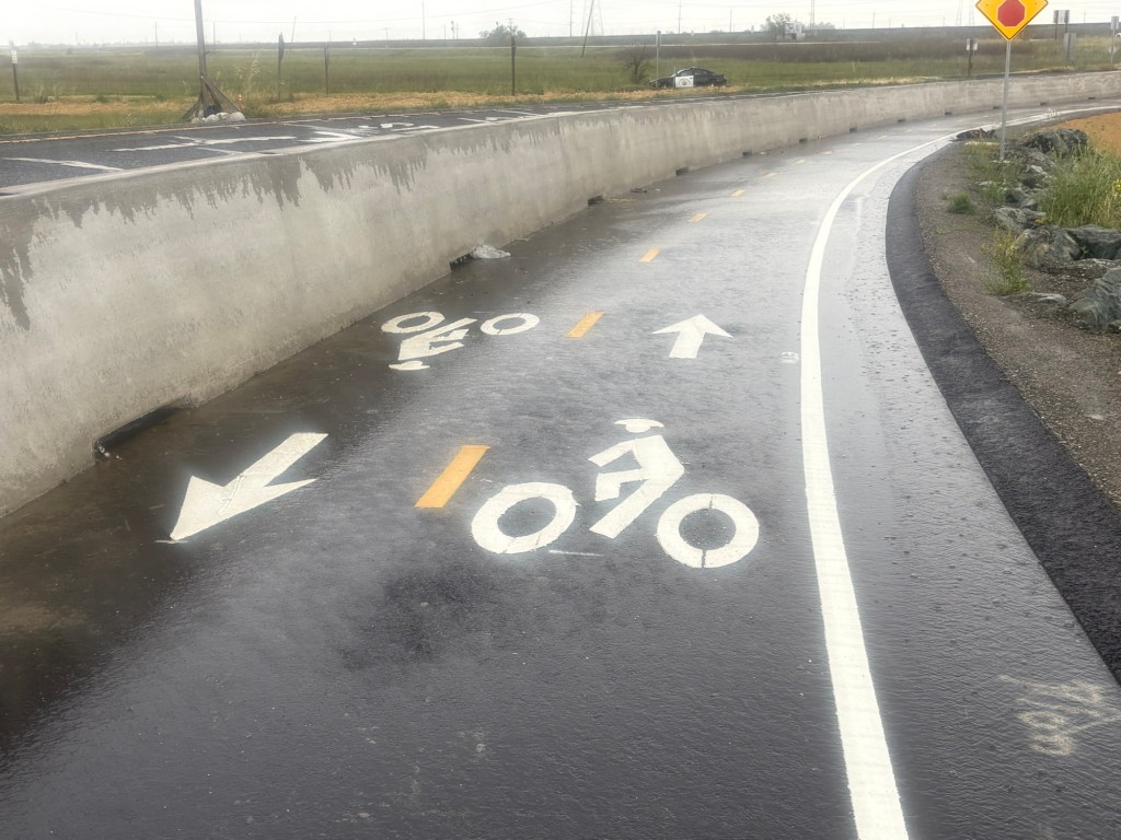
The west end has been improved. Rather than turning on to the levee, it follows the off-ramp from the freeway, protected from motor vehicles by concrete barrier ( sometimes called K-rail or Jersey barrier, but it isn’t clear if this is the term for permanent barriers). However, the junction with County Road 32A is not complete, and may have safety issues.

Yolo causeway bike path approaching County Road 32A

The drainage problems on the causeway portion of the path have not been solved, so there will be extensive puddles after rain, as yesterday. The path continues to collect debris from the highway, car and truck parts and trash. Caltrans passed on the opportunity to provide path lighting, even though electric was embedded in the new barrier. And of course noise from the highway is oppressive. As with all Caltrans projects, two steps forward and one step back.

Caltrans D3 says ‘fuck you’ to Yolo bicyclists

The bike path along I-80 along the Yolo causeway is closed this afternoon (Tuesday, 2:00 PM). The sign at the east entry to the bike paths says:

Bike Path Closed sign on east entry to Yolo causeway bike path

Note that this sign indicates that the path will not be closed until 8 PM on Tuesday, March 18.

This is what the Caltrans website says (UPDATE: Extended 79-hour Closure for Eastbound U.S. Highway 50 in Yolo County Postponed due to Weather Forecast, 2025-03-13, retrieved 2025-03-18 3:00 PM):

screen capture from Caltrans D3 website

Note that this press release says that the path will be open again by 6:00 AM on Tuesday, March 18.

And this is the reality is:

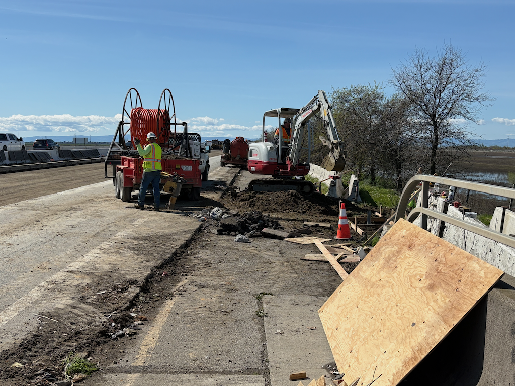
construction on Yolo causeway bike path

Construction is completely blocking the path, at this location and several others. The work to remove the concrete barrier from the freeway is ongoing along the western section of the causeway. Some parts of the freeway are also torn up, awaiting reconstruction.

I talked to the supervisor at this construction location, and he said they are just a subcontractor, not responsible for Caltrans signing, or lack thereof. He called the general contractor, who apparently said it is my problem, not theirs. After exiting at the I-80 off-ramp (the normal entry to the path north to Yolo County 32A is not accessible), I saw a CHP officer, and reported the issue to him. He said he would pass it along. He probably will, but I doubt that either CHP nor Caltrans will do anything about it.

This is an active construction project which was not properly signed for construction. This is a violation of Caltrans procedure, and state law, and federal law.

It is absolutely typical of Caltrans District 3 (which includes Yolo and Sacramento counties) to not care about the travel or safety of bicyclists. What would it take to correct the signing, and to correct the website? Not much, but it is beyond the care and interest of Caltrans D3.

Caltrans has said that as a result of the Yolo 80 project, there would be an improved bike path. I’ve previously written about why that is very likely to be a lie: Yolo causeway bike path. Note that though Caltrans claims the current construction is just bridge rehabilitation and has nothing to do with the Yolo 80 project, that is a lie. It is safe to assume that everything Caltrans D3 says is a lie. Caltrans is a highway department, not a transportation department. They care about motor vehicles. They do not care about walkers or bicyclists or air quality or the state budget. In fact, given the high fatality rate on both under-construction and completed highway projects, they don’t really care about motor vehicle drivers either.

I will also note that the California Transportation Commission (CTC) is complicit in Caltrans D3 malfeasance, as they continue to fund projects no matter what the behavior or violation of the law. And above CTC, California State Transportation Agency, which is intended to oversee both CTC and Caltrans, but does not.

HSIP grants for SACOG region

Caltrans has released a list of $300M in projects under the HSIP (Highway Safety Improvement Program) program of federal funds. See Streetsblog: State Announces Nearly $300 Million in Grants for Safe Streets for more information. The funds are a mix of federal and state, but the awards are selected by the state. Unlike most projects funded by the federal and state, these projects really do have a focus on safety, though the various signals in these grants may be as much motor vehicle focused as walker and bicyclist focused. The City of Sacramento has installed beg buttons, replacing auto-recall pedestrian signals, in an effort to ease traffic flow and only secondarily make it safer for people walking, so there is a concern about how signals will be implemented.

Twenty-three of the projects are in the SACOG region. A pdf of those is available. Presumably descriptions of each project are available somewhere, but I’ve been unable to locate them. If I do find them, I’ll highlight a few of particular interest.

State Rail Plan webinar March 4

Seamless Bay Area and Californians for Electric Rail are hosting a webinar, New State Rail Plan Explained: A vision for an integrated, cohesive California rail network on March 4, 2025, at 12:00 PM. Registration is required, but free.

The Caltrans/California State Transportation Agency 2024 California State Rail Plan (2024-12) is available for review. An earlier draft emphasized hydrogen trains to the exclusion of overhead catenary wire electric trains, but the current version includes catenary, battery electric and hydrogen fuel cell electric.

From the registration page: “The newly released State Rail Plan lays out strategies that can significantly impact how Californians and visitors get around the state – and can make California a place that’s easier for everyone to get around in an affordable, low-carbon, safe, and accessible way. The plan establishes a long-term vision for an integrated, cohesive statewide rail system that offers passenger and freight service and helps achieve California’s mobility, economic, and climate goals. Tune into this webinar to learn about the plan from California State Transportation Agency staff. Researchers and advocates will give their reaction to the updated plan including cost analysis, the political changes needed to implement reforms, and upcoming funding and reform opportunities.”

Whether or not you can attend this webinar, I encourage you to read the 2024 California State Rail Plan, focusing on the routes or concepts that are most important to you.

The Capitol Corridor, Sacramento/Roseville to San Jose, is called out for electrification, but the source power is not defined. Capitol Corridor is not specifically a single project, but part of several projects including Transbay Crossing, Leveraging Mega-Investments, Sea Level Rise, and Sacramento and San Joaquin Valleys. In stages, Capitol Corridor service is planned to reach once per hour in the mid-term, and once per 30 minutes in the long term. Current service is one hour at peak times of day, but two to three hours at other times.

Many transportation advocates strongly support catenary electrification of the Capitol Corridor route between Sacramento and San Jose. I have also advanced the idea of state purchase of the rails in heavy passenger rail corridors, which would include Capitol Corridor, either through willing seller or condemnation if necessary. Freight rolling stock would still be owned and operated by the railroads, but passenger trains would now have priority over freight trains, and the freight railroads could not resist catenary electrification.

I hope to provide more detailed analysis of the state plan in the near future.

timeline for Tier 4 diesel and zero emissions
2050 electrified corridors
long-term service plan

Yolo causeway bike path

Caltrans and Yolo County Transportation District are proposing to widen a section of Interstate 80 from Sacramento to the Yolo/Solano county line, a project called Yolo 80. This is not just a future project, subject to funding shortfalls and lawsuits, but is actually underway, as Caltrans illegally spends funds for highway maintenance on highway widening. I have written a number of posts on Yolo 80 and managed lanes, but today is just about the bike path that parallels Interstate 80 from the west edge of West Sacramento to Davis.

I am not a commuter or regular rider on the causeway path, but I do average riding it about once a week (I like concerts and beer and Mishka’s tea), and have been doing so for about 13 years.

Read More »

SB 960 complete streets signed

Governor Newsom has signed SB 960, the complete streets bill (SB-960 Transportation: planning: complete streets facilities: transit priority facilities.), authored by Scott Wiener. That’s the good news. It is certain that the Caltrans districts will resist this law, but with oversight by CalBike and the public, things will gradually shift.

CalBike series on Caltrans complete streets failure

CalBike has published the first two of a series of reports on the failure of Caltrans to follow their own complete streets policy when designing and building streets which are also state highways. It is telling that the first of the series is on the failure of Caltrans District 3, which includes Sacramento county, to actually provide complete streets – Incomplete Streets Part 1: How Caltrans Shortchanges Pedestrians. District 3 is perhaps the worst of the Caltrans districts, which operate as independent (or rogue) agencies and regularly subvert Caltrans policy and direction from headquarters. Though they have a lot of competition for the title of worst.

“District 3 is perhaps best known as the district pushing through the Yolo Causeway highway expansion project. The project, which has been approved despite internal and external opposition, led to the firing of Caltrans Deputy Director Jeanie Ward-Waller after she blew the whistle on improper use of funds for freeway widening and insufficient environmental review.”

I encourage you to read these first two, and to follow CalBike investigative reporting. Caltrans must be held to account, as otherwise they will continue to design projects that kill and injure walkers and bicyclists, will continue to resist fixing the design mistakes they have made in the past, and will continue to commit fraud on the people of California by lying about what they are doing with your tax money.

complete streets and intelligent speed assist

This week at the legislature, the Assembly Transportation Committee is hearing SB 960 (Wiener) Transportation: planning: complete streets facilities: transit priority projects, Monday, July 1, 2:00 PM in Room 1100 at 1021 O Street in Sacramento (StreetsblogCA: Complete Streets Bill Hearing Next Week). This bill would force Caltrans to follow its own policy on Complete Streets, which is seldom does, and could have a beneficial impact on all street redesign in California as many transportation agencies look to Caltran for guideance.

The Assembly Privacy and Consumer Protection Committee is hearing SB 961 Vehicles: safety equipment (Wiener), Tuesday, July 2, 1:30 PM, in Room 126, State Capitol. The bill would implement Intelligent Speed Assistance for all vehicles except emergency vehicles. Though considerably weakened from the original version, with passive rather than active control, it is still a valuable step forward, and would encourage NHTSA to speed up their policy process, which they have been slow walking (to preserve fast driving).

If you live in Sacramento and can attend, please do. All you can do at legislative hearings is ‘support’ or ‘oppose’, but since most speakers are paid lobbyists, hearing from actual citizens can be powerful.

CalBike What are complete streets? graphic