N Street & 14th Street construction

At a recent meeting, people asked me about the crossing of N Street at 14th Street, what I thought of the pedestrian prohibition, and why I hadn’t reported it as I do most other construction related issues.

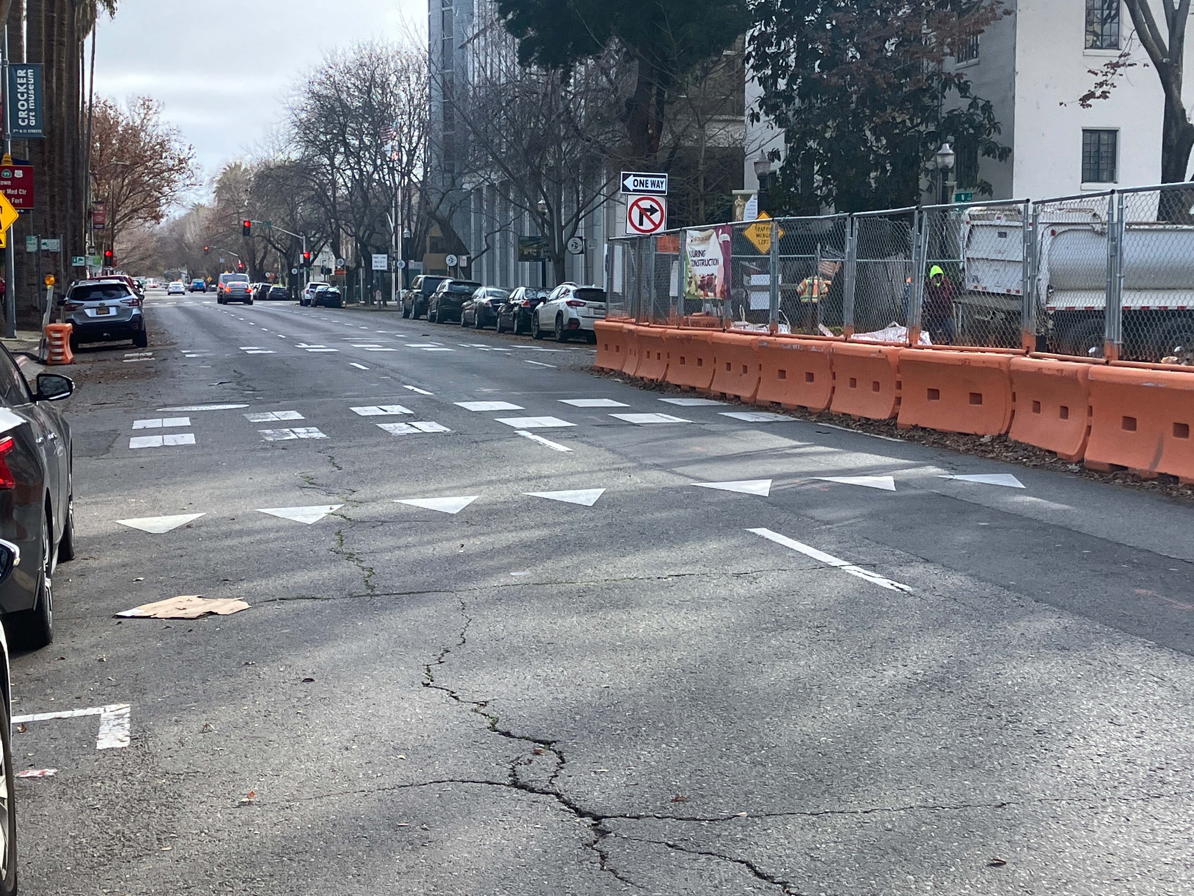
N Street is a three lane one-way street, reduced to two lanes by construction at the state capitol, and the CADA construction project on the southwest corner of N Street and 14th Street. At this construction project, the parking lane and rightmost lane are closed, with a barrier and fence along N Street. The barrier and fence block driver view of the crosswalk on the east side of the N Street/14th Street crosswalk, until just before the crosswalk. This is a situation not addressed by CA-MUTCD, nor the proposed city Draft Criteria and Guidance to Accommodate Active Transportation in Work Zones and at Events, or work zone guide for short.

There are probably ways of safely handling this limited visibility situation, but it is not immediately obvious to me how. So I have not reported the closure of this crosswalk. It is a low volume crosswalk, I believe. Any detour for walkers is an issue, and this one requires a detour of a block to the east or west, because both the east crosswalk and the west crosswalk are closed.

While it is true that this crosswalk closure is no absolutely necessary, it is also true that it would take some sort of traffic control at this location to make it safe for walkers.

photo of N St approaching 14th St, poor visibility
N St approaching 14th St, poor visibility
photo of closed crosswalk over N St at 14th St, east
closed crosswalk over N St at 14th St, east leg, northeast corner
photo of crosswalk closed over N St at 14th St, east, southeast corner
crosswalk closed over N St at 14th St, east leg, southeast corner

update on SacCity new beg buttons on Alhambra

A previous post about new beg buttons on Alhambra Blvd noted that there are now beg buttons where there used to be auto-recall pedestrian crossings. I walked Alhambra this week, and noted that there are eight intersections with these new beg buttons (technically called pedestrian actuators or Accessible Pedestrian Signals APS). At auto-recall crosswalks, the pedestrian signal comes on at every signal cycle. At beg button crosswalks, the signal comes on only if requested by the pedestrian. The city has many of both types of crosswalks, but these particular locations are new. The intersections are Alhambra and: J Street, K Street, L Street, Capitol Avenue/Folsom Blvd, N Street, P Street/Stockton Blvd, Q Street, S Street. At each intersection there are eight of these new beg buttons on new posts, for a total of 64 new beg buttons.

No one seems to know who authorized this project, nor what funds were used to pay for it. I have confirmed that the project never came before the Active Transportation Commission (SacATC). All significant pedestrian projects are supposed to come before SacATC, and the fact that this one did not probably indicates that the staff in Public Works knows that this is a motor vehicle project, and not a pedestrian project. Though it is a good bet that pedestrian safety funds were used to pay for it.

Though these beg buttons are not signed with the ‘wave at’ sign R10-3j(CA) that the new ones at 21st Street and I Street, they do seem to have the same function, that they detect people, waving or not, up to about 18 inches. It seems odd that the city would have purchased these infrared detector actuators, which must be more expensive than plain touch buttons, but then did not indicate them as such. Installation of new accessible pedestrian signals is about $70K per intersection, though replacement of buttons at existing locations is only about $14K per intersection. I have been unable to find costs for passive detection systems (they all seem to require a quote process).

A reminder, if one is needed, that beg buttons have no safety benefit for people walking. They are a motor vehicle device, meant to reduce the length of signal cycles so that more cars can go faster.

The solution to this is to prohibit the use of pedestrian beg buttons throughout the city. Existing locations can be converted to the audible crossing signals that are now required by PROWAG. The relevant sections of PROWAG are R307 Pedestrian Push Buttons and Passive Pedestrian Detection and R308 Accessible Pedestrian Signal Walk Indications. Unfortunately PROWAG does not have a definition for ‘passive detection’ to specify what the detection radius or functionality is. It might be presumed this is the same at automated pedestrian detection, but not certain. Under PROWAG, new or changed locations require audible signals, but this can be met by audible/tactile push buttons or passive detection.

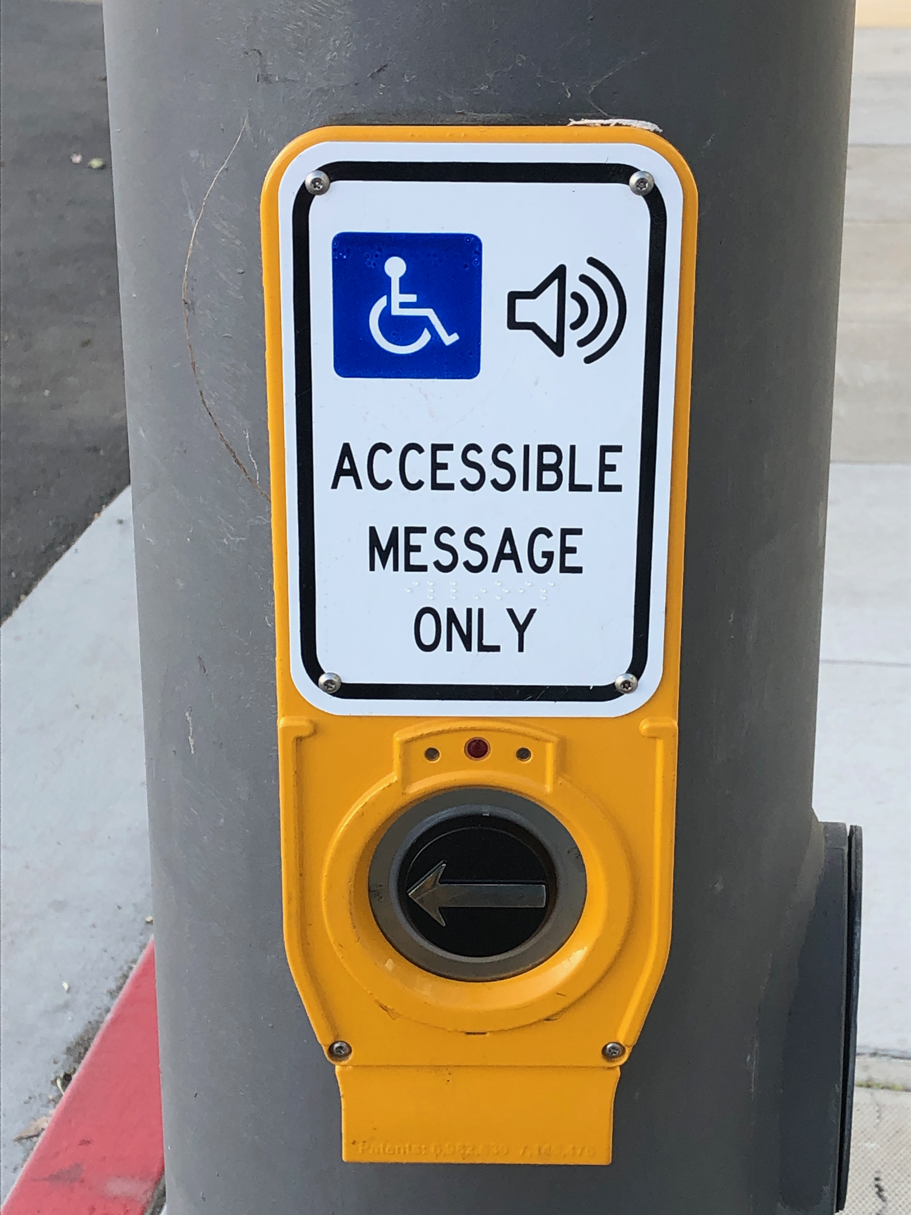
San Francisco is replacing the signing on their pedestrian actuator locations with the signing below.

photo of Accessible Message Only pedestrian button
Accessible Message Only pedestrian button

diagonal ramp corners are now illegal

PROWAG (Public Right-of-Way Accessibility Guidelines) from the US Access Board have now been officially adopted. I’ve only begun to review them, but a few things grabbed my attention right off the bat. From PROWAG:

“At an intersection corner, one curb ramp or blended transition shall be provided for each crosswalk, or a single blended transition that spans all crosswalks at the intersection corner may be provided. Where pedestrian crossing is prohibited, curb ramps or blended transitions shall not be provided, and the pedestrian circulation path shall be either (a) separated from the roadway with landscaping or other non-prepared surface or (b) separated from the roadway by a detectable vertical edge treatment with a bottom edge 15 inches maximum above the pedestrian circulation path.”

This means that the diagonal access ramps at corners, which are common in suburban areas and even a few urban areas, are no longer legal for installation. For any alterations of curbs, sidewalk, or corner, new ramps must be two to a corner, perpendicular, or the ramp must cover the area of both sidewalks. See photo below.

photo of diagonal curb ramp, now illegal under PROWAG, installed May 2023
diagonal curb ramp, now illegal under PROWAG, installed May 2023 by Sac City

Secondly, the pedestrian prohibition signing in common use in the City of Sacramento and many other places is now illegal, because it does not meet the criteria of the bottom edge no more than 15 inches above the sidewalk. See photo below, showing a newly installed curb ramp where the ramp does not extend the full width of both crosswalks. Again, any alteration of the curb, sidewalk, or corner requires compliant design. Of course the majority of these pedestrian crossing prohibitions are unnecessary, and were installed to ease motor vehicle traffic and not to protect walkers, so most should simply be removed, and legal curb ramps installed. The one exception would be freeway on and off ramps that have not been modified to be safe under any conditions.

photo of pedestrian crossing prohibition, now illegal under PROWAG
pedestrian crossing prohibition, now illegal under PROWAG

pedestrian safety countermeasures

As a follow-on to Sac City NEW beg buttons, some background information on pedestrian pushbuttons (beg buttons). The federal government, under the Federal Highway Administration (FHWA) makes available the PEDSAFE: Pedestrian Safety Guide and Countermeasure Selection System. Eleven countermeasures are offered for pedestrian crossing locations:

Note that automated pedestrian detection is among the eleven. Pedestrian pushbuttons are not listed because they are not a pedestrian safety countermeasure.

Now knowing about the Vision Zero update (thanks, Matt), I will see how the city’s list of actions compares to this list of countermeasures.

Sac City NEW beg buttons

I was out walking last evening, and was horrified to discover this:

photo of new beg button at Alhambra Blvd and L Street
new beg button at Alhambra Blvd & L St

This is a brand new beg button (technically called pedestrian pushbutton) on Alhambra Blvd in Sacramento. These have not been turned on yet, hence the cardboard over the button itself, but they are newly installed. There are a number of these along Alhambra Blvd, though I don’t yet know how many. For at least the ones I observed, these are all at locations where the pedestrian signal was previously on auto-recall, meaning the pedestrian signal changes as part of the regular signal cycle, not requiring any action on the part of the walker. Now, with these beg buttons, a person walking must ‘beg’ to cross the street by pressing the button. These buttons do not, at least in Sacramento, speed up the signal cycle. The person waiting must wait the same amount of time before a walk indicator comes on.

This is an affront to myself and anyone who walks. I’m sure the city considers this a pedestrian safety improvement, and I’d not be surprised if the city used pedestrian safety funds to install it. But it is a motor vehicle facility and improvement, it does absolutely nothing for someone walking. What is does do is allow the traffic engineer to favor motor vehicle traffic in signal timing.

The trend all over the US is to either remove such beg buttons completely, or to change them to accessible audible buttons. In a few places, they are being replaced by automated pedestrian detection, so that no action is required on the part of any walker. San Francisco has converted all of its beg buttons to accessible buttons. Other bay area cities have started to do so. I know of no place in the US where new beg buttons are being installed.

City of Sacramento Public Works is populated by fossil engineers and fossilized thinking. It has a cars-first attitude, and will continue to have that attitude until the fossils are cleared out. Put them in a museum of the 1970s, and get them out of our transportation system.

Caltrans likes killer interchanges

See Caltrans Readies Guidance for Complete Streets, with a Giant Exemption (StreetsblogCal, 2023-09-29) and Caltrans: We Need Complete Streets at Freeway Interchanges (CalBike, 2023-09-28).

I worked for 10 years as the Safe Routes to School Coordinator for San Juan Unified School District. Three of those years were focused on Citrus Heights schools, and the rest on schools in unincorporated Sacramento County (Orangevale, Fair Oaks, Carmichael, Arden-Arcade, and Gold River). The interchanges with Interstate 80 presented barriers for students who lived on one side and went to school on the other. They could not walk or bike across the freeway, because the interchanges were designed to be safe only for motor vehicle drivers (and not really even those), not to be safe for walkers and bicyclists. Crosswalks over on-ramps and off-ramps were placed where drivers would cross them at freeway speeds, with poor visibility due to the curves. Bike lanes were usually non-existent, and when they were there, exposed bicyclists to high speed merges at on-ramps and off-ramps. If you have ever had the ‘pleasure’ of walking or riding across one of these interchanges, you will know how scary and unpleasant they are. Generally only ‘fearless’ bicyclists and people who have no other choices will walk or bicycle here.

Since these horrible interchanges were designed and constructed by Caltrans, you might think that they are responsible for fixing them. They deny responsibility. They say to cities and counties, if you want a better interchange, you build it on your own money, or with grants. One of the interchanges in Citrus Heights, Antelope Road, was repaved by Caltrans, and they removed the bike lane from the westbound direction. Of course that bike lane was not safe to begin with, but removing it was criminal.

Same Caltrans denial of responsibility for ped/bike bridges over the freeway. There is one ped/bike bridge over I-80 in the entire stretch between Sunrise Blvd and Watt Ave, a distance of about eight miles. One. And it is no a pleasant crossing to use, often full of trash and graffiti. Again, to the cities and counties, Caltrans says, if you want it, you pay for it, don’t expect it to come out of our budget.

Given this, Caltrans will not even allow the application of complete streets designs to these interchanges. They want them to remain as they are, barriers to travel, and killers of the few walkers and bicyclists who use them.

All of this after spending four years developing a new complete streets policy, which could have been done in a year if Caltrans were not dragging its feet. Caltrans says that it has changed its ways, and is now concerned with people who walk and bicycle. Their actions say otherwise.

$5 billion, or reduce cars

The number of $5 billion (or more) has been bandied about recently as the amount of money we need to fix all the poorly designed and dangerous roads in the City of Sacramento. The number seems reasonable, and I myself have estimated that sidewalk repair alone is $1.5 billion. This is just the city, let alone the county or region. The county and region are in most cases much worse off than the city. I support more funding for this work, some via sales taxes, but more via property taxes. After all, it is property that requires our transportation infrastructure and benefits from a good system.

But what if there is a better way? A less expensive way?

I encourage you to watch the latest (August 24) episode of Not Just Bikes (by Jason Slaughter), titled ‘Even Small Towns are Great Here (5 Years in the Netherlands)‘. He has collected video clips from visits to small towns across the Netherlands. He has two main points about small towns: almost all of them are served by good rail service, and many of the small towns and suburbs don’t need extensive bike structure because there are so few motor vehicles that it is safe and comfortable to ride on any street. My favorite quote from the video is:

“To make a place friendly for cycling, it was more important to restrict cars than it was to build a bunch of expensive bicycle infrastructure. After all, protected bike lanes are just an extension of car infrastructure, right. You don’t need bike paths if you don’t have a lot of cars.”

Not Just Bikes (Jason Slaughter)

A related quote, that I will have to paraphrase, since I can’t find the original source is: We have plenty of space for bikes on our streets, its just that it is currently occupied by cars.

The point, for me, is that we could make much more effective investments if we greatly reduced the number of cars on the road rather than trying to make all our roads safe for bicycling and walking. We need to make car drivers pay the true cost of their transportation choice: fossil fuel extraction, climate change, air pollution, expensive highways, foreign wars and fossil fuel subsidies, and a long list of others. Yes, and making it necessary to build protective infrastructure for walkers and bicyclist to protect them from those drivers. We need to make is more expensive and less convenient to drive, so that people will make other choices.

If we actively and directly reduce car dominance, we might only need $1 billion to fix everything. Still a lot of money, but not out of reach.

Jason moved to the Netherlands from Canada, but the car dominated ‘no places’ that he left are the same car dominated ‘no places’ of the United States, and of Sacramento. In fact, Canada tried to imitate the US, and left themselves impoverished, both economically and mobility wise.

Imagine for a moment, someone saying “Carmichel, where there are so few cars that it is safe to bicycle and walk on any street, and the are great transit connections to all the regional destinations.” They would be laughed out of the room. Yet Carmichael, and unincorporated town in Sacramento County, is about the same size as many of the small cities called out in the Not Just Bikes video. We have designed a horrible world in service of the idea that we can and should drive everywhere. We if we flip that and make it hard and expensive to drive everywhere, places will begin to heal. Even Carmichael.

how do we get more red light cameras?

I live close to Fremont Park in Sacramento’s central city. I walk through the park every day I’m in town, often multiple times. That means I’m crossing through the bounding intersections of P Street & 15th Street, Q Street & 15th Street, Q Street & 16th Street, and P Street and 16th Street, multiple times a day. I also spend a lot of time at Naked Lounge on the southeast corner of Q Street and 15th Street, and some time at Karma Brew on the northwest corner of P Street and 16th Street. That gives me a front row seat to watching the behavior of drivers at these intersections. On nearly every signal cycle, I seem a driver running the red light at each of these intersections. This is not a the exception, it is the rule. By running the red light, I don’t mean entering the intersection on yellow and finishing on red, I mean entering the intersection on red. I mean drivers that are intentionally endangering themselves, other drivers, bicyclists, and walkers. Every signal cycle.

Though I’m an able-bodied and aware walker, Fremont Park is also used by a lot of homeless individuals, families using the playground, people sitting on the benches and reading, people lying on the grass and enjoying the sun (finally) and enjoying the shade (now), people participating in a number of organized recreation activities such as yoga, and of course the festivals such as Chalk It Up. This is a place that should be safe to get to for everyone. It is not currently.

I wrote about a crash at P Street and 15th Street. I’ve written multiple times about red light cameras, pandemic of red light running, red-light-running bullies, and SacCity red light cameras and crashes.

Let me state up front that I am NOT in favor of the enforcement of traffic laws by armed police officers. I have seen first-hand the way in which traffic stops are used to harass and oppress people of color and low income. I have read and seen innumerable accounts of officers murdering the people they stop on pretext. Armed law enforcement is the problem, not the solution. On the other hand, I am strongly in favor of automated enforcement. It is my theory that most serious traffic violations are by a small number of egregious drivers. Automated enforcement can ticket these drivers, which will change the behavior of some of them, but not of many of them who are high income drivers of high end vehicles. It does, however, allow law enforcement to identify repeat offenders and hold them accountable with vehicle confiscation and drivers license suspension.

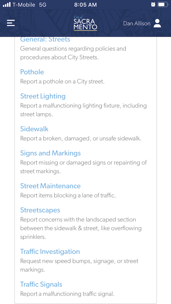
I want there to be red light enforcement cameras installed on at least one of the four intersections at Fremont Park. My observations indicate that the intersection of Q Street and 15th Street is the worst. I looked on the city’s Red Light Running Program page to see if there was a mechanism for submitting requests. No. I looked at the city’s 311 app to see if there was a place to submit a request. Not really. The closest I could find was to select Streets > Traffic Investigation, and then Signals (see screenshots below). I’ll update this when I get a response (though these days most 311 reports get no response at all).

The other way of request that might be effective is to directly contact city council members.

Walkable City Book Club

A local transportation advocate Tom has started a discussion group/book club for the book by Jeff Speck, Walkable City: how downtown can save America, one step at a time. The third meeting of the group will be this Wednesday, May 17, 6:00PM at Lefty’s Taproom, 5610 Elvas Ave, Sacramento, CA 95819. The meetings will likely be on the second Wednesday of the month, same time and location, but his meeting will be the third Wednesday. You may just show up, and you may also send me your email address (to allisondan52@gmail.com) and I will get you added to the announcement list. Lefty’s has beer, wine, and food, but you are not obligated to buy anything. We meet outside.

The group has been going through the book part by part, and this meeting will focus on Part 3: Get the Parking Right. If you can read ahead of time, great, but you can also just show up. The group is a variable number of people and a variety of backgrounds and interests, so you will fit in.

This second edition, ten years after the first, has additional information since that time. Sometimes Jeff amplifies what he said before, or brings things up to date with what has happened in the last ten years. He makes up for his prior lack of emphasis on equity. And if a few cases, he simply say – I was wrong! If you have a choice, get the second edition, which contains all of the first, plus new info. But if you have the old, don’t worry, because we won’t get to the new for a while.

If you don’t have a copy of the book, Sacramento Public Library has three copies. The original edition, 2012, is on the shelf at Central and Carmichael branches. The second edition, 2022, is checked out as of today (probably a book club member!). For the discussion of the parts, which are little changed from the first edition, either will serve you. You can order a copy from your local bookstore ($20). My local bookstore, Capital Books, does not have it in stock but can get it in two days. Amazon has a Kindle edition, if you prefer digital over a physical book ($12.99). But you don’t have to have your own copy, nor even have read the part to be discussed. Your presence is welcome in any case.

Walkable City is a seminal work in transportation urbanism. This book, and his Walkable City Rules, are must-reads for anyone who cares about their city, and livability, safety, and fiscal responsibility. Even if you can’t make the book club meetings, I highly recommend you read it!

SacCity ADA ramps and Central City Mobility

This is Central City Mobility Project update #3.

I now know why all the of initial ADA ramp projects were on 21st Street. That is the first street being repaved as part of the Central City Mobility Project. 21st has been identified in the project for separated bikeways. Since there is a bus route on 21st (SacRT Route 62), I assume that the bus stops will be on the right hand side northbound, and the bikeway on the left hand side. The design shown on the project webpage shows a parking-protected separated bikeway on the left, along with a buffer zone (to protect against car doors opening). This seems to be the standard that the city has adopted, and side so far the city is placing separated bikeways only on roadways that also have bus service, presumably this design will be used in every case.

Another diagram indicates that there will be vertical delineators (K-71) in the buffers, but there are no details about the frequency. There’s are the delineators that are run over and destroyed by vehicle drivers on a regular basis, and these will suffer the same fate. The larger diameter delineators (NOT bollards, the city is incorrect in calling vertical plastic a bollard; bollards are made of metal or concrete, not plastic) that are now installed on part of J Street are not specified here. Though these don’t provide any more actual physical protection, they seem to raise doubts among drivers and get run over less often.

diagram of separated bikeway

There were several curb islands along 21st Street on the left hand side. All but one have been removed. The remaining one at 21st Street and Capitol Ave may just be an oversight, but if not, it is in the middle of what is expected to be the separated bikeway.

21st St at Capitol Ave SW corner curb islands
Sac_21st-St-Capitol-Ave-SW_curb-islands

The fourteen blocks of 21st Street from W Street to H Street has been stripped down about two inches, for repaving. The restriping after paving will include the separated bikeway.

The project webpage has a diagram for the transition of a separated bikeway on the left side of 19th Street southbound to the right side of 19th Street south of W Street, which is a two-way street. However, it does not have a diagram for the transition of this 21st Street separated bikeway at the north end, where 21st Street becomes a two-way street at I Street. This is already a hazardous intersection due to the double left-turn lane from 21st Street to I Street westbound.

Separated bikeways are only as safe as their intersection treatments, and the transition from and to separated bikeways to regular bike lanes are critically important. I hope that the city has a good design for 21St Street and H Street, otherwise bicyclists will be placed in more danger than existing conditions. The solution is of course bicycle signal faces that allow bicyclists to move when other traffic is held, but the city has been reluctant to use these.

Read More »