update on SacCity ADA ramps

Note: I discovered that I have often used ‘detectible’, but should have been using ‘dectectable’ for detectable warning strips.

This is Central City Mobility Project update #2.

This is an update to the update on work being done on corner ADA ramps in the Sacramento central city, apparently as part of the Central City Mobility Project.

So far as I have seen, curb extensions are not part of this project.

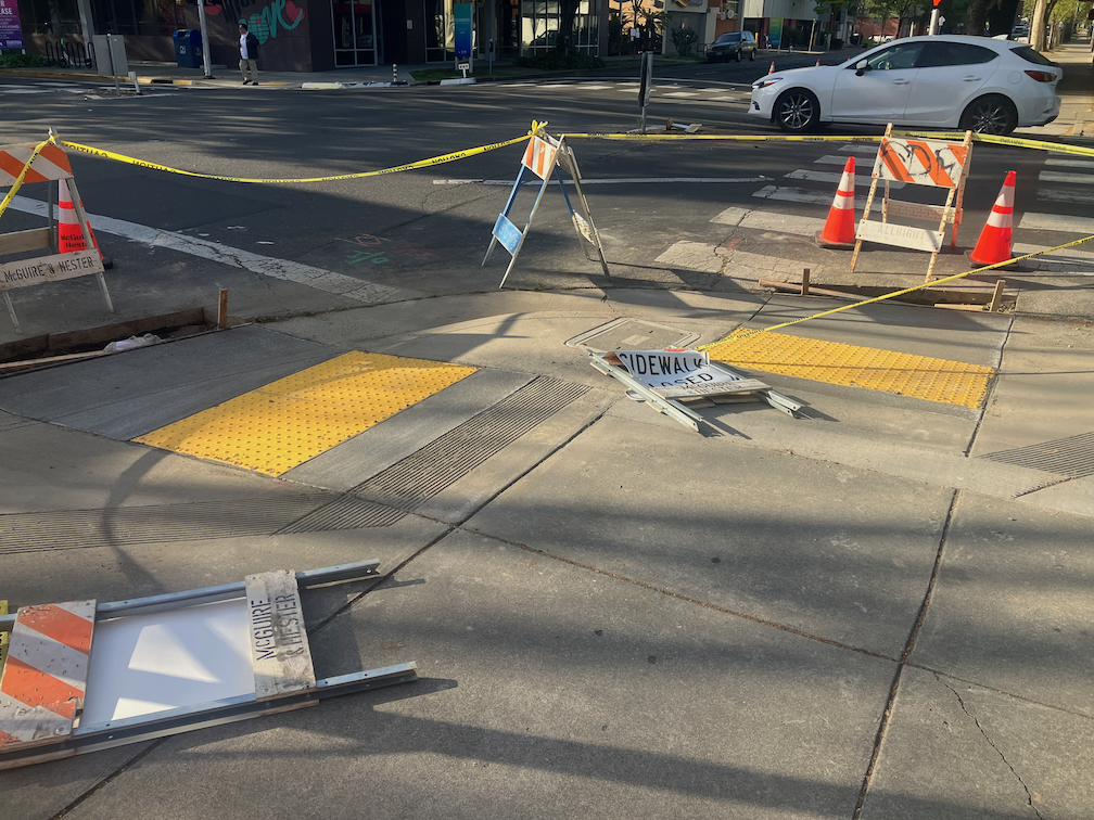
There are now a number of locations where the concrete ramp is being cut so that the detectable warning strip can be installed, but the curbs are not being touched. See below for an example.

Q-St & 16th-St, SW corner, ADA ramp construction

One of the corners I have been monitoring, 21st St and O St northeast corner, is complete, but with temporary patches that make the ramps useable, though ironically still blocked by folding barricades and caution tape, which absolutely does not meet ADA guidelines for contruction signing and safety. This seems to be the pattern with the city, trying to make things better, but not paying attenteion to the details. I don’t know when the asphalt will be restored and the corner opened. Maybe the contractor is waiting until all the corners are ready before patching, though that would be stupid.
21st-St & O-St, NE corner, completed corner with ADA ramps

I am still not able to make sense of the asphalt cuts that are being done on the corners where the curb will be or has been modified. I’m guess that there was a standard cut design, implemented everywhere, no matter what the actual project.

Walking around the central city, it appear that most of the corners which did not have ADA-compliant ramps will have them when the project is done, but some may not. I don’t know what the criteria is for which corners are being done, and which are being done at a higher level of replacing the curbs and widening the ramps. Many of the existing ramps are narrow, with edging curbs, which was apparently the design at the time they were placed, but the new corners are a different design, with a sloping area between the two ramps, similar to the diagram below, from the 2020 Department of Utilities Standard Specifications: Transportation drawings, not from the 2009 Department of Public Works Street Design Standards, which contain no ADA diagrams. I think the detectable warning strip width is at least 60 inches on the new installations, which is an improvement. The 48 inch width does not allow two people to stand on the strip. Corners with new curb extensions seem to have 72 inch strips.

SacCity T-76 Curb Ramp Dual Combination Planter diagram
SacCity_T-76_CurbRampDualCombinationPlanter

update on half-measure corners

This is Central City Mobility Project update #1.

There has been construction on several of the corners I had previously mentioned (half-measure corners?), with 21st Street and O Street being the most advanced. It seems that I was wrong about curb islands being put in – there is no evidence of such construction. I don’t know why the asphalt cutting implied that. When more of these are complete, I’ll post again.

What seems to be going on is simple updates to place ADA-compliant curb ramp with detectable warning strips. Of course any improvement to curb ramps helps everyone, disabled and otherwise, and I’m not criticizing that. Rather, wondering why when the city is changing these corners, they did not take the opportunity to do true curb extensions. The ADA ramp and detectable warning in place for O Street is wider, than previous ramps and strips, looks to be more than four feet rather than the prior narrow ones. If all the ramps end up wider, that will be a plus.

This work is probably part of the city’s Central City Mobility Project. The project detail mentions ‘turn wedges’. Maybe the wedges will be added later, or maybe these will be at different locations than the ones I’ve looked at. The page does not specifically mention ADA ramp improvements.

21st St & O St, northeast corner, ADA ramp construction, partially complete

I had mentioned in the previous post curb extensions being extended to serve as bus boarding areas. I am not aware of any of these in Sacramento, but San Francisco has many. Many earlier posts have mentioned bus boarding islands, but this is for a street without bike lanes (yet), which allows the bus to stop in-lane and people to board directly. Notice that the extension allows for a bus shelter without constraining the sidewalk width for walkers. This should be the standard for Sacramento for all streets with bus routes but not bike lanes.

curb extension and bus boarding extension, San Francisco, Leavenworth & Sutter

complete streets failure

Summary: Complete streets concept is a failure because it doesn’t address frequent safe crossings. It leaves streets dominated by motor vehicle traffic while not necessarily increasing safety or welcoming design for walkers and bicyclists.

A recent post on Strong Towns (Ager Road: Where Complete Streets Fell Short) shows a street that was converted to a ‘complete street’, and won awards, but is actually less safe and less pleasant than what was there before. A fatality occurred shortly after the conversion, perhaps as a result of the conversion increasing vehicle speeds, perhaps not, but the conversion did nothing to reduce the likelihood.

From the post: “This is a stroad in disguise,” remarked Strong Towns Director of Community Action Edward Erfurt when examining Ager Road in Hyattsville, Maryland. And a Twitter post below.

My response:

The complete streets concept is largely a failure, everywhere it is implemented. I’m sure the original intentions were good, but every complete street project I’ve seen affirms the primacy of motor vehicles over other modes. The greatest failure of all is not what happens along the street, but that the concept does not even address the need for frequent safe crossings of the roadway. No wonder traffic engineers have embraced the concept – it allows them to continue motor vehicle dominance and accept traffic violence.

Dan Allison

So you can see the present ‘complete street’ more clearly:

Google Street View of Agar Rd, referenced on Strong Towns

The complete Streets concept is all about travel ALONG streets. Though it recognizes that crossings of streets are important, and encourages designs that make crossing safer and more welcoming, it does NOT address the frequency of safe crossings. The Complete Streets Coalition, part of Smart Growth America, does not require that complete streets policies include anything about the frequency of safe crossings. And so nearly all polices do not address that. The Caltrans policy, which applies only to state highways but is often applied to other streets, does not mention the frequency of safe crossings.

Traffic planners and engineers have embraced the Complete Streets concept, and tout policies and implementation. But what do we really end up with in most cases? Just more motor vehicle dominated streets, which is what most traffic planners and engineers want anyway, and claiming a complete street isolates them from criticism of the roads being designed and built, while making it more likely that they will be a federal, state, or regional grant for their project. Very few projects are awarded grants these days unless they claim to be a complete streets project. That is good, but the bar is set so low for what can be called a complete street, that the result is just more car infrastructure.

The project shown in the Strong Towns post checks off the following elements:

  • sidewalk, check
  • bike lane, check
  • green paint, check
  • general purpose lane(s), check
  • fence to prevent walkers from crossing any place other than the signalized intersection, check (I put this here with tongue in cheek)

What it does not check:

  • narrow the travel lanes to calm traffic
  • reduce the speed limit or actual speed through design
  • remove slip lanes (ask any bicyclist how they feel about bike lanes that cross high speed slip lanes)
  • reduce the corner radius at driveways
  • install or maintain street trees to calm traffic and provide shade for walkers
  • widen sidewalk buffers to ensure healthy trees and vegetation
  • create a pleasant walking environment
  • provide wayfinding to the nearby Metro station

The next time you hear a planner or engineer mention ‘complete streets’, hold on to your wallet (because, after all, it is your tax dollars that fund ineffective projects), and look around you to identify the traffic violence that will remain or even be increased.

The first step in designing a safe and welcoming streets is top ensure that there are safe and welcoming sidewalks and crossings of the street. Everything else comes after that, if at all. Adding bicyclist facilities that are neither safe nor welcoming, and reducing the the environment for walkers in trade, is going the wrong direction, and will lead to less walking and more traffic violence.

half-measure corners?

Summary: The city should not install curb islands at corners, as it is currently doing, but rather install much safer and more effective true curb extensions, even if fewer can be installed now. Temporary installations can be used at other corners.

The City of Sacramento is currently re-doing a number of intersection corners in midtown. Most of these corners are along 21st Street, so far as I’ve noticed, but some are on other streets, and there well may be other locations I’ve not noticed yet. Last week crews were out saw cutting asphalt at corners, in preparation for new concrete work. The existing corner concrete and ramps have been removed from at least two corners, and at the 21St Street and O Street corner there is form work for whatever is going to replace the old corners.

The first photo is of the saw cuts at P Street & 19th Street. The cuts don’t really stand out, but they do indicate the areas that will be changed.

19th St & P St, SW corner, asphalt cuts for corners changes

It appears from the saw cuts that what is going to be constructed is something similar to the existing northwest and northeast corners. Northwest is shown below. I am not sure what to call these. They are not in the city’s street design standards, and almost the only place where I’ve seen them is Sacramento. I looked at several other cities to see if these were in their street designs, and they were not. So, just to call them something, I’m going to call them ‘curb islands’. The City of Los Angeles calls these floating curb extensions, but apparently their intended use is with bike lanes, not with gutters.

19th St & P St, northwest corner, corner islands
Read More »

SacCity sidewalk design standards

I’ve written about existing sidewalk buffers or lack thereof (sidewalk buffer widths), and a solution for areas without sidewalk buffers (street trees in the parking lane), and now on to sidewalk standards. Sidewalk areas are composed of the sidewalk, sidewalk buffer (also called planting strip or furniture zone), and pedestrian scale lighting.

Design criteria:

  • All new or reconstructed streets will have sidewalks, sidewalk buffers, and pedestrian scale lighting
  • Reallocated or mitigated streets will have sidewalk buffers added if right-of-way can be reallocated
  • Sidewalk areas may also include sidewalk-level bicycle facilities
  • Attached sidewalks (sidewalk adjacent to the curb) will not be used for new or reconstructed streets
  • Sidewalk width:
    • Minimum sidewalk width will be six feet in areas of 85% of more residential
    • Minimum sidewalk width will be eight feet in all other areas
    • Sidewalks must be completely free of obstructions, encroachments, or driveway aprons into their minimum width
    • Sidewalks adjacent to and within 1/8 mile of schools will be a minimum of 8 feet; sidewalks used for drop off/pickup will be a minimum of 10 feet
  • Sidewalk buffer width:
    • Minimum sidewalk buffer width will be eight feet in order to accommodate a canopy of mature trees; if a lesser width is available, parking areas will be considered for tree placement
    • Sidewalk buffer may also accommodate street related infrastructure and utilities, street furniture, bike and scooter parking, dining areas, bioswales, and other related uses
  • Sidewalks will receive priority use of right-of-way; travel and parking lanes, and bike facilities, will be placed in remaining right-of-way
  • Bus stop amenities will not be placed within the sidewalk minimum width; the sidewalk buffer may serve as clear sidewalk abutting the curb, with appropriate design and transition; transit amenities may also be placed on transit islands away from the sidewalk and sidewalk buffer
  • Sidewalks will be continuous over driveways and alleys, without interruption of design or materials
  • Pedestrian scale lighting will be provided along the street length; motor vehicle scale lighting will not be considered sufficient; intersections and crosswalks may be lit with motor vehicle scale lighting

Design diagrams:

  • Sidewalks of six or eight feet, with sidewalk buffers of at least eight feet
  • Tree planters or wells in the parking lane or curb extensions
  • Alley entrances and sidewalk crossings of alleys
  • Driveway crossings of sidewalk, with design indicating walking priority
  • Bus stop amenities (benches, shelters, etc.) with a sidewalk area clear of encroachment
  • Transit island diagram here or in the transit section
walkers at Capitol Park sidewalk N St & 15th

AB 825 (Bryan) Safe Passage for People on Bikes

Assembly Bill 825 been introduced to the California legislature by Issac Bryan. The bill would allow bicyclists to use sidewalks where safe street bicyclist facilities have not been provide by the transportation agency. Class 1 separated paths, Class 2 bike lanes and Class 4 separated bikeways are considered safe facilities. Note that Class 3 bike routes, which are only signing and sometimes sharrows, are not considered safe under this bill. It would limit speed on sidewalks to 10 mph and require that bicyclists yield to walkers. The bill passed Assembly Committee on Transportation last week and will go to Assembly Committee on Appropriations.

Take at look at the CalBike Support AB 825 for Safe Passage for People on Bikes page for more information, including a link to email your assembly member.

I posted two day ago about bicycling on sidewalk codes in Sacramento county. The county and all the cities prohibit biking on sidewalks unless they are recognized in the bicycle plan as being bike facilities. There are very, very few such designations. The City of Sacramento takes the reverse approach, that it is legal except where signed against, and there are currently no locations signed against.

Again, I’ll say that I don’t like bicycling on sidewalks, and I don’t do it, but I completely understand why others do. The are making the best decision they can to keep themselves safe from traffic violence. This bill recognizes that reality.

bicycling on sidewalks

The release yesterday of the report Arrested Mobility: Barriers to Walking, Biking, and E-Scooter Use in Black Communities in the United States demonstrating that tickets for riding on the sidewalk are one of the ways in which laws and law enforcement discriminate against black bicyclists, and Latinx bicyclists as well.

Let me say that I am not in favor of bicyclists on sidewalks, but the conflict between bicyclists and walkers is often exaggerated, and bicyclists are making the best decision they perceive to keep themselves safe from traffic violence. I don’t do it, but I understand why other people do.

So what is the situation in the Sacramento region?

City of Sacramento code 10.76.010 Riding bicycles on sidewalks prohibits bicycling on sidewalks only where signed and where in-street facilities are provided. The code says:

  •  A. No person shall ride a bicycle on a sidewalk where a sign is posted indicating that bicycling is prohibited. The city manager shall designate sidewalks where such signs are posted upon a finding that:
    • 1. The sidewalk abuts a road that is designated a “Low Stress Bikeway” using the criteria for the Facility Selection Guidelines in the City of Sacramento Bicycle Master Plan; and
    • 2. There is either a demonstrated or probable conflict between pedestrians and bicycles. This may be shown by information including, but not limited to: 311 reports, incident data, or estimated high pedestrian activity determined by counts or adjacent land uses and densities.
  • B. Subsection A of this section does not apply to the following persons:
    • 1. City employees acting within the course and scope of employment, including but not limited to:
      • a. Peace officers, as defined in California Penal Code section 830.
      • b. Emergency medical personnel as designated by the fire chief of the city.
      • c. Parking enforcement officers.
    • 2. Children under the age of 18 years old and an accompanying adult.
  • C. Where bicycling on a sidewalk is permitted, the following apply:
    • 1. Bicyclists must yield the right-of-way to pedestrians by slowing down, stopping, or dismounting, as needed.
    • 2. Before passing a pedestrian traveling in the same direction, bicyclists must give the pedestrian an audible warning.
  • D. The city manager or designee shall report to the city council annually regarding the impacts of sections 10.76.010 and 10.76.030. (Ord. 2019-007 § 2; Ord. 2017-0033 § 1; Ord. 2016-0024 § 1; prior code § 25.05.070)

There are some designated bike routes on sidewalks in the City of Sacramento, which were designated before this code came into effect and are still valid. N Street between 8th Street and 15th Street, and the area through the convention center/performance center between 13th Street and 14th Street.


SABA has a summary of sidewalk riding rules, on Sharing the Road page, scroll down to ‘Is it legal to ride on the sidewalk? This page may be out of date.

Note that the County of Sacramento, Elk Grove, and Rancho Cordova code sections are identical, and the Folsom and Galt code sections are identical, examples of mindless copying of code from other locales.

I do not have any information on whether these codes are being enforced in a discriminatory way, but given the almost universal pattern of law enforcement oppression of people of color, I’d not be the least surprised.


On the positive side, AB-825 Vehicles: bicycling on sidewalks (Bryan) has been introduced which would prohibit sidewalk prohibitions except where there are high quality bicycle facilities available on the street,  invalidating all of these code sections except, perhaps, the City of Sacramento. The relevant paragraph is: Notwithstanding paragraph (1), a local authority shall not prohibit the operation of a bicycle on a sidewalk adjacent to a highway or corridor that does not include a Class I, Class II, or Class IV bikeway, as defined in Section 890.4 of the Streets and Highway Code.

I hope readers will support this legislation. The bill passed the Assembly Committee on Transportation on March 20, 2023, and was referred to Assembly Committee on Appropriations, but not yet scheduled. See also Streetsblog CA Traffic Safety Bills Pass First Committee.

If passed, the legislation might well cause cities and counties to accelerate projects to add safe bicycling facilities to streets, in order to reduce sidewalk riding. One can hope.

sidewalk buffer widths

One of the elements of street design is the width of sidewalk buffers, and how these are presented in design standards. The sidewalk buffer is the area between the curb and the sidewalk. The city calls sidewalk buffers ‘planting strips’, and this is often how they are used, but it is not the only use, and in more urban areas, there are often multiple uses of the sidewalk buffer.

I did a sampling of sidewalk buffer widths in the central city, and a few other parts of Sacramento. I am not claiming any insight into the overall pattern. The city does not have a publicly available database or GIS layer of sidewalk locations and widths, let alone locations and widths of the buffers. I have heard rumors that they are developing one, but I have been hearing that rumor for the last ten years, so I’ve become doubtful.

Typical buffer widths in the central city range from six feet to nine feet, with seven feet being the most common. With huge mature trees, the narrower buffers are too narrow of the trees, and the sidewalks have had to be modified. The photo below shows an example, and these situations are everywhere.

sidewalk narrowed for tree roots, Q St near 14th St
Read More »

sidewalk-level bikeways

Given the issues raised by the need for wider bikeways to accommodate wider devices and passing, the topic of my bike lane widths post, I am starting to think more and more about sidewalk-level bikeways, where the bikeway is at the same level as the sidewalk, and not at street level. The street-edge curb provides a good separation between motor vehicles and bicyclists and walkers (not perfect, drivers do ‘accidentally’ or intentional cross curbs). I am concerned that as street-level bikeways become wider, there will be more and more motor vehicle intrusions.

Here are are two diagrams from the Portland Bureau of Transportation (PBOT) Pedestrian Design Guide (2022), page 28. The first uses a tactile divider between the sidewalk and bikeway, the second a buffer similar to the regular sidewalk buffer, but with reduced width due to the greater separation from motor vehicle traffic as compared to regular sidewalks. Note that the street classification system that PBOT uses is interesting, but probably more than is needed in Sacramento for the Street Design Standards update.

bike lane widths

Note: NACTO table for two-way bikeways added.

I just came across the NACTO publication Designing for Small Things With Wheels, released February 2023. I’m still digesting the publication, which is available online for download. Already it has been eye-opening for me, a person who used to keep up with bikeway designs, but hasn’t paid much attention recently.

The working paper’s basic premise is that bikeways must be designed for the modern complement of devices, with widely varying widths, and also that bikeways must be designed so that people can safely and easily pass each other. Bike lanes have gradually evolved from 4 feet to 5 feet to 6 feet, but at least in Sacramento and the region, have not gone beyond that. But the working paper indicates that we need to start with 8 feet, to accommodate cargo bikes which are becoming much more common in the region, and go up from there. A chart from the working paper is below (page 11).

chart for bikeway width, NACTO Designing for Small Things with Wheels
chart for two-way bikeway width, NACTO Designing for Small Things with Wheels

Given that I believe that motor vehicle design speeds over 30 mph require separate bikeways to keep riders of all ages and abilities safe, this means future separated bikeways should be a minimum of 8 feet. However, bikeways this wide encourage motor vehicle drivers to use them for travel, and to park in them, ‘for just a moment’ or longer. My take is that this means we must create bikeways that are at the sidewalk level, or if street level, that are completely protected by hard infrastructure such as curbs. Paint and vertical delineators (soft hit posts) will not do it. So, I need to throw out all the previous designs that I’ve suggested for streets with protected bikeways. I also need to give serious consideration to sidewalk-level bikeways that place a curb between any motor vehicle use and users of small wheels. Where does that leave parking protected bikeways that use parked cars as the buffer, at least when the parked cars are there? I’m not sure. Like I said, this is eye-opening and I’ll need to do a lot more thinking and research.

What I still do think is that bike facilities necessary depend on street design speeds (which are not currently but should be the same as posted speeds)

  • 20 mph or less – no bicycle facilities needed
  • 21 to 30 mph – standard bike lanes (Class 2 in California)
  • above 30 mph – separated bikeways (Class 4 in California)

Yes, this does affect what I was thinking about writing for bicycle facilities in my series on the City of Sacramento update of Street Design Standards.