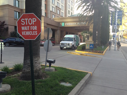
The Active Transportation Program petition

The Safe Routes to School National Partnership, along with a number of coalition partners, has offered a petition to increase the amount of funding for California’s Active Transportation Program (ATP). Information on the petition is at Safe Routes to School California and California Walks. What follows is not intended to discourage you from signing the petition. Rather, I’m suggesting that it doesn’t go far enough.

The petition asks for an increase of $100 million per year in funding. With the existing funding of about $120M, this would be just less than double the current funding, a not insignificant increase.

However, the amount is a tiny fraction the roughly $28 billion spent yearly on transportation in California. The majority of this expenditure is through Caltrans, and the majority of that is to expand the highway and road network. Those expenditures work directly against the goal of walkable, livable communities. Yes, expansions often now include some sidewalks and some bicycle facilities, but the preponderance of the project is not on these afterthoughts, but on increasing lane miles by extending and widening highways and roadways. Of the money expended on the road transportation system, about half comes from cities, counties and regions, about one-quarter from the federal government, and about one-quarter from the state. But because the state controls the federal and state portion, and state standards determine or strongly influence how the rest is spent, things must change at the state level.

Marketing for the petition includes: “Nearly $800 million in shovel-ready walking, bicycling and Safe Routes to School projects and programs were left unfunded in the first ATP awards cycle.” I imagine now that many agencies have started to figure out how ATP works, there will be even more applications this cycle, with an even bigger gap between applications and available funding. So would the addition of $100 million really make much of a difference? We have a long term deficit in active transportation of trillions of dollars. $100 million is not that significant.

The graphic below shows the portion of the state transportation budget (in red) going to the ATP program (in green) and which would be added (blue) if the petition resulted in supportive legislation. You may need to squint.

budget

Read More »

11th St bike fix

11th-St_no-bicyclesThe section of 11th Street between L St and Jazz Alley (the alley south of J St) is largely a pedestrian place, but it is also a bike route. For bikes wanting to enter from L St, there are two choices, using the sidewalk area to the right of the fenced seating, or riding the wrong way on the parking garage exit. It is signed against bicycles (see photo at right). And to be honest, it should be signed against bicycles in the sidewalk area because this walkway gets such heavy pedestrian traffic from the Capitol and all the retail and offices in this area.

11th-St-L-StSo, I’m proposing that a short protected bike lane be created that would carry bicyclists from L St to the open part of the pedestrian plaza. The roadway here is 27 feet wide, wide enough for two traffic lanes exiting the garage, and one contra-flow bike lane heading north. I’ve watched traffic exiting the parking garage, particularly at the end of the work day, and there is a lot of crazy, erratic driving, and almost continuously an attempt to form three lines of traffic and cut around other cars. A stripe of paint on the ground is not enough. There must be either delineators or a curb (asphalt or concrete) separating motor vehicles from bicyclists. The Google maps at right shows the general setting.

Below is a graphic showing how the traffic lanes and the contraflow bike lane would be installed. Southbound bicycle traffic would use the left hand of the two traffic lanes, which could be marked with a sharrow.

11th-St

N Street bike route to cycle track

Unknown, or unnoticed, by many people, there is a bike route along N Street on the sidewalks. The route is well-signed from 8th St, where it crosses over from the south side to the north side of N Street, to 12th Street. The route extends east along Capitol Park to 15th Street, and I believe it also extends west to 3rd Street, though it is not well signed at these ends. On the City of Sacramento bikeways map, the route is shown on both sides of N Street, as “Existing Off-street (wide sidewalk).”

The bike route allows bi-directional travel along N Street, which would otherwise not be possible. The city has recognized that N Street is a significant barrier to east-west bicycling.

Read More »

Curtis Village to City College bridge starts

Work has started on the bridge that will connect Curtis Village to Sacramento City College over the Union Pacific railroad right-of-way. The bridge supports on the Curtis Village side have been installed. I did not see any signs of work yet on the section over the tracks nor on the west side at the light rail station and campus. The bridge will be usable by bicyclists, though I am not sure whether the design really addresses bicyclists. The paucity of east-west routes over the rail and light rail corridor means that both bicyclists and walkers have rather unpleasant routes to choose from, so this will be a great improvement. The Sutterville Road bridge, though it has sidewalks and even a narrow bike lane, is a very unpleasant place to be due to the high speed traffic and poor visibility.

update on I Street

"bicycles must turn right" sign, I Street between 6th and 5th
“bicycles must turn right” sign, I Street between 6th and 5th

I wrote previously about the The I Street Mess. A small change has taken place here, with a new sign that says “Bicycles Must Turn Right” on the bike lane midway between 6th and 5th. Basically, this is a warning to bicyclists who missed the “Thru Bikes Merge Left” sign at the beginning of the block that they are truly screwed. By this point, bicyclist will have a very hard time merging across four lanes of high speed traffic to reach the left side bike lane that takes one to Old Sacramento or 3rd Street. At a minimum, the warnings need to occur earlier, in the block between 7th and 6th. Better yet would be slowing the traffic on I Street so that a bicyclist could actually maneuver through the traffic lanes. Best would be an alternate route for bicyclists who don’t wish to ride vehicularly, that avoids the I Street Mess completely.

14 foot lanes

There has been a discussion on the Association for Pedestrian and Bicyclist Professionals (APBP) listserv for the last two weeks on what to do with an outside lane of 14 feet (without on-street parking), particularly when there is a seam between the asphalt pavement and the gutter pan. Several people encouraged the use of narrow, substandard bike lanes in an effort to get something on the street, rather than using sharrows in the wide lane, or just leaving the lane unmarked. I believe we need to be very careful to not create “bike lanes at any cost,” and to carefully consider the actual roadway conditions before specifying anything that does not meet or exceed standards. The diagrams below are from the NACTO Urban Bikeway Design Guide. The first shows a high quality bike lane adjacent to a curb; the second one shows sharrows rather than a bike lane where there is not sufficient roadways width.

bike lane adjacent to curb (right side): NACTO Urban Bikeway Design Guide

shared lane markings adjacent to curb (left side); NACTO Urban Bikeway Design Guide

Read More »

Protected Intersections

When I posted on the North 12th Street Complete Street Project, I expressed concern about how the  cycle track to the north would transition to the bike lane to the south, and how bicyclists northbound would access the cycle track. On Wednesday I attended the project open house at City Hall. Preliminary designs presented by the contractor Echelon Transportation Group indicate one possible design for the intersection of 12th Street and C Street, a protected intersection. These conceptual design drawings are not yet available on the North 12th website, so I don’t have a drawing to share here. Comments from the open house and online will be used to revise the concepts, and they should then be available on the website for further review and comment.

The protected intersection is a design new to the United States, and so far not built anywhere in its entirety. The design is fairly common in bicycling friendly countries in Europe. The Protected Intersections for Bicyclists website provides a great video showing how the design works by providing a higher level of safety for bicyclists and pedestrians without much impact on motor vehicles. The design has not yet been included in the NACTO Urban Bikeway Design Guide, but I would guess it soon will be.

protected intersection

The diagram at right shows the general outline of a protected intersection. The intersection at 12th and C would look like the right half of the diagram on the west side, with the almond shaped corner medians, but would not look like the left half on the east side. Bicyclists heading south out of the cycle track would either continue south in the bike lane or use the protected intersection to turn east and then continue south on lower traffic streets. Bicyclists coming from the east would use the protected intersection to get to the west side and the cycle track.

Active Transportation Program (ATP) in region

This is not fresh news, but I just realized that I had not posted about grants in the Sacramento region under the Active Transportation Program cycle 1 awards in 2014.

Regional grants from the statewide program:

  • PLA, Roseville, Downtown Roseville Class 1 Trails, $2,547K
  • SAC, Elk Grove, Lower Laguna Creek Open Space Preserve Trail, $1,778K
  • SAC, Sacramento County, Howe Ave Sidewalk Infill and Bike Lane Improvements, $1,853K
  • SAC, San Juan USD, SRTS, $250K
  • YOL, Davis, SRTS Program, $562K
  • YOL, Woodland, 2014 SRTS, $539K
  • YUB, Marysville, SRTS Project & Programs, $489K

SACOG region grants:

  • ELD, El Dorado County Transportation Commission, Western Slope Bicycle Travel Opportunities Map $50K
  • PLA, City of Auburn, Nevada Street Pedestrian & Bicycle Facilities $799K
  • PLA, City of Colfax, North Main Street Bike Route Project $264K
  • SAC, City of Galt, South Galt Safe Routes to Schools $1,800K
  • SAC, City of Rancho Cordova, Mather Rails to Trails Project $2,235K
  • SAC, Sacramento County, El Camino Avenue Phase 2 – Street and Sidewalk Improvements $1,692K
  • SAC, City of Folsom, Oak Parkway Trail Undercrossing and Johnny Cash Trail Connection Project $992K
  • SUT, City of Yuba City, Franklin Road Improvements $313K
  • YOL, City of West Sacramento, Citywide Bike Lane Gap Closures $525K
  • YUB, Yuba County, Ella Elementary School Safe Routes to School Project $1,195K

There are also three projects on the SACOG contingency list.

At the other end of the bike lane

bike-lane-symbol-farI have long wondered why so many people ride the wrong way in bike lanes. The common label for these bicyclists is “salmon,” probably from Portland, signifying they are swimming upstream against the current. Good for spawning salmon (and bears), bad for bicyclists. There are some evident reasons for wrong-way riding:

  1. The completely wrong but common misunderstanding that bicyclists should ride facing traffic. The origin of this is the “walk facing traffic if there is no sidewalk” rule. It doesn’t apply to bikes, but when teaching bicyclist education to youth, I often hear them mention this as something their parents have taught them. In fact, riding the wrong way is the most common bicyclist-caused source of crashes, though these are usually injury crashes and not fatal crashes.
  2. One way streets make it difficult to get where you are going, so many people ride the wrong way to get where they are going. Understandable, but wrong.

I’ve recently come to realize, however, that the common bike lane design fails to discourage wrong-way riding by not marking the end of the bike lane with a direction. The beginning, departing an intersection, is marked with the bicycle symbol and arrow, but the end, approaching an intersection is not. So a person entering the bike lane does not immediately realize they are going the wrong way. Once they do realize it, I think they often just continue along their way rather than changing course to ride with traffic.

The solution? Mark bike lanes at both the beginning and end. That way a person going the wrong way immediately sees that they are going the wrong way.

What is the downside? There may be some confusion induced between the dashed line message, which is that this is a merge area for the regular lane and the bike lane, and the bike lane symbol, which seems to indicate that the exclusive bike lane continues. I don’t see this as a stopper, but it is an issue to be addressed. It is possible that a different variation of the pavement marking could be used, but another symbol is probably not what is needed.

North 12th Street Complete Street Project

North12thSt-logoThe City of Sacramento is soliciting input on the North 12th Street Complete Street Project, the most significant portion of which would install a two-way cycletrack on the west side of 12th Street between the Hwy 160 bridge over the American River near Richards Blvd, and as far south as F Street.

The project should be compatible with and benefit from the Choice Neighborhoods Initiative Twin Rivers project which would revitalize the Twin Rivers Community Housing and the surrounding area. The January 2014 Final Transformation Plan is available from SHRA.  Though the plan does not go into great detail on streets and transportation, page 78 does provide a good overview of the changes and the relationship to 12th Street and other efforts in the River District and Railyards. In particular:

  • Richards Blvd would be realigned and extended east of 12th St
  • several streets intersecting 12th St would be reconfigured, particularly Bannon St
  • a potential SacRT light rail station near the redevelopment and Richards Blvd

There is also a City of Sacramento project to add sidewalks to the east side of 12th St between B St and Richards Blvd.

Read More »