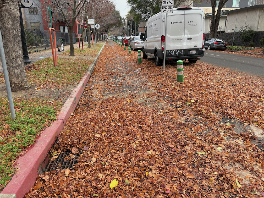
The City of Sacramento is not sweeping its separated bikeways, as it promised to do when it installed them. The separated bikeways, on I St, P St, Q St, 9th St, 10th St, 19th St, and 21st St have not been swept by the city. The city has a sweeper designed specifically for these bikeways. It may be broken down, or the city may be choosing not to sweep. Some of the bikeways are being swept by landscape maintenance services associated with adjacent properties, a few spots are being swept by individual owners or residents, and even the parks department is cleaning up, but not consistently.
Q St at 14th St, separated bikeway, not swept by city
In a few places that have heavier bicycle and scooter traffic, such as P St between 15th and 14th, the leaves have turned into leaf slime, which is extremely hazardous for anyone on two wheels. I’ve seen people almost spin out here, and I have as well.
Most people seem to have realized that the place for piled leaves is NOT in the bikeway, but in the adjacent buffer, and in some locations that buffer is labeled as such. But some people are still piling in the bikeway.
Regular bike lanes are an issue as well. Most are not swept. Dry leaves are sometimes swept away be motor vehicle traffic, but once they are wet, they don’t move. If there is motor vehicle traffic across or along the bike lane, such as approaching an intersection, the leaves are quickly turned into slime. Very slippery! Be cautious anywhere there are leaves.
Palm trees – ack!
And just in case you need to be reminded, palm trees and the fronds they drop are an ongoing hazard to people walking and bicycling. A single frond can block a sidewalk from use by anyone with a mobility device. A single frond can block a bikeway or bike lane, and can throw a bike rider off their bike. With every wind storm or heavy rain storm, palm trees drop huge numbers of fronds. Why do we continue to allow this hazard for walkers and bicyclists? In a few locations where they have historic value, such as Capitol Park, they might be justifiable. But nowhere else. They need to be removed!
Denver is implementing a unique approach to sidewalk maintenance (Denver’s Sidewalk Program). Rather than making the individual property owner responsible for sidewalk maintenance, the city will charge all property owners a fee which will be pooled city-wide to maintain or install sidewalks. It is a flat fee for most parcels, but with a progressive fee based on sidewalk footage for parcels with a lot of sidewalk.
The City of Sacramento, and most governments in California, make sidewalk maintenance the responsibility of individual property owners. State law allows this, though does not require it. You can see the results for yourself: broken sidewalks due to root heaves, discontinuous sidewalks, lack of ADA ramps. And the city and cities within the county and the county are not the worst in California. If you want to see truly horrible sidewalks, visit the City of Los Angeles, where root heaves from too narrow sidewalk buffers have broken or destroyed most sidewalks in the city.
Denver, recognizing that the model of individual property owners paying was not working, and under the threat of lawsuits, decided to take a different approach, making maintenance and installation the responsibility of all property owners. This is an immense improvement over the Sacramento and California model, though still falls short.
Sidewalks are a part of our transportation network, in fact are the most important part of that network. As such, they should be maintained, and gaps filled, as part of the regular transportation budget of cities, counties and the state. Making them a special case with special funding, or ignoring them completely, leads to a deteriorated and missing sidewalk network that actively discriminates against people who use the sidewalks to walk, roll, and, in some cases, bicycle. Every broken sidewalk and every missing sidewalk is a abject failure of the government to fulfill its responsibility to citizens to create a transportation system that serves everyone. Transportation engineers will always, if given the choice, prioritize motor vehicles over everyone and everything else, so we must compel them to meet their true responsibilities.
This Saturday, October 19, 2024, the River District Open Streets Festival will occur 12:00 PM to 4:00 PM at Mirasol Village, 400 Pipestem St, in the River District. Civic Thread is the primary host, working with a number of other partners and supporters. Registration is not required to participate, but is available on Eventbrite.
From the festival info page:
“Get ready to experience the heartbeat of our community at the Open Streets Festival in the vibrant River District this fall!
Join us for a day filled with family fun, local flair, and exciting activities for all ages. Discover live music, delicious food from local vendors, arts and crafts. Participate in interactive games, enjoy street performances, and explore the many pop-up shops that line the streets. It’s a perfect opportunity to connect with neighbors, celebrate our diverse culture, and support local businesses. Don’t miss out on this unforgettable event that brings everyone together in the heart of our beloved community.
This event is intended to showcase the power of community connection, healthy and active lifestyles, and the multitude of what the River District has to offer whether it be arts, food, or fun. There will be tables from community organizations, food vendors, and performances, along with interactive community activities such as a bike rodeo.”
Rancho Cordova and SABA also hosted an open street event last Saturday, which I hope to post about soon. Several other open streets events have happened recently, and more are in the planning stages, which is good to see after the long pause since the Sunday Street on Broadway event in 2017.
There are so many actions and possibilities for improving the efficient, equity, and safety of our transportation system that I can’t keep up with it all, and even nonprofits that have staff are unable to keep up. So, what’s going on? The list below is not in any priority order, but may give you ideas about what you would like to get involved in. It takes a village!
Items specific to City of Sacramento were in a previous post, while these items are about other locations, and/or applicable to all the cities and counties in the region.
Transportation funding in Sacramento County: Transportation sales tax measures in 2016 and 2022 failed, and a 2020 measure was withdrawn. Each measure was weak on active transportation and transit (and the sprawl developer sponsored ‘citizens initiative’ in 2022 was horrible), and also suffered from anti-tax sentiment in the county. There are three efforts to place a funding measure on the 2026 ballot, Sacramento Transit Authority (SacTA) new Measure A, SMART/Steinberg citizen measure for housing, active transportation, and roadway maintenance, and SacRT transit measure for City of Sacramento and Elk Grove. All of these are in early stages, not yet formalized. Sales taxes are regressive, making low-income people pay a much higher percentage of their income on these taxes, so efforts to identify other mechanisms are critically important.
Sacramento County Climate Action Plan: The county has delayed a climate action plan by years, going through a series of revisions that aren’t much better than the previous. Sacramento Climate Coalition and 350Sacramento have been the most active on this issue. It will take citizen pressure on staff and on the Board of Supervisors to ensure an effective plan.
Other climate action plans: Every city and county is required to come up with a climate action plan. I don’t know the status of plans other than City of Sacramento and Sacramento County.
SACOG 2025 Blueprint: SACOG is developing a new version of the MTP/SCS called Blueprint ‘Linking land use and transportation in the Sacramento region’. There is a constant tension between the desires of cities, in particular Sacramento, West Sacramento, and Davis, and the smaller cities and rural counties of the six county SACOG region, over what kinds of transportation investment to make. SACOG is required to come up with a plan that would reduce greenhouse gas emissions (GHG) by 19%, and the transportation policies and projects selected will make all the difference in whether the region has a chance for achieving that goal. Citizen pressure for infill and livable communities is required to counteract the small city and rural voices that just want money to continue doing what they’ve always done, which is encourage low density sprawl development with a motor-vehicle focused transportation network.
Caltrans District 3: While other entities are beginning to meet the public demand and legal requirements to reduce greenhouse gas emissions (GHG) by reducing vehicle miles traveled (VMT), and improve roadway safety, Caltrans District 3 is continuing to expand highway capacity, inducing travel demand and increasing GHG/VMT, and making it very hard for cities and counties to make their roadways that are state highways or that cross state highways (underpasses and overpasses) to improve safety. Caltrans headquarters has been unable to rein in District 3.
This list no doubt misses some important topics. Please suggest them in the comments.
In compiling this list, I realized that it was becoming very long, so I’m splitting it into two lists, the second on non-City of Sacramento to be posted shortly.
There are so many actions and possibilities for improving the efficient, equity, and safety of our transportation system that I can’t keep up with it all, and even nonprofits that have staff are unable to keep up. So, what’s going on? The list below is not in any priority order, but may give you ideas about what you would like to get involved in. It takes a village!
Streets for All Active Transportation Plan: This is ongoing. The neighborhood connections part of the plan, perhaps the most important element, will open a public input process in November, with two online workshops.
Work Zone and Event Detour Policy: This is ongoing, however, opposition in Public Works has delayed this policy by many months, and it will take public pressure to free it up.
Active Transportation Commission (SacATC): Though it has been pretty ineffective since founding in 2018, the addition of strong leaders to the commission and the notice of supportive city council members has opened the opportunity for real progress.
Vision Zero: Though the city committed to Vision Zero in 2017, the rate of traffic fatalities and severe injuries has increased every year since, because of the city’s unwillingness to take dramatic action, and the very very slow process of depending on grant funding to improve streets. The focus on corridors and inattention to intersections is also a flaw. The Vision Zero plan is being updated, but so far there has been no public involvement.
Speed limits: The city reduced speed limits in many school zones several years ago, on a few streets recently, and is working towards additional reductions under AB 43.
Emergency Declaration on Roadway Safety: Vice Mayor Caity Maple, Mayor Darrell Steinberg, and council member Karina Talamantes are sponsoring an emergency declaration on roadway safety, to address the epidemic (pandemic?) of traffic violence in the city. The initial proposal focused on ineffective traditional responses, but they seem open to more innovative and effective approaches.
Climate Action and Adaptation Plan: This plan, now part of the 2040 General Plan, set targets for walking, bicycling, and transit mode share, that were less ambitious than proposed in the Mayors Climate Action Plan, but nevertheless significant. Reaching these targets will require proactive changes to transportation funding allocation, street redesign, and implementation of quick-build projects.
Transportation Priorities Plan (TPP): This plan was adopted in 2022, to guide city investment and grant seeking based on objective criteria, rather than the whims of traffic engineers. Though the priorities could have been better weighted towards equity, active transportation, and climate action, it is nevertheless an immense improvement. Citizens will have to monitor the city’s decisions to ensure that the plan is followed, and improved over time.
Shared Mobility/Shared Rideables: The city has a shared rideables program which has resulted in a plethora of electric scooters in some parts of the city, and almost none in others, and almost no bike share at all, though we once had the second most successful bike share in the US. The city has chosen to let the market decide, the commercial companies, and has refused to consider city subsidy or a city program to ensure more widespread and equitable availability.
Quick-build: The active transportation community has requested that the city implement a quick-build program, with funding, that can respond quickly to crashes and traffic safety issues. Leadership has primarily been by Slow Down Sacramento. Though the city has discussed a program, they have so far refused to implement or fund a program.
Red light camera enforcement (no link because the city removed its page): The city participated in the county’s red light camera program, but when the county dropped the program, the city did as well, and so far as is known, has no plans to develop their own program. Red light running is epidemic (pandemic?) in Sacramento, and elsewhere, and there must be an automated enforcement program, with equity guardrails, to address this traffic violence issue.
Daylighting: State law (AB 413) prohibits parking with 20 feet of intersections, in order to increase visibility between drivers and people walking. The city has not said whether it will enforce this law, nor whether it will add signing or red curbs to communicate it to drivers. So of the benefits of daylighting can also be achieved through temporary (quick-build) or permanent curb extensions.
Speed camera enforcement: The city is not part of the speed camera enforcement pilot program (though to its credit, it asked to be). The city should continue to ask to be part of the pilot program, and to fully participate when the program becomes permanent.
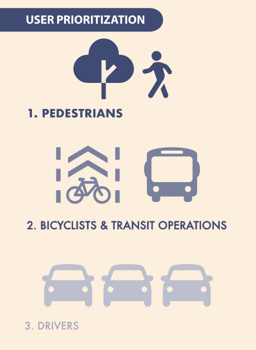
The 2040 General Plan: The plan sets a new vision for mode priority in the city (graphic below). This is a seismic shift in priorities, and will be resisted by many city staff, so it will take citizen pressure to ensure that it is followed.
User Prioritization from City of Sacramento 2040 General Plan
This list no doubt misses some important topics. Please suggest them in the comments. The next post will include some actions that are applicable to City of Sacramento, but also to other cities, the county, and the region.
Caltrans and Yolo County Transportation District are proposing to widen a section of Interstate 80 from Sacramento to the Yolo/Solano county line, a project called Yolo 80. This is not just a future project, subject to funding shortfalls and lawsuits, but is actually underway, as Caltrans illegally spends funds for highway maintenance on highway widening. I have written a number of posts on Yolo 80 and managed lanes, but today is just about the bike path that parallels Interstate 80 from the west edge of West Sacramento to Davis.
I am not a commuter or regular rider on the causeway path, but I do average riding it about once a week (I like concerts and beer and Mishka’s tea), and have been doing so for about 13 years.
I had hoped to observe bicyclists reacting to the signal, but unfortunately there were no bicyclists. Despite the city devoting much of the street right-of-way to bike lanes (not protected, on only sometimes buffered), it appears that no one is riding their bicycle on Broadway. I’m not surprised. Broadway continue to be an unpleasant place for bicyclists and walkers, and regular bike lanes are unlikely to change that.
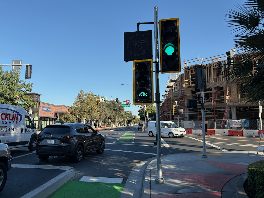
The last post I had noted that there was a required beg button for bicyclists to trigger the bike signal, but had failed to look up and notice that there was a complete set of regular signal, bike signal, and blank-out no-right-turn sign on the same post. It looks like:
Broadway eastbound at Land Park Dr, signal, bike signal, blank-out no right turn
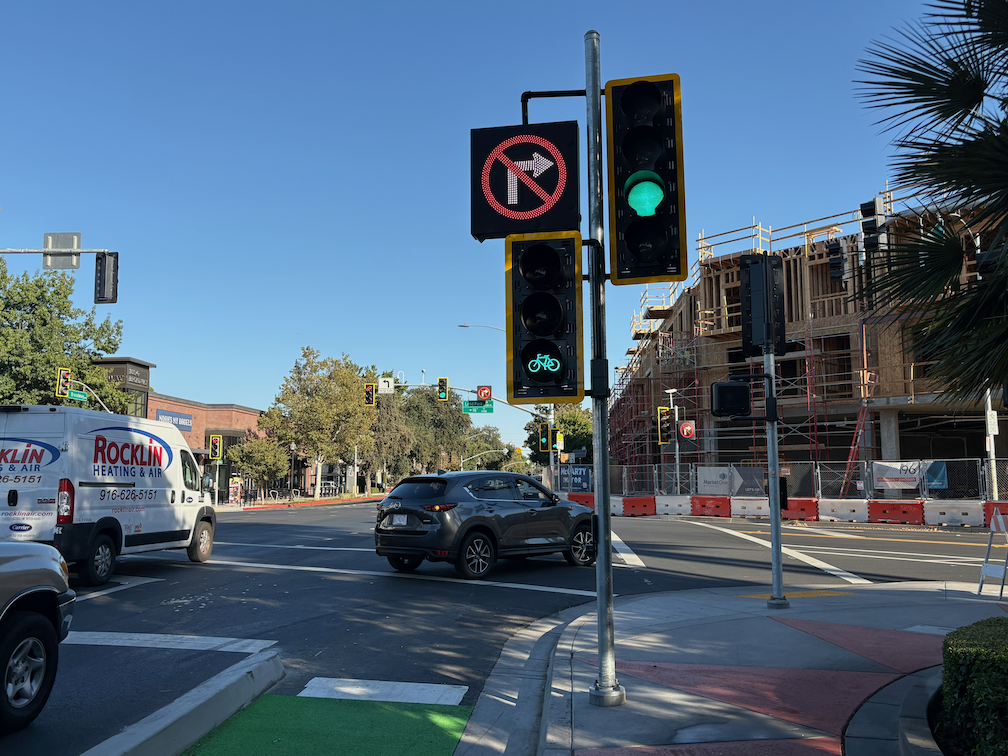
For those unfamiliar with the blank-out signs, which are relatively uncommon in the city, it illuminates when turns are prohibited, and is blank when not prohibited. See photo below for the blank-out phase.
This signal array is definitely mis-communicating to drivers. When the bicycle signal is on, the no-right-turn sign should be on, and the regular signal red. This is mounted close to the right hand turn lane, and drivers see it as applying to that lane.
Most of the time, it is necessary to press the pedestrian beg button to trigger the bike signal. But then sometimes it is triggered without any press, and not due to the presence of bicyclists, as there were no bicyclists. Most signal cycles the bike signal remains red.
When the bike signal is on, there is a period of time when the no-right-turn sign is not on (blanked out), as below.
Broadway eastbound at Land Park Dr, signal, bike signal, blanked-out no-right-turn
Do drivers follow the no-right-turn sign? In an hour of observation, I did not see one driver follow the sign. Every driver turned across the no-right-turn sign and across the green bike signal. Every. Though I did not observe it at this time, I have experienced drivers yelling at me, and other bicyclists have reported being yelled at, by drivers who think they have the right of way and wonder why bicyclists are proceeding and interfering with cars. The photo below shows just one of about 70 drivers who turned against the no-right-turn sign.
Broadway eastbound at Land Park Dr, driver turning against no-right-turn sign
Solutions
The regular signal should remain red while the bike signal is green. The placement of this signal is interpreted by drivers as applying to the right hand turn lane, so it must be red.
The bike signal must have an exclusive phase where all other vehicle movements are prohibited. A properly designed intersection with a properly designed signal system probably would not need an exclusive phase, but this is NOT a properly designed intersection and NOT a properly designed signal system.
The pedestrian beg button should be removed from the bike lane, and automatic detection of bicyclists installed. The city knows how to do this, and has done it at a few other intersections, but chose not to here.
Bicyclists will be fatally or severely injured here, and the cause of the crash will be mis-designed roadways, for which city engineers are directly responsible. Drivers are just responding to a mis-designed roadway, the guilty party is the traffic engineers.
The design document for Broadway Complete Streets, and as built, has a through lane, a dedicated left hand turn lane, and a dedicated right hand turn lane. This right hand turn lane is the source of the conflict, the source of the danger. The roadway as built prioritizes motor vehicle throughput over safety.
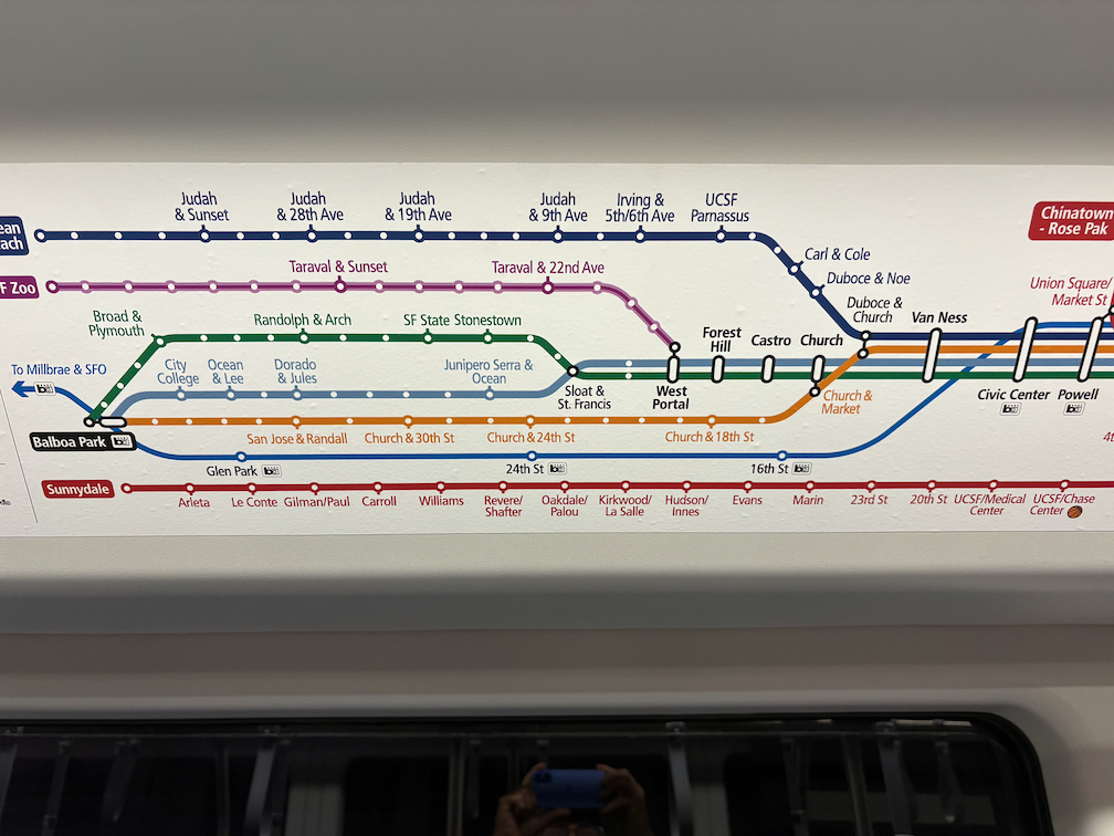
My last major trip for the Week Without Driving was a trip to San Francisco.
Friday, I walked from a transportation safety meeting to Sacramento Valley Station, and caught Capitol Corridor train to Richmond, then transferred to BART into San Francisco Embarcadero Station, and walked to Trader Joe’s and then to the Hostelling International hostel near Union Square. That evening I walked to San Francisco Playhouse to see The Play that Goes Wrong, only two blocks away, which is why I stay at that hostel when I’m seeing a play.
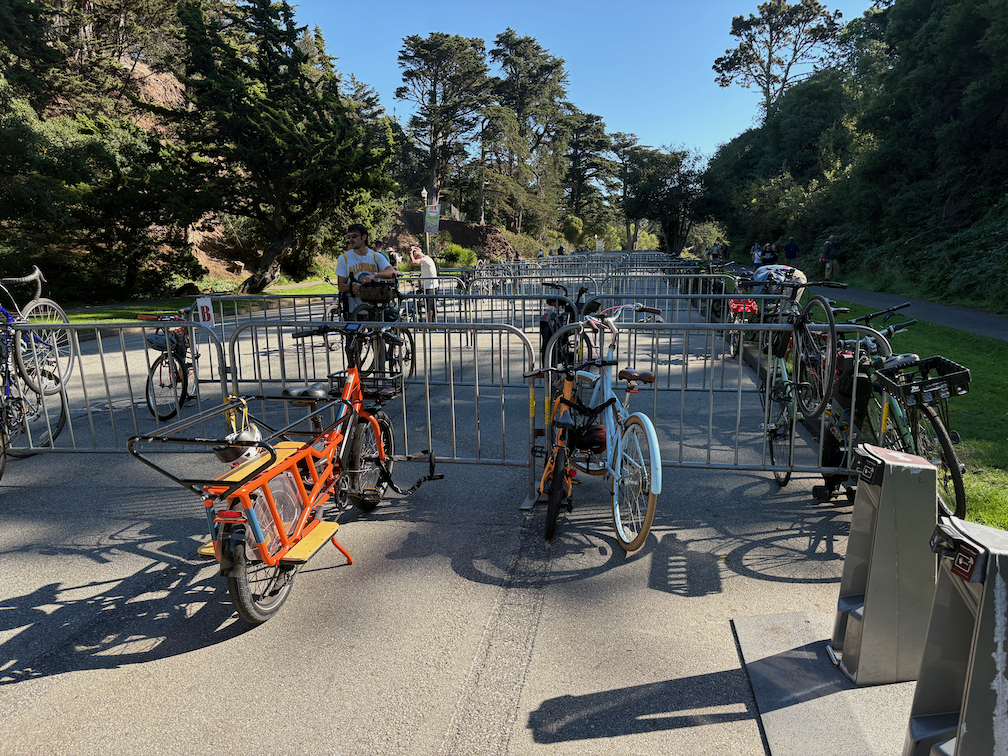
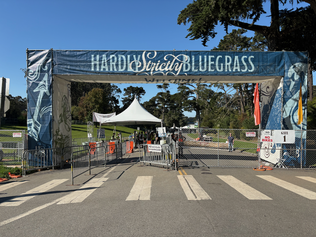
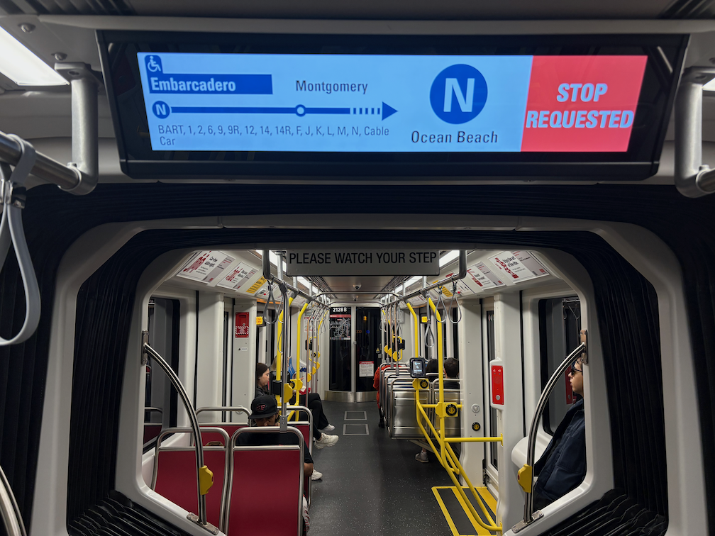
Saturday morning I walked to the Ferry Building farmers market to grab a few picnic items, then took Muni Metro N Judah light rail to 9th & Irving. From there I walked into Golden Gate Park and to Hardly Strictly Bluegrass (HSB), a three day free festival (I missed the first day due to the transportation meeting) that I’ve attended seven times since 2010 (the festival is 24 years old). I realized sitting on the grass that I really wanted a lightweight folding chair to Sunday, and other uses, so I took two Muni buses to Sports Basement in the Presidio, bought the chair, and then one bus back to Union Square area and the hostel.
Evening, I went to a contra dance in Oakland, Circle Left. Short walk to BART, BART from Powell Station to 19th St Oakland, walk to the dance center. I didn’t last the entire dance, because a hot day in the sun and dancing at the festival left me drained. Walk and BART and short walk back to the hostel.
Sunday I again took Muni Metro N Judah to 9th & Irving, and walked to the Japanese Tea Garden, my favorite part of Golden Gate Park (among many), spent some while just being, and then had Hojicha tea. From there, a walk along JFK Promenade to HSB. The promenade is a long now car-fee route in the park, one of the best outdoor spaces in the city. The day was slightly less hot, but no less sunny, so in between main stage performances, I wandered to shadier stages (six stages total). The closing act by Emmylou Harris draws the biggest crowd of the festival, and of course I joined the many dancers on the grass to the left of the stage. Everything over, I walked out of the park and caught N Judah back to Union Square to pick up my travel pack left at the hostel, then BART to Richmond.
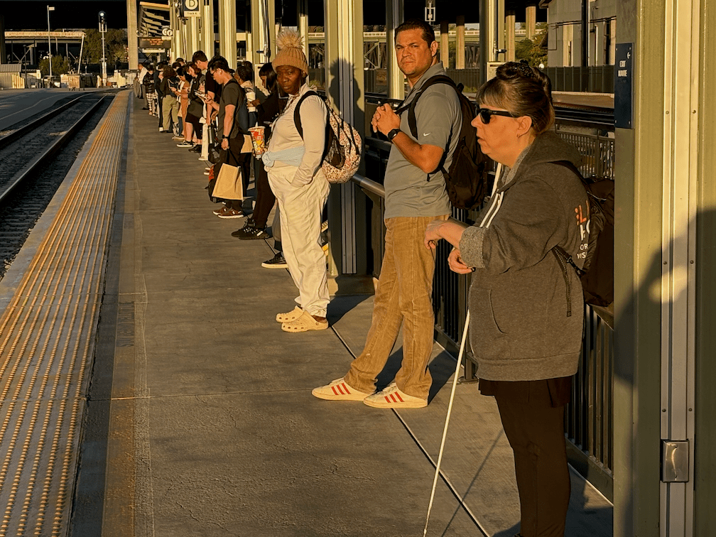
I missed the Capitol Corridor train that I intended to catch, so had to wait for the last. For an unknown reason, this last train was scheduled for an hour later than normal. The last train is often delayed to accommodate people attending the 49er’s game, or other major sports events, but the game on Sunday was an afternoon game, so the delay made no sense. And then the train was late. The plus was that I met and talked with several people on the platform who had also attended HSB. The train got me home after midnight, and I walked back home (there is no light rail service after 11:00 PM).
I do tend to cram in as many activities as possible when I take trips to San Francisco and the Bay Area, and this weekend was no exception. A big part of what enables this is the great transit system in the Bay Area. Not perfect, but great. Could I have done all this with a car? No, because I’d have spent so much of my time looking for parking that I’d have missed other activities, and paid more for parking than I spent on the entire trip travel.
I plan almost all of the travel with the Transit App, and pay for all of my transit in the Bay Area with a Clipper Card (on my watch). Capitol Corridor travel I buy in the Amtrak app, which is now easier to use than the website.
These are my three big trips during the Week Without Driving (a trip to San Rafael, a trip to Fair Oaks). I did a lot of bicycling and walking as well. I am not a person who has to walk, bicycle and transit. I do it by choice. Though having a car would probably eat up so much of my income that I’d likely end up living in my car. That is not a joke. If you look at areas in Sacramento where unhoused people are living, you will often see high value cars. I suspect paying for those very expensive cars is what pushed many people over the edge into homelessness.
Dan Allison, author of this blog, took a trip to San Rafael, California, in north bay Marin County, on Monday of Week Without Driving. To be transparent, I have been car-free for over 13 years, and car-light for about 7 years before that, so a trip on bicycle and public transportation is just the way I live life, not an exploration of the challenge that people who can’t drive face. My income is lower middle income, so I have enough money to travel, at least locally. I went to San Rafael to retrieve my phone charger and battery pack that I’d left on a Marin Transit bus last Wednesday. It took three days for Marin Transit to find the item and get it to lost and found. It was entertaining, and sad, to watch the included AirTag travel around on multiple bus routes. AirTags are bluetooth, so only report when they are close to a modern iPhone, but they do keep showing up in new locations.
So, the Monday trip:
bicycle from home to Sacramento Valley Station
Capitol Corridor train from Sacramento Valley Station to Richmond Station, $22.95
BART from Richmond to El Cerrito del Norte, $0.85
Golden Gate Transit bus 580 from El Cerrito del Norte to San Rafael Transit Center, $3.50
bicycle to a local coffee shop, where I worked on Week Without Driving communication
bicycle to Sprouts Farmers Market for lunch supplies
bicycle to Larkspur Ferry
Golden Gate Larkspur Ferry to San Francisco, $7
bicycle to San Francisco Bay Ferry gate G1
San Francisco Bay Ferry to Oakland Ferry, $2.30
bicycle to Oakland Jack London Station
Capitol Corridor from Oakland to Sacramento, $24.65
bicycle from Sacramento Valley Station to home
All of the public transportation was using my senior Clipper Card, on my watch. Capitol Corridor train travel was pre-purchased tickets through the app. The total was $61.25, which is rather expensive for a none day trip, but is quite a bit less than I would have spent driving. At about 83 miles there, and about 105 miles back, using the IRS rate of $0.67 per mile, driving would have cost $126. Plus $17.25 for Golden Gate Bridge and Carquinez Bridge tolls. Most people think only about gas costs, or charging costs, and forget about depreciation, insurance, maintenance, parking, and tolls.
Travel time is hard to compare, since I made so many stops along the way, and did not travel by the most direct route. Looking at the simpler Sacramento to San Rafael trip, driving would be 1 hour 20 minutes, whereas I spent about 2 hours 20 minutes on public transportation.
This is a trip that I’ve taken many times, so there was very little planning involved, and in fact I changed my plans for the leg back home several times on the fly, without problems. Less familiar trips would take more planning.
A few photos from my trip are below, but many parts are missing. I’m not used to documenting my public transportation travels, and even less for selfies.
Week Without Driving 2024 will be held nationally, and in the Sacramento region, September 30 – October 6. Mark those dates on your calendar and prepare to participate!
A planning committee is meeting once a week to refine details and promotion, so expect to see that showing up shortly. SacRT will be offering free rides to participants on select days.