Halloween streets?

Halloween is traditionally one of the most dangerous days/nights of the year for children, due to traffic violence.

Last year I was in Davis by chance for their downtown kids-oriented Halloween celebration, Treat Trail. The sidewalks are filled with kids in costumes, and their parents sometimes too. Local businesses give out candy and other treats. I have never seen such a community oriented celebration, not just of Halloween, but of Davis. Several things make this event safe. It is in the afternoon, not in the dark. The mass of kids and families makes everyone pay attention, including drivers. Drivers in Davis are much more respectful of people walking (and bicycling) than are drivers in Sacramento.

Yes, I realize Halloween, on Saturday, October 31, is only two days away, too late to organize something for this year. But since I forgot to post in a timely manner, better now so that I can re-post it next year.
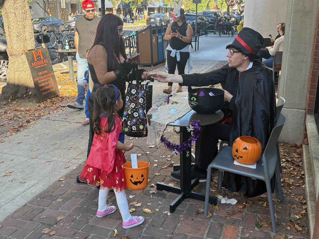
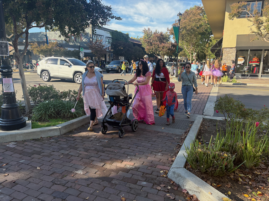
In Sacramento, many families won’t let their kids go out, for fear of traffic violence. There are organized ‘trunk-or-treat’ events where people give out candy from the trunk of their cars, which is as far from the spirit of Halloween as I can imagine, and a sure sign of motor vehicle hegemony, that it is only safe to be around motor vehicles when they are not moving.

Could Sacramento do something like Davis? Yes, but only on streets closed to cars. The danger from drivers is just too great on streets open to cars in Sacramento. Where could this happen? It could happen anywhere that the neighbors or businesses got a permit and bought or rented barriers, and paid for police overtime.

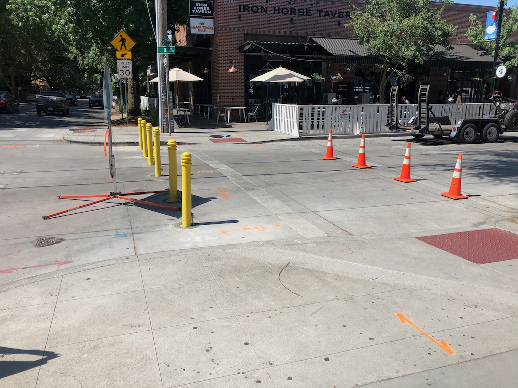
But there are two locations in central city Sacramento where the streets are already set up to be closed to cars, and open to trick-or-treat, R Street corridor, and the 20th Street & K Street farmers market area, where the streets can be closed with bollards. Bollard bases have been installed at a number of intersections, and at many of these, the bollards are waiting in bollard corrals to be placed. The photo below shows bollards on R Street at 15th Street, during the pandemic closure of R Street, but the bollard bases and bollards are still being used for special events. What better special event than a Halloween street for kids?

I don’t know which blocks would provide the best experience for kids and business owners. It requires a certain density of supportive local businesses to be successful.

Just showing up today, the post ‘Map: Where are San Francisco’s Halloween events and car-free streets?‘ on Mission Local. Note that searching for ‘halloween car free streets sacramento’ turns up nothing. There are events in parking lots, and parks, and community locations, but nothing on streets. Absolutely nothing.

And, Why Halloween Can Be Dangerous in America (Bloomberg 2026-10-28).
Midtown 20th Street & K Street

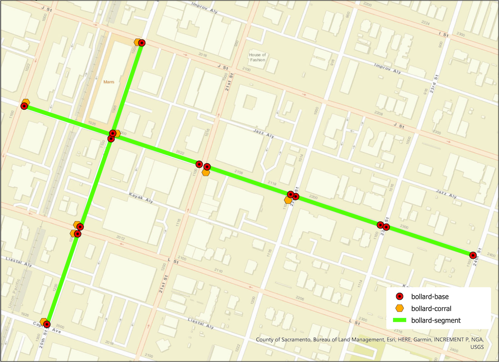
The map below (pdf) shows the bollard base ‘fences’ at intersections, the bollard ‘corrals’ where bollards are stored when not in use, and the ‘bollard streets’ that can be easily closed to motor vehicles and opened to people walking, including kids. The streets segments are 20th Street between Capitol Avenue and L Street, L Street and K Street, and K Street and J Street; and K Street between 19th Street and 21st Street, 21st Street and 22nd Street, 22nd Street and 23rd Street, and 23rd Street to 24th Street. The Saturday Midtown Farmers Market uses 20th Street between Capitol Avenue and K Street (to north to I Street), and K Street between 19th Street and 21st Street. I have not been the eastern segments being used, but they may be.
R Street Corridor

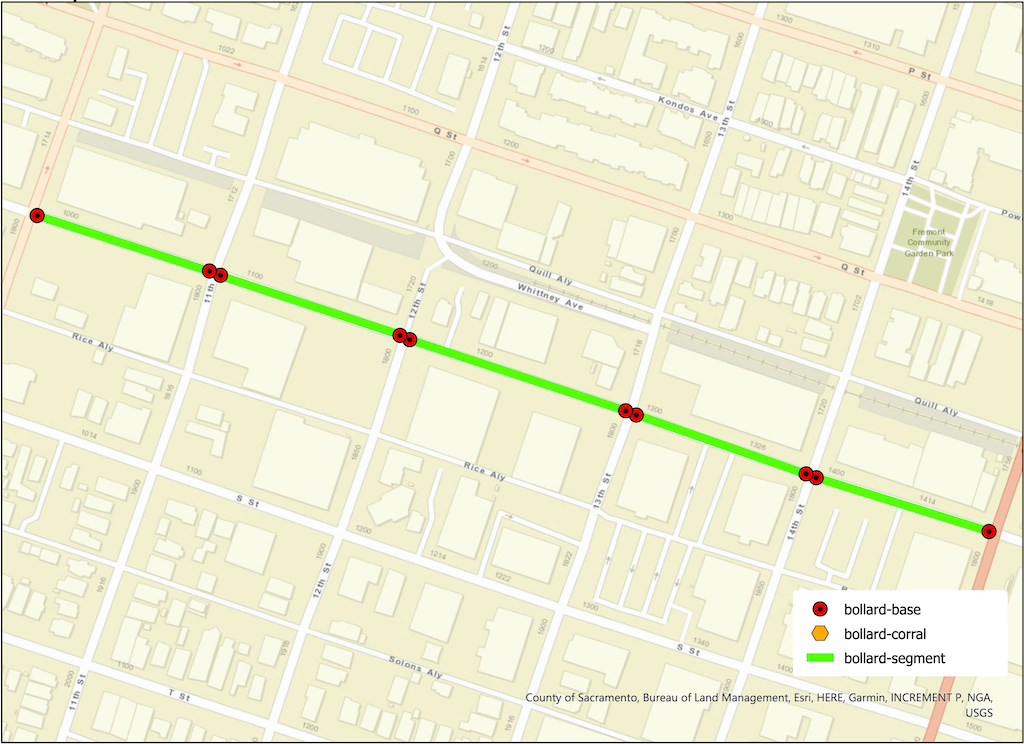
The map below (pdf) shows the bollard base ‘fences’ at intersections, and the ‘bollard streets’ that can be easily closed to motor vehicles and opened to people walking, including kids. There are five segments from 10th Street to 15th Street. The cross-sections do not have bollard base ‘fences’. There are no ‘bollard corrals’ for storage, so they must be stored elsewhere. I have seen several of these segments in use for night market, craft markets, and other community events.
River District Open Streets October 19

This Saturday, October 19, 2024, the River District Open Streets Festival will occur 12:00 PM to 4:00 PM at Mirasol Village, 400 Pipestem St, in the River District. Civic Thread is the primary host, working with a number of other partners and supporters. Registration is not required to participate, but is available on Eventbrite.

From the festival info page:

“Get ready to experience the heartbeat of our community at the Open Streets Festival in the vibrant River District this fall!

Join us for a day filled with family fun, local flair, and exciting activities for all ages. Discover live music, delicious food from local vendors, arts and crafts. Participate in interactive games, enjoy street performances, and explore the many pop-up shops that line the streets. It’s a perfect opportunity to connect with neighbors, celebrate our diverse culture, and support local businesses. Don’t miss out on this unforgettable event that brings everyone together in the heart of our beloved community.

This event is intended to showcase the power of community connection, healthy and active lifestyles, and the multitude of what the River District has to offer whether it be arts, food, or fun. There will be tables from community organizations, food vendors, and performances, along with interactive community activities such as a bike rodeo.”

Rancho Cordova and SABA also hosted an open street event last Saturday, which I hope to post about soon. Several other open streets events have happened recently, and more are in the planning stages, which is good to see after the long pause since the Sunday Street on Broadway event in 2017.

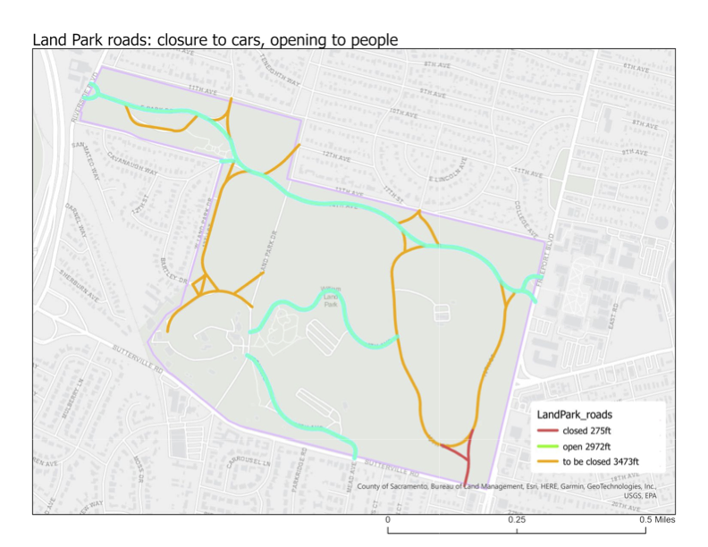
Land Park open (car free) roads?

With the exciting news that the closure of a part of JFK Drive in Golden Gate Park will remain permanently closed to private vehicles. This closure was made to provide safe open space during the pandemic, and is only a small portion of the roads in the park. Most of the people who live in San Francisco support this closure to cars (opening to walkers and bicyclists), and most of the people who visit the park from elsewhere (which includes me) also support.

People have started talking about Land Park in Sacramento. I was certainly not the first. This has been an ongoing conversation among advocates for walking and bicycling for years, but it never turned into a movement. Maybe today is the day.

Below is my (modest) proposal for closing some of the roads in Land Park to private vehicles (pdf). There is a small existing closure, of the roadway in from the southeast corner of the park. It has gates that are permeable to bicyclists.

My proposal closes about 53% of the roads in the park, but leaves open roads that access important points such as Fairytale Town and the golf course (if that is important). It also leaves open an east-west route through the park, with ample parking along the roadside, for those who need vehicle access. People who drive are most likely to access the park from Riverside Drive, Land Park Drive, and Freeport Blvd; all those access points remain open.

Of course the use of the term ‘closed to cars’ is really an inversion. Roads that are closed to private vehicles are by nature open to walkers and bicyclists, and so are really ‘open’ to people.

So, what do you think? Constructive comments are always welcome.

big smiles at Sunday Street on Broadway

Sacramento’s first open street event* took place on Sunday, Sunday Street on Broadway.  

Broadway was closed to cars and open to people from 8 to noon. The route was on Broadway from Riverside east to 26th St, jogged down to 2nd Ave, and then ended again at Broadway. People were wondering how this would work in Sacramento, the first time, and in a place that is pretty car-centric. Well it worked great! A lot of people came out. I’m sure the city will have an estimate, but the initial answer is, a lot.

If success is measured by smiles, and it should be, this event was a great success. People of all ages were there, people from the neighborhood and the region. A lot of people were bicycling, but a lot were walking, and using other wheeled devices. Slide tricycles, which I didn’t even realize were a thing in Sacramento, were common.

Sacramento Area Bicycle Advocates (SABA) created a separated bikeway (protected bike lane) for people to experience, which attracted a lot of attention and generated a lot of discussion about the state of bicycling in Sacramento. Adjacent, WALKSacramento asked people to add their favorite places to walk to a chalk board, all of which were NOT car-dominated places. Some people prioritized how it felt to walk, others their destination. Ice cream was a popular theme. 

Outside food vendors were prohibited in order to highlight local restaurants. For those open, business was booming. Some places missed out, though, by not being open. I’d imagine as word gets around how well it works, food retail along future events will be open and prosperous. Many business owners just assume that most of their customers come by car, but places that encourage and activate walking and bicycling all have increased business. Vintage Bicycle Supply was open and crowded with people not even aware it existed, and fans of the CycleFest cruiser bikes. New Helvetia Brewing was quenching people’s thirst and hosting running clubs. There were a lot of sports and fitness vendors, showing people what they had to offer and just providing fun. The two hula hoop groups were particularly popular with kids, and there were chalk drawings everywhere. Sidewalk chalk may be the single most important tool available to the public for activating public spaces. 

SACOG and Social Bicycles were showing off the new bike share which opened just Thursday. I heard comments from a lot of people that they found the bikes easier to ride than they thought, and were looking forward to trying it out. [previous post riding the bike share.

The section along 26th St and 2nd Ave was much quieter, with a cluster of local businesses and organizations near the end at Broadway. It was also far cooler than Broadway, with all the street trees moderating the temperature about 10 degrees below Broadway. This was not only much appreciated by people, but points out that for the new Broadway to work for pedestrians and bicyclists, it is going to need to not only not lose many of the existing trees, but to really create a welcoming tree lined street. When I participated in the public meetings the last two years, I didn’t realize how important street trees would be. Since Broadway will be a vibrant commercial corridor, it may be that the big shade trees should be in the median, with less dense trees between the street and retail, so that the view of customers is not obstructed. Interesting design issues. 

Hope you had a fun time too! I’m looking forward to the next one. 

Photos on Flickr

* Though the county claims its Great Scott road closure is an open street event, it really does not meet the widely accepted definition of an open street.