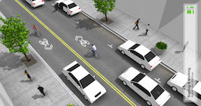
There has been a discussion on the Association for Pedestrian and Bicyclist Professionals (APBP) listserv for the last two weeks on what to do with an outside lane of 14 feet (without on-street parking), particularly when there is a seam between the asphalt pavement and the gutter pan. Several people encouraged the use of narrow, substandard bike lanes in an effort to get something on the street, rather than using sharrows in the wide lane, or just leaving the lane unmarked. I believe we need to be very careful to not create “bike lanes at any cost,” and to carefully consider the actual roadway conditions before specifying anything that does not meet or exceed standards. The diagrams below are from the NACTO Urban Bikeway Design Guide. The first shows a high quality bike lane adjacent to a curb; the second one shows sharrows rather than a bike lane where there is not sufficient roadways width.
bike lane adjacent to curb (right side): NACTO Urban Bikeway Design Guideshared lane markings adjacent to curb (left side); NACTO Urban Bikeway Design Guide
When I posted on the North 12th Street Complete Street Project, I expressed concern about how the cycle track to the north would transition to the bike lane to the south, and how bicyclists northbound would access the cycle track. On Wednesday I attended the project open house at City Hall. Preliminary designs presented by the contractor Echelon Transportation Group indicate one possible design for the intersection of 12th Street and C Street, a protected intersection. These conceptual design drawings are not yet available on the North 12th website, so I don’t have a drawing to share here. Comments from the open house and online will be used to revise the concepts, and they should then be available on the website for further review and comment.
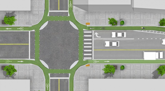
The protected intersection is a design new to the United States, and so far not built anywhere in its entirety. The design is fairly common in bicycling friendly countries in Europe. The Protected Intersections for Bicyclists website provides a great video showing how the design works by providing a higher level of safety for bicyclists and pedestrians without much impact on motor vehicles. The design has not yet been included in the NACTO Urban Bikeway Design Guide, but I would guess it soon will be.
protected intersection
The diagram at right shows the general outline of a protected intersection. The intersection at 12th and C would look like the right half of the diagram on the west side, with the almond shaped corner medians, but would not look like the left half on the east side. Bicyclists heading south out of the cycle track would either continue south in the bike lane or use the protected intersection to turn east and then continue south on lower traffic streets. Bicyclists coming from the east would use the protected intersection to get to the west side and the cycle track.
I have long wondered why so many people ride the wrong way in bike lanes. The common label for these bicyclists is “salmon,” probably from Portland, signifying they are swimming upstream against the current. Good for spawning salmon (and bears), bad for bicyclists. There are some evident reasons for wrong-way riding:
The completely wrong but common misunderstanding that bicyclists should ride facing traffic. The origin of this is the “walk facing traffic if there is no sidewalk” rule. It doesn’t apply to bikes, but when teaching bicyclist education to youth, I often hear them mention this as something their parents have taught them. In fact, riding the wrong way is the most common bicyclist-caused source of crashes, though these are usually injury crashes and not fatal crashes.
One way streets make it difficult to get where you are going, so many people ride the wrong way to get where they are going. Understandable, but wrong.
I’ve recently come to realize, however, that the common bike lane design fails to discourage wrong-way riding by not marking the end of the bike lane with a direction. The beginning, departing an intersection, is marked with the bicycle symbol and arrow, but the end, approaching an intersection is not. So a person entering the bike lane does not immediately realize they are going the wrong way. Once they do realize it, I think they often just continue along their way rather than changing course to ride with traffic.
The solution? Mark bike lanes at both the beginning and end. That way a person going the wrong way immediately sees that they are going the wrong way.
What is the downside? There may be some confusion induced between the dashed line message, which is that this is a merge area for the regular lane and the bike lane, and the bike lane symbol, which seems to indicate that the exclusive bike lane continues. I don’t see this as a stopper, but it is an issue to be addressed. It is possible that a different variation of the pavement marking could be used, but another symbol is probably not what is needed.
The City of Sacramento is soliciting input on the North 12th Street Complete Street Project, the most significant portion of which would install a two-way cycletrack on the west side of 12th Street between the Hwy 160 bridge over the American River near Richards Blvd, and as far south as F Street.
The project should be compatible with and benefit from the Choice Neighborhoods Initiative Twin Rivers project which would revitalize the Twin Rivers Community Housing and the surrounding area. The January 2014 Final Transformation Plan is available from SHRA. Though the plan does not go into great detail on streets and transportation, page 78 does provide a good overview of the changes and the relationship to 12th Street and other efforts in the River District and Railyards. In particular:
Richards Blvd would be realigned and extended east of 12th St
several streets intersecting 12th St would be reconfigured, particularly Bannon St
a potential SacRT light rail station near the redevelopment and Richards Blvd
There is also a City of Sacramento project to add sidewalks to the east side of 12th St between B St and Richards Blvd.
I have noticed, as I ride around the Sacramento region, that about 90% of the e-bikes are being ridden by young, apparently healthy males. Of course it is true that not all disabilities are apparent, and that some of these e-bikes may be the perfect solution a person with a disability. However, I wonder at the user profile. Why are young, healthy males riding e-bikes when they could be riding regular bikes? And why am I not seeing more elderly, and more visibly disabled, people riding them? It seems strange to me. Just saying…
There is a new bike corral in Sacramento, on the north side of L Street between 19th and 18th, in front of Ginger Elizabeth Chocolates. This is one of the two bike corral locations set in the city’s bike corral program (linked below) Phase II effort, with the other being some racks in a large area set aside to calm traffic at the intersection of N Street and Folsom Blvd. Phase I includes the two corrals at Insight Coffee on 8th Street, and Pangaea Two Brews on Franklin Blvd.
This corral, and the two Phase I corrals use the Park-a-Bike Varsity rack, which is becoming somewhat of a standard in the Sacramento region. The N Street corral uses more traditional but effective U-racks.
Please stop by these locations and visit the businesses which have requested the corrals!
Six more locations were tentatively identified but have not been officially selected yet.
I Street entrance to Old Sacramento, from Envision Sacramento
The topic uses the photo at right to illustrate the question. What you can’t see in the photo is that behind the photographer and across 3rd Street (to the left), pedestrian access is on the south side, but to the west, it is on the north side.
Comments include a number about the aesthetics of this entrance to Old Sacramento, including the having a dark freeway under crossing as the main route into the one of the highlights of Sacramento, with poor signing for motor vehicle drivers, bicyclists, and pedestrians. A surprising (to me) number of comments, though, were about the transportation aspects, that it is really not safe for bicyclists or pedestrians to use this entrance, even if they know it is there, and the paucity of other options. I think it is clear that the commenters agreed that the way in which Interstate 5 severed the connections between downtown and Old Sacramento is a major issue.
A gallery of photos shows some of the specific problems at this location.
A “green wave” is a traffic signal sequence set so that vehicles will encounter green lights for some distance, so long as they are traveling at the selected speed. A green wave can also be set for bicycle speeds, though it very rarely has been, and never in Sacramento.
To some degree, all signals are set this way, though the degree and distance of sequencing varies widely. Many of the east-west streets in the Sacramento grid have signals set for motor vehicles, and when traffic is not congested, it may be possible to go all the way across downtown and midtown on green lights, for example on J Street. Very few north-south streets are set this way, I can think of only the 15th & 16th couplet, and the 9th & 10th couplet. At intersections with the east-west couplets, these north-south couplets seem to have their green wave broken. Only if the grid spacing and the selected speed calculate out is it possible to have a green wave in all directions. Sadly, many signal sequences in the Sacramento region are set above the posted speed limit, encouraging drivers to speed so that they make all lights.
M Street bike routeAs I said yesterday, I choose primarily two-way, two-lane streets to walk on, because they offer a quieter and calmer place to enjoy walking, looking around, and finding businesses to frequent. When bicycling, I’m more likely to be going someplace specific, and more likely to be in more of a hurry. If given the time, I’d almost always rather walk than bike, but bicycling certainly saves a lot of time, and so I bicycle more than walk.
The first criteria for choosing streets to bike on is traffic speed. In the grid, nearly all of the streets are posted 25 mph, but traffic speeds vary widely from 20 to 40 mph. When a street is designed for 40 and then posted for 25, motor vehicle drivers respond by going 40. Again, this is a street design issue. I am not afraid of 40 mph traffic, and I am OK mixing in with it – I’m a vehicular bicyclist, but why, when I don’t need to? So I pick other streets.
First preference is quiet streets with a design or signing welcoming to bicyclists. Best example is M Street in East Sacramento, my usual route to and from Trader Joes, and also when I jump off the parkway at Sac State and continue into downtown/midtown. Streets like M are the closest Sacramento has to bike boulevards or neighborhood greenways.
Second preference is narrow streets without bike lanes. Why? Because the traffic moves slowly on these streets, sometimes below the posted speed. Since I’m now treating stop signs as yield signs, the more frequent stop signs on these streets don’t slow me down very much, there are few vehicles to take turns with except at two brief times of day. Parking along these streets helps a lot, particularly when it is diagonal, because parked cars create friction that slows drivers.
Third preference is streets with bike lanes. But often these are higher volume, higher speed streets. If I’m really in a hurry, these are the streets I use. Fewer stop signs and fewer signals make for a faster trip. In that sense I’m making the same decision as car drivers.
Another major happening this last week in Sacramento was the announcement of progress in bringing bike sharing to Sacramento.
Chris Morfas presented to the SACOG Bicycle and Pedestrian Advisory Committee on progress in bike share. Fehr & Peers is writing a business plan for the Sacramento Metropolitan Air Quality Management District. The business plan will include solutions for serving low income people and those without access to credit cards or smartphones (most systems depend on one or both of these to operate).
Participants in the annual Cap-to-Cap trip to Washington DC, hosted by Sacramento Metro Chamber, experienced the new and highly successful bike share program there.
The bike share business plan should be completed by mid-summer, and the partners will then seek capital funding from SACOG and possibly private investors. The Sacramento system might be integrated with the bay area systems now being designed, with the Amtrak Capitol Corridor being a logical connection between the two.