The CAAP states (page 100) “This level of active transportation mode share by 2030 is consistent with outcomes of comparable case studies and peer-reviewed literature and anticipated level of investment through 2030, all of which are necessary factors to consider for quantifying evidence-based reductions for a qualified GHG reduction plan.” and (page 102) “Planning for at least an 11 percent transit mode share by 2030 is an evidence-based goal that the City considers achievable given current understanding of transit behaviors in Sacramento and comparable case studies, given that sufficient funding can be obtained to implement the necessary infrastructure.”
The justification for the mild targets is in the CAAP Appendix C – Community Measures GHG Emissions Quantification, page 20 for Active Transportation (TR-1) and page for Transit (TR-2). The document active transportation section cites work commute trips, which misses the point that all trips are an opportunity for GHG reduction, and that only about 15% of all trips now are work-related (pre-pandemic). It also states that we can’t be compared to European cities (nor does it even use up-to-date data from Europe), but implies that Sacramento won’t be taking the actions to significantly increase mode share, so therefore uses a much lower number. No actual research is cited. For transit, the document states that we could achieve a 21% mode share based on peer city Oakland, but then inexplicably sets the target of 11%.
Why is the city setting such low goals? Reading between the lines, it is because they don’t intend to spend the funds necessary to reach these goals, and they know they can’t fund this all with competitive grants. This is not climate leadership, in my opinion. The city should be doing everything it possibly can to shift trips aways from motor vehicles to active transportation and transit.
Some elements of the MCCC were included in the CAAP, some were not. I’ve found it valuable to compare the two. If you have the time, please do that yourself. The MCCC is a much stronger document.
The City of Sacramento’s Climate Action and Adaptation Plan (CAAP), preliminary draft, includes the graphic below, showing emissions by sector for the city.
Transportation is 57% of emissions (2016), and is likely higher now because other sectors are being reduced but transportation is expanding. One might assume that 57% of the document would be devoted to this primary source. But Chapter 6, GHG-Reduction Measures and Actions, devotes 15 pages to built environment, 14 pages to transportation, and 13 pages to other sectors (waste, water and wastewater, carbon sequestration). Transportation is the second sector to be addressed, after built environment, which I think represents that the city sees transportation as less important than built environment.
I’m reviewing the City of Sacramento’s Climate Action and Adaptation Plan (CAAP), preliminary draft. I’ll have several more posts on this, but what immediately comes through to me is that the plan doesn’t acknowledge what the city did wrong in the past to create such a carbon-intensive city.
So, let me help with that:
Transportation
focusing the transportation network on continuously expanding capacity for motor vehicles, ignoring and more frequently being hostile to other modes; this has changed slightly, but is still the dominant approach
spending almost all funds on roadway capacity expansion (more lanes and interchanges) instead of maintaining what we have; every pothole is a policy failure
refusing to accept responsibility for sidewalks, which are a critical and core component of the transportation network
refusing to spend any general funds on transportation improvements, other than required matches, depending instead almost entirely on grant funding from the state and federal levels
providing free and below market rate parking throughout the city, which not only subsidizes but increases motor vehicle use
going all-in on motor vehicle electrification, while nearly ignoring electric bikes; there are no electric bike incentives, and no electric bike charging facilities
failing to update the outmoded 2006 pedestrian plan, and/or to combine it with the bicycle plan into an integrated active transportation plan
refusing to develop policy around transportation solutions, as though every project were unique and had nothing to do with other projects or with the overall pattern; the bicycle and pedestrian master plans are examples, laying out individual routes but not creating policy that determines what kind of facilities are appropriate for what kinds of streets and intersections
refusing to innovate and pilot new ideas, as every peer city has been doing; despite accepting the progressive NACTO guidelines, the city has actually not implemented anything that does not comply to the letter with the regressive MUTCD guidelines
Housing and Land Use
zoning which prevented multi-family and mixed use throughout most of the city; this has changed a little, and will change more with the 2040 General Plan, but the legacy of this will be with us for generations, and yes, the intent was largely racist; zoning of this sort makes everything further away, requiring more driving
setting development standards which make inefficient use of land, with setbacks and height limits, which again, spreads everything out
eliminating inclusionary zoning without creating a viable method of funding affordable housing through development impact fees or other mechanisms; for example, the city only contributed pittance $2.8M of the $40 or so that the newly opened Lavender Courtyard cost
supporting and celebrating large residential greenfield developments while ignoring infill development, and placing requirements on development that are easy for large developers and onerous for small developers; this has changed a bit, but not much
bending over backwards to promote and subsidize very large projects, such as the arena and Delta Shores, while paying no attention to small businesses; every empty storefront is as much a failure of the city as it is of that business
None of this is to say that the city is not doing some good things, or that it is not light years ahead of the county, and ahead of most of the cities in the region. But overcoming carbon addiction requires admitting that you have a problem, and largely created the problem, and can’t overcome the problem until you stop doing the wrong things.
I think it is important that the CAAP not only state what the city will do, but also what it will STOP doing.
The draft City of Sacramento Climate Action Plan (CAAP) section MEASURE TR-1: Improve Active Transportation Infrastructure to Achieve 6% Active Transportation Mode Share by 2030 and 12% by 2045, includes the performance indicator “Deploy 20,000 feet of new/repaired pedestrian infrastructure by 2030”. The final CAAP will become part of the city’s 2040 General Plan.
This is less than four miles of sidewalk repair. The city has approximately 2300 miles of sidewalk. At this rate, 8 years to repair 4 miles of sidewalk, it would take 4600 years to address the sidewalks in the city. What does the city intend instead? That private property owners repair sidewalks, even though the sidewalks and the land they sit on belong to the city (in most cases, though some wider sidewalks in the central city are a mix of city and private). From the city’s Sidewalks, Curbs & Gutters page:
Q: Isn’t it the City’s responsibility to maintain the sidewalk? Isn’t it public property?
A: The sidewalk is in the City’s right-of-way. However, California Streets and Highways Code sections 5610 through 5618 allow cities throughout California to require property owners to maintain the sidewalks in front of their property. Sacramento City Code section 12.32 sets forth the City’s procedures under these sections. Sacramento is not the only city to require sidewalk repairs to be the property owner’s responsibility. However, curb and gutter maintenance is the City’s responsibility. As the property owner may bear civil liability for a person suffering personal injury or property damage caused by a defective sidewalk: it is in the property owners best interest to maintain the sidewalk and reduce the risk of a lawsuit.
Note the word ‘allows’. Nothing requires that the city shift the burden of sidewalk maintenance to private property owners. The city has simply decided to do so, so that it may shift responsibility of a critical part of the transportation infrastructure off the city and onto adjacent property owners (so that it may spend more on roadway capacity expansion, in case you were wondering). Though it would make sense to require property owners to repair sidewalk damage from root heaving due to trees on private property, it is ridiculous (and criminal, in my opinion) for the city to demand that private property owners repair sidewalks when the trees are in the city-owned sidewalk buffer area. This is the sort of action one would expect in a dictatorship, forcing citizens to take on individual responsibility for city actions.
Car drivers can zip between places with restrooms. Bicyclists, to a lesser degree. Transit users and walkers, not at all. This is a transportation issue. If people cannot find restrooms, they can’t make their way through the city. They can’t afford to wait at a transit stop for a transfer. People with urinary issues (count me among them) have to plan carefully around not just their movement, but around restroom access. A city without public restrooms is a city that biases transportation against walkers and transit users, and in favor of vehicle drivers. Access is denied to an entire class of citizens.
In Sacramento, public restrooms are scarce. Cesar Chavez Plaza downtown has a Portland Loo type restroom, but it took years to get it done. So far as I know, there are no plans for additional locations.
Cesar Chavez Plaza restroom Portland Loo model
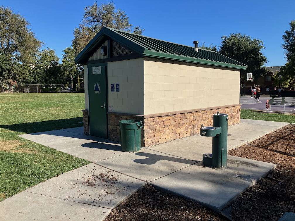
Roosevelt Park downtown has a new restroom, replacing the old one. There are two single-use, all-gender units, which is the current trend and probably much better than the older multi-user, gendered restrooms.
Roosevelt Park new restroom
The restroom in Fremont Park, right across the street as I type, has been closed for years, and despite the sign, is never open during events. Porta-potties are used for events at this park.
Fremont Park restroom closed
I have not traveled to all the city parks to see which restrooms are open, which are open but with limited hours, and which are closed, but my impression is that about half the park restrooms in the city are closed. The city has a GIS map of park restrooms, but no indication of whether the restrooms are actually open or not: https://data.cityofsacramento.org/datasets/b9e7fa6d1d104833b3f04268d7f682dc_0/explore. Park restrooms are valuable for walkers, but very few are located on transit routes.
There are no public restrooms at transit hubs. No restrooms where people are waiting for the next train or next bus. The next bus, at transfer points for low frequency routes, can be quite a long wait, up to 45 minutes assuming the buses are on schedule. Even at Sacramento Valley Station, where a number of modes converge, you can only use the restroom by showing an Amtrak train ticket. Using light rail or bus, or just walking or bicycling, you are out of luck. (Note: Many people assume that Amtrak or Capitol Corridor owns the train station, but it is owned and managed by the city.)
Some light rail stations and a few bus stops have restrooms for the transit operators, but not for the public.
The city should:
re-open or replace all park restrooms, within two years
install public restrooms at every city park which does not currently have them; this would include Muir Children’s Park, Grant Park, Winn Park, and several others
install a public restroom at the bus layover point on L St & 14th St
install a public restroom at the 16th St light rail station (where the Gold Line and Blue Line diverge, and the most used transfer point)
install a public restroom at 7th St & Capitol Ave light rail station (where the Blue Line, Gold Line and Green Line diverge; the 8th St & Capitol Ave stop is a block away)
identify locations throughout the city where walkers and transit users congregate, and install public restrooms there
You might wonder why I’m asking the city to install transit restrooms rather than SacRT. The reason is that I see it as the responsibility of the city to provide restrooms everywhere they are needed, not of the transit agency, though of course the projects could be joint projects.
Note: As is not unusual, I had forgotten that I’d written about N St before: N Street bike route to cycle track, 2015. Seven years have passed, the city has taken no action.
The construction for the Capitol annex project has narrowed N St to two lanes eastbound, from 10th St to 14th St, and parking has been removed from the south side to shift the lanes over. Now is the time for the City of Sacramento to implement its long-delayed (if not deep-sixed) plans for re-allocating space on N St. There have been ongoing utility projects over the last few years that have narrowed N St to two or even just one lane. At no time did that create significant congestion, during the pandemic or before the pandemic. I live two blocks from N St, and both travel along it and cross it frequently. I’ve never seen more than momentary congestion, in 11 years. What that means is that N St, in its three-lane configuration, has grossly excess capacity for motor vehicles.
While the street has been narrowed is the time to redesign the street so that it has no more than two general purpose lanes, and has a curb-protected or parking-protected bikeway. Probably on the left. This is in fact the perfect setting for a separated bikeway, five blocks from 10th St to 15th St with no intersecting streets from the north side, which is Capitol Park.
It is true that the sidewalk on the north side of N St is a designated bikeway, so bicyclists may use the sidewalk to avoid riding in the street. But bicyclists on the sidewalk are often in conflict with people walking on the sidewalk. The sidewalk has pretty continuous use by walkers, particularly during the lunch time – walk time for state workers, but a lot of people also include a circuit of the Capitol Park on their runs and walks. This conflict is easy to solve: create a safe, welcoming, protected (separated) bikeway on the street. And do it now!
On N St eastbound, the leftmost lane is a designated left turn lane at 10th St, which is what makes possible the two-lane configuration beyond 10th St. As a temporary measure, this works well, and forcing turns off three lane streets is a good solution for so many overbuilt arterials roads in Sacramento, but here it is only temporary, and would be obviated by the conversion of all of N St from 3rd St to 15th St. N St becomes a two-lane street at 15th St, and then becomes a two-way street at 21st St. N St from 15th St to 21 St would probably be a good candidate for a separated bikeway as well, but with paint bike lanes existing, would be a lower priority.
Below is a StreetMix sketch of what N St might look like. Note that the width of the street and the elements are estimated, not measured. I don’t believe parking is needed on both sides, but the diagram shows it for people who think it is necessary. Left side is north, Capitol Park in this case, and right side is south, mostly state buildings.
N St Sacramento between 3rd St and 15th St
As a reminder, I feel strongly, and it is backed up by evidence:
Three-lane streets are significantly less safe than two-lane streets, primarily for the muli-lane threat (one vehicle stops for walkers and the others do not). They are also a clear sign of poor land use planning, which puts residents and the things they need to reach (jobs, stores, recreation and entertainment, medical, etc.) far away. Narrowing all such roadways in the city from three to two, or less, would increase safety, increase livability, and encourage people to make different choices about where they live and visit. Maps of collisions (vehicle vs. vehicle, vehicle vs. walker, vehicle vs. bicyclist) align almost perfectly with overbuilt arterials.
One-way streets are significantly less safe than two-way streets, for the same multi-lane threat, and because there isn’t any friction to slow drivers. However, I think that the only valid argument for one-way streets is to accommodate separated bikeways, bus lanes, or rail transit. That may be true of N St.
And, sorry, can’t resist, get rid of the worthless palm trees while they are at it. We need shade trees, not poles.
TIRCP (Transit and Intercity Rail Capital Program) grants for 2022 have been announced, with two in the Sacramento region. One is a joint application from Capitol Corridor JPA, City of Sacramento, SACOG, SacRT, and Downtown Railyard Ventures, for work related to Sacramento Valley Station realignment of light rail and buses. The second is for SacRT to purchase eight more modern low floor rail cars.
4. Capitol Corridor Joint Powers Authority (CCJPA), with the City of Sacramento, Sacramento Area Council of Governments (SACOG), Sacramento Regional Transit District (SacRT), and Downtown Railyards Venture, LLC (DRV)
Project: Sacramento Valley Station (SVS) Transit Center: Priority Projects Award: $49,865,000 Total Budget: $95,050,000 Estimated TIRCP GHG Reductions: 156,000 MTCO2 e
This project delivers a set of interrelated projects to introduce better connectivity between modes at the Sacramento Valley Station, as well as redesigned commuter and intercity bus service to the SVS and Downtown Sacramento, that will increase ridership on both trains and buses. Project elements include design of a new bus mobility center to facilitate convenient transfers between modes, realignment of existing light rail tracks and construction of a new platform, construction of a new cycle track on H Street to improve access to the station, and construction of a new pick-up and drop-off loop.
The light rail tracks will be realigned into a loop with a new north-south oriented platform just south of the Steve Cohn Passageway entrance (about 450 feet closer to the rail tracks than currently, and only 100 feet from the future Bus Mobility Center), as well as a new double track alignment from the new platform to the intersection of F Street and 6 th Street. The construction of the new pick up and drop off loop at the station will allow more efficient transfers. The project includes installation of a new storm drain trunk line which will enable new transit-oriented development on key parcels next to SVS.
A new regional bus layover facility will be built in a 2-block portion of X Street between 6th and 8 th Street. The proposed facility will allow buses to layover in Sacramento between runs, improving bus efficiency and reducing vehicle miles traveled, as well as fossil fuel consumption. Initial users of the facility are expected to include El Dorado Transit, Galt-Sacramento SCT Link, Placer Transit, Roseville Transit, San Joaquin RTD, and Yuba-Sutter Transit.
The project will also support the consolidation of downtown regional bus routes, building on the study SACOG completed with 2020 TIRCP funding. Construction of shared stops between SVS and the future Midtown Amtrak San Joaquin and Altamont Corridor Express station will be completed, including the reuse of seventeen bus shelters from the Temporary Transbay Terminal in San Francisco. This component will also complete an unfinished portion of 5 th Street between Railyards Boulevard and North B Street as the most efficient connector for all north area buses to access the freeway to SVS and serve the new state office complex on Richards Blvd. That will provide the connectivity to implement 10 additional bus stops (5 northbound and 5 southbound) north of H Street. Commuter buses operated by Amador Transit, Butte Regional Transit, El Dorado Transit, Soltrans, Galt-Sacramento SCT Link, Placer Transit, Roseville Transit, San Joaquin RTD, Yolobus and Yuba-Sutter Transit will be routed along new shared northbound and southbound routes. This work will complement SacRT’s TIRCP-funded network integration to better integrate its service with intercity rail at both SVS and the future Midtown station.
The project will also purchase and install contactless EMV readers coordinated with the California Integrated Travel Project on rail and bus vehicles to allow fares to be collected through contactless bank cards and mobile wallets.
Ridership at Sacramento Valley Station is also expected to be positively impacted by the city’s housing policies, confirmed with a Pro-Housing designation by HCD, the first city to receive such a designation in the state. A significant amount of housing is expected to be added in the Railyards District, adjacent to the station area.
These plans will be developed in cooperation with many transit partners and agencies throughout the Sacramento region, and with additional technical assistance provided by the California Department of Transportation, in order to ensure integration of regional and interregional capital improvements and service.
Project is expected to be completed by 2025.
Key Project Ratings: Medium-High Cost per GHG Ton Reduced: Medium-High Increased Ridership: High Service Integration: Medium-High Improves Safety: Medium Project Readiness: Medium Funding Leverage:High Multi-Agency Coordination/Integration: Priority Population Benefits: Medium-High Housing Co-Benefits: High
15. Sacramento Regional Transit District (SacRT)
Project: Fleet Modernization Project Award: $23,600,000 Total Budget: $47,200,000 Estimated TIRCP GHG Reductions: 44,000 MTCO2 e
Purchases 8 new low-floor light rail vehicles (LRVs) to further expand low-floor fleet operations on the light rail system. Over one-third of SacRT’s light rail fleet has reached the end of its useful life, and this investment leverages past TIRCP grants, as well strong local match, to help modernize the fleet.
Low-floor LRVs will produce operational efficiencies by speeding up train times and optimizing boarding convenience and safety along with increased capacity. They also will increase fleet reliability and reduce the number of shorter than planned trains need to be operated on the system. These are significant benefits to persons with disabilities, seniors, parents with strollers, and bicyclists, who will have more boarding options and increased boarding and alighting safety. These improvements are expected to support retaining and attracting new light rail riders, including residents of disadvantaged communities, who make up 30% of the population within SacRT’s service boundary.
The project also supports sustainable housing and land use development while providing meaningful benefits to priority populations by improving mobility and access to transit options. The project complements several TOD/joint development projects underway along the light rail corridors, including a surplus SacRT property near a station that was sold to an affordable housing developer who has entitlements and plans to begin construction on 128 units.
Ridership on SacRT is also expected to be positively impacted by further rollout of integrated contactless payment throughout the light rail and bus system, as well as by the city’s housing policies, confirmed with a Pro-Housing designation by HCD, the first city to receive such a designation in the state.
19 Project completion is expected by 2027.
Key Project Ratings: Medium-High Cost per GHG Ton Reduced: Medium Increased Ridership: Medium-High Service Integration: Medium-High Improves Safety: High Project Readiness: High Funding Leverage: Medium-High Multi-Agency Coordination/Integration: Priority Population Benefits: High Housing Co-Benefits: High
Applications made for Active Transportation Program cycle 6 from counties and cities within the SACOG Region. So far as I know, no other details about these projects are available yet. The application period for the state-level program just closed. pdf version
I walked by the section of Capitol Ave in Sacramento, east of 18th St, as I have done many times, but today it struck me how dead this street is, now. It was alive for a while:
Capitol Ave, Sacramento, pandemic street closure, August 2020
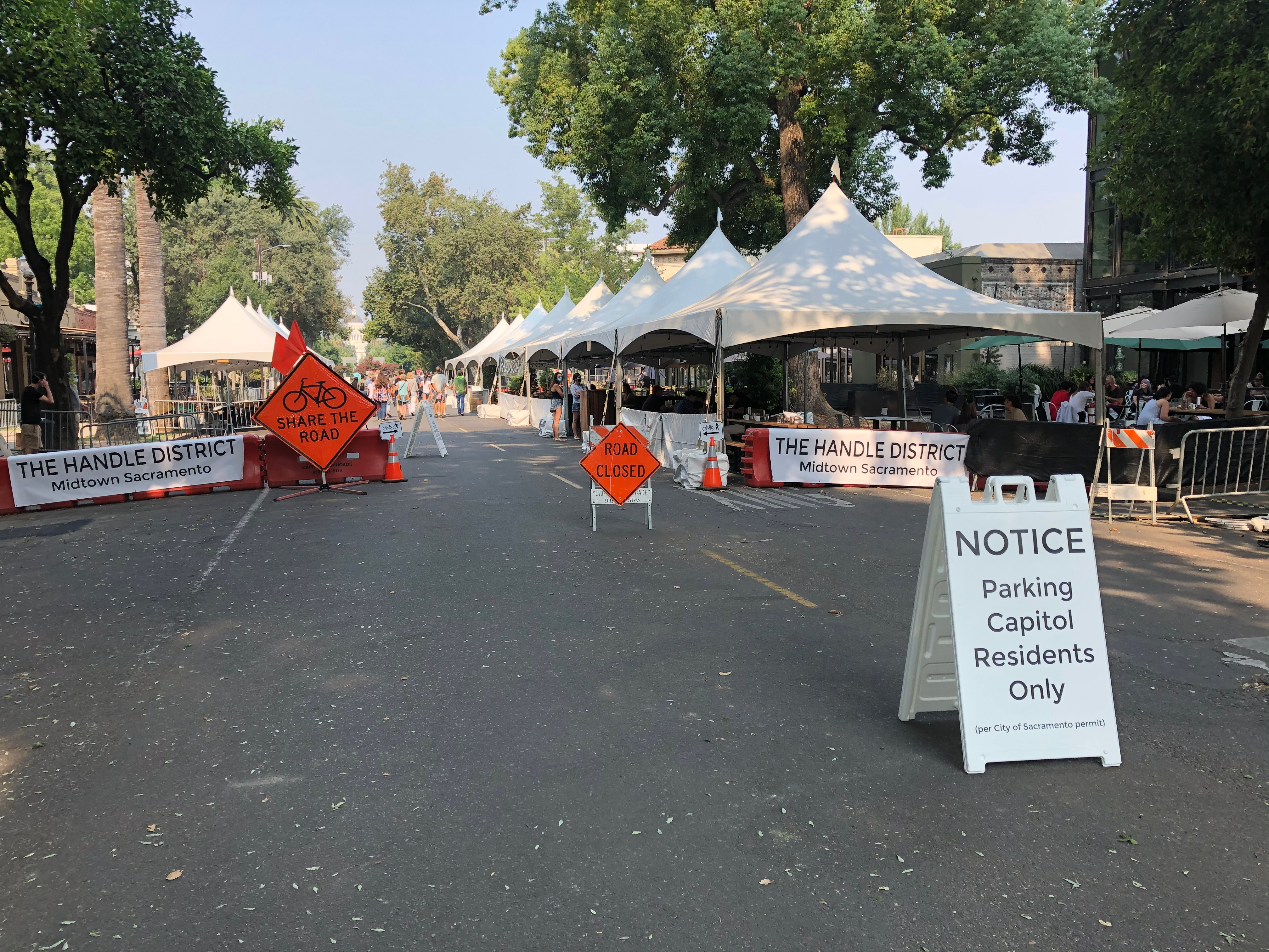
But now it is sick again. To extend the analogy, it has always suffered from car sickness (a street dominated by motor vehicles), but had a relatively brief recovery when the street was closed to cars and opened to people walking and bicycling, and now a relapse into car sickness:
Capitol Avenue, Sacramento, opened to cars but not people, June 2022
The street feels abandoned. There are no people walking or bicycling. There are a very few people at the restaurants. It is hot, hot, hot, with insufficient street trees and an overly wide pavement. Note that if the street were closed (to cars) again, the street could be significantly narrowed, just space for bicyclists. Parking, unnecessary. Bike lane, unnecessary. Travel lanes, just enough width for emergency vehicles. Leaving plenty of space for outdoor dining, and street trees, and even a little nature.
During the closure (to cars), the street felt alive, even when there were few people there, even in the morning before most of the restaurants opened. People were walking and bicycling, and hanging out.
I don’t know why the closure was ended, and all the street canopies and seating removed. I’ve heard a lot of different stories: it was the city, it was the Midtown Association, it was the business owners. So I can’t point any fingers. But what I can say is that what was once clearly alive is now barely hanging on. Will it die? Probably not, but it won’t ever be healthy again, until the cars are again removed.
Cars kill business, cars kill cities. Why do we allow our city to be dominated by cars?
At the SACOG Board meeting this morning, the board passed the staff-recommended agreement that authorizes Executive Director James Corless to negotiate an MOU (memorandum of understanding) with the transportation sales tax measure proponents and SacTA (Sacramento Transportation Authority) to include elements of the agreement in the MOU and in the ballot measure statement of support.
There was a lot of controversy over this issue, more than I have seen at any board meeting. Representatives of the other five counties (Yolo, Yuba, Sutter, Placer, El Dorado) and the cities within expressed great concerns about the agreement. Some voted no, some voted reluctantly yes, but there was no enthusiasm. The only really enthusiastic voice at all was from David Sander, representative of Rancho Cordova, who is also conveniently the board chair of the Capital Southeast Connector JPA. Even James Corless who supports the compromise expressed considerable discomfort that the agreement was even necessary to keep SACOG in the discussion.
The agreement implies that each new project (not in the current MTP/SCS) will have to completely mitigate all greenhouse gas (GHG) emissions from the reduction. Left unanswered is how that can be accomplished. How can a project like the sprawl and VMT inducing Capital Southeast Connector be mitigated? Will the project fund all mitigation, or will the project proponents come back to SACOG or SacTA begging for funds for mitigation? Are all the other projects expected to pick up the slack in order to meet the required reduction in GHG? Will projects in the other five counties be expected to pick up the slack? Nothing in the agreement says the proponents of these capacity expansion projects will help to meet the regional target of 19% GHG reduction.
Don Saylor of Yolo County asked some very pointed and relevant questions of Corless and SACOG Counsel Kirk Trost. Trost confirmed that it is unlikely that any signatories to the MOU could be held legally accountable, that the MOU would be worthless if it continued the same vague language in the agreement, and that the whole thing was dependent on the good will of all the players. All players includes Sacramento County and each city in the county, and by implication, the Sacramento Metropolitan Air Quality Management District. It is not at all clear whether they will all sign on, or that they will fulfill their agreement. The commitment to the 1970s model of transportation (the dark side), which the measure proposes to continue for 40 years, is very strong among many of the entities in the county, and it would not be surprising if some decided to back out on or just ignore the commitment to mitigating ALL GHG impacts of each project.
The original motion to adopt the agreement and delegate to Corless was modified to include a review (not approval) by the board chair and the chairs of the SACOG committees. A second motion to include formal representation on the review by the other five counties failed, but Corless promised to reach out to them.
Most board members just held their nose and voted yes.
My comments were directed at the mis-information that was being provided by signature gatherers, talking about fixing streets, support for bicycling, and “it’s all for transit”. There was never mention of freeways, interchanges, or capacity expansion, which is largely what the measure is really about. The measure proponents clearly intended to fool the public into signing by not telling the truth about the TEP (Transportation Expenditure Plan). Of course many ballot measures have the same dishonesty, but it is significant in this case because these are the people that Mayor Steinberg and Corless were negotiating with ‘in good faith’. There is no good faith with the proponents.
I think the transportation advocacy community can see a small victory here in that many people are now coming to understand how bad the proposed measure is and specifically how it will harm the region. And they saw today how the proponents intended to bully SACOG, in the measure language, and in this agreement. We lost on this particular vote, but board members can’t really deny anymore that the transportation future of the county and the region has been hijacked.
For more on the measure, see Measure 2022 posts. The use of this category is not meant to confuse. A lot of people are referring to this as Measure A, but the measure letters are assigned by county elections after they have qualified, so this is in no sense Measure A at this time.