Streets for People interactive map

Additional posts on Streets for People Active Transportation Plan are at category: Active Transportation Plan.

The interactive map developed for the Streets for People Active Transportation Plan is available for public input through August 11. The ‘add a route’ and ‘add a point’ options have a free-form entry box, so you can enter anything you would like, but using terms that the city uses, in the visual glossaries (below) or the traffic calming features (below) are more likely to be understood and accepted.

You can comment on the city’s recommendations: “Clicking on a draft network recommendation will launch a pop-up that will provide more information about the recommendation. You can leave a comment, like, or dislike on any recommendation.”

Or you can add your own: “Are there roads or intersections that don’t have a recommendation, but you think should? Use the “Add a route” and “Add a point” buttons below to mark these locations on the map.”

The interactive map offers visual glossaries for pedestrian infrastructure and classes of bikeways. Since you can’t have these glossaries open at the same time as the map, they are offered as blog posts and pdf documents by Getting Around Sacramento.

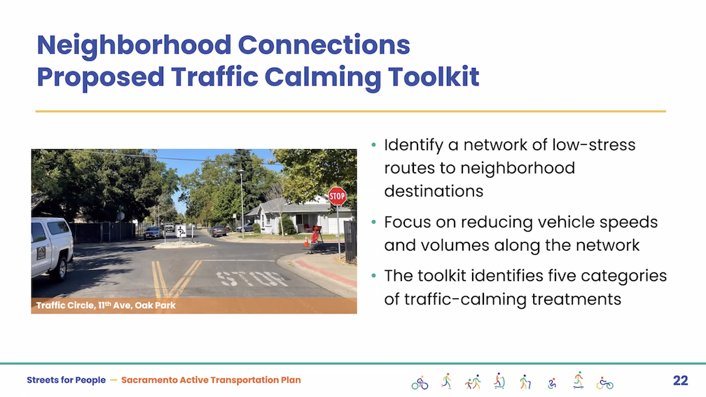
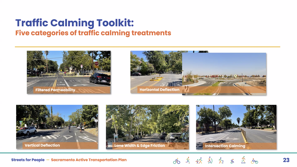
Traffic Calming Features

The City of Sacramento has added the Neighborhood Connections Story Board to the Streets for People Active Transportation Plan webpage. The traffic calming tab has 13 features, with photos, brief descriptions, and relative costs. These traffic calming features are meant for local and minor collector streets, not for major collector and arterials streets. See Streets for People traffic calming for the 13 features.

The crowd-sourced entries on the map are concentrated in the central city and north Land Park. We hope that people who walk and bicycle in other parts of the city, particularly the disinvested areas of South Sacramento and North Sacramento, will make suggestions on the map.

Neither the glossaries nor traffic calming features offer fully signalized intersections as a recommendation. Traffic signals regulate motor vehicle flow to some degree, but do not significantly slow traffic nor make streets safer for walkers and bicyclists. Safety is best achieved by slowing the motor vehicles through street redesign.

The ‘bicycle routes’ / sharrows option in the Visual Glossary of Classes of Bikeways has been misused by Sacramento and many other cities/counties/Caltrans by placing them on high volume and high speed roadways, in lieu of creating safer bicycle facilities. Their use should be strictly limited, and most existing locations should be converted to higher quality bicycle facilities.

CalBike series on Caltrans complete streets failure

CalBike has published the first two of a series of reports on the failure of Caltrans to follow their own complete streets policy when designing and building streets which are also state highways. It is telling that the first of the series is on the failure of Caltrans District 3, which includes Sacramento county, to actually provide complete streets – Incomplete Streets Part 1: How Caltrans Shortchanges Pedestrians. District 3 is perhaps the worst of the Caltrans districts, which operate as independent (or rogue) agencies and regularly subvert Caltrans policy and direction from headquarters. Though they have a lot of competition for the title of worst.

“District 3 is perhaps best known as the district pushing through the Yolo Causeway highway expansion project. The project, which has been approved despite internal and external opposition, led to the firing of Caltrans Deputy Director Jeanie Ward-Waller after she blew the whistle on improper use of funds for freeway widening and insufficient environmental review.”

I encourage you to read these first two, and to follow CalBike investigative reporting. Caltrans must be held to account, as otherwise they will continue to design projects that kill and injure walkers and bicyclists, will continue to resist fixing the design mistakes they have made in the past, and will continue to commit fraud on the people of California by lying about what they are doing with your tax money.

Central City Mobility Project update: 5th Street conversion

This is Central City Mobility Project update #35.

I noticed over a week ago that all striping has been removed from 5th Street, including crosswalks, so had presumed that the conversion from one-way to two-way was immanent. Nope. Nothing has happened since then. I guess the city thinks it is OK to remove striping from a street and then do nothing. In a sense, it might be OK, because drivers, without striping to guide them, will be uncertain, and slow down. Maybe.

photo of erased crosswalk on 5th St
erased crosswalk on 5th St

Broadway Complete Streets update

I mistakenly included an item on 5th Street in this post, but I’ve now removed it to a separate post.

Note: Dan Allison, the primary author of this blog, spends most of July and August, and some of September, backpacking in the mountains, in the wilderness, and away from Internet access. So posts will be very intermitent, though some will show up when I’m in town, as I am for a few days.

Additional posts on Broadway Complete Streets are available at category ‘Broadway Complete Streets‘.

Green Paint

Green paint seems to be complete along the corridor, except of course for 19th Street to 22nd Street where no changes to the roadway have occurred.

18th Street Bus Stop

The project proposed to move the bus stop for Route 51 from the far side of 18th Street to the near side, in front of New Helvetia Brewing, even though far-side bus stops are preferred and safer. But the design of the sidewalk and sidewalk buffer makes it a poor bus stop, with access to the front (and handicapped ramp) and rear doors difficult. A green striped area, meaning a shared bus stop and bike lane, has been installed, but is being used as a parking area by drivers. The area is not signed for no parking, nor is the curb painted red. The bus stop has not been moved. I don’t know if it will be moved.

bus stop Broadway eastbound at 18th St, with parked cars

Bicycle Signal at 16th Street

The non-functional bicycle signal on Broadway eastbound at Land Park Drive now works (and has for over a week, but I didn’t get to posting until today). It took the involvement of city planning staff to get it fixed, as the traffic signal people did not care that it didn’t work, and did not fix it after multiple 311 requests.

However, it is not safe. There are large and prominent no turn blank-out signs for motor vehicle drivers turning south onto Land Park Drive, illuminated when the green bicycle light is on, and blank when it is not. The signs are hard to miss. It isn’t working.

I observed 54 drivers turning right at this intersection, not during a busy time of day. 52 of them violated the law and turned right against the no turn signs. Two did not. Both of those drivers noticed that I was taking photos, and did not turn, while looking at me to see if I was going to capture their license plate on a photo. I’m pretty sure those two would have turned if I’d not been there.

This would be a great location for a red light camera. Oh, but wait, the city has decided it is not interested in red light cameras. Drivers are free to run red lights at will, since there is no automated enforcement, and there is no direct enforcement.

The city’s design objective for streets should be that they are self-enforcing, physically making sure that drivers behave safely for all road users. This is an example where the city decided to rely on drivers following the law. Clearly a failure, on the part of the city, and the part of the drivers.

just one of many drivers violating the law by turning against the no turn signs

Construction Signs

At the southwest corner of Broadway and Land Park Drive, there are two sidewalk closed signs. I am not sure whether these are related to the construction on the southeast corner, or are leftover remnants of the Broadway project. In the photo below, the sign on the left is oriented to walkers heading north on Land Park Drive, but it should be oriented to walkers heading east on Broadway. The sign on the right doesn’t make any sense at all for this location, no matter how it might be oriented. Whether this is a mistake by city contractors, or the construction company, makes no difference. It is the city’s responsibility to make sure that signing is appropriate and correct. It has failed miserably at that responsibility.

incorrect construction signs southwest corner of Broadway and Land Park Dr

Photos on Flickr. An album of photos of the Broadway Complete Streets project, during and after construction. No promise is made that the album will be kept up to date.

Strong SacTown Street Design: Local Street Typology

Local Street Typology is the sixth post by Strong SacTown to improve and promote the City of Sacramento update to its Street Design Standards. Other posts at tag: street design standards.

“Local Streets are an extension of the adjacent land uses and provide space for people to socialize, play, and even loiter, and will be designed and managed as places primarily for people. People are likely to spend most of their time in or near Local Streets, since these are where to find most destinations. As such, it should feel natural and comfortable to dwell in or stroll through a Local Street. Parents should feel comfortable letting their kids play unsupervised, and noise levels are low enough to hold a conversation.”

Strong SacTown Street Design: Modal Filters

Modal Filters is the fifth post by Strong SacTown to improve and promote the City of Sacramento update to its Street Design Standards. Other posts at tag: street design standards.

“Also known as traffic diverters, or permeable filtersmodal filters hold the key to bringing back the pre-1920 sense that streets are for everybody and can be a shared space where all traffic can safely and slowly mix. They do this by reducing the number of cars on a given street or in a neighborhood via bollards or other physical barriers.”

diagram showing the improved safety of streets in the northeast quadrant of the central city

Streets for People virtual slides

Additional posts on Streets for People Active Transportation Plan are at category: Active Transportation Plan.

The City of Sacramento held the Streets for People Citywide Virtual Workshop #1 yesterday. Though the city may eventually post the slideshow, it is not on the program page Streets for People Active Transportation Plan yet, so I’m posting them here. These are low-ish resolution screen captures, so you won’t be able to see detail in them, but I hope they are still useful to you. I did not capture every single slide, but I hope the ones of interest are here. Of course the slides do not capture the presenter comments that went with each slide, which are important.

The next workshop, Streets for People Citywide Virtual Workshop #2, will be tomorrow, July 11. Please see the program web page for registration link. I assume the presentation will be the same.

The first workshop was poorly attended. I don’t know how many people, but the presenters mentioned several times how few people were on the webinar. My question/comment is that the Traffic Calming tab of the Neighborhood Connections storymap has the best examples of traffic calming measures, with many of the photos local, whereas the visual glossary pedestrian and visual gallery bikeways examples provided as part of the interactive map are of poorer quality, not local, and in a few cases should not be recommended at all. These two sources should use the same examples, where they overlap.

The second workshop will be followed by a series of focus groups for particular neighborhoods or areas of the city, and walk audits in those same areas. I hope that people will participate in one or more of them.

Broadway Complete Streets update

Additional posts on Broadway Complete Streets are available at category ‘Broadway Complete Streets‘.

Green Paint

Green paint has been added to parts of the Broadway Complete Streets project, mostly to the west of Riverside Drive/11th Street, and some to the west of Land Park Drive/16th Street. I did not see any green paint east of Land Park Drive/16th Street. Several areas marked for green paint have not yet been painted, so this aspect of the project is certainly not complete. Where it has been completed, it is pretty nice, well done.

Broadway at 3rd St, bike lane with skipped green marking

Several bus stops have been or will be marked with extra wide green paint, indicating a shared bus and bike area. For most of Broadway, the bus is SacRT Route 51, with a frequency of 15 minutes, but from 9th Street to Riverside Drive/11th St, SacRT Route 11 is also present. Shown below is the bus stop just before 10th Street, which is the only transfer point between routes 11 and 51, and was destined to be removed by the city before SacRT complained. The bus stop should have been moved to just beyond 10th Street, and served with a bus boarding extension, but this is better than nothing.

Broadway at 10th St, shared bus stop and bike lane green marking

It is worth remembering that green paint has no legal meaning. It is informational, meant to mark potential conflict areas between motor vehicles and bicyclists. As such, it is worthwhile, but bicyclists should always remember to be situationally aware and to not think of green paint (or any paint) as protective.

16th Street Conversion

The block of 16th Street between Broadway and X Street has been converted from one-way to two-way. This may have happened a while ago, and I missed it, but below is a photo from today. The conversion is an attempt to encourage drivers to use X Street eastbound to access Broadway to the east of 16th Street, or Land Park Drive.

conversion one-way to two-way, 16th St between Broadway and X St

Confusion approaching 16th Street

I spent time today observing driver behavior, turning right from Broadway westbound onto 16th Street. Some drivers pulled to the curb, over the bike lane. This is actually the correct legal behavior under California law, to turn from as close to the curb as reasonable, however, many drivers are not aware of this law. Other drivers stuck to the general purpose lane and turned from it. Of course turning from the lane risks right-hooking bicyclists who have the right-of-way in the bike lane (straight traffic always has the right-of-way over turning traffic). There are similar situations all over the city, where drivers don’t know the legal behavior, and bicyclists are at risk. But at this location, with frequent right turns from Broadway to 16th Street (which the city wants to encourage to get motor vehicles off Broadway if they are not continuing to a destination on Broadway), but city has failed to make it clear what the proper behavior is, and has failed to make it safer for bicyclists. The best solution would be to install a bicycle signal here, and provide bicyclists their own safe passage through the intersection. The next best would probably be to modify the markings so that the double white line is broken, indicating that this is a mixing zone and not an exclusive bike lane. As it is, it will lead to conflict and danger for bicyclists.

Broadway westbound at 16th St, confusing bike lane and motor vehicle mixing

Photos

Photos on Flickr. An album of photos of the Broadway Complete Streets project, during and after construction. No promise is made that the album will be kept up to date.

dangerous bike signal on Broadway

Additional posts on Broadway Complete Streets are available at category ‘Broadway Complete Streets‘.

On Broadway eastbound at Land Park Drive, there is a bicycle signal face, shown below. The signal is permanently red, it never changes to green. The presence or absence of bicyclists makes no difference; it does not change from red. This is confusing both motor vehicle drivers and bicyclists. Bicyclists wait for it to change, and it never does. Drivers wonder why bicyclists are proceeded along Broadway with the green ‘car’ light when the signal clearly says that they should not be proceeding. I have seen drivers yelling at bicyclists for going when it is not their turn, and this has been reported to me by a number of people.

This issue has been reported to the city, twice by myself, and multiple times by other people. It has been this way for at least two weeks, perhaps longer. The city has decided to ignore these reports and to not fix the issue. The city is endangering bicyclists, and is in fact legally liable for knowing that a safety hazard exists and doing nothing to respond. This is criminal behavior on the part of the city. Sorry to be so blunt, but when city employees, or contractors acting on behalf of the city, ignore a known and easily solvable safety problem, that is criminal behavior. Period.

This would be so easy for the city to temporarily solve, by covering the bicycle signal face so that it is not visible. The pedestrian crossing sign over Broadway at the east side of the intersection is covered, due to the construction on the corner closing the crosswalk. Beyond a temporary fix, the city needs to determine why the bicycle signal face is not working, and make it work.

complete streets and intelligent speed assist

This week at the legislature, the Assembly Transportation Committee is hearing SB 960 (Wiener) Transportation: planning: complete streets facilities: transit priority projects, Monday, July 1, 2:00 PM in Room 1100 at 1021 O Street in Sacramento (StreetsblogCA: Complete Streets Bill Hearing Next Week). This bill would force Caltrans to follow its own policy on Complete Streets, which is seldom does, and could have a beneficial impact on all street redesign in California as many transportation agencies look to Caltran for guideance.

The Assembly Privacy and Consumer Protection Committee is hearing SB 961 Vehicles: safety equipment (Wiener), Tuesday, July 2, 1:30 PM, in Room 126, State Capitol. The bill would implement Intelligent Speed Assistance for all vehicles except emergency vehicles. Though considerably weakened from the original version, with passive rather than active control, it is still a valuable step forward, and would encourage NHTSA to speed up their policy process, which they have been slow walking (to preserve fast driving).

If you live in Sacramento and can attend, please do. All you can do at legislative hearings is ‘support’ or ‘oppose’, but since most speakers are paid lobbyists, hearing from actual citizens can be powerful.

CalBike What are complete streets? graphic