A group of partners led by Valley Vision is undertaking a project to identify location for new air quality monitors in low-income, high-pollution areas of Sacramento, specifically Old North Sacramento and Oak Park. For more on the project, which will install 20 Clarity Node-S monitors for particulate matter 2.5 and nitrogen dioxide, see the Valley Vision webpage at https://www.valleyvision.org/projects/community-air-protection/.
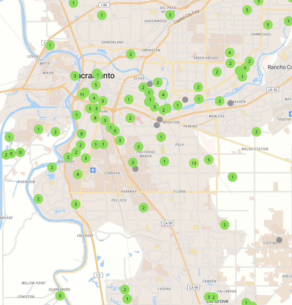
The issue is that these two communities are subject to significant negative air quality impacts from a variety of sources but primarily freeways which slice through both communities, and high-traffic arterials. But no one really knows what the problem is, because there are no air quality monitors in those neighborhoods. Below, a map of existing Clarity monitors. The concentration in South Sacramento is due to a similar earlier project, funded by AB 617, but there are none in Old North Sacramento, and one at the edge of Oak Park.

PurpleAir, a citizen-led network of air quality monitors, has a better distribution, but still only one in Old North Sacramento and a few in Oak Park. These are particulate matter monitors, and gained great popularity with the wildfire smoke incidents of the last few years.
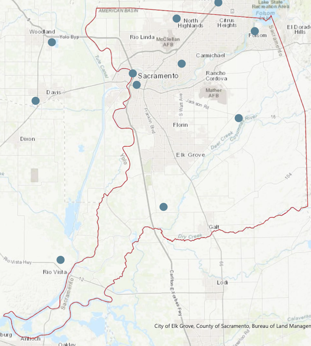
What about the official air quality monitors, the ones used to set air quality alerts for the county? Here they are (little red dots). You might think, surely some must be missing. Nope. These stations mesure air quality for the entire county. Update: I replaced the map graphic with one showing all Sacramento County locations, created a pdf map, and added a table of locations.

Sacramento County is a nonattainment area for ozone 8-hr (2015 standard), PM2.5 24-hr (2006 standard), and PM10 (1987 standard).
The project, of course, is not just about monitoring air quality, but about identifying solutions to improve air quality. Community Project Advisory Committees will be formed in both neighborhoods to guide deployment, data collection, and actions and ongoing collaboration for solutions.
I participated in the first listening sessions, for Oak Park, on January 13. Participants had a lot of suggestions for locations, particularly ones where there are high volumes of traffic, as well as places such as schools where the pollution is most harmful. There was also a lot of talk about solutions, with reducing vehicle miles traveled (VMT) by increasing walkability and providing better transit service being the most commonly mentioned.
There are three more sessions to come, January 20, 26, and 28. Please see the project webpage for details and to register: https://www.valleyvision.org/projects/community-air-protection/ (scroll down to just below the map).
If you live in these two neighborhoods, or work or shop or recreate there, I strongly encourage you to participate in some way and make your voice heard. Even for others, it would be good to track and support the project. I strongly believe that our lack of monitoring capacity allows us to think that air quality in the county is better than it really is, and allows the public to overlook that it is mostly low-income, high-minority neighborhoods that bear the brunt of air pollution from our cars-first development pattern and long distance commuter freeways.
Added two graphics showing the community areas in more detail.


One map that shows both the ‘official’ monitors and a selection of the PurpleAir sensors is Fire & Smoke Map, https://fire.airnow.gov/.
LikeLike
The California Air Resources Board is working on AQview, a web portal for air quality data which will include stations in the AB 617 program and other sources, all on one map. When this is implemented, it should remove the need for the separate maps, as were used in this post. https://aqview.arb.ca.gov/
LikeLike