Skip to content
  • Home
  • About
  • Reading List
  • Calendar
  • Maps
  • Quote
  • Bike Share
  • Links
Search
Close

Getting Around Sacramento

by foot, bicycle, and public transit (car-free!)

Tag: White Rock Rd

Scott Road Bike and Walk May 5

2013/04/26 Dan AllisonLeave a comment

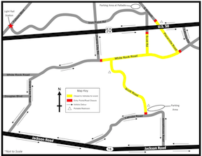
ScottRoad-mapOn Sunday, May 5, Sacramento County and the City of Folsom are closing a section of Scott and White Rock roads in the southeast part of Sacramento, in celebration of May Is Bike Month. The location is accessible from the Iron Point light rail station. See the 2013+Scott+Road+Event+Flyer for details.

  • Instagram

agenda bike-share bike-share bike lane City of Sacramento construction-zone crosswalk crosswalks Freeport Blvd funding JUMP light rail parking pedestrian SacATC SACOG Sacramento SacRT separated bikeway sidewalk sidewalks Strong Towns traffic calming Transit transportation transportation sales tax trees Vision Zero Vision Zero Action Plan walking

SacCity: VZ intersection 15: Grand Ave & Marysville Blvd

Note: General information on the Top 20 intersections, with criteria, list, and map, is available in post 1. Other posts on Top 20 intersections…

2026/11/10

SacCity: VZ intersection 14: Franklin Blvd & Fruitridge Rd

Note: General information on the Top 20 intersections, with criteria, list, and map, is available in post 1. Other posts on Top 20 intersections…

2026/11/10

SacCity: VZ intersection 12: 16th St and J St

Note: General information on the Top 20 intersections, with criteria, list, and map, is available in post 1. Other posts on Top 20 intersections…

2026/11/102026/11/10

Something went wrong. Please refresh the page and/or try again.

Log in

Blog at WordPress.com.
Back to top
  • Subscribe Subscribed
    Getting Around Sacramento
    Join 86 other subscribers

    Have a WordPress.com account? Log in now.

  • Getting Around Sacramento
    View site in Reader
    Manage subscriptionsSign upLog in
    Report this content
    Collapse this bar
Loading Comments...