I have been getting questions from several people about how the turn wedges being installed as part of the Central City Mobility Project are supposed to work. In particular, this applies to all of the concrete wedges, which are at the intersection of the separated bikeways, but applies most of the other wedges as well.
First, the diagram from the Central City Mobility Project design document. This is turn wedge style 3, with concrete turn wedge. The other four styles have speed bumps and vertical delineators.
diagram, Central City Mobility Project, turn wedge style 3
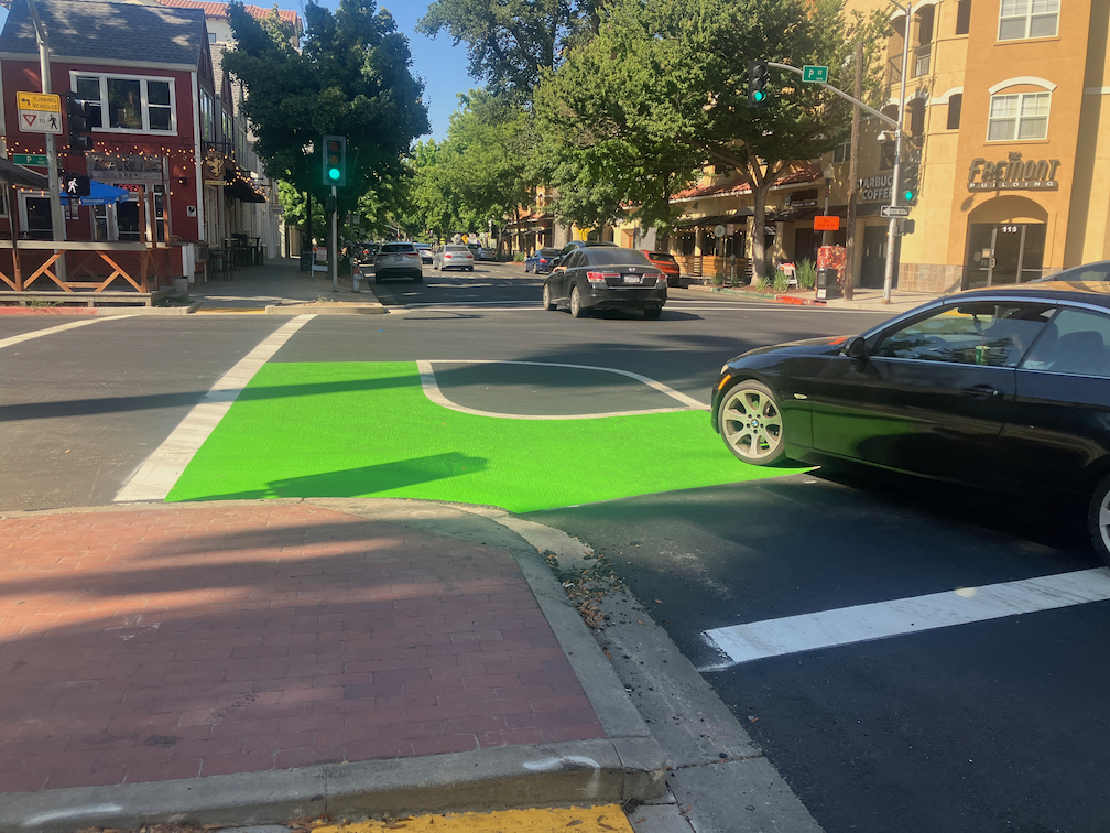
Second, a photo of an actual concrete wedge in place.
photo, concrete turn wedge at 21st St & P St
The issue that has been pointed out by more than one reader is that a motor vehicle driver can also cut between the turn wedge and the curb, to the left of the turn wedge, rather than to the right, as was intended by the design. Wow! That is a flaw. How did this happen?
Well, the city has designed partially rather than fully protected intersections. Not only are these protections only on one corner, but they are not designed according to NACTO (National Organization of City Transportation Offices) guidance. Here is the NACTO diagram, from the Protected Intersections page.
NACTO Protection Intersection diagram
What is different? Look at the approach from the left side of the diagram. There is a concrete island, labeled 3, which prevents motor vehicle drivers from cutting through between the turn wedge (‘corner island’ is the NACTO term) and the curb. It is likely that the area labeled 1 would also be a concrete island. This island not only protects bicyclists, but more importantly, protects walkers and shortens the crossing distance. I will include text from the NACTO page below, because the details are really important.
So, how to fix the Sacramento problem? Concrete islands need to be installed in the upstream direction, before the crosswalk. In the case of the photo above, this would be where the photographer is standing. Without such protection, this cannot be considered in any way a protected intersection or separated bikeway (protected bikeway). The radius of the turn wedge is also much greater than the NACTO recommendation, 30 feet rather than less than 18 feet (see second bullet below). So we are back to ‘turn wedges of death‘. I have to say, this is typical of the city, to take a good idea and sort of implement it.
Thank you to the reader who pointed out this design flaw, and caused me to look more closely, and think more closely.
A post today on Streetsblog LA (Santa Monica’s New 17th Street Curb-Protected Bike Lanes are Amazing) is about new bicycle facilities on 17th Street in Santa Monica. I think you will find some of the photos interesting. At first glance, it looks like some of the ones being installed as part of the Central City Mobility Project, but looking more closely, two differences really stand out. Most of the separated bikeways in Santa Monica are curb-protected. Bikeways that are solely parking protected only are protected when cars are parked. Otherwise, they are really just buffered bike lanes. And the turn wedges are hard curbs with additional markers, not paint-only, and definitely superior to the Sacramento’s suggested turn wedges which might have vertical delineators or other markers, but won’t have curbs.
curb turn wedges in Santa Monica (from Streetsblog LA)
To illustrate the problem these curb turn wedges solve, see the photo below of a motor vehicle making a high speed dangerous turn over a painted parking wedge at P Street and 15th Street.
16th St & P St, Sacramento, high speed turn across painted turn wedge
Other
P Street markings including green paint are nearly complete. In two blocks, the green paint is nearly the entire block, for unknown reasons. There is nothing unique about these blocks. While green paint is useful to mark conflict areas, excessive use will just lead to maintenance expense over time.
Q Street has preliminary markings, but the temporary lane tabs still indicate overly wide and dangerous general purpose lanes.
19th Street is nearly complete from H Street to Q Street, but there is no marking south of Q Street. South of Q Street, the old bike lanes show in some places, but otherwise have been erased in favor of overly wide and dangerous general purpose lanes. Several blocks of the new bikeway are in the gutter pan, making an unacceptable rough and dangerous surface.
21st Street is complete except for a few spots that were missed and have not been picked up. The confusing arrow at 21st Street and W Street has been corrected. There is still accommodation or signal for bicyclists at 21st Street and I Street.
I Street work has begun, with the last few ADA ramps complete and some repaving.
10th Street has the last few ADA ramps complete.
9th Street doesn’t have any work in evidence.
5th Street has not progresses past installation of signal bases.
Overall, no vertical delineators have been installed at any locations.
Delivery vehicles are parking in and blocking the separated bikeway on P Street approaching 16th Street. The city did not mark any of the parking spaces for delivery use. Cones and barricades have been placed in the buffer to reduce this hazardous driver behavior, and have been removed by someone, and replaced by citizens, and removed by someone, and …
I have been following the progress of the Central City Mobility Project which has now mostly completed separated bikeways on 21st Street, half of 19th Street (H to Q), most of P Street, and now going to Q Street. One of the features of the design is ‘turn wedges’ which I have written about before: where the bike lane ends – update, where the bike lane ends, Central City Mobility update. I have spent a lot of time observing driver and bicyclist behavior at the intersections which have these turn wedges installed. The wedges are marked only by white paint, though city diagrams show them having some sort of physical barrier installed in them.
Drivers are using the turn wedges, and the buffer areas of the separated bikeway, to make very high speed, very wide turns at these corners, cutting the corner where a bicyclist might be riding. The prior configuration of a regular intersection did not allow such wide and high speed turns. I have seen a number of close calls between motor vehicles and bicyclists, and walkers, for that matter, since these high speed turns cross the crosswalk as well as the bikeway. These turn wedge corners are also encouraging drivers to run red lights, even more so than the usual red light running. I saw three drivers run the red on a single signal cycle, and a driver on the cross street had to slam on their brakes to avoid a collision. I’ve seen a large number of near-misses for motor vehicles.
It is not clear whether these turn wedges are complete or not. Will the city actually install something here that prevents or at least discourages these high speed dangerous turns? I don’t know. What I do know is that in the meanwhile, these turn wedges are a clear and present danger to bicyclists.
I spent time this afternoon watching left turns from P Street westbound to 15th Street southbound. Drivers were using the buffer area and the bikeway to form two lines of left turning traffic, where there should be only one. The block of P Street was completely devoid of parked cars, so drivers were queuing into two lines way back near 16th Street. Since the intersection is in no way marked for a double left turn lane, there were motor vehicle conflicts on every signal cycle.
Sorry to be the doom-sayer, but I have to recommend that bicyclists simply not ride on these streets until the projects are truly complete, with as full a protection for bicyclist as can be achieved with these less than international best practice designs.
The city’s attitude seems to be that since the bikeways will eventually be safer, we just have to put up with the unsafe situation in the meanwhile. I completely disagree. This may be criminal behavior on the part of the city, to remove moderately safe bike lanes and replace them with unsafe bikeways. If bicyclists (or walkers or drivers) die before the project is complete, is this just a ‘whoopsie’? Professional engineers designed this project, signed off on this project, and should be inspecting the project as it goes along. Why do we then have these unsafe situations? Is is intentional? Is it indifference to bicyclists and walkers? Is it professional incompetence?
It is imperative that all construction projects accommodate walkers and bicyclists, who are even more vulnerable at these projects than normally. The attitude of ‘it will be safer later’ is completely unacceptable.
The construction company for this project is McGuire and Hester. Though many people might blame these problems on the construction company, I don’t. It is the city’s responsibility to design safe projects, during and after construction, and it is the city’s responsibility to inspect projects to see if they are complying with the design, and to fix things if not. But I strongly suspect that the construction company is doing exactly what the city told it to do.
Note: Info on 9th Street and 10th Street added below.
For other posts on the City of Sacramento Central City Mobility Projects, see category: Central City Mobility Project. I’m not sure how interested readers are in my minor updates, but I think it is fascinating to see how the city is repurposing street right-of-way, solving problems (or not), and what is being prioritized in the overall project. I’ve not seen any signs of construction on P and Q streets, other than the ADA ramp work that has been going on for several weeks.
Turn Wedge
The project page has a diagram that I had not exactly seen anywhere before, the corner wedge, below.
Central City Mobility Project diagram turn wedge
I saw a location marked for a turn wedge yesterday, at 21st St and O Street, southwest corner, below. This is a little bit like a corner of a protected intersection.
Sac_21st-St-O-St-SW_turn-wedge
5th Street Two-Way Conversion
I looked at the length of 5th Street, from Broadway to I Street. I still have no insight into what will be done under Hwy 50 where there is a one-way block that is closely tied to the freeway onramps. I have requested clarification from the city but they have not answered yet. I’ll update when I hear.
Signal bases have been installed for new signals from W Street to N Street, but not north of there. Active work was going on at N Street. At R Street, it looks like the existing pedestrian flashing light will be duplicated for the other direction. This is not a full signal, nor a user-activated signal, but always on.
Between Broadway and X Street, 5th Street is two-way, four lanes, with sharrows marked (and very faded) in the outside lane. Sharrows are no longer considered valid bikeway markings, so presumably there will be marked bike lanes here. There are three very-wide blocks for 5th Street, from N Street to L Street, and from J Street to I Street. From N to L, there are two through lanes and one or two left-turn lanes, plus parking and bike lanes. From J to I, there are two through lanes and two left-turn lanes, plus parking left and right and a bike lane on the right.
On the west side of the intersection of 5th Street and I Street, there is a crossing prohibition. I hope that the city removes this prohibition as part of the project. In most cases, freeways onramps and off-ramps being an exception, crossing prohibitions are an attempt by the transportation agency to prioritize motor vehicle volume and speed over all other considerations. They are morally wrong, and should be legally wrong.
Sac_5th-St-N-St_extra-wide
I Street Separated Bikeway (and lane reduction)
Some work has started on the I Street separated bikeway, which will run from 21st Street to 12th Street (see the importance of I Street for why it should continue west). Most corner ramps were already ADA compliant, but the few that were not have either been upgraded or are in progress. Fabric covers have been set up over drain inlets, and temporary no parking signs line the street, so I assume repaving will occur soon. I don’t see any indication of whether the separated bikeway will be on the right side or left side of the street. I Street does not have SacRT fixed route bus service, which engenders left side bikeways, though there is some commuter bus service on the street.
The project map indicates that I Street will be “lane reduction and separated bikeway”, not parking protected separated bikeway, so this will be a different configuration than 19th Street and 21st Street.
I will be interested to see if the city will address the lack of sidewalk on the south side of I Street between 16th and 15th, where the city installed a loading dock for Memorial Auditorium in place of the former sidewalk. I strongly believe that removal of sidewalks, as was done here, are criminal (Sac permanently closes sidewalk).
19th Street Repaving
It looks at though 19th Street is not going to be completely repaved in the way 21st Street was, rather, it is getting spot repaving. I don’t know whether there will be an overlay so that the new marking are on a fresh blank canvas.
9th & 10th Street Parking Protected Separated Bikeway
The 10th street parking protected separated bikeway will be extended from Broadway to Q Street. The block of Q Street to P Street has a buffered bike lane, outboard of parking in the south half, and without parking in the north half, and since that block has recently been changed, it will likely stay that way. There is a buffered bike lane from Q Street to L Street, and then a parking protected separated bikeway of variable quality from L Street to I Street. There is no bus service on 10th Street, so the right side configuration will probably be maintained throughout.
10th Street is relatively wide under Hwy 50, so no special treatment here will be needed.
On 10th Street there are ADA ramp upgrades at several locations, and several more haven’t started yet. The street has a lower rate of ADA compliance than many central city streets. There is no indication of roadwork yet.
The 9th Street parking protected separated bikeway is being extended south from L Street to Q Street. There is no indication of any sort of work here yet. Most corners already have compliant ADA ramps. There is construction on the east side of 9th (right side southbound) between L Street and Capitol Mall, and on the west side (right side southbound) between N Street and O Street, and between P Street and Q Street. All of these construction projects will probably be going on for quite some time, and this may be the last street to be modified. SacRT Bus Route 51 runs on 9th Street south of Q Street to Broadway, which is outside this project scope, but presumably argues for keeping the left side bikeway configuration throughout.