Now onto a construction signing instance that would be laughable if it weren’t dangerous and offensive.
11th Street & J Street, northwest corner
Take a look at the signing, and think about what it means….
The orange detour sign is telling you the detour goes left, to cross J Street, while the permanent pedestrian prohibition signing tells you not to cross J Street here. Leaving along the issue of a stupid place to put a pedestrian prohibition (it is here simply to favor the drivers whipping out of the garage exit on 11th Street and wanting to take the right without stopping), this is nonsensical. This is one of the few issues that I do blame the construction company for. It was eventually corrected, the orange detour sign was turned around to face eastbound walkers, where it should have been, but it was this way for more than 24 hours. Does the construction company care so little about safety that it just puts up signs without thinking about them? Well, yes.
For a series on walkability, you might think sidewalks would come first, not later. The reason they are not first in the series is that sidewalks, relative to other issues, are in decent shape. Yes, vast areas are missing sidewalks, and in many areas that have them, they are not well maintained. But looking at the whole issue of walking, it is crossing roadways that is most dangerous and unpleasant, not walking along roadways.
I do not believe that low speed, low volume residential streets need sidewalks. It is OK that some have them, and it is OK to require them in new developments (to the degree that it is OK to have new developments, which is to say, this should be irrelevant because there should be no new developments). But to build sidewalks on quiet streets that do not have them is not the best use of funds.
The city has a lot of semi-rural areas without sidewalks. Do they not deserve sidewalks? Where sidewalks would provide a route to key amenities such as grocery stores and schools, sidewalks should be provided, or at least paved asphalt paths adjacent to roadways. Too many people die walking on the shoulders of rural and semi-rural roads, so shoulders are not a solution, there must be either sidewalks or separated paths.
The most important point of all about sidewalks is the first bullet, that it is the responsibility of the city to maintain sidewalks. It is irrational to propose that roadways are maintained by the city, but sidewalks are not. If this belief and legal fabrication persists, Sacramento can never be a walkable city.
Recognizing that sidewalks are an integral part of the transportation network, sidewalk repair will be the responsibility of the city and not of property owners, except where trees owned by property owners, or disturbance, change or widening is initiated by the property owner.
All streets with an ADT over 5000 will have continuous sidewalks of no less than four feet clear path, within five years.
All streets with an ADT over 10,000 will have a continuous sidewalk of not less than six feet clear width, within two years.
All streets with an ADT over 20,000 will have a continuous sidewalk of not less than six feet clear width, with a buffer of not less than six feet, within six years. Parallel multi-use paths can be used to meet this requirement.
Utility poles and other obstructions will not restrict sidewalk width below the minimums above, and where these exist, will either be removed or sidewalks widened. The expense will be borne by the utilities, not city taxpayers.
All sidewalks will be maintained in a state of good repair by the city. Any cracks with a vertical displacement of more than one inch will be fixed within two months. The city will evaluate and implement flexible sidewalks for locations with ongoing tree root heaving issues.
Timely leaf removal from sidewalks will be the responsibility of the property owner, except for sidewalks with a daily use of over 5000, which will be the responsibility of the city.
All development which requires new sidewalks (greenfield development) will fund a maintenance fund so that existing city residents are not financially responsible for sidewalk maintenance on new sidewalks.
Sidewalks will be continuous across alleyways, in concrete and not asphalt. Every alleyway that is reconstructed or repaved will have this implemented.
Following on to the previous post on crosswalks, policies are needed for pedestrian signals, which are intended to provide some additional protection for pedestrians crossing at signalized intersections. I am not in favor of creating signalized intersections where they don’t exist (in fact, many should be considered for removal), but where they do exist, the pedestrian signals need to be done right.
It should be noted that the NCUTCD (National Committee on Uniform Traffic Control Devices) just today decided to not recommend that the MUTCD (Manual on Uniform Traffic Control Devices) require that signalized intersections have pedestrian signals. I’m not sure how I feel about this: sometimes I think that we over-sign and over-signalize roadways, causing lack of attention, but at the same time, such a limitation would never be accepted if it had to do with motor vehicle movement.
Pedestrian activation buttons are often called ‘beg buttons’ because the walker must ‘beg’ permission to cross by pressing the button and then waiting an uncertain length of time. Sometimes forever, because some buttons have failed or been disconnected, and no change has been made to the signal logic to address this. Motor vehicle drivers are not required to take any such action, they are detected in various ways, or the signal is set to change automatically without detection.
Some European cities have installed automatic pedestrian detection, which changes the signal based on the presence of a walker. I have heard that some of the detectors can even distinguish people in wheelchairs, with walkers and canes, or elderly, and adjust the cycle to accommodate. I’m not aware of any of these in the United States, but would be happy to hear about them if there are.
The policies are:
No crossing will require the pressing of a pedestrian button unless it is a roadway over over 30,000 ADT with a crossing frequency of less than 100 pedestrians per day, or is a mid-block crossing.
All pedestrian buttons will be labeled to clearly indicate whether they have any effect on the signal cycle. Buttons may serve only the purpose of:
triggering infrequent crossings, as above, or
triggering audible information, or
lengthening the crossing time for walkers requiring a longer time, often seniors and the disabled
Existing buttons will be removed unless they provide one one of the functions above, and are signed to indicate their function. Removal of others within three years.
All pedestrian signals will have a countdown function, unless there is a crossing frequency of less than 50 pedestrians per day, within five years.
Signals will normally have a cycle of 60 seconds or less in order to reduce pedestrian wait times. Revision within two years.
With the creation of specific goals and implementation of specific policies, the City of Sacramento can become a walking-first city, in the same sense that San Francisco and Chicago are transit-first cities.
These goals transcend the built form; they are as applicable to the suburbs as to the central city. Though the policies are in part an attempt to regenerate the suburbs that were built on a cars-first model, they are applicable everywhere in the city.
Accomplishment of a walkable Sacramento will require that most transportation funding over the next ten years be directed to fixing pedestrian infrastructure that was poorly designed without the needs of walkers in mind. In all policy, investment, and expenditure decisions, the needs of car-free and car-light individuals and families will be considered at least co-equal with those of drivers. Much of current transportation infrastructure was created without considering those too young to drive or too old to drive safely, and who cannot or choose not to drive. A walking-first Sacramento requires that we invert this model, with walkers the top priority.
Low income communities should receive the first improvements to the walking environment, to counteract previous disinvestment and higher traffic threats in these communities. Neighborhoods with both low-income and high walking rates will be prioritized. However, at the completion of changes in policy and infrastructure, all neighborhoods will be walkable.
Reduction of greenhouse gas emissions, which requires a reduction in vehicle miles traveled, and public health benefits for physical activity, air quality, and protection from traffic hazards, will be the primary motivators of a shift to a walkable Sacramento. These and other benefits will be clearly communicated to the public to create and maintain support for the necessary changes. It is recognized that the changes necessary may make travel by privately owned vehicle somewhat slower and less convenient, but the emphasis will be on the ways in which walking is superior to driving for many trips.
The goal of our transportation system for walkers will be zero serious injuries and fatalities, and any policy or practice that does not support this goal will be eliminated.
Goals
Everyday destinations such as jobs, groceries, coffee shops and schools will be available within a 30 minute walk of every residence.
Walking, bicycling and transit infrastructure will be planned together so that they support each other synergistically.
Walking will be an option for most trips in life, and will be the preferred mode for many trips.
Pedestrian infrastructure will receive the majority of transportation funding until such time as it is complete and in a state of good repair.
Note: This is part one of a series of posts. I’m breaking it up both for my benefit and in the hopes that it will encourage people to comment on specific categories and issues and not just the concept as a whole. More to come…
In my neighborhood, about half the trees have lost all their leaves for the year, and the other half are still hanging on. If I listen closely, I can hear the tick of leaves hitting the ground.
So, how have the bike lanes been doing during leaf season? At least for the parts of the central city and east Sacramento that I ride in, acceptably OK. People are putting their leaf piles in the bike lanes much less often than in previous years. I’m not sure why. I haven’t noticed any city effort to educate about this, other than a vague “When possible, avoid placing piles in bike lanes.” on their Leaf Season page. But I really do believe there are less piles in the bike lanes. Maybe people are beginning to clue in. If only there were a similar improvement in trash cans in bike lanes.
A big concern was how the new separated bikeways (‘protected bike lanes’, ‘cycletracks’) on P and Q and 10th (and now 9th) would do. The city has not yet purchased a device for sweeping these bike facilities. Apparently the ‘the claw’, the loader that collects the leaf piles and moves them into dump trucks, can negotiate the bikeways, and this is how they have been kept clear. This is working pretty well, all except for one block, pictured below. This section of P Street between 15th and 14th has a large accumulation of leaves, and the leaves have developed into leaf slime, with is an incredibly slippery mush of decayed leaves. I am not sure what is different about this block, but it certainly is different. It needs to be cleaned now, and cleaned more frequently.
4. Sacramento, California The J Street Safety Project was designed to calm traffic, improve pedestrian crossings, provide parking-protected bikeways, and make the street more inviting for travel. They chose to add a parking-protected lane to allow people of all ages and levels to bike the grid, separated from moving traffic. Travel lanes were reduced from 3 to 2, encouraging slower vehicle speeds, decreasing pedestrian crossing lengths, and improving corridor safety. The project came out of the Central City Transportation Plan (Grid 3.0) in 2016, and is a marriage of street maintenance funding and transportation planning. They found that there was a need to calm traffic and improve pedestrian crossings, which was identified by the local businesses and residential community. The project improves pedestrian visibility by moving parking back from the intersection. It also benefits local businesses along the corridor by slowing traffic and increasing ease of crossing the corridor. So far they’ve built over 25 blocks of parking-protected bikeways this year, and have funding for another 22 blocks.
The signal at J Street and 13th Street in downtown Sacramento (shown at right) does not work well for pedestrians. The signal cycle is long, even compared to other signals on J Street, so the wait for pedestrians is quite long. I have seen the signal cycle skip both pedestrian crossings and vehicle crossings a number of times, which means that the wait is doubly long. Most walkers respond to this long wait by simply crossing the street against the pedestrian signal, and I don’t blame them at all.
A second issue is that the signal is set so that the east crosswalk walk mode occurs at the same time as the left turn from 13th Street southbound to J Street eastbound, meaning there is always a conflict between pedestrians and drivers at this point, and this conflict has been created by the signal setup. Many drivers cut directly behind or in front of people walking, as they know if they wait until the crosswalk is clear, as the law requires, they won’t make the signal.
This signal should be reconfigured so that it gives priority to pedestrians, without making them wait an unreasonable period of time, and does not create unnecessary conflict between turning drivers and people walking. The east crosswalk at a minimum needs a longer leading pedestrian interval (LPI).
Even better would be to make this a pedestrian scramble intersection, with an all-direction crossing phase during which all vehicle turning movement are prohibited. The intersection can be marked with diagonal crosswalks, and additional diagonal pedestrian signal head added, however, simply changing the signal timing is sufficient as an initial step. This is a busy crosswalk intersection, with the convention center on one corner, the Sheraton Grand on another, and the parking garage for the Sheraton and others on the third corner. It is alway busy, and the people crossing here are commonly tourists, who are likely used to more advanced ‘world class’ cities where pedestrians are not second class citizens after car drivers.
Note: There are a number of busy pedestrian crossing intersection in the Sacramento central city that deserve an upgrade, but this is the one that most irritates me, whether walking or bicycling.
The activation of O Street under the CADA-led ‘Envision O Street: A Community Planning Process to Transform the Streetscape‘ effort will be only partially successful unless there are a lot more residents along O Street and the adjacent neighborhood to activate it. As it currently stands, the street is largely dead evenings and weekends. Even the homeless folks don’t much like hanging out there.
So, forthwith, my modest proposal. All surface parking lots along N, O, P and Q streets will be transferred to CADA and developed for residential and/or mixed use. These developments might even include some office space, but no development would be purely office. We have enough state office space as it is, and we have enough parking garages (decks) as it is. Significant parts of the parking decks are empty even on weekdays, and they are completely wasted space the rest of the time. Many of them are even locked up evenings and weekends, so they could not be used even if people wanted them to be used. The state seems to not care about whether downtown and its part of midtown (extending to 17th Street) are dead. It sees downtown as just a collection of office buildings, and is fine with the buildings and streets being empty off work hours. The state also believe that it is their responsibility to provide unlimited parking for their employees, no matter how much that parking decreases the livability of the places they work. I’m not sure if these attitudes come only from DGS (Department of General Services) which manages state property, or is a more general view, but it is wrong. The state should be encouraging workers to get out of their cars and onto transit (light rail runs on O Street), bicycles and foot, not providing them free and low cost parking. The state should be encouraging livability, not thwarting it.
All surface parking lots along N, O, P and Q streets will be transferred to CADA and developed for residential and/or mixed use.
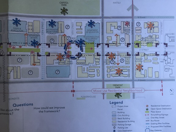
CADA (Capital Area Development Authority) is undertaking a process to activate O Street between 7th and 17th streets in downtown and midtown Sacramento. There was a community meeting at noon today, which I participated in. Not many people there, but there is also a meeting this evening which might gather residents who work during the day.
There are a lot of intriguing ideas and overall I think the draft framework is a good one. CADA said the diagrams and maps would be posted within a few days, so you will be able to see them at http://www.cadanet.org/projects/o-street-improvements-project.
Some comments I made:
the design needs to be compatible with the new light rail stations that will be constructed, probably in phases, to accommodate the new low-floor rail cars which require an 8-inch curb above the rails; the mini-high platforms needed for the current fleet of high-floor rail cars will eventually be removed, making for a much more pleasant street environment
rather than putting in bicycle facilities on O Street, separated bikeways on P Street and Q Street (partially complete) and N Street (not started) should handle most of the through bicycle traffic; instead, these things should be done to make the street bikeable without any special facilities:
speed limit 15 mph throughout
most sections become single-lane one-way, with narrowed travel lane; where two-way sections are needed (if at all), streets should be narrowed significantly
textured pavement, for streets or crosswalks or intersections, should either be sufficiently smooth to accommodate bicyclists, or have smooth pathways specifically for bicyclists
without bicycle-specific infrastructure, more of the right-of-way width can be devoted to pedestrians, sidewalks and the amenity zone; the pedestrian space will make the biggest difference in how the street is perceived
no section that is now closed to motor vehicles (9th to 10th and 11th to 12th) should be opened to motor vehicles, and no section that is currently one-way should become two-way
all corners should have bulb-outs (curb extensions) to calm motor vehicle speeds, reduce crossing distances, and preserve visibility at corners from parked vehicles; many corners are proposed for bulb-outs, but not all
raised intersections should be considered for all intersections
traffic on 15th Street (southbound) and 16th Street (northbound) must be calmed; it is currently difficult and hazardous for both walkers and bicyclists to cross through these intersections, traveling along O Street
The big issue, though, is that there is insufficient residents along the corridor, specifically between N Street and Q Street, to activate the corridor. More about that in my next post.
The improvements to O Street will be very expensive, if all are completed, but there are low cost items to start with, and I’m hopeful about seeing some of these in the near future.
Sacramento central city is booming with construction, which I consider to be a wonderful thing. Mixed use buildings, single lot apartments andhomes, state office buildings. But the construction is having a serious impact on walkability, and often bikeability. (Note: this post is not about road construction or about temporary closures, which also need to be addressed, but not today.)
Two examples, both of state developments, but with principles applicable to private developments, will illustrate the issues. For the new California Natural Resources Agency building between O and P, and 8th and 7th, the sidewalk, parking and one travel lane on the south side (P St) were removed from service. These are not being used in any way for the project. Perhaps they will be eventually, but in the meanwhile, presumably for the entire life of the construction project, they are just sitting empty and unused. For the new O Street office building at O and 12th, the sidewalk and parking were removed from the east side of 12th between the N-O alley and the O-P alley. The section to the north, where the building is being constructed, needs closure, as the underground level is being dug and the sidewalk will be replaced. But on the section to the south, which is being used for storing construction materials, do not need to be closed. There is plenty of space on this former parking lot.
12th Street construction closure
For some of the private construction going on, of which there are many examples, some closures are no doubt necessary. But the closures seem to be occurring from the very first day of construction to the very last day of construction, even though it is needed for only part of the time.
Construction companies are doing this because they can, out of convenience or laziness. And the city is allowing them to. Each construction project requires a traffic control plan, and the permit specifies allowable areas and time frames.
When I questioned the closure on the southern section of 12th Street, Matt from Construction Services in Public Works argued that since parking was removed, it was only fair that the sidewalk access be removed. His thinking was that fairness required making everyone lose something, and that the loss of parking was equivalent to the loss of sidewalk access.
This of course is a ridiculous argument. Parking is in no way equivalent to access. And priority must be given on all roadways to the most vulnerable users, which are in order of importance, pedestrians, bicyclists, and motor vehicle drivers.
At the recent Sacramento Active Transportation Commission meeting, Jennifer said that she though there might be guidance on access restrictions, but wasn’t sure, and would look into it.
In the meanwhile, let me propose:
For any roadway with more than one lane in a direction, space will be taken from a general purpose travel lane:
If a sidewalk or informal walking path is present, pedestrian access will be preserved by the creation of a temporary sidewalk protected by delineators or barriers.
If a bike lane or separated bikeway is present, access will be preserved by the creation of a temporary bike lane protected by delineators or barriers.
For any roadway with a single lane in a direction, space will be taken by closing the general purpose lane in one direction, with appropriate detours for motor vehicles:
If a sidewalk or informal walking path is present, pedestrian access will be preserved by the creation of a temporary sidewalk protected by delineators or barriers.
If a bike lane or separated bikeway is present, access will be preserved by the creation of a temporary bike lane protected by delineators or barriers.