Thanks for the website Mapping Inequality: Redlining in New Deal America, I have better copies of the Sacramento redlining map, which was produced in 1937 by the Federal Home Loan Bank Board and the Home Owners Loan Corporation (HOLC). These were government sanctioned zonings meant to guide banks to only loan to certain kinds of people in certain areas. Specifically, higher income white people.Though the official endorsement of the federal government eventually ended, the practice continued into the 1970s, and is with us still today. The best book on it is The Color of Law: A Forgotten History of How Our Government Segregated America by Richard Rothstein, which I highly recommend.
I had seen this map before, most likely from the posts of Bill Burg, but had not seen a high quality version, and had never found the GIS data. In 1937, Sacramento was a pretty small city, not going south past Land Park or north past Del Paso Heights, so the maps only cover a tiny part of what is today Sacramento. But as the city grew into other areas, the same practice redlining continued.
The first map below is the ArcGIS version, the second a scan of the original 1937 map.
Sacramento HOLC redlining map 1937 (click for pdf)original map, scanned (click for high resolution)
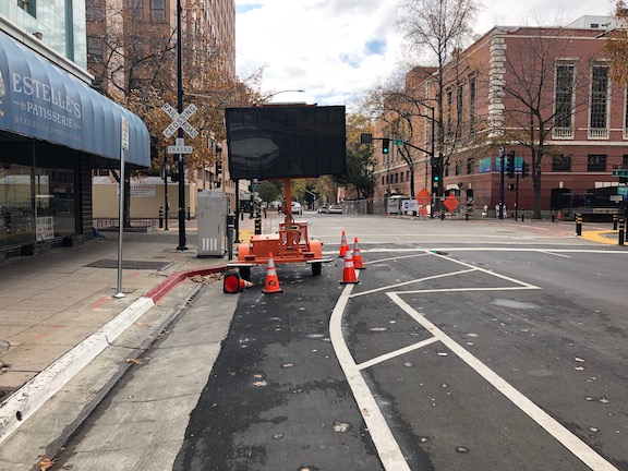
There has been a lot of discussion Twitter the last week about drivers speeding on roads, just because they can, with the streets mostly empty. Agreement has come in from a wide variety of places, but there are also doubters, who say this is not happening. So, I decided to pay more attention to what is going on. These observations are from Sacramento central city, east Sacramento, and south of Broadway to Fruitridge Road, but mostly central city.
On three lane one-way streets, egregiously poor driver behavior is rampant. It is less common on two lane one-way streets, but still noticeable. It is pretty much absent on two-way streets.
I took some time to observe drivers on two three lane one-way streets in the central city, J Street, and 12th Street, both of which I know to have speeding problems when they are not congested. Both locations had signals every block. I suspect driver behavior would be much worse on sections without signals every block, but have not done observations yet.
On J Street, 38% of the drivers were doing something significantly unsafe or obnoxious. On 12th Street, it was 45%. This was Sunday afternoon. What, specifically, was I seeing?
drivers going more than 10 mph over the speed limit (limit is 25 mph on these two streets), sometimes well over
muscle cars revving up to high speed between signals and then braking hard for the signal (usually, sometimes they just blew the red light); what I mean by muscle cars is vehicles with a horsepower rating far more that would ever be needed in a city
vehicles with exhaust systems modified to be very loud, and which were being driven in a way so as to generate that noise
drivers making right or left hand turns, against red signals, without really slowing down
I do not have a radar gun, though it would probably be a good investment. But I have spent many hours at speed display signs calibrating my perceptions of vehicle speed to the what the sign says. There is a speed display sign on 12th Street between H Street and I Street. Though most drivers (the ones not mentioned above) were going no more than 25 mph, some were going up to 35 mph, accelerating in just that one block, and several drivers pegged the display, which means it blanks out the speed and displays a message such as ‘too fast’, which on this sign I think means over 35 mph. How fast would they have been going if the signals were not here?
You might have some hope that the police would enforce against this. Sorry to dash your hopes, but every single Sacramento Police Department vehicle I saw today was going well over the speed limit. Not just a little, and not responding to calls (no siren, no lights), but well over.
Of course the long-term solution to this is not enforcement, but reconfiguring roadways to eliminate ALL three lane (or more roads), and to convert most one-way roads to two-way. The city is working on some of that, but at a snail’s pace, as streets are being resurfaced. We need to accelerate this change, to keep all of us safe, today, during the pandemic, and beyond. Yes, I am even including drivers and their passengers in the ‘us’, as they are as much in danger from this behavior as walkers and bicyclists.
I know that there are also people out there driving for valid reasons, going to essential jobs, to medical care, to buy groceries (though a lot of them could be bicycling). The best thing we can do for those people is to remove the others.
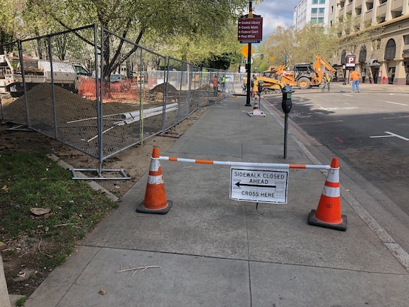
An new housing development at 16th Street and E Street (remember, I’m not against housing developments) has significant problems. At the southeast corner of 16th and E, the corner has been completely blocked by construction barriers and fencing, so there is no safe wait space for people using the crosswalk, and therefore both crosswalks should be closed. There should be a barrier and signing on the east side crosswalk over E Street, and there should be a barrier and signing for the south side crosswalk over 16th Street. Neither are there.
16th Street & E Street, no crosswalk barrier
The project also has problems on 16th Street approaching from the south, where the sidewalk end, but a small sidewalk closed sign is not visible because it is on a canted fence, and there is no advance warning at F Street.
16th Street northbound, no visible signing
On E Street westbound, there is a construction fence with no sidewalk closed signing, nor is there any advanced signing at the last safe crossing at 17th Street.
E Street westbound, no signing
This property and development is apparently owned by SKK Development, Sotiris Kolokotronis, and is called Eleanor Apartments.
The apparently dead redevelopment project at 700 16th Street, the old Clarion Hotel, which occupies the block between 16th and 15th, and H Street and Government Alley, has closed sidewalks for a long period of time, even though nothing is happening there. The sidewalks closed are on H Street, the entire block, and 15th Street, the half block. As seen in the first photo below, there is enough pedestrian traffic on 15th Street to have worn a path in the sidewalk buffer. The solution here is to require the developer to remove this fence. If fencing is needed, which is doubtful on this side of the building, it should be on the property and not in the buffer. Re-opening this piece of sidewalk until such time as there is active development is the right thing to do.
15th Street use path, north of H Street, old Clarion Hotel
On the northwest corner of 15th Street and H Street, the corner could have been left open so that the two crosswalks could be safely used, but it was not. Instead, a sloppy fencing job leaves a sidewalk too narrow for ADA use.
15th Street & H Street, northeast corner, no ADA access for crosswalks
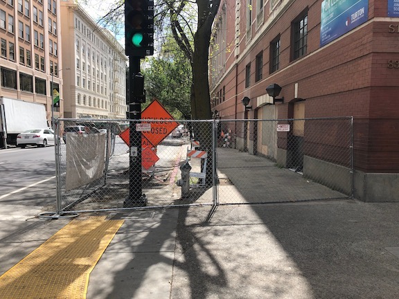
The sidewalk closure on H Street might need to remain because there is building access on this side, but it should be properly signed approaching from the east, which is is not.
H Street & 16th Street no signing
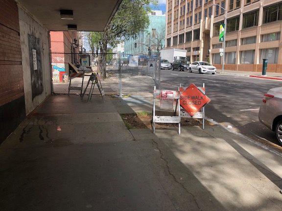
Lastly, on 15th Street southbound at Government Alley, there is a fence but no signing, and there is no advance warning at G Street that the sidewalk is closed ahead.
15th Street at Government Alley, no signing
This property is apparently owned by SKK Development, Sotiris Kolokotronis, and is called The Bernice. This failure to accommodate walkers is both the fault of the owner/developer, for the poor job of fencing and signing, and of the city for failing to monitor the situation (and perhaps for allowing it to exist in the first place). This also points out that there must be bonds for construction zone fencing and signing so that if a owner/developer fails to proceed with development, the city can go in and partially or fully restore access at the developer’s expense.
Note: updated 2020-03-28 to correct lane descriptions and add a photo of the lane shift.
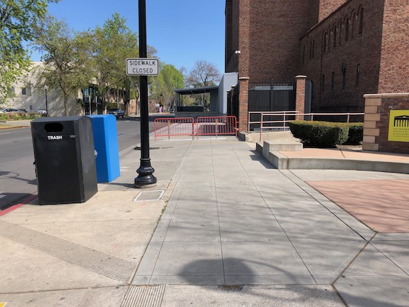
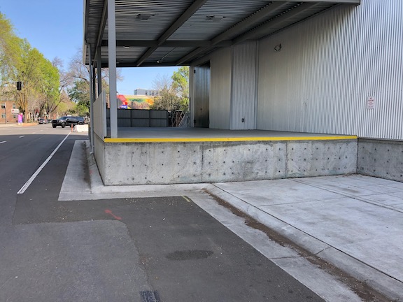
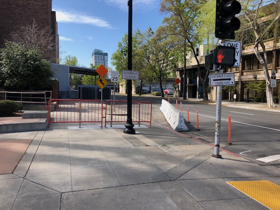
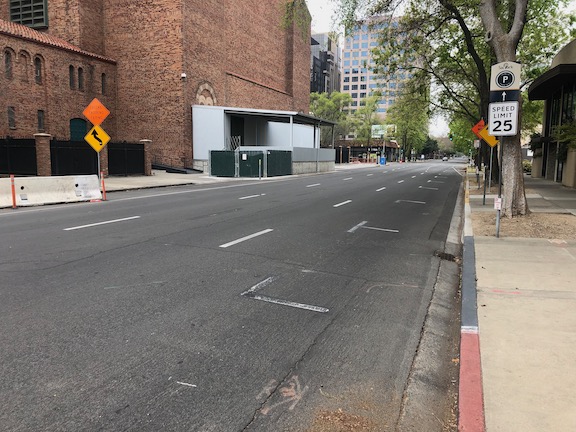
On the south side of I Street, between 15th Street and 16th Street, the city has permanently closed the sidewalk. This was to construct a loading dock for Memorial Auditorium. I had noticed the construction going on there, the first phase of the city’s project for the convention center and community center theater, and just assumed things would be returned to normal when construction was complete. How wrong I was. I was flabbergasted when I saw this. The loading dock sticks quite a ways into what used to be the public right of way, erasing the sidewalk and two parking lanes (the general purpose lanes were shifted to the right). The loading dock is concrete, intended to be there forever. See the photos below.
If the loading area was really than important, and could not be provided anywhere else, the city could have set things up for easy temporary closure of some of the street so as to allow loading when needed. They did not, they made it permanent.
I have walked by here, on the sidewalk, when events were going on at the Memorial Auditorium and there were a lot of walkers using this sidewalk. I imagine for a lot of other uses as well.
Also note that the ‘ bike lane’ stripe does not meet standards for a bike lane because it is immediately adjacent to a hard barrier and fence, so requires shy distance not provided. So that means when there are eventually bike lanes on I Street, this will be a gap, permanently.
What the fuck were you thinking, City of Sacramento?
I Street, south side, east of 15th StreetI Street, south side, east of 15th StreetI Street, south side, west of 16th StreetI Street, south side, west of 16th StreetI Street westbound, lanes shifted right
JUMP (Uber) pulled out of the Sacramento region (the cities of Sacramento, West Sacramento, and Davis) in order to meet their concerns about COVID-19. They announced this on March 18, though the bikes and scooters were mostly gone two days before that (except for a few dead ones they still haven’t picked up because without GPS they don’t know where the devices are).
Of course the bikes and scooters were getting used a great deal for recreation and socialization, but they were also being used by many people to get to and from work, and to go grocery shopping (small loads) and other errands. Some of these people do not have an alternative, they do not own a bike, or their bike is not functional. I don’t know what the level of participation was in the JUMP Boost program for low income individuals, but I suspect most of those people do not own cars, or cannot afford to keep them running, so JUMP bikes were a major transportation solution for these people. JUMP pulled the rug out from under these people. As a private company, they are entitled to do so. I will note that Spin scooters still seem to be available, and Spin has publicly made a commitment to continuing to offer scooters.
I am not one of the people depending on JUMP bikes. I have a bike, and using JUMP was just a matter of convenience for me, letting me make faster trips to the store and other errands, and during the warm/hot months, get there without a sweat. But there are others not so fortunate.
I consider bike share to be a part of the transit system for Sacramento. Both JUMP and SacRT also seem to see it this way – they cooperated to install JUMP charging hubs at a number of light rail stations in the city of Sacramento. But now we are without that first mile/last mile option (as it is called, though bike certainly allow more than a mile). Just as transit is funded by the public (as well as user fees), bike share, and probably scooter share, should be funded by the public (as well as user fees).
Going forward, the city needs to give serious thoughts to whether it is acceptable to have a private system as the only provider of mobility devices. Coronavirus is only one ‘natural’ disaster emergency. There will be others from other causes that demand we continue to have a functional transportation system. I am not suggesting that JUMP be eliminated in favor of a public system. JUMP (Uber) has had its issues, but when I think back to where we were before SoBi > JUMP, I can’t doubt it was a good thing. Certainly the fairly rapid expansion of the number of bikes and scooters, and the service area enlarged to much more (though not all) of the city of Sacramento, could not have happened without private investment.
Maybe the city can work out an agreement with JUMP that a certain number of bikes would remain available through any disaster. And through education, make it clear that this limited set of bikes if for Boost members and people in essential occupations.
I don’t know the best solution, and am happy to hear from others. What I do know is that if we come out the other side of the pandemic without having talked about this, we have failed to plan for the future and ensure an effective and equitable transportation system.
Dr. Destiny Thomas (@DrDesThePlanner) posted on Twitter today that if we are serious about bicycling as an alternative during these times, we need to address how to get bikes into the hands of those who don’t have them and can’t afford them. I agree!
So, now that I’ve spent several posts complaining, on to solutions. The city is working an ordinance for construction zone handling, but I have not seen any draft documents. When something is available, I’ll add it.
The City of Oakland has what is generally considered to be the model guidance (http://www2.oaklandnet.com/oakca1/groups/pwa/documents/memorandum/oak062315.pdf), though Seattle also has something good that I’ve not tracked down yet. Sacramento could do well to simply adopt the Oakland guidance, but it is pretty radical for Sacramento, so I’m expecting something weaker to come out. Let me say what I think is most important.
Let me credit Robert Prinz of Bike East Bay for publicizing the guidance (he may have also had a part in developing it, not sure about that), and for monitoring compliance and publicizing failures. He is an inspiration for me.
Management:
Responsibility for approving traffic control plans should be removed from Construction Services and placed in another division of Public Works that will actually ensure quality traffic control plans and enforcement as needed. Construction Services has demonstrated that they cannot be trusted with this responsibility. They continually bias for motor vehicle traffic and drivers, and against walkers and bicyclists.
Construction sites should be inspected on a regular basis by city personnel, to ensure that they have correctly installed the signing and barriers specified in their approved traffic plan, and that these are maintained until completion of the project.
Fines will be imposed on construction companies that do not correct problems within 12 hours of reporting to the city, by city staff or by citizens. If the construction company fails to correct the issue within 48 hours, the construction project should be shut down.
Sidewalks and bike lanes:
For any roadway with more than one general purpose travel lane in the same direction, it shall be automatic that temporary sidewalks and bicycle lanes will be placed instead one lane.
For any roadway with parking lane on the same side as the construction zone, it shall be automatic that temporary sidewalks and bicycle lanes will be placed in the parking lane.
For any roadway where the bicyclist and/or pedestrian traffic is above a certain level (I’m not sure what the number should be), if no accommodation can be made by using a parking lane or general purpose travel lane, then the road will be closed to motor vehicle traffic in one or both directions for the duration of the project.
Crosswalks:
ADA compliant barriers and signing will be used at ALL construction projects which close a crosswalk, no matter what the duration of the project. For any closure of over a week, fixed metal barriers should be used (see photo below). Plastic barricade poles or construction tape will never be used by themselves to mark a closure.
Unless the closest safe crossing is clearly evident from the point of closure, wayfinding signs will be included specifying the shortest distance and safest crossing.
ADA detectable crosswalk closure barrier
Signing off for now with the construction zone topic. I found several more problematic locations on my walk this morning, but I need to take mental break from this, and talk about other things.
As always, I invite your comments and additions. Stay safe walking and bicycling out there, but don’t stay home. Your sanity requires being outside, or at least that is my opinion.
I recognize that all the examples of construction zone problems (and a few done right) have been central city Sacramento. This is for two reasons, one is that I live downtown, and when I’m out on my physical distancing walks, these are the places I’m seeing. The second is that a lot of the construction happening in the entire city is happening in downtown, particularly the projects which require extensive closure of sidewalks, and bike lanes. If you have examples from other places, please let me know (allisondan52@gmail.com) and I will try to get there to take photos and analyze the situation. For those of you in the county, well, that is too much to tackle, and in a relative sense the county is economically moribund, so much less construction is going on.
Please don’t take my criticism of construction zones at being a criticism of construction. I love that there is a lot of construction going on. In midtown, most of the construction is housing, and nothing could make me happier. In downtown, there is more office construction than housing construction, and that is not a good thing, as it further exacerbates the jobs/housing imbalance in downtown. Except right around the arena, and in old town, there are few businesses and almost none are open on weekends because there is so little housing as compared to offices.
Below, a few last examples, before I move on to solutions. The first was a temporary issue, but it is illustrative of the problems. A mobile message board was placed in the center of the separated bikeway on 9th Street, even though there was a cross-hatched area immediately adjacent where is could have been placed, without constraining the bikeway or the general purpose lanes. I am not sure whose mistake this was, but anyone with a brain would know that this was the wrong place to put it. The sign was moved within a day of my reporting it to the city, but these are things that should be done right, not relying on citizens to correct mistakes.
9th Street separated bikeway, mobile message board
There is currently a utility project along the north side of L Street between 13th St and 10th Street. The photo belows shows the situation at L Street & 11th Street. The signing is acceptable, though the use of plastic barricade poles is not, but the issue is that the detour doesn’t tell you how far. A block? Several? Where is the nearest safe crossing? As referred to in the What? Cross Where? post, the west side of this intersection has a pedestrian prohibition, but you can see someone crossing here. And why not? What else could they do?
L Street at 11th Street, signing but no information, improper barricade
This next one was a temporary closure on 10th Street. There is signing, but rather than being placed at the point where a walker could either choose to cross to the east side of the street, or to walk through Cesar Chavez Plaza and back to the sidewalk, it was placed where the closure starts. Again, the plastic barricade poles do not meet ADA requirements because they are not detectable for person with vision limitations. While some would say, well this is just temporary, for a day, and standards should be lower, I disagree. It may be perfectly acceptable to not provide an alternative route for a temporary closure, but the signing and sign locations should be the same for all closures, whether they last an hour, a day, a week, a month, a year.
10th Street, west side, temporary closure
And one last example, though I have dozens more. The 3rd Street Sewer project has closed off 3rd Street from S Street to U Street. An attempt has been made to keep the sidewalks open, and I seriously appreciate this effort, as many construction projects would simply close off the sidewalks along with the street, and not think twice. However, construction tape does not a safe route make. The detour signs are clear, but no attempt is made to provide a detectable barrier. And construction tape…
Yet another. There is a construction project, or at least a fencing off for future construction, at 830K, a long abandoned building. Along 9th Street, a fence has been put up where there used to be a bus stop, extending from K Street to and including Kayak Alley.
Southbound at K Street, there is no signing on the fence at all. This is not a major flaw, as it is obvious the sidewalk is closed, but there is no information about how far the closure extends.
9th Street southbound at K Street, west side (830 K)
From the south end, things are much worse. There is no signing at L Street to indicate there is a closure ahead. When you get to the closure, there is a random assortment of barricades, each of which is non-ADA compliant, and not indication which way to go. If Kayak Alley were open, it would at least offer an alternative, but the alley is closed.
9th Street, northbound at Kayak Alley, west side (830 K)
The worst part of this is that, so far as I can tell, nothing is going on here. The sidewalk, and bus stop, was closed off by fencing, but since then, nothing is happening. The point here is that there should be requirements placed on construction projects that if they stall out, the sidewalks must be returned to their previous open condition until such time as construction resumes.
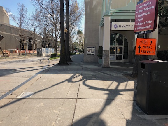
The convention center and community center theater project (3C) project did a very poor job of preserving access for walkers and bicyclists at the beginning. Some issues have been resolved, but some never have, though the project has now been going on for just less than two years.
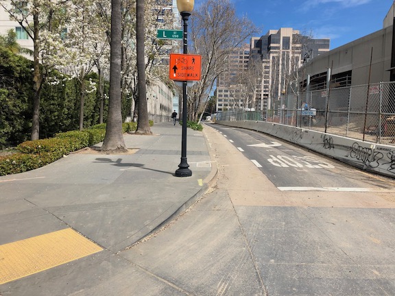
The most significant issue is that there was no provision made for northbound bicyclists on 13th Street, passing the construction between L Street and J Street. 13th is a major bicyclist route of travel, and the city knew this before the construction started. But the original traffic plan did not address this use at all. After public complaints, a sign was installed on the sidewalk for northbound bicyclists, photo below, but not the southbound. The numerous walkers using this sidewalk, adjacent to the Marriott and Sheraton convention facilities, were confused to see bicyclists on the crowded sidewalk. After more public complaints, a sign was added southbound, the second photo, though it is placed in a location where people coming from K Street would not necessarily see it. As you can see in the first photo, the sidewalk is narrow just north of the crosswalk, so bicyclists heading north are brought into immediate conflict with pedestrians heading south, many of whom are headed to the crosswalk over L Street. Of course having an angled ADA ramp here, rather than the two-to-a-corner design that should be used wherever there is significant pedestrian traffic, makes things worse.
Of course the best solution here would have been to just close 13th Street to motor vehicles between K Street and L Street, leaving the narrowed roadway available for two-way bicyclist traffic. There are far more bicyclists using this route than private vehicle drivers. Despite that, the city biased in favor of drivers.
13th Street northbound at L Street13th Street southbound at K Street
One issue on which progress was made was the southeast corner of J Street and 13th Street. Initially this corner was closed, giving walkers only one choice of how to cross, despite this being one of the most heavily used intersection crossings in the city. There was no reason to close the corner off, the area behind the fence was never used for construction. After about a year and a half, the corner was re-opened, photo below, so that walkers have a choice of routes. Note that when the city finally worked on this corner, the work was not done behind the fence, but the fence was moved and then the sidewalk and ramp work done by closing off the corner until it was done.
J Street & 13th Street, southeast corner, finally re-opened
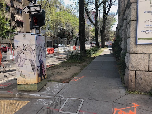
On the east side of the project, issues remain. The sidewalk from J Street south along 15th Street has no signing indicating that it is closed ahead, see photo. When you get half way, there is just a fence blocking access. In daylight, you can see the fence ahead, but a limited vision person and anyone walking at night would not see the fence until they got to it. This is simply unacceptable.
15th Street west side, southbound from J Street, no signage
There are several other less serious issues around the east and south sides. At K Street & 15th Street, there is no signing to indicate how to get to the other side, to go either northbound or southbound. This one is not hard to figure out, at least for sighted people, but it was still not done correctly. This crosswalk ramp should have been barriered off, just like the ADA compliant barriers in the previous post, since it only leads to a closed crosswalk.
On the south side of the project, there are plastic barriers for the crosswalk over 14th Street at L Street, and for the crosswalk over L Street on the west side of 14th Street. These barriers were knocked over months ago and have not been put up again. There were not sufficient to begin with, but laying down on the ground, are both useless and hazardous.
14th Street at L Street, failed barrierL Street at 14th Street, west side crosswalk, failed barrier
I’m going to call this one a failure on the part of both the construction company and the city: the construction company for failing to monitor and maintain the traffic control devices for which they are legally responsible, and the city for failing to monitor the construction company. Blame all around!
And lastly, the closure of a lane on L Street for the construction was not handled well. As you can see, there is a narrow crosshatched area the length of the block. One might reasonable choose not to go this way, but then again I see people going this way every day, both walking and bicycling. I am not sure how this should have been handled, but there must be a better solution. Of course one solution would have been to continue a temporary pedestrian walkway on the north side of the street, set off by concrete barricade, and requiring only a simple fence to separate the walkway from the construction site. If more street width was required, parking could have been removed from the south side and the general purpose lanes shifted to the left. Note there there never was a bicycle lane present in this block, it is dropped at 15th Street and the traffic sewer 3-lane roadway continues west.
L Street westbound at 14th Street, narrow shoulder
In closing, this construction project is probably the worst in the city (though there is competition). It does not involve a private property owner, it does not involve a state construction project, it is a city project on city land. There is simply no excuse for such poor walker and bicyclist accommodation. It is a big middle finger to those to who don’t drive.