hazardous bikeway on 19th St

This is Central City Mobility Project update #19.

I have mentioned the problems with the gutter pan on several blocks of the new bikeway on 19th Street being so deteriorated that the effective width of the bikeway is only about two feet. It is clear that the city did not look at the existing conditions of the gutter before deciding to place the bikeway in this gutter. But, this is not an easy thing to fix. There are at least four blocks that are unacceptable, but it will probably require reconstruction of the gutter pan to fix it.

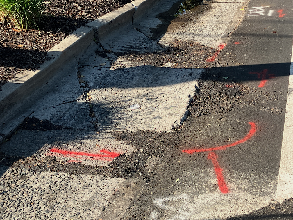
What can be fixed, but has not been, is the root heave in the 19th Street bikeway at Matsui Alley (note that Matsui is discontinuous, and is present only on the west side of 19th Street; the alley does not exist on the east side.) The photo below shows the root heave, but doesn’t really emphasize how big it is. There is a four inch displacement. This is a pavement flaw that could easily cause a bicyclist to crash. I don’t know whether the orange paint marking is from the city or bicyclists, but orange paint is not visible at night, and even in daytime it doesn’t make clear what the rider should do to avoid the hazard.

19th St bikeway at Matsui-Alley root heave
19th St bikeway at Matsui Alley root heave

I have reported this issue to the city 311 app several times. I know of at least two other bicyclists who have reported it multiple times. The city 311 incident map shows only my latest report (230805-1907594), which means that the city has closed all the other reports without any action.

Allowing this type of hazard to exist, when it is a known hazard, particularly in a location designed to attract bicyclists, is criminally negligent. Let me repeat that for the idiots in Public Works, who seem to be hard of hearing – CRIMINALLY NEGLIGENT.

If you are a bicyclist who is using 19th Street, I encourage you to NOT use the bikeway in this block between Capitol Avenue and N Street. Ride in the middle of the general purpose travel lane instead. And if you have the time, file a 311 report on the hazard. It will become increasingly difficult for the city to claim it didn’t know about this problem (by closing the reports without action), the more people report it.

SacCity street design standards

I had recently posted on the design for alley sidewalk crossings, based on a document from the City of Sacramento website. I shortly thereafter discovered that there are at least two sets of standards. The Department of Utilities, on the Development Standards page, has a Standard Specifications document which includes some text about streets, and the Transportation appendix of standard drawings which contains the diagram referenced. If you look at the text document, you will notice that it does not link itself to the Department of Utilities. Who wrote it, who would you contact about it? Who knows. Why the Department of Utilities has its own designs, separate from Department of Public Works, which has assigned responsibility for transportation, isn’t clear at all. On the positive side, though, this document was updated November 2020.

The Department of Public Works has its own Section 15 – Street Design Standards, part of the Design and Procedures Manual, linked on the Public Works Publications page. This is the document I discovered after using the Department of Utilities document. On the negative side, this document was last updated in June of 2009. Fourteen years ago. Again, there is no attribution to department in the body of the document. I only know/think this is a Public Works document because it is linked from a PW page.

There have been immense changes in street design best practices in that time. Most of the diagrams are overviews of arterial and collector roadways, very little about other streets. Bike lanes of any sort? Nada. ADA ramp details? Nada. Protected intersections? Nada. Curb extensions (bulb-outs)? Nada. Traffic calming infrastructure? Nada. The text of the document does contain references to a few of these issues, but without corresponding diagrams, there really is no guidance at all.

In searching for design diagrams, it appears there are additional designs scattered across the city website, some of them having to do with subdivisions, which seem to be treated separately from other street design. Let me say that this is not at all clear. The city website contains many documents without attribution to the department which created it. The city search engine is one of the poorest I’ve ever seen, and when it finds a document, it is almost impossible to tell where it came from or on which webpage one might find it.

At the SacATC (City of Sacramento Active Transportation Commission) meeting on 2023-03-16, staff presented an Introduction to Current Active Transportation Efforts. Under Projects, item 6 is ‘Street Design Standards Update: website expected in Fall 2023’. I spoke at the meeting about the weakness and antiquity of the current standards, and about the confusion over which set of standards is being talked about. City code, in Title 17 Planning and Development Code also has references to street design, but no linkage to the corresponding street design documents or diagrams. I don’t think staff realized how big a mess this is. It is not just the Public Works document that needs to be updated, but all city references to street design pulled together and properly referenced and linked.

A post in the near future will provide my ideas about what a street design manual ought to look like.

cover page of Section 15 - Street Design Standards, of the Public Works Design and Procedures Manual

Sacramento transportation projects

This is the current list of Public Works transportation projects in the City of Sacramento. I know about a few of these projects, but many of them I don’t know anything about. It would be worth exploring all of them to see what the implications are for walkability and bikeability, but where would I find the time? Some projects have their own document or page on the city website, but most of them don’t, at least that I’ve been able to find, so I presume these would require getting in touch with the city to get the documents.

SacCivilProjects_2013-01