Central City Mobility: 19th & O curb extensions

More information on the curb extensions (bulb outs) being installed on the northeast and southeast corners of the intersection of 19th Street and O Street, as part of the Central City Mobility Project. I questioned this location for curb extensions because 19th Street with have a parking protected separated bikeways on the left side (southbound) of 19th Street. (Central City Mobility update)

I received a response from the engineering firm for the project:

This is in response to your inquiry as to compatibility of the subject intersection revisions and parking protected bike lane. The design does account for the bulb outs at the intersection. Unfortunately, due to the space restrictions resulting from the bulb outs, it won’t be possible to provide parking protected all the way around the bulb outs. However, we are providing a transition of the bike lane at the intersection. Please take a look at the following striping design for the intersection. North is to the right with 19th Street running left to right. Hopefully this will give you a better feel for the plan:

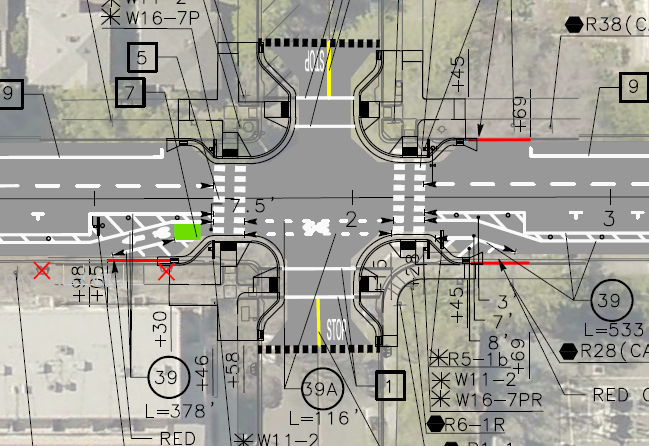
Any reader of this blog will know that I love curb extensions. What confuses me is why this location would have been selected by the city over many other potential locations. Perhaps some of the reason it that the crossing at O Street has a moderately high walker count, but does not otherwise have a traffic signal or pedestrian signaling such as a RRFB. It is possible that the city thought these four corner curb extensions to be the most practical way of increasing safety for walkers and bicyclists crossing at this point.

The design of bringing the separated bikeway out adjacent to the general purpose travel lane, as a bike lane, is not ideal but not particularly unsafe. In fact some bicyclists prefer this design, because it increases the visibility of bicyclists by motor vehicle drivers, so that they are not ‘hidden’ behind parked cars. Though daylighting of the intersection approach can accomplish the same objective.

I would like to see green skip paint continuing through the intersection in the bike lane. These are often painted as discontinuous green rectangles with sharrows stenciled on top, called green-backed sharrows. The sharrows are out of favor with most bicyclists and some traffic engineers, I think this is a valid use of them. The main purpose of green paint (it has no legal meaning) is to increase driver awareness of bicycle facilities by highlighting conflict points, and this is definitely a conflict point.

A number of related posts are in the category: Central City Mobility Project.

surface parking to residential

Wasted space for parking. This was once residences, and should be again.

Part two of posts about O Street activation, but also of more general applicability. See also my related post No more pure office buildings downtown.

The activation of O Street under the CADA-led ‘Envision O Street: A Community Planning Process to Transform the Streetscape‘ effort will be only partially successful unless there are a lot more residents along O Street and the adjacent neighborhood to activate it. As it currently stands, the street is largely dead evenings and weekends. Even the homeless folks don’t much like hanging out there.

So, forthwith, my modest proposal. All surface parking lots along N, O, P and Q streets will be transferred to CADA and developed for residential and/or mixed use. These developments might even include some office space, but no development would be purely office. We have enough state office space as it is, and we have enough parking garages (decks) as it is. Significant parts of the parking decks are empty even on weekdays, and they are completely wasted space the rest of the time. Many of them are even locked up evenings and weekends, so they could not be used even if people wanted them to be used. The state seems to not care about whether downtown and its part of midtown (extending to 17th Street) are dead. It sees downtown as just a collection of office buildings, and is fine with the buildings and streets being empty off work hours. The state also believe that it is their responsibility to provide unlimited parking for their employees, no matter how much that parking decreases the livability of the places they work. I’m not sure if these attitudes come only from DGS (Department of General Services) which manages state property, or is a more general view, but it is wrong. The state should be encouraging workers to get out of their cars and onto transit (light rail runs on O Street), bicycles and foot, not providing them free and low cost parking. The state should be encouraging livability, not thwarting it.

All surface parking lots along N, O, P and Q streets will be transferred to CADA and developed for residential and/or mixed use.

O Street Activation

CADA (Capital Area Development Authority) is undertaking a process to activate O Street between 7th and 17th streets in downtown and midtown Sacramento. There was a community meeting at noon today, which I participated in. Not many people there, but there is also a meeting this evening which might gather residents who work during the day.

There are a lot of intriguing ideas and overall I think the draft framework is a good one. CADA said the diagrams and maps would be posted within a few days, so you will be able to see them at http://www.cadanet.org/projects/o-street-improvements-project.

Some comments I made:

  • the design needs to be compatible with the new light rail stations that will be constructed, probably in phases, to accommodate the new low-floor rail cars which require an 8-inch curb above the rails; the mini-high platforms needed for the current fleet of high-floor rail cars will eventually be removed, making for a much more pleasant street environment
  • rather than putting in bicycle facilities on O Street, separated bikeways on P Street and Q Street (partially complete) and N Street (not started) should handle most of the through bicycle traffic; instead, these things should be done to make the street bikeable without any special facilities:
    • speed limit 15 mph throughout
    • most sections become single-lane one-way, with narrowed travel lane; where two-way sections are needed (if at all), streets should be narrowed significantly
    • textured pavement, for streets or crosswalks or intersections, should either be sufficiently smooth to accommodate bicyclists, or have smooth pathways specifically for bicyclists
  • without bicycle-specific infrastructure, more of the right-of-way width can be devoted to pedestrians, sidewalks and the amenity zone; the pedestrian space will make the biggest difference in how the street is perceived
  • no section that is now closed to motor vehicles (9th to 10th and 11th to 12th) should be opened to motor vehicles, and no section that is currently one-way should become two-way
  • all corners should have bulb-outs (curb extensions) to calm motor vehicle speeds, reduce crossing distances, and preserve visibility at corners from parked vehicles; many corners are proposed for bulb-outs, but not all
  • raised intersections should be considered for all intersections
  • traffic on 15th Street (southbound) and 16th Street (northbound) must be calmed; it is currently difficult and hazardous for both walkers and bicyclists to cross through these intersections, traveling along O Street

The big issue, though, is that there is insufficient residents along the corridor, specifically between N Street and Q Street, to activate the corridor. More about that in my next post.

The improvements to O Street will be very expensive, if all are completed, but there are low cost items to start with, and I’m hopeful about seeing some of these in the near future.

Crocker Art Museum connecting to Crocker Park

Crocker-planning_288

Crocker Art Museum is undertaking a community visioning and planning process to develop and implement new ideas for the area around the museum and park, and particularly connections between the two. Workshops were held earlier, and now the museum is seeking feedback on some initial conceptual design to be presented at three workshops:

The museum says “At the presentations, you can also learn about a comprehensive plan for public art and art experiences that will unify the districts abutting the riverfront by creating pedestrian friendly pathways, linking art, entertainment, employment, and recreation with new residential developments along the Sacramento riverfront. This effort to create a vibrant new art link between Sacramento and West Sacramento will have Crocker Park at its center.”

Whether you are a visitor or a member (I am), this project could not only significantly improve the area around the museum, but show another way forward than our car-dominated spaces in Sacramento.

My comments to the museum follow.

Read More »

Sacramento Riverfront Reconnection, Phase 1

2nd Street extension to Capitol Mall

SACOG in the 2013 funding round allocated $9M to the Riverfront Reconnection project in the City of Sacramento. This phase extends 2nd Street from Old Sacramento to Capitol Mall, providing an easier access to Old Sacramento, and also adds sidewalks to O Street and improves sidewalks and bike lanes on Capitol Mall between 3rd Street and the Tower Bridge. The overall purpose is to create or restore connections between downtown Sacramento and Old Sacramento which were severed by Interstate 5.

Read More »