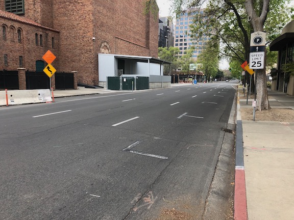
The H Street Bikeway project extends from 5th Street to 10th Street along H Street, and along 10th Street from I Street to H Street. It is intended to improve transit connectivity by double-tracking two blocks of light rail between 5th Street and 7th Street, and to improve bicycle access by providing a two-way separated bikeway (cycle-track) on H Street, which links to bikeways or bike lanes on 9th Street (southbound) and 10th Street (northbound). The project provides a reasonable solution, though it could be improved in a number of details (see H Street Bikeway: overview).
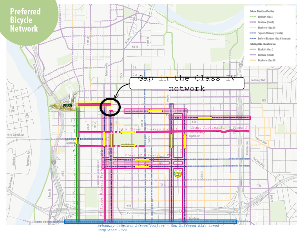
A map in the SacATC presentation shows the bikeway network in the central city, highlighting the gap on 10th Street from I Street to H Street.
Preferred Bicycle Network, showing gap on 10th St between I St and H St (from SacATC presentation)
It does not highlight the glaring gap on I Street between 12th Street and 10th Street. The separated, parking-protected bikeway on I Street, that starts at 21st Street, ends at 12th Street (it is just a bike lane in front of the fire department just west of 13th Street, but resumes further west).
For a bicyclist wanting to access the proposed two-way separated bikeway on H Street, they must use regular Class II (paint only) bike lanes from 12th Street to 10th Street, then proceed north one block in a buffered bike lane to H Street. I Street between 12th Street and 10th Street is three general purpose lanes. As it typical of any three-lane one-way street, motor vehicle speeds are well above the posted speed limit of 25 mph, except when congested. By the way, it is not posted at all in this section, though the change from two lanes to three lanes at 12th Street would make posting logical if not imperative.
There are other gaps, including 9th Street south of Q Street, and L Street and N Street. The map refers to a L & N Street Bikeways Project, but neither the planning or engineering sections of Public Works seem to have a webpage on that project. Strangely, the streets adjacent to Capitol Park are shown as Class II, paint only bike lanes, though these two sections without mid-block driveways are the most logical place for separated bikeways in the entire city.
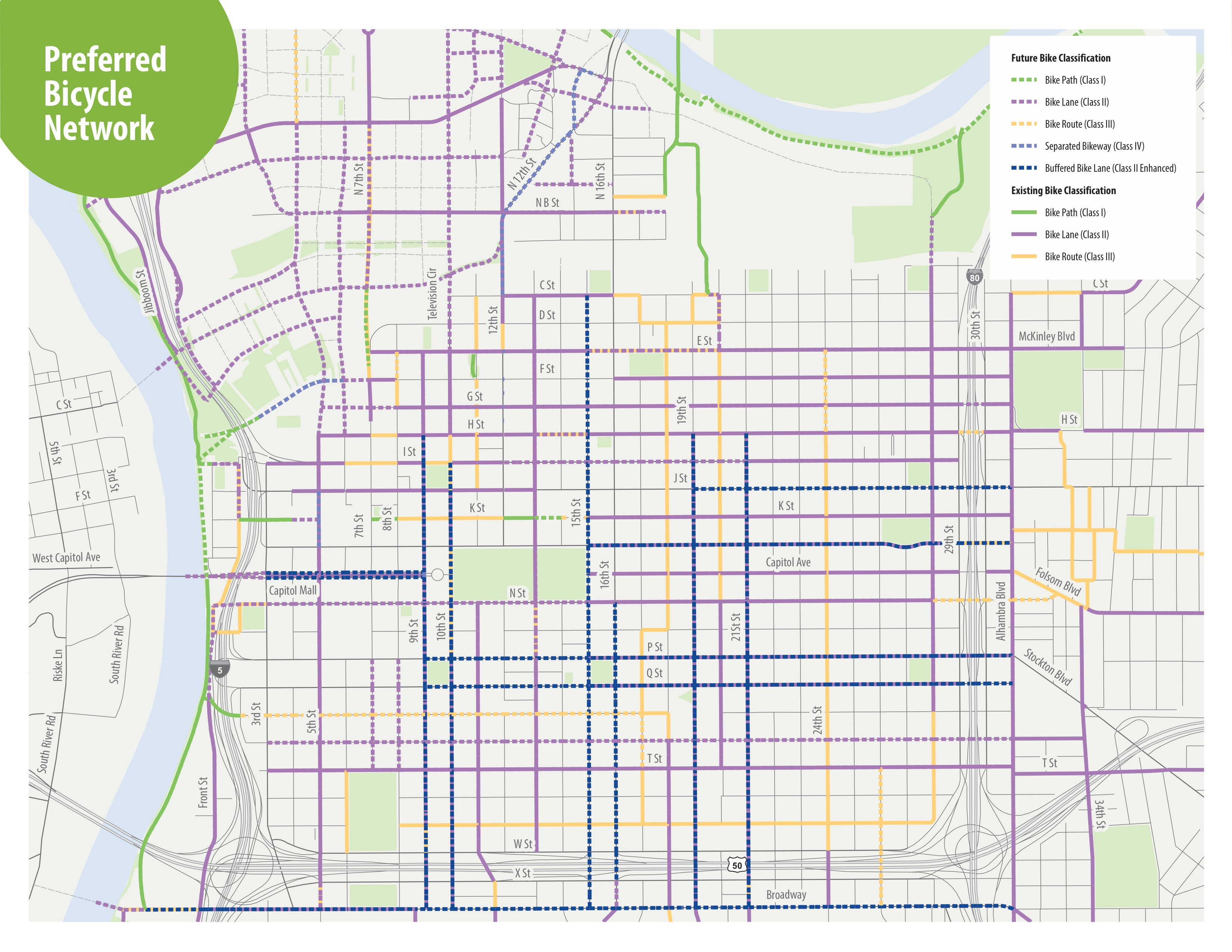
The map from the H Street Bikeway project presentation at SacATC was adapted from an old Grid 3.0 map (2016), below.
Grid 3.0 map of central city preferred bicycle network
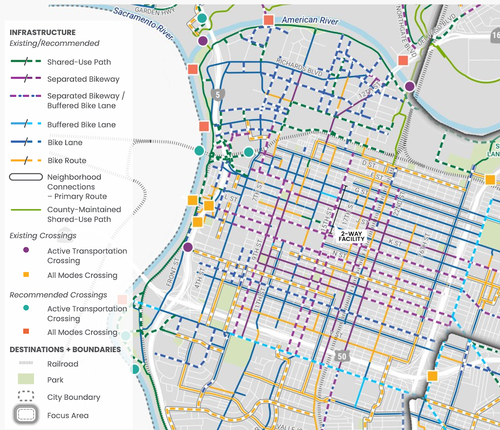
A more up-to-date map, with legend, is in the Streets for People Active Transportation Plan, page 80, ‘Figure 30 – Recommendations for People Biking in Central West Sacramento’, excerpted below. This map shows a separated bikeway (purple) continuing from 21st Street to 9th Street.
Work is occurring on I Street this week. The street has been marked from 21st Street to 12th Street, and some of the white striping has been completed. No green paint yet. This section is all right side of the street bikeways.
The design is rather erratic:
21st Street to 20th Street, parking protected separated bikeway
20th Street to 19th Street midblock, bike lane
19th Street midblock to 16th Street, buffered bike lane
16th Street to 13th Street, buffered bike lane
13th Street to 12th Street, parking protected separated bikeway
At the intersection of 21st Street and I Street, there are markings for dashed green bike lanes on the west, south, and east legs, adjacent to the crosswalks (not yet painted). No sign of the promised bike signal yet. The markings imply to me that bicyclists continuing north on 21st Street will have to make a two-stage crossing, first across 21st Street, and then across I Street. This is not what was advertised, which was that bicyclists would have an exclusive signal phase during which they could go to any of the three destinations without any moving motor vehicle traffic. To to seen.
21st St & I St intersection bike lane markings
At 20th Street, the street becomes three motor vehicle lanes (general purpose travel lanes) and a curb-side regular bike lane. I’m guessing this is to provide stacking area for motor vehicles when trains are crossing. Makes some sense, but it also makes the bikeway erratic, and will encourage poor behavior as drivers speed into the third lane, and then have to merge back into two lanes.
I St at 20th St, unprotected bike lane and three motor vehicle lanes
At 16th Street, the street design is two motor vehicle lanes and a buffered bike lane. The reason for this is that the Memorial Auditorium loading dock extends into the street, which was an earlier design mistake that the city made to choose auditorium convenience over people walking (Sac permanently closes sidewalk).
I St at 16th St, two vehicle lanes and buffered bike lane
12th Street is the end of the project, and I Street is again a three-lane traffic sewer towards the freeway. At 6th Street it becomes a five-lane traffic sewer.
Since work is actively going on today, I would guess that the white paint will be complete by the end of this week, and green paint added next week. There is still a national shortage of the green K-71 vertical delineators, so I would guess that only a few will be placed in the near future. There are a few places with gaps in the white stripes, which will be a designated color for parking or loading.
Note: Info on 9th Street and 10th Street added below.
For other posts on the City of Sacramento Central City Mobility Projects, see category: Central City Mobility Project. I’m not sure how interested readers are in my minor updates, but I think it is fascinating to see how the city is repurposing street right-of-way, solving problems (or not), and what is being prioritized in the overall project. I’ve not seen any signs of construction on P and Q streets, other than the ADA ramp work that has been going on for several weeks.
Turn Wedge
The project page has a diagram that I had not exactly seen anywhere before, the corner wedge, below.
Central City Mobility Project diagram turn wedge
I saw a location marked for a turn wedge yesterday, at 21st St and O Street, southwest corner, below. This is a little bit like a corner of a protected intersection.
Sac_21st-St-O-St-SW_turn-wedge
5th Street Two-Way Conversion
I looked at the length of 5th Street, from Broadway to I Street. I still have no insight into what will be done under Hwy 50 where there is a one-way block that is closely tied to the freeway onramps. I have requested clarification from the city but they have not answered yet. I’ll update when I hear.
Signal bases have been installed for new signals from W Street to N Street, but not north of there. Active work was going on at N Street. At R Street, it looks like the existing pedestrian flashing light will be duplicated for the other direction. This is not a full signal, nor a user-activated signal, but always on.
Between Broadway and X Street, 5th Street is two-way, four lanes, with sharrows marked (and very faded) in the outside lane. Sharrows are no longer considered valid bikeway markings, so presumably there will be marked bike lanes here. There are three very-wide blocks for 5th Street, from N Street to L Street, and from J Street to I Street. From N to L, there are two through lanes and one or two left-turn lanes, plus parking and bike lanes. From J to I, there are two through lanes and two left-turn lanes, plus parking left and right and a bike lane on the right.
On the west side of the intersection of 5th Street and I Street, there is a crossing prohibition. I hope that the city removes this prohibition as part of the project. In most cases, freeways onramps and off-ramps being an exception, crossing prohibitions are an attempt by the transportation agency to prioritize motor vehicle volume and speed over all other considerations. They are morally wrong, and should be legally wrong.
Sac_5th-St-N-St_extra-wide
I Street Separated Bikeway (and lane reduction)
Some work has started on the I Street separated bikeway, which will run from 21st Street to 12th Street (see the importance of I Street for why it should continue west). Most corner ramps were already ADA compliant, but the few that were not have either been upgraded or are in progress. Fabric covers have been set up over drain inlets, and temporary no parking signs line the street, so I assume repaving will occur soon. I don’t see any indication of whether the separated bikeway will be on the right side or left side of the street. I Street does not have SacRT fixed route bus service, which engenders left side bikeways, though there is some commuter bus service on the street.
The project map indicates that I Street will be “lane reduction and separated bikeway”, not parking protected separated bikeway, so this will be a different configuration than 19th Street and 21st Street.
I will be interested to see if the city will address the lack of sidewalk on the south side of I Street between 16th and 15th, where the city installed a loading dock for Memorial Auditorium in place of the former sidewalk. I strongly believe that removal of sidewalks, as was done here, are criminal (Sac permanently closes sidewalk).
19th Street Repaving
It looks at though 19th Street is not going to be completely repaved in the way 21st Street was, rather, it is getting spot repaving. I don’t know whether there will be an overlay so that the new marking are on a fresh blank canvas.
9th & 10th Street Parking Protected Separated Bikeway
The 10th street parking protected separated bikeway will be extended from Broadway to Q Street. The block of Q Street to P Street has a buffered bike lane, outboard of parking in the south half, and without parking in the north half, and since that block has recently been changed, it will likely stay that way. There is a buffered bike lane from Q Street to L Street, and then a parking protected separated bikeway of variable quality from L Street to I Street. There is no bus service on 10th Street, so the right side configuration will probably be maintained throughout.
10th Street is relatively wide under Hwy 50, so no special treatment here will be needed.
On 10th Street there are ADA ramp upgrades at several locations, and several more haven’t started yet. The street has a lower rate of ADA compliance than many central city streets. There is no indication of roadwork yet.
The 9th Street parking protected separated bikeway is being extended south from L Street to Q Street. There is no indication of any sort of work here yet. Most corners already have compliant ADA ramps. There is construction on the east side of 9th (right side southbound) between L Street and Capitol Mall, and on the west side (right side southbound) between N Street and O Street, and between P Street and Q Street. All of these construction projects will probably be going on for quite some time, and this may be the last street to be modified. SacRT Bus Route 51 runs on 9th Street south of Q Street to Broadway, which is outside this project scope, but presumably argues for keeping the left side bikeway configuration throughout.
So the neglect of the Central City Mobility Project for fixing these two blocks of I Street is disturbing. Of the people riding on I Street anywhere west of 16 Street, probably 50% are going to Sacramento Valley Station. But if you spend time on I Street looking for bicyclists, you won’t see many. The average bicyclist won’t ride on I Street. They are uncomfortable with the volume and speed of motor vehicle traffic, but more importantly, they are scared to death of these two one-block sections with only sharrows. So they drive to, or have someone drop them off at, the station. Sacramento Valley Station is the most important transit hub in the city, in the county, and in Northern California outside of the Bay Area, yet the city has neglected access to the station.
The TIRCP grant for improvements at Sacramento Valley Station may improve access from the station on H Street, but again, that is not a near term project, and it is not clear how effective it will be. Probably 80% of the riders on H Street are coming from the station. (Sac kill those sharrows on H St, H St bicycle fixes)
My observation of bicyclist numbers and destinations is based on observation and talking to some riders. It would be nice if the data were available, but I don’t have it, and apparently the city doesn’t have it, or at least has never shared it publicly. I know that the city purchased cell phone data several years ago that would have allowed them to see bicyclist patterns, but so far as I know, they only used it for motor vehicle drivers patterns.
I St shadows between 10th St and 9th St, Sacramento
The third place where sharrows need to be eliminated in the central city Sacramento is I Street at the county jail. In the phot below, the right hand lane is a parking lane most of the time, except for commute rush hour, 4:00-6:00PM on weekdays (note the time sign in the ‘bikes may use full lane’ photo following), when it is a general purpose lane. When it is a parking lane, there are sharrows nearly covered up by parking, as you can see in the second photo. This is not a bike lane in any sense of the word, but drivers assume that it is and close pass anyone using that area to ride in. When it is a general purpose lane, there is high speed traffic approaching the Interstate 5 onramps, absolutely not an appropriate location for sharrows. The current trend in use of sharrows is 1) don’t use them at all; 2) if they are used, they should absolutely never be used over 35 mph, and rarely used over 25 mph. Though the posted speed limit of I Street is 25 mph (though it isn’t really posted anywhere), regular traffic speeds are over 35 mph, and during commute hours is over 45 mph except when congestion prevents that. So this is not any appropriate location for sharrows.
Of all the places where bicyclists are at risk of getting doored, this is the place. Everyone parking here has a family member or friend who is in jail. They are upset, they are depressed, they are often angry, they are not thinking about bicyclists and looking before they open their door. There is also a lot of turn-over here, so a lot of door opening. When I ride this area, I ride in the exact middle of the next lane over, taking the lane. But that is something that the average bicyclist will not do. So the sharrows leave them vulnerable to both close passing and dooring.
The city has placed a ‘bikes may use full lane’ sign (MUTCD R4-11), but is is up high against the background of a tree, where it would not likely be noticed by drivers or bicyclists. Of course bicyclists may use the full lane, with or without the sign, but again, most bicyclists will not do that. If signing is to have any meaning at all, the sign must be much bigger than it is, closer to 7th Street, and the message should also be marked on the pavement.
I St west of 7th St, part-time parking and general purpose lane with sharrows, SacramentoI St west of 7th St, sharrows and parking in a part-time general purpose lane, SacramentoI St west of 7th St, bikes may use full lane sign
I am not sure what the best solution is here. It is not to get rid of the parking; this is one location where on-street parking is justified. The right hand lane should be a parking only lane, however. There is no justification of traffic volume requiring another general purpose lane during commute times. That just encourages more driving and higher speeds, as drivers race each other for the on-ramps.
This is also a location where bicyclists separate into two destinations. Riders heading towards Sacramento Valley Station stay on the right so they can turn on 5th Street toward the station. Riders heading to Old Sacramento must move to the left hand side to avoid the high speed on-ramps. The left side bike lane, however, doesn’t even start until just before 5th Street, leaving no refuge for bicyclists trying to merge across traffic to the left side between 7th Street and 5th Street. I think there needs to be an intentional location for bicyclist to shift, at 7th Street or 6th Street or 5th Street. There would be a green bicycle box for waiting, and a signal with exclusive bicycle phase for bicyclists to safety transition from the right side to the left side. A bike lane would be present from that crossing point on I Street, without gaps.
Of course I Street needs to be reallocated so that it serves all users, and is not just a traffic sewer for drivers going to the freeway. It should be no more than two lanes at any location. Fewer lanes would slow traffic, as the prudent driver sets the speed rather than the egregious speeder. There should be a separated (protected) bikeway on either the left or right side, with a safe transition from one side to the other at some point.
Caveat: I post about issues in the central city because I live here, and see the problems every time I am out walking or bicycling. However, I strongly believe that the city should be focused on solving issues in lower income, disinvested neighborhoods, of which there are ample throughout the city. The central city has received more than its share of bike facilities.
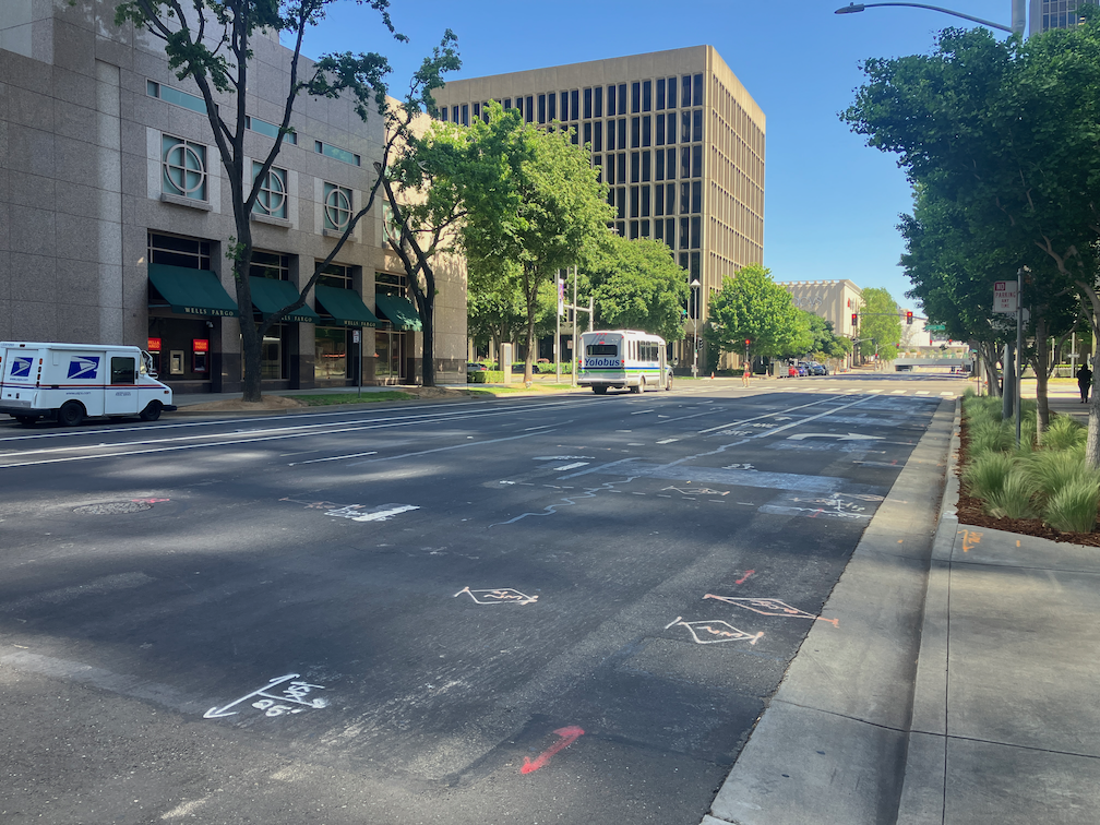
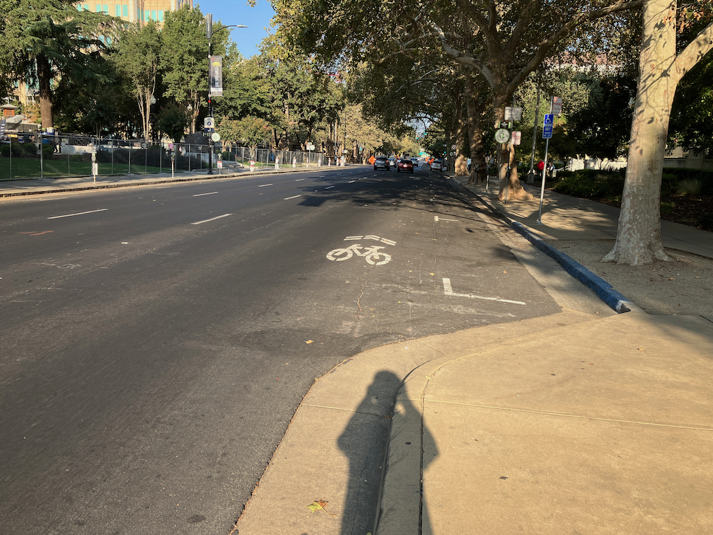
Next sharrows location to address is I Street between 10th Street and 9th Street. The bike lane present to the east disappears in this block, with Cesar Chavez Plaza on the south and Old City Hall on the north, before picking up again west of 9th Street. Not having my tape measure out (and I’d have to measure late night when there is no traffic), it isn’t clear why this one block does not have a bike lane. It may be that the curb extension is too wide, or it may be that the general purpose (car) lanes are not configured correctly. If lanes, then it is an easy problem to fix, just re-stripe the lanes and add a bike lane. If the curb extension, then that would require a bit of infrastructure work. I fully support curb extensions, nearly all intersections should have them, but in some places the city has installed them incorrectly and caused issues for bicycle facilities. This is not, as many places are, a case for removing parking, but for designing the street correctly. Of course ultimately there should be no three-lane one-way traffic sewers in the city, and right of way should be reallocated to a separated (protected) bikeway and wider sidewalks.
I St westbound at 10th St, Sacramento
Caveat: I post about issues in the central city because I live here, and see the problems every time I am out walking or bicycling. However, I strongly believe that the city should be focused on solving issues in lower income, disinvested neighborhoods, of which there are ample throughout the city. The central city has received more than its share of bike facilities.
Note: updated 2020-03-28 to correct lane descriptions and add a photo of the lane shift.
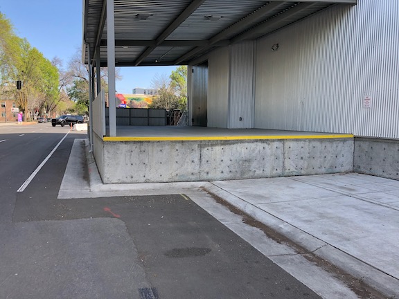
On the south side of I Street, between 15th Street and 16th Street, the city has permanently closed the sidewalk. This was to construct a loading dock for Memorial Auditorium. I had noticed the construction going on there, the first phase of the city’s project for the convention center and community center theater, and just assumed things would be returned to normal when construction was complete. How wrong I was. I was flabbergasted when I saw this. The loading dock sticks quite a ways into what used to be the public right of way, erasing the sidewalk and two parking lanes (the general purpose lanes were shifted to the right). The loading dock is concrete, intended to be there forever. See the photos below.
If the loading area was really than important, and could not be provided anywhere else, the city could have set things up for easy temporary closure of some of the street so as to allow loading when needed. They did not, they made it permanent.
I have walked by here, on the sidewalk, when events were going on at the Memorial Auditorium and there were a lot of walkers using this sidewalk. I imagine for a lot of other uses as well.
Also note that the ‘ bike lane’ stripe does not meet standards for a bike lane because it is immediately adjacent to a hard barrier and fence, so requires shy distance not provided. So that means when there are eventually bike lanes on I Street, this will be a gap, permanently.
What the fuck were you thinking, City of Sacramento?
I Street, south side, east of 15th StreetI Street, south side, east of 15th StreetI Street, south side, west of 16th StreetI Street, south side, west of 16th StreetI Street westbound, lanes shifted right
“bicycles must turn right” sign, I Street between 6th and 5th
I wrote previously about the The I Street Mess. A small change has taken place here, with a new sign that says “Bicycles Must Turn Right” on the bike lane midway between 6th and 5th. Basically, this is a warning to bicyclists who missed the “Thru Bikes Merge Left” sign at the beginning of the block that they are truly screwed. By this point, bicyclist will have a very hard time merging across four lanes of high speed traffic to reach the left side bike lane that takes one to Old Sacramento or 3rd Street. At a minimum, the warnings need to occur earlier, in the block between 7th and 6th. Better yet would be slowing the traffic on I Street so that a bicyclist could actually maneuver through the traffic lanes. Best would be an alternate route for bicyclists who don’t wish to ride vehicularly, that avoids the I Street Mess completely.
I Street entrance to Old Sacramento, from Envision Sacramento
The topic uses the photo at right to illustrate the question. What you can’t see in the photo is that behind the photographer and across 3rd Street (to the left), pedestrian access is on the south side, but to the west, it is on the north side.
Comments include a number about the aesthetics of this entrance to Old Sacramento, including the having a dark freeway under crossing as the main route into the one of the highlights of Sacramento, with poor signing for motor vehicle drivers, bicyclists, and pedestrians. A surprising (to me) number of comments, though, were about the transportation aspects, that it is really not safe for bicyclists or pedestrians to use this entrance, even if they know it is there, and the paucity of other options. I think it is clear that the commenters agreed that the way in which Interstate 5 severed the connections between downtown and Old Sacramento is a major issue.
A gallery of photos shows some of the specific problems at this location.
These photos are of the I Street entrance to Old Sacramento, showing various problems and hazards that exist for pedestrians and bicyclists at this location. The crosswalks here are not really safe. All sorts of signing has been installed to try to make them safe, but that is a poor substitute for correct design. The […]