Re-upping the Elvas Ave and Hornet Tunnel post from earlier this year. It has been reported to me by a number of bicyclists, and I have experienced it myself, that this section of Elvas between the Hornet Tunnel and the signal at 62nd Street has become significantly more hazardous due to the motor vehicle traffic generated by The Line (a collection of various food vendors, opened 2022) and Garden at the Line (an outdoor eating and drinking area adjacent to The Line, opened this December). There is a lot more come and go parking on Elvas, and a lot more motor vehicle traffic in and out of the parking lots. Most bicyclists ride on the sidewalk to avoid the fast-moving traffic, otherwise the crash rate would be higher. The M Street to Elvas Avenue to Hornet Tunnel route is probably the busiest in the city.
In addition to the previous post (reblog below) about the hazards for bicyclists, this area is now hazardous for walkers along and crossing Elvas.
I was there last night for the SABA social gathering, and the place was packed. People were parking along the west side of Elvas as well as on 63rd Avenue and 64th Avenue, and then trying to cross Elvas to Garden at the Line. It was nearly impossible to cross, as there are no marked crosswalks over Elvas at either street, drivers are going fast, and Elvas is not well lit. The speed limit in this section is 40 mph, which almost guarantees that walkers hit by cars will die. Sidewalks on both sides of Elvas are in poor condition, and rolled curbs are common, which are less safe for people walking than vertical curbs. There are no sidewalk buffers. While this section of Elvas is not one of the top 5 or top 10 Vision Zero corridors, it will quickly become so. In the last five years, there have been two injury crashes on this stretch, one bicyclist and one walker, both in the vicinity of Hornet Tunnel.
The city has no plans to improve safety for bicyclists or walkers on this stretch of Elvas.
The section of Elvas Avenue between 62nd Street and Hornet Tunnel which leads to Sac State is very dangerous for bicyclists. Bicyclists have to transition across four lanes of traffic (three travel lanes and a center turn lane), without any protection whatsoever. The pavement quality is low, particularly on the east side where the ‘bike lane’ (not a real bike lane) is. Despite this, it is a high-use bicycle route from Sacramento to Sac State and the American River Parkway trail. M Street, this section of Elvas, and the Hornet Tunnel serve as a bicycle boulevard (though not designated) between the central city, Sac State, and beyond.
Since the day I arrived in Sacramento and rode my bike to work in the eastern suburbs, I have known that this section needs to be fixed. It took me 12 years to get around to writing about it. I hope that it will take the city less to fix it. The solution presented here is not the only solution, so I encourage others to comment, point out flaws, and suggest optimal solutions.
Elvas Avenue is a high-speed, moderately high-volume roadway that acts in many ways as an expressway due primarily to the turns from Elvas Avenue to 65th Street, and from 65th Street to Elvas that encourage high speeds. The roadway is dangerous for motor vehicle drivers and passengers as well as bicyclists. North of 62nd Street, St. Francis High School (about 1100 students) suffers from traffic risk created by Elvas Avenue, so traffic calming to the south will benefit the high school as well as bicyclists. It might be appropriate to extend the separated bikeway north to the signalized crosswalk over Elvas to the school.
I have long been planning to write about the extremely poor bicyclist facilities from M Street to Hornet Tunnel, which is a major access point for Sac State.
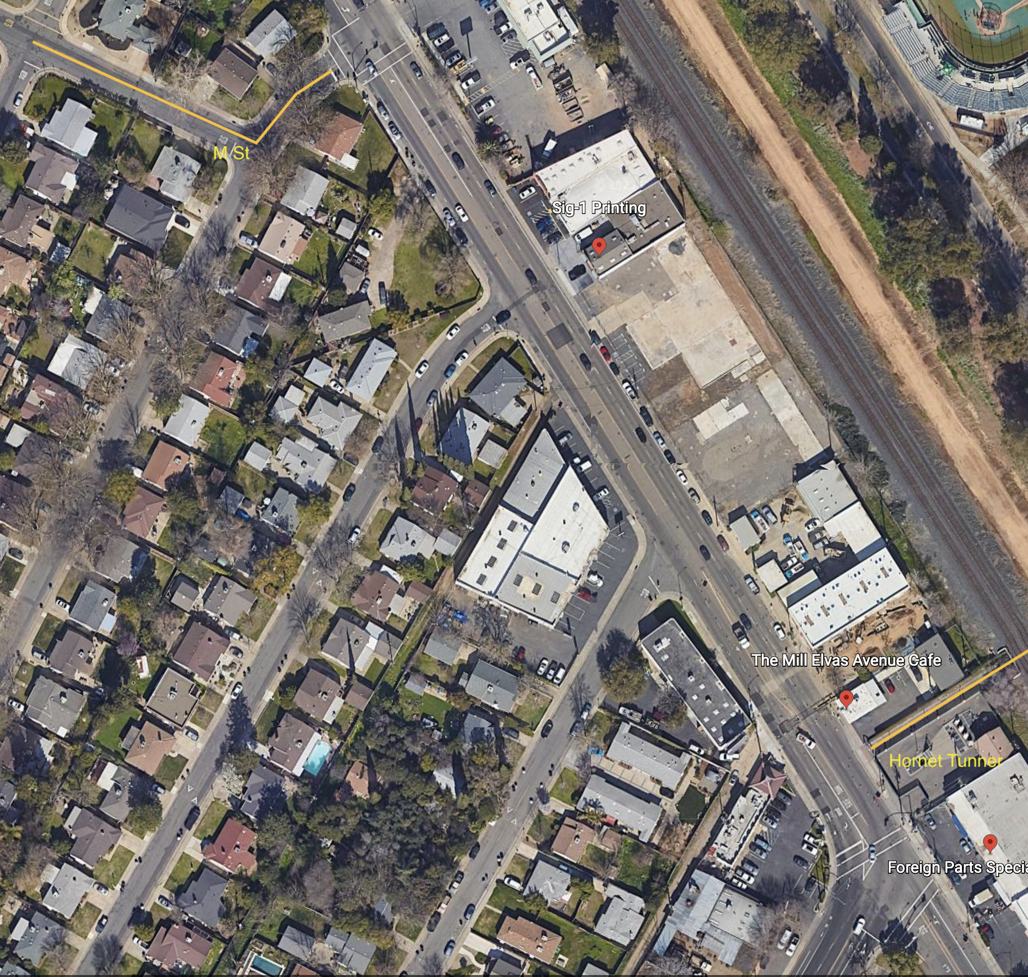
M Street is a major east-west bicycle route, with some but not all of it marked as a bicycle route. If the city used the bicycle boulevard designation, it would be designated a bicycle boulevard. M Street forms an uncontrolled T-intersection with 62nd Street, which leads a short way left to a signalized T-intersection with Elvas Ave.
Hornet Tunnel is a major access point to Sac State campus, probably second only to the Guy West bridge access on the north side.
The map below shows M Street, 62nd Street, Elvas Ave, and Hornet Tunnel, as it exists.
The route from M Street to Hornet Tunnel is heavily used by bicyclists, both students and people passing through to the American River Parkway paths. It would be much more heavily used if it were safe, but it is not.
Eastbound to campus, one must cross over four lanes somewhere between 62nd Street and the median along Elvas Ave, and then ride on the wrong side of the street to reach Hornet Tunnel. Westbound, it is not bad, only having to merge over the northbound lanes to a dedicated left turn lane to 62nd Street. The signal here is surprisingly responsive to bicyclists, so the wait is usually short.
At the 62nd Street & Elvas Ave intersection, Elvas is 62 feet wide, 70 feet with sidewalks. There are shoulder stripes setting off unofficial parking, one southbound lane, one center turn lane, and two northbound lanes. At 64th Ave, Elvas is 68 feet wide, 76 feet with sideewalks. At Hornet Tunnel, Elvas is 63 feet wide, 77 feet with sidewalks, with two northbound lanes and three southbound lanes, two of which are dedicated right turn lanes to 65th Street. Elvas was formerly wider at Hornet Tunnel, but some sidewalk was added there to ease crowding at the tunnel entrance/exit. Given the city-preferred, though unnecessarily wide 11 foot travel lanes, there is room for six lanes of traffic here! That means there is ample room for bicycle facilities. But there are none present.
Some bicyclists take the striped shoulders to be bike lanes, but they are not. The city’s 2018 Bikeway Master Plan shows this section of Elvas between 65th Street and Hornet Tunnel as a Class 2 (on-street) bike lane, but this is false. It is not indicated as such with either pavement markings or signage. Though the shoulder stripe southbound has the dashed marking often used to indicate a bike lane approaching an intersection, this is a fake. It is NOT a bike lane. People park along this stretch, so even if it were a bike lane, it would not be safe nor meet minimal standards for a bike lane.
Solutions
What street redesign and reallocation would make is safer for bicyclists?
First, for northbound bicyclists, there should be a separated bikeway on the right side of the street. Along this section, there are four driveways and a stretch of street-oriented perpendicular parking (where vehicles enter directly into parking spaces from the street). There is a section of 270 feet with no existing buildings. Though there could be parking protected bikeway along here, I don’t think the parking is even needed. Instead, this is probably a good location for a curb separated bikeway, with hard curb to prevent encroachment on bicyclists. The curb would be cut only for driveways which are currently in use. The existing parking along this stretch is used mostly by students to avoid paying on-campus parking fees. All the businesses have onsite parking. The one business that might reasonably need short-term parking on Elvas is The Mill coffee shop. Separated bikeways work best with long stretches without driveways, but one here is workable.
Southbound is more complicated. If there were a bike lane or separated bikeway on the southbound side of Elvas, bicyclists would still need to cross to Hornet Tunnel, at a location where there is currently no way to do so. I see three options:
First, have bicyclists ride south to the existing 65th Street & Elvas Ave intersection, and use the crosswalk on the north side to cross over and then go north to the tunnel. This is very awkward, out of the way, and encourages bicyclists to use a crosswalk, which is not illegal but poor practice.
Second is to create a two-way separated bikeway (often called a cycletrack) on the east side of Elvas, from 62nd Street to the tunnel. A separate bicyclist signal phase would need to be created for northbound bicyclists to cross to 62nd Street, and southbound bicyclists to cross to the east side of Elvas Ave. An advantage to this solution is that parking on the west side of Elvas does not need to be changed, though it can be reasonably argued that there should be at least a regular bike lane here for bicyclists who are not going to the tunnel, but continuing south on Elvas or south on 65th Street.
Third, have bicyclists continue southbound on Elvas, but create a clear zone for crossing to the tunnel by signalization. Northbound motor vehicles would be held by the existing signal at the intersection of 65th Street and Elvas Ave, while southbound motor vehicles would be held at a stop line just north of the tunnel by new signal heads. Bicyclists would cross to the tunnel during the red phase. There would need to be queuing area for southbound bicyclists, since they would exceed the stacking capacity of the bike lane during busy times. This option probably slows motor vehicle throughput more than the other options.
No matter which solution, the sidewalks along Elvas Ave should be repaired and widened, and street trees should be planted. And of course the street needs to be repaved.
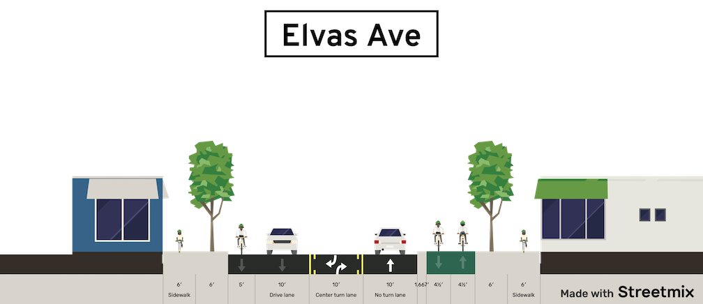
Below is a Streetsmix diagram showing one possible configuration (looking north) with a two-way separated bikeway (cycletrack) on the east side, along with wider sidewalks and trees in a planing strip, and a southbound regular bike lane. And yes, all this fits in the existing over-wide Elvas Ave right-of-way!